
P-34668 This narrow angled image of Neptune's Triton, part of a sequence recieved from Voyager 2 shows a large flooded basin about 200 km. or 120 miles wide and 400 km. or 240 miles long. It appears to have been formed chiefly by two large,…

This photomosaic of Triton, assembled from 14 individual frames, shows the great variety of its surface features. At the bottom of the image are remnants of the south polar cap, containing 'dark' streaks generally aligned towards the nort…
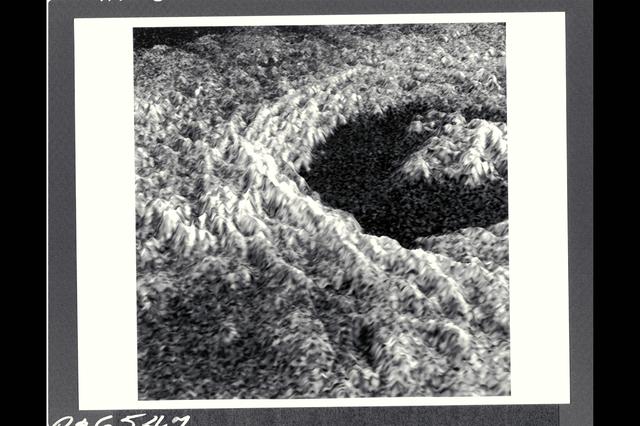
This three-dimensional representation of brightness variations in a Magellan radar image of Golubkina crater enhances the structural features of the crater. Golubkina is 34 kimometers (20.4 mi.) in diameter, and is located at about 60.5 de…

The northern hemisphere is displayed in this global view of the surface of Venus. The north pole is at the center of the image; with 0 degrees, 90 degrees , 180 degrees, 270 degrees east longitudes at 6, 3, 12 and 9 0'clock positions, repe…

August 17 to 19, 1989 Range : 11.5 million km (7.1 million mi.) to 7.9 million km (4.9 million mi.) Four black and white images of Neptune's largest satellite, Triton, show it's rotation between the first (upper left) image and the last (l…

P-34679 Range : 2 million km. ( 1.2 million miles ) In this Voyager 2, wide-angle image, the two main rings of Neptune can be clearly seen. In the lower part of the frame, the originally-announced ring arc, consisting of three distinct fea…

Range : 3.2 million km This image returned by Voyager 2 shows one of the long dark clouds observed in the North Equatorial Belt of Jupiter. A high, white cloud is seen moving over the darker cloud, providing an indication of the structure…

Range : 350,000 miles This image of the western hemisphere of the Moon was taken through a green filter by Galileo at 9:35 am PST. In the center is the Orientale Basin, 600 miles in diameter, formed about 3.8 billion years ago by the impa…

Range : 5 million km. ( 3 million miles ) This photograph, shot from Voyager I, shows Jupiter's Great Red Spot, turbulent regions immediattely to the west, and, middle right, one of the several white ovals seen on Jupiter from Earth. Thi…

Range : 280,000 km. ( 170,000 miles ) P-34726 BW Two 10 minute exposures of Neptune's rings clearly show the two main rings , as well as the inner faint ring and the faint band that extends planetward from roughly halfway between the two b…

This color reconstruction of part of the northern hemisphere of Ganymede was made from pictures taken at a range of 313,000 km (194,000 mi.). The scene is approx. 1,300 km (806 mi.) across. It shows part of dark, densely cratered block wh…

Range : 4 million km (2.5 million miles) Already-intriquing patterns of unknown origin appear on the surgace of Neptune's largest satellite, Trition, in this image from Voyager 2. Voyager images show that Trition's diameter is about 2,720…

Range : 1.2 million kilometers (750,000 miles) This picture of Io is one of the last sequence of 'volcano watch' pictures planned as a time lapse study of the nearest of Jupiter's Galilean satellites. The sunlit crescent of Io is seen at…

Range : 220,000 mi. (left)/350,000 mi. (right) These pictures of the Moon were taken by the Galileo spacecraft. Image on the right shows the dark Oceanus Procellarum in the upper center, with Mare Imbrium above it and the smaller circular…

Range : 40,000 km (24,8000 mi.) This picture of Triton is a mosaic of the highest resolution images taken by Voyager 2. The mosaic is superimposed on the lower-resolution mapping images taken about 2 hours earlier in order to fill in gaps…

This portion of a Magellan radar image strip shows a small region on Venus 20 km (12.4 mi.) wide and 75 km (50 mi.) long on the east flank of a major volcanic upland called Beta Regio. The image is centerd at 23 degrees north latitude and…

P-34705 This false-color photograph of Neptune was made from Voyager 2 images taken through three filters: blue, green, and a filter that passes light at a wavelength that is absorbed by methane gas. Thus, regions that appear white or brigh…

P-21738 BW Raange: 4.76 million kilometers (2.9 million miles) This Voyager 2 picture of Io was taken in ultraviolet light and shows one of the volcanic eruption plumes first photographed by Voyager 1. (the bright spot on the right limb) Th…

Range : 7 million kilometers (4.3 million miles) Io is Jupiter's innermost of the four Galilean satellites. Photo taken at 2:00 AM through an ultraviolet filter. The photo's background is part of Jupiter's disk. North is at the top and th…

Range : 1 illion km. ( 600,000 mi. ) Resolution : 140 km. ( 90 mi. ) P-29539C This Voyager 2 image of Uranus was captured as the spacecraft was leaving Uranus behind on its cruise to Neptune. The image is a color composite of three photog…
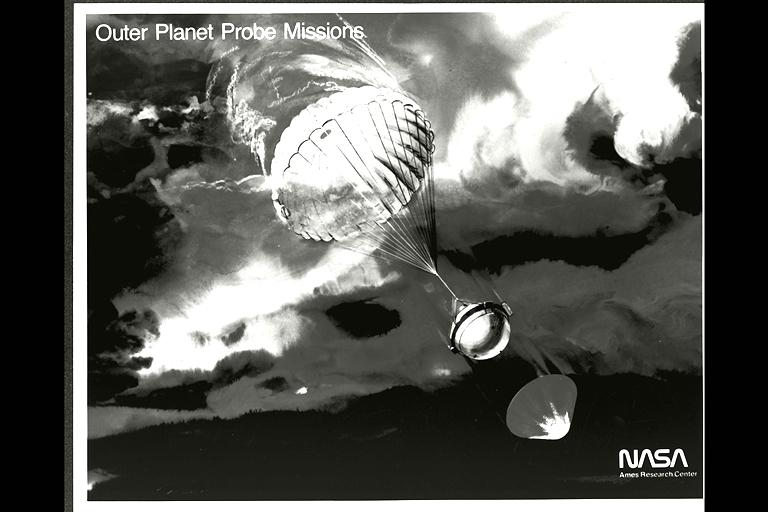
(P-19180) Galileo Probe descending into Jupiters atmosphere (artwork)

P-34764 Voyager 2 obtained this high resolution color image of Neptune's large satellite Triton during its close flyby. Approximately a dozen individual images were combined to produce this comprehensive view of the Neptune-facing hemisph…

P-21745 BW Range: 1.1 million miles (675,000 miles) This image of Callisto taken by Voyager 2 was enhanced to reveal detail in the scene. Voyager 1's high resolution coverage was of the hemisphere just over the right-hand (eastern) horizon…

Range : 900,000 miles A brilliant halo around Jupiter, the thin ring of particles discovered by Voyager 1 four months ago, is seen here unusually bright due to forward scattering of the particles within it. Similiarly, the planet is outli…

Range : 660,000 km. ( 412,000 miles ) P-34711 This Voyager 2 wide angle photograph shows the shadow of Neptune on the rings. Because Neptune's shadow casts a curved profile on the rings which does not quite reach out to the outermost ring…

P-21746 BW Range: 390,000 kilometers (245,000 miles) This photomosaic of Callisto is composed of nine frames. The impact crater distribution is very uniform across the disk. Notable are the very bright rayed craters that probably are very y…

Range : 6.1 million km ( 3.8 million miles) This image of clouds in Neptune's atmosphere is the first that tests the accuracy of the weather forecast that was made eight days earlier to select targets for the Voyager narrow-angle camer. T…

P-21735 BW This Jupiter image taken by Voyager 2 shows an area from 10° N. Lat. to 34° S. Lat. in a region west of the Great Red Spot. At the top of the picture, equatorial plumes are seen. These features move along the edge of the equato…

Range : 12 million km. ( 7.56 million miles) P-23057C & BW This Voyager 1 photograph of Titan, the largest of Saturn's 14 known satellites, shows little more than the upper layers of clouds covering the moon. The orange colored haze, is be…

P-29509 C Range: 500,000 kilometers (300,000 miles) This high-resolution color composite of Titania was made as Voyager 2 neared its closest approach to Uranus. Voyager's narrow-angle camera acquired this image through the violet and clear…

P-34718 Range: 210,000 kilometers (128,000 miles) This natural color image of the limb of Triton shows the largest surface features at about 3 miles across. The picture is a composite of images taken through the violet, green and clear filt…

Range : 3.4 million km This pair of images shows two of the long-lived white oval clouds which have resided in the Jovian southern hemisphere for nearly 40 years. The upper picture shows the cloud that is at a longitude west of the Great…

Range : 1.4 to 2 million miles These are enhanced versions of four views of Venus taken by Galileo's Solid State Imaging System. The pictures in the top row were taken about 4 and 5 days after closest approach, and those in the bottom row…

Resolution : 2 km. ( 1.2 miles ) P-24069C In this computer generated photograph, created from a cross section of Saturn's rings by Voyager 2 photopolarimeter's star occulation, the Encke Division in the outer A-ring. Clearly shown is the c…

P-34615 These three color images of Triton were taken at three different orbital longitudes to show different faces of the neptune moon. the overall pinkish cast of the images may be due to the presence of reddish material on Triton produc…

Range : 1.7 million miles This colorized picture of Venus was taken about 6 days after Galileo's closest approach to the planet. It has been colorized to a bluish hue to emphasize subtle contrasts in the cloud markings and to indicate tha…

P-34698 These Voyager 2 images of satellite 1989N2 at a resolution of 4.2 kilometers (2.6 miles) per pixel reveals it to be an irregularly shaped, dark object. The satellite appears to have several craters 30 to 50 kilometers (18.5 to 31 mi…

210' Dish Antenna at Goldstone Ca - used in tracking Pioneer spacecraft

Range : 35,000 miles plus. This color image of the Simpson Desert in Australia was obtained by the Galileo spacecraft at aboaut 2:30 pm PST. The color composite was made from images taken through the red, green and violet filters. The ar…

This color picture of the limb of the Earth, looking north past Antarctica, is a mosaic of 11 images taken during a ten-minute period near 5:45 p.m. PST Dec. 8, 1990, by Galileo's imaging system. Red, green and violet filters were used. T…

P-29522BW Range: 369,000 kilometers (229,000 miles) This is the highest-resolution picture of Titania returned by Voyager 2. The picture is a composite of two images taken through the clear-filter of Voyager's narrow-angle camera. The resol…

Range : 4 billion miles from Earth, at 32 degrees to the ecliptic. P-36057C This color image of the Sun, Earth, and Venus is one of the first, and maybe, only images that show are solar system from such a vantage point. The image is a port…

Range : 2.3 million km. ( 1.4 million miles ) P-24067C This Voyager 2 photograph of Titan, a satellite of Saturn, shows some detail in the cloud systems. The southern hemisphere appears lighter in contrast, a well defined band is seen nea…

P-21756 BW only Range: 120,000 km (right) 169,000 km (left) Right: In the foreground of this picture taken by Voyager 2, the part of the surface of Ganymede shown is the typical grooved terrain as seen by Voyager 1. It consists of mutually…

Deep Space Antenna 210' at Goldstone, CA (JPL ref: P-116594AC)

Range : top- 86,000 miles bottom- 192,000 mi. These two close-ups of Ganymede, the largest of Jupiter's 13 moons, show different views of the largest block of dark, heavily cratered terrain. The bottom image shows objects 3 or 4 miles ac…

JUPITER'S FAINT RING SYSTEM IS SHOWN HERE AS TWO ORANGE LINES PROTRUDE FROM THE LEFT TOWARD JUPITER'S LIMB. THIS COLORFUL COMPOSITE WAS TAKEN IN JUPITER'S SHADOW THROUGH ORANGE AND VIOLET FILTERS. THE COLORFUL IMAGES OF JUPITER'S LIMB ARE…

P-29513 BW Range: 31,000 kilometers (19,000 miles) This Voyager 2 image of Miranda was taken shortly before the spacecraft's closet approach to the Uranian moon.The high resolution of 600 meters (2,000 feet) reveals a bewildering variety of…