Glenn Research Center Hangar at Sunrise
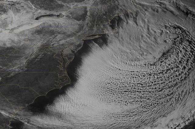
The monster winter storm that brought icing to the U.S. southeast moved northward along the Eastern Seaboard and brought snow, sleet and rain from the Mid-Atlantic to New England on February 13. A new image from NOAA's GOES satellite showed…
Satellite Views Powerful Winter Storm Battering Mid-Atlantic and New England
NASA-NOAA's Suomi NPP satellite passed over the large low pressure area on January 22 at 1855 UTC (1:55 p.m. EST) that stretched from New England south to Florida. Credit: Credits: NASA/NOAA/Goddard Rapid Response Team  Credit: NASA/Goddard…
Winter storm over the eastern United States
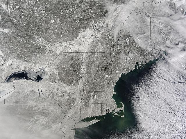
NASA image acquired January 24, 2011  What do you get when you mix below-freezing air temperatures, frigid northwest winds from Canada, and ocean temperatures hovering around 39 to 40 degrees Fahrenheit (4 to 5 degrees Celsius)? Paved highw…
Winter Cloud Streets, North Atlantic
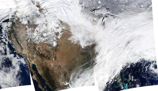
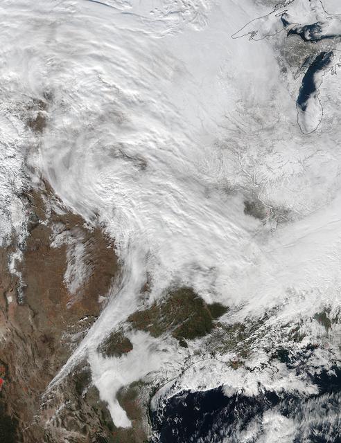
On January 2, 2014, NASA’s Aqua satellite passed over the United States mutiple times showing winter weather, allowing the Moderate Resolution Imaging Spectroradiometer (MODIS) on board to capture this true-color image of a massive winter s…
USA Composite Reveals Massive Winter Storm - January 02, 2014
On March 3, a major winter storm brought snow to the mid-Atlantic, freezing rain to the Carolinas and rain and some freezing rain to the Gulf Coast states. NOAA's GOES-East satellite captured an image of the clouds associated with the winte…
Satellite Sees Winter Storm March Over Mid-Atlantic
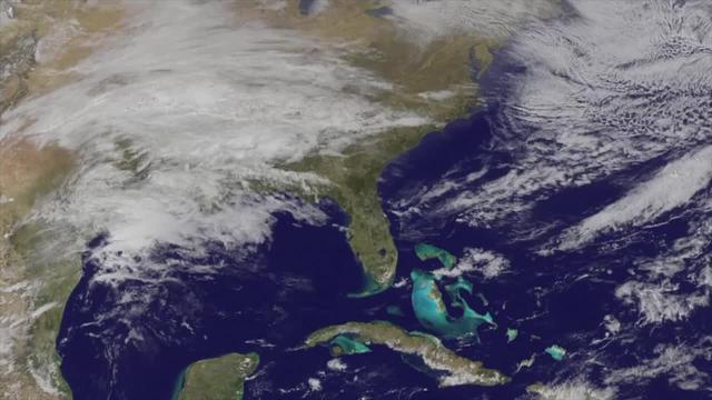
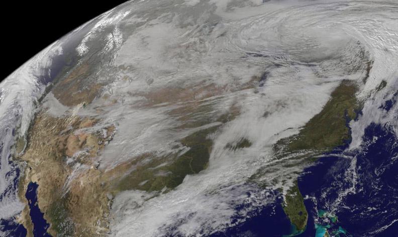
 NASA satellite imagery captured the size of the massive winter storm that continued to pummel the U.S. East Coast early on January 23, 2016.  This visible image of the major winter storm was taken from NOAA's GOES-East satellite on Saturda…
NASA Sees Winter Storm Slamming Eastern United States
NASA and NOAA satellites are providing various views of the major winter storm marching toward the U.S. East coast on March 13. The storm is forecast to merge with another system and is expected to bring large snowfall totals from the Mid-A…
Satellites see major winter storm marching toward the U.S. East Coast
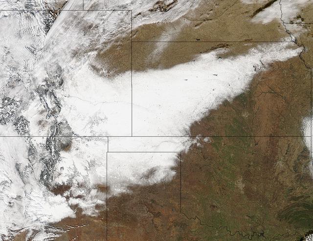
Winter arrived officially on Dec. 22 at 12:35 a.m. EST, but the U.S. Plains states received an early and cool welcome on Dec. 19 from heavy snowfall that was seen by a NASA satellite.   NASA's Aqua satellite passed overhead on Dec. 21 at 20…
First Day of Winter Obvious on NASA Satellite Image of the U.S. Plains States
NASA's first ever historic P-3B landing in McMurdo Station, Antarctica on the sea ice runway, which occurred on Nov. 16, 2013. It took the craft 5 days to reach Antarctica from the NASA Wallops Flight Facility in Wallops Island, Virginia. Y…
Historic First Landing of NASA's P-3B in Antarctica
New Horizons principal investigator Alan Stern of the Southwest Research Institute (SwRI), Boulder, CO and New Horizons project manager Helene Winters of the Johns Hopkins University Applied Physics Laboratory discuss the various teams have…
New Horizons Ultima Thule Flyby
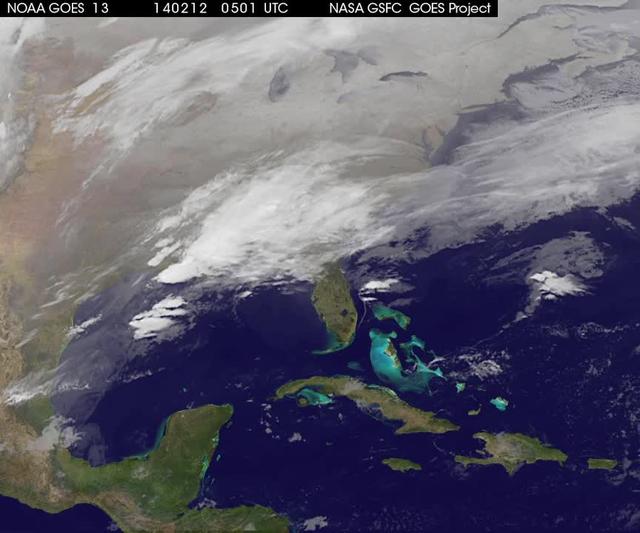
<b>View a video of the storm here: <a href="http://bit.ly/1m9aJFY" rel="nofollow">bit.ly/1m9aJFY</a></b>  This visible image of the winter storm over the U.S. south and East Coast was taken by NOAA's GOES-13 satellite on Feb. 12 at 1855 UTC…
Satellite Video Shows Movement of Major U.S. Winter Storm
NASA's P-3B airborne laboratory on the ramp at Thule Air Base in Greenland early on the morning of Mar. 21, 2013.   Credit: NASA/Goddard/Christy Hansen  NASA's Operation IceBridge is an airborne science mission to study Earth's polar ice. F…
NASA's P-3 at Sunrise
<b>View detail image here: <a href="http://bit.ly/1bvJlaN" rel="nofollow">bit.ly/1bvJlaN</a></b>  Arctic air has surged into the U.S. pushing into the Southeastern states and dropping high temperatures there into the 20s with colder wind ch…
Satellite Shows an "Arctic Blanket" Over the U.S.
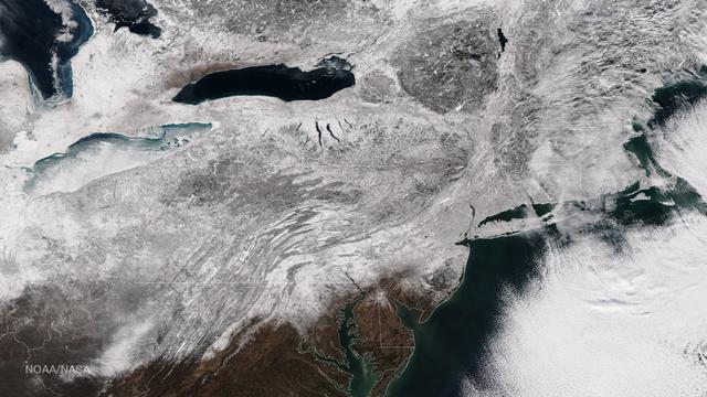
NOAA's GOES-East satellite provided a look at the frigid eastern two-thirds of the U.S. on Jan. 7, 2015, that shows a blanket of northern snow, lake-effect snow from the Great Lakes and clouds behind the Arctic cold front.   A visible pictu…
Satellite Picture Shows the Snow-covered U.S. Deep Freeze
NASA Shuttle Weather Officer Kathy Winters participates in the space shuttle Discovery launch status briefing on Friday, Oct. 29, 2010 at the NASA Kennedy Space Center in Cape Canaveral, Fla.  Discovery and it's STS-133 mission crew of six…
STS-133 Briefing
Glenn Research Center Hangar at Sunrise
The monster winter storm that brought icing to the U.S. southeast moved northward along the Eastern Seaboard and brought snow, sleet and rain from the Mid-Atlantic to New England on February 13. A new image from NOAA's GOES satellite showed…
Satellite Views Powerful Winter Storm Battering Mid-Atlantic and New England
A large winter system is moving across the United States and is combining with cold air moving down from Canada, bringing snow to some areas. Major travel impacts are expected along the main highways throughout the eastern U.S. This true co…
Winter Weather Will Make a Wet Thanksgiving
The sea ice cap of the Arctic appeared to reach its annual maximum winter extent on February 25, according to data from the NASA-supported National Snow and Ice Data Center (NSIDC) at the University of Colorado, Boulder. At 5.61 million squ…
Arctic Sea Ice Sets New Record Winter Low
NASA image acquired February 24, 2012  By late February, 2012, the great European cold wave had begun to loosen its frigid grip, but significant snow still remained in the region. The Moderate Resolution Imaging Spectroradiometer (MODIS) ab…
Snow in Italy
Clouds associated with the major winter storm that is bringing wintry precipitation and chilly temperatures to the U.S. south is the focus in an image from NOAA's GOES-East satellite today, February 12 at 1310 UTC/ 8:10 EST.  Rain, freezing…
Satellite Shows Major Winter Storm Hitting the U.S. South
Yet another potent winter storm battered the northeastern United States on February 14-15, 2015. The nor'easter brought 12 to 20 inches (30 to 50 centimeters) of snow across much of eastern New England, along with tropical storm force winds…
Another Blizzard Piles Up the Snow in New England
As the storm moves offshore and the skies clear over the Northeast United States, the extent of snowfall from the blizzard is shown in this image from the Suomi NPP satellite imagery, taken on January 28, 2015 at 1:50 EST. Portions of Suffo…
Blizzard Blankets the Northeast With Snow
This satellite imagery from Jan. 21 at 10:00 a.m. EST shows the large winter storm over near the Gulf coast and another storm approaching the Pacific coast.  Credits: NASA/NOAA GOES Project  <b><a href="http://www.nasa.gov/audience/formedia…
NASA Sees Major Winter Storm Headed for Eastern U.S.
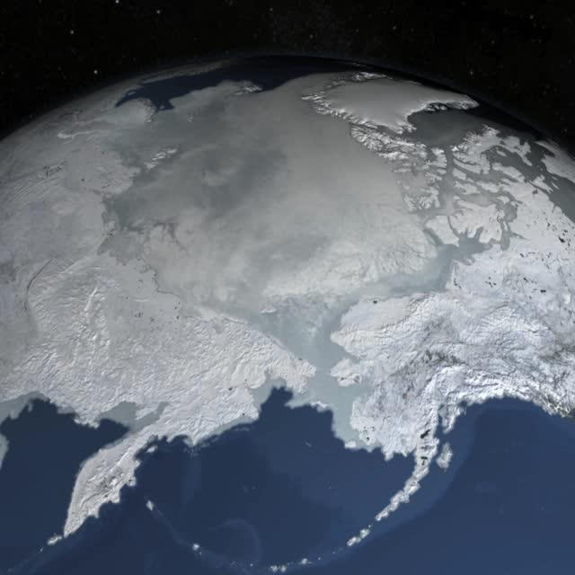
On February 4, 2014 the Moderate Resolution Imaging Spectroradiometer (MODIS) flying aboard NASA’s Aqua satellite captured a true-color image of sea ice off of western Alaska.  In this true-color image, the snow and ice covered land appears…
Sea ice off western Alaska
New Horizons project manager Helene Winters of the Johns Hopkins University Applied Physics Laboratory speaks at a press conference prior to the flyby of Ultima Thule by the New Horizons spacecraft, Monday, Dec. 31, 2018 at Johns Hopkins Un…
New Horizons Ultima Thule Flyby
New Horizons project manager Helene Winters of the Johns Hopkins University Applied Physics Laboratory speaks during a press conference prior to the flyby of Ultima Thule by the New Horizons spacecraft, Monday, Dec. 31, 2018 at Johns Hopkin…
New Horizons Ultima Thule Flyby
Another large snowstorm affecting New England was dropping more snow on the region and breaking records on February 9, as NOAA's GOES-East satellite captured an image of the clouds associated with the storm system.  On Feb. 9, NOAA's Nation…
Satellite Eyes New England Winter Storm Breaking Records
As icy cold Canadian air settled over the eastern two-thirds of the U.S. bringing snow and bitter cold, NOAA's GOES-East satellite captured this infrared view of what looks like a frozen blanket over the region.  NOAA's GOES-East satellite…
Satellite View of the U.S. Wrapped in a Frozen Blanket
The strong coastal storm currently off the coast of New England will continue to bring strong winds and heavy snow to coastal portions of the Northeast on Wednesday. The storm will move into the Canadian Maritimes by Thursday.   This image…
Spring Storm Hits New England
A winter storm that moved through the Mid-Atlantic on Feb. 16 and 17, 2015 extended the northeastern U.S. snowcover farther south. Until this storm hit, southern New Jersey and southeastern Pennsylvania appeared snow-free on satellite image…
NASA Sees Winter's Northeastern U.S. Snowcover Extend Farther South
This image shows the strom system on Dec. 10, 2013 at 1445 UTC.  According to the National Weather Service snow is falling from Tennessee Valley into the Mid-Atlantic and New England Tuesday . The fast moving system is creating swath of 2 t…
winter storm hits mid-Atlantic region
On Nov. 12, NOAA's GOES satellite showed the storm system that brought wintry weather entire U.S. centered near Ontario, Canada. Snow is visible in the U.S. and Canadian Rockies.  Read more: <a href="http://www.nasa.gov/content/goddard/new-…
Satellite Shows U.S. Pre-Winter Wintry Outbreak
This full disc image of earth  shows the strom system   on Dec. 10, 2013 at 1445 UTC.  According to the National Weather Service snow is falling from Tennessee Valley into the Mid-Atlantic and New England Tuesday . The fast moving system is…
Winter storm Hits Mid-Atlantic Region
In February 2015, New England was not alone in dealing with the wrath of Old Man Winter. Thick snow blanketed mountain ranges in southwestern Europe after a winter storm pushed through the region in early February. The Moderate Resolution I…
Snow in southwestern Europe
Iceland, dressed in winter white, peaked through a hole in a complex system of clouds in late February, 2015. The Moderate Resolution Imaging Spectroradiometer (MODIS) aboard NASA’s Terra satellite captured this true-color image on February…
Iceland
Image acquired December 22, 2011  NOAA's GOES-13 satellite captured this image of Earth on the first day of  the winter solstice, December 22, 2011 at 11:45 UTC. The GOES-13 cloud images are overlaid on a true-color NASA/MODIS map by the NA…
Winter Solstice Arrives in Northern Hemisphere
Though North America is a full month into astronomical spring, the Great Lakes have been slow to give up on winter. As of April 22, 2014, the Great Lakes were 33.9 percent ice covered. The lake they call Superior dominated the pack. In the…
Persistent Ice on Lake Superior
A new NASA video of NOAA's GOES satellite imagery shows three days of movement of the massive winter storm that stretches from the southern U.S. to the northeast.  Visible and infrared imagery from NOAA's GOES-East or GOES-13 satellite from…
Satellite Video Shows Movement of Major U.S. Winter Storm
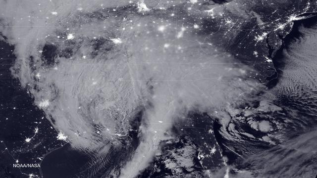
NASA and NOAA satellites are tracking the large winter storm that is expected to bring heavy snowfall to the U.S. mid-Atlantic region on Jan. 22 and 23. NASA-NOAA's Suomi NPP satellite snapped this image of the approaching blizzard around 2…
Blizzard Bears Down on U.S. East Coast
On Jan. 20 at 2:30 p.m. EST the VIIRS instrument aboard NASA-NOAA's Suomi NPP captured this image of the winter storm moving through the central U.S.  Credits: NASA Goddard Rapid Response  The low pressure area from the Eastern Pacific Ocea…
NASA Sees Major Winter Storm Headed for Eastern U.S.
Arctic air has surged into the U.S. pushing into the Southeastern states and dropping high temperatures there into the 20s with colder wind chills.   This NOAA GOES-East satellite image was captured at 1445 UTC/9:45 a.m. EST on January 28,…
Satellite Shows an "Arctic Blanket" Over the U.S. [detail]
New Horizons project manager Helene Winters of the Johns Hopkins University Applied Physics Laboratory speaks during an overview of the New Horizons Mission, Monday, Dec. 31, 2018 at Johns Hopkins University Applied Physics Laboratory (APL)…
New Horizons Ultima Thule Flyby
A major winter storm is poised to wallop the Mid-Atlantic and bring large amounts of snow to cities including Baltimore, Md., Washington, D.C. area on March 2 and 3, according to NOAA's National Weather Service. NOAA's GOES-East satellite c…
Satellite Sees Major Winter Storm Ready to Wallop Mid-Atlantic
iss074e0300243 (Feb. 2, 2026) --- The wintry landscape of the southern New England region of the United States is seen from the International Space Station as it orbited 262 miles above North America. Temperatures in Boston, Massachusetts,…
The wintry landscape of the southern New England region of the United States
New Horizons project manager Helene Winters of the Johns Hopkins University Applied Physics Laboratory speaks at a press conference prior to the flyby of Ultima Thule by the New Horizons spacecraft, Monday, Dec. 31, 2018 at Johns Hopkins Un…
New Horizons Ultima Thule Flyby
This image from NOAA's GOES satellite shows the swaths of snow across the Midwest after the weekend storms (December 7 and 8) there. This visible image was captured at 1745 UTC/12:45 p.m. EST on December 10, 2013.  The riverine topography i…
Satellite View of Midwestern Snows