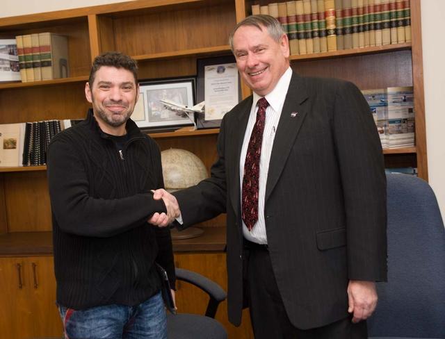
Silicon Valley technology Festival Paco Rafageles, left and Dr Pete Worden, Director Ames Research Center, right sign documents.
ARC-2011-ACD11-0214-007
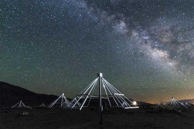
A nighttime shot shows some of the antennas of the Owens Valley Long Wavelength Array in California, with the center of our galaxy in the background.  A video can be seen at https://www.youtube.com/watch?v=vXvHqyOaJrU&feature=youtu.be.   ht…
Scanning the Radio Sky
NASA’s Aqua satellite captured a large area of smoke from the Long Valley Wildfire that was affecting Yosemite National Park.    This natural-color satellite image was collected by the Moderate Resolution Imaging Spectroradiometer instrumen…
NASA Sees Smoke from California’s Long Valley Wildfire
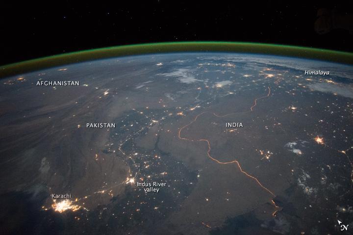
An astronaut aboard the International Space Station took this nighttime panorama while looking north across Pakistan’s Indus River valley. The port city of Karachi is the bright cluster of lights facing the Arabian Sea, which appears comple…
India-Pakistan Border at Night
STS059-225-072 (9-20 April 1994) --- Orient with the tuning fork away from the viewer (sunglint is always south of the spacecraft at this latitude).  Then the South Fork (left) and North Fork (right) of the Shenandoah meet in the foreground…
Earth observations taken during the STS-59 mission
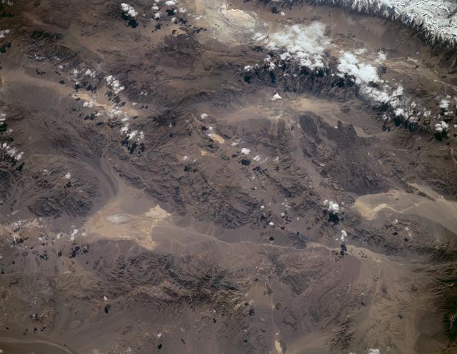
STS059-L09-162 (9-20 April 1994) --- Orient with the snow-covered mountains (Sierra Nevada of California) in the upper right corner.  Then Owens Valley runs along the top of the photograph to Owens Lake playa at top center.  The upper end o…
Sierra Nevada, California as seen from STS-59
Students from Eagle Robotics, Team 399, supported by volunteers from NASA’s Armstrong Flight Research Center in Edwards, California, adjust their robot during the 2025 Aerospace Valley FIRST Robotics Competition in Lancaster, California, on…
NASA Supports Next Generation of Innovators at Robotics Competition
Robotics teams gather on the main floor of the 2025 Aerospace Valley FIRST Robotics Competition at Eastside High School in Lancaster, California, adjusting and testing the functions of their robots, on April 3, 2025
NASA Supports Next Generation of Innovators at Robotics Competition
This view of southern California as seen from the Apollo 7 spacecraft during its 18th revolution of the earth. Photographed from an altitude of 124 nautical miles. The coast of California can be seen from Point Mugu southward to Oceanside.…
Southern California as seen from the Apollo 7 spacecraft
S66-63477 (13 Nov. 1966) --- United Arab Republic (Egypt), the Nile Valley from Luxor to Cairo, El Payium, Gulf of Suez, Sinai as seen from Gemini-12 spacecraft on its 25th revolution of Earth.  Photo credit: NASA
Egypt, Nile Valley, Gulf of Suez, Sinai as seen from Gemini 12 spacecraft
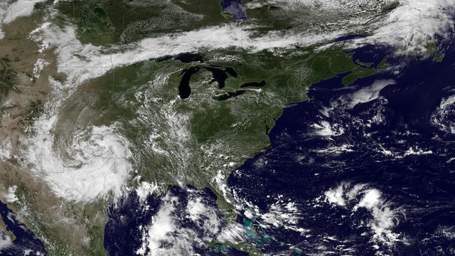
A very anomalous weather pattern is in place over the U.S. for mid-July. Trapped between an upper level ridge centered over the Ohio Valley and the closed upper level low over the Texas/Oklahoma border, atypical hot, muggy air is stifling a…
Heat Wave Building Into the Ohio Valley and Eastern United States
SL3-33-156 (July-September 1973) --- A near vertical view of the Florence, Italy area as photographed from Earth orbit by one of the Itek-furnished S190-A Multispectral Photographic Facility Experiment aboard the Skylab space station. The v…
View of Florence, Italy area from Skylab
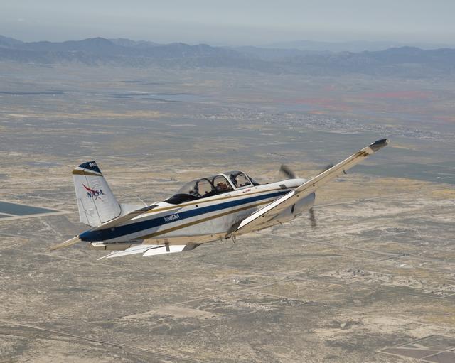
NASA’s T-34 aircraft flown from the agency’s Armstrong Flight Research Center aims the plane toward Southern California’s Antelope Valley Poppy Reserve flying over yellow wildflowers. The aircraft was flown from the agency’s Armstro…
NASA Aircraft flies over yellow wildflowers abundant due to rainy winter season. The T-34 aircraft was flown from the agency's Armstrong Flight Research Center.
NASA's T-34 aircraft flown from the agency's Armstrong Flight Research Center aims the plane toward Southern California's Antelope Valley Poppy Reserve. The aircraft was flown from the agency's Armstrong Flight Research Center.
NASA Aircraft heads to Southern California's Poppy Reserve in the foreground. Rainy Season made the Antelope Valley colorful with poppies and wildflowers.
NASA Systems Engineer Daniel Eng serves his second year as a judge for the Aerospace Valley Robotics Competition at the Palmdale Aerospace Academy in Palmdale, California, in 2019.
NASA Systems Engineer Daniel Eng Judges Robotics Competition
View from a NASA aircraft, TG-14, over the Superbloom of wildflowers and poppies from the Antelope Valley in Southern California. The Poppy Reserve is in the foreground and solar panels are in the background.
Rainy Winter Season Brings Abundance of Wildflowers and Poppies in Southern California’s Antelope Valley showing Poppy Reserve and solar panels are in the background.
This frame from a movie from the Samford Valley Observatory in Brisbane, Australia, shows the progress of asteroid 2012 DA14 across the night sky as it nears its closest approach. It was taken at 12:59 UTC on Feb. 15 7:59 a.m. EST, or 4:59…
Approach of Asteroid 2012 DA14 from Samford Valley Observatory
This rendering was created by research drones flying over Mars Hill, a region of Death Valley National Park that has been used by NASA’s Mars researchers since the 1970s, when the agency was preparing to land the twin Viking spacecraft. The…
Rendering of Mars Hill in Death Valley National Park
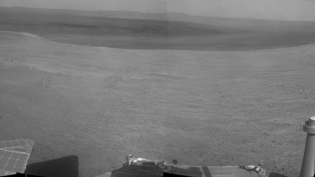
"Perseverance Valley" lies just on the other side of the dip in the crater rim visible in the left half of this 360-degree panorama from the Navigation Camera (Navcam) on NASA's Mars Exploration Rover Opportunity.  As the rover arrived at t…
Crater Rim and Plain at Head of 'Perseverance Valley,' Mars
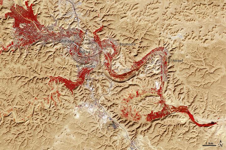
NASA image acquired Feb. 9, 2011  Less than 5 percent of Algeria’s land surface is suitable for growing crops, and most precipitation falls on the Atlas Mountains along the coast. Inland, dust-laden winds blow over rocky plains and sand sea…
M’zab Valley, Algeria
An astronaut aboard the International Space Station took this nighttime panorama while looking north across Pakistan’s Indus River valley. The port city of Karachi is the bright cluster of lights facing the Arabian Sea, which appears comple…
India-Pakistan Border at Night
STS058-91-074 (18 Oct-1 Nov 1993) --- The largest cityscape in the view is Nashville (top left), part of which is obscured under a band of clouds (the Cumberland River, on which Nashville lies, can not be seen under the cloud band).  Close…
Nashville Basin, Tennessee as seen from STS-58
A group of attendees to the 2025 Aerospace Valley FIRST Robotics Competition gather outside Eastside High School’s gymnasium in Lancaster, California, to watch an F/A-18 from NASA’s Armstrong Flight Research Center, in Edwards, California,…
NASA Supports Next Generation of Innovators at Robotics Competition
Jose Vasquez, engineering technician at NASA’s Armstrong Flight Research Center at Edwards, California, machines parts for a robot inside NASA’s mobile machine shop at the 2025 Aerospace Valley FIRST Robotics Competition in Lancaster, Calif…
NASA Supports Next Generation of Innovators at Robotics Competition
STS058-89-013 (18 Oct-1 Nov 1993) --- An oblique westward view, across the wheat fields and cattle pastures, of eastern Colorado to the Front Range of the Rocky Mountains.  Denver is bisected at the center of the right edge of the frame.  P…
Colorado as seen from STS-58
STS058-101-014 (18 Oct-1 Nov 1993) --- The best, most-nearly cloud-free, shuttle view yet of Mount Everest, the highest mountain in the world at 29,028 feet. The peak, on the border between Nepal and China, is almost exactly in the center o…

Mount Everest as seen from STS-58
STS-31 Earth observation taken aboard Discovery, Orbiter Vehicle (OV) 103, is of the western United States with the Salton Sea and Imperial Valley area recognizable at the lower left. The view is framed in a flight deck window and was photo…
STS-31 Earth observation of western United States, Salton Sea,Imperial Valley
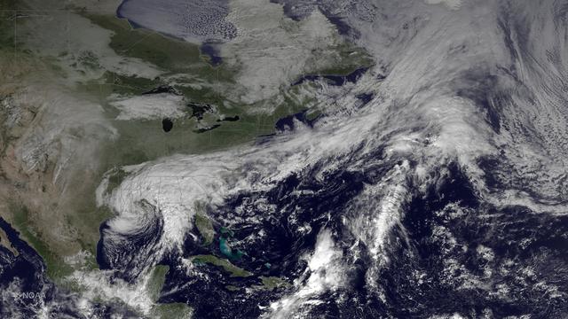
The system that brought heavy rainfall and flash flooding to parts of the southern Plains and western Gulf Coast over the past several days continues to push eastward, with the greatest potential for heavy rain and flash flooding on Monday…
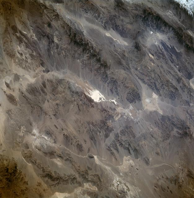
Heavy Rain, Flash Flooding Possible Across Parts of Lower Mississippi Valley, Southeast
SL3-88-004 (July-September 1973) --- A vertical view of the Salinas River Valley area south of Monterey Bay, California area is seen in this Skylab 3 Earth Resources Experiments Package S190-B (five-inch Earth terrain camera) photograph tak…
View of the Salinas River Valley area south of Monterey Bay, California
SL4-93-153 (February 1974) --- A vertical view of the Birmingham and central Alabama area is seen in this Skylab 4 Earth Resources Experiments Package S190-B (five-inch earth terrain camera) infrared photographed taken from the Skylab space…
Birmingham and central Alabama area seen in Earth Resources Exp. Package
NASA systems engineer, Daniel Eng, right, talks with student participants at the 2019 Aerospace Valley Robotics Competition at the Palmdale Aerospace Academy in Palmdale, California.
NASA Systems Engineer Talks with Students at Robotics Competition
View from a NASA aircraft, TG-14, over the Superbloom of yellow wildflowers and orange poppies from the Antelope Valley in Southern California, Poppy Reserve and solar panels are in the background.
Rainy Winter Season Brings Abundance of Wildflowers and Poppies in Southern California’s Antelope Valley. The Poppy is the state flower.
View from a NASA aircraft, TG-14, over the Superbloom of wildflowers and poppies from the Antelope Valley in Southern California and Poppy Reserve and solar panels in background
Rainy Winter Season Brings Abundance of Wildflowers and Poppies in Southern California’s Antelope Valley. The poppy is the state flower.
Masten Space Systems’ technician making adjustments to NASA’s autonomous landing technologies payload on Masten’s Xodiac rocket.
NASA Seeks Research Proposals for Space Technologies to Flight Test
Silicon Valley technology Festival Paco Rafageles, left and Dr Pete Worden, Director Ames Research Center, right sign documents seal it with a hand shake.
ARC-2011-ACD11-0214-009
In this Apollo 17 onboard photo, a Lunar Roving Vehicle (LRV) is parked beside a huge boulder near the Valley of Tourus-Litttrow on the lunar surface. The seventh and last manned lunar landing and return to Earth mission, the Apollo 17, car…
Saturn Apollo Program
This graphic shows the route that NASA's Mars Exploration Rover Opportunity drove in its final approach to 'Perseverance Valley' on the western rim of Endeavour Crater.  The map covers an area about four-tenths of a mile (two-thirds of a ki…
From 'Tribulation' to 'Perseverance' on Mars
Rep. Chuck Fleischmann (R-Tn) being briefed on additive manufacturing at MSFC during a tour of Marshall facilities. Rep. Fleischmann was accompanied by Darrell Akins, Executive Manager of the Tennessee Valley corridor.
Tennessee Representative Chuck Fleischmann Visit to MSFC
STS059-86-059 (9-20 April 1994) --- This oblique handheld Hasselblad 70mm photo shows Death Valley, near California's border with Nevada.  The valley -- the central feature of Death Valley National Monument -- extends north to south for som…
Death Valley California as seen from STS-59
SL4-138-3843 (1 Jan. 1974) --- A part of northern California centered near San Francisco Bay photographed at 3 p.m. Jan. 2, 1974, from the Skylab space station in Earth orbit. This near vertical view encompasses the coastline from Monterey…
Northern California near San Francisco
Pat Gaspard, a visitor relations specialist with NASA's StenniSphere visitor center, speaks to Mississippi Valley State University students. Gaspard spoke July 15 during Stennis Space Center's three-day educational outreach program at the c…
Mississippi Valley State University educational outreach
This map show a portion of Endeavour Crater's western rim that includes the "Marathon Valley" area investigated intensively by NASA's Mars Exploration Rover Opportunity in 2015 and 2016, and a fluid-carved gully that is a destination to the…
From Marathon Valley to Gully on Endeavour Rim
STS059-S-026 (11 April 1994) --- This is an image of Death Valley, California, centered at 36.629 degrees north latitude, 117.069 degrees west longitude.  The image shows Furnace Creek alluvial fan and Furnace Creek Ranch at the far right,…
Death Valley, California
NASA’s T-34 aircraft flown from the agency’s Armstrong Flight Research Center heading toward Southern California’s Antelope Valley Poppy Reserve. The aircraft was flown from the agency’s Armstrong Flight Research Center.
NASA Aircraft heads to Southern California’s Poppy Reserve in the foreground. Rainy Season made the Antelope Valley colorful with poppies and wildflowers.
View from a NASA aircraft, TG-14, over the Superbloom of wildflowers and poppies from the Antelope Valley in Southern California, Poppy Reserve and solar panels are in the background.
Rainy Winter Season Brings Abundance of Wildflowers and Poppies in Southern California’s Antelope Valley. Solar panels are in the background.
View from a NASA aircraft, TG-14, over the Superbloom of yellow wildflowers and orange poppies from the Antelope Valley in Southern California. The poppy is the state flower.
Rainy Winter Season Brings Abundance of Wildflowers and Poppies in Southern California’s Antelope Valley. The poppy is the state flower.
Image from a NASA aircraft, TG-14, over the Superbloom of wildflowers and poppies from the Antelope Valley in Southern California
Rainy Winter Season Brings Abundance of Wildflowers and Poppies in Southern California's Antelope Valley. The poppy is the state flower.
No more images