Taken on October 22, 2015 at 0400 UTC by the Suomi NPP satellite's VIIRS sensor, this colorized infrared image shows the extremely large eye of Typhoon Champi. With a diameter of 60 nautical miles, the eye of the storm is larger than the st…
Typhoon Champi Develops Massive Eye
NASA's Terra satellite captured this visible image on July 9 at 02:30 UTC (July 8 at 10:30 p.m. EDT) as Typhoon Neoguri was approaching Kyushu, Japan.   The visible image revealed that Neoguri's eye had disappeared and the center has become…
Typhoon Neoguri Approaching Japan
With maximum sustained wind speeds of 140 mph, Super Typhoon Utor made landfall in the Philippines on August 11, 2013 around 18:00z. The storm crossed over the island of Luzon and into the South China Sea. The Joint Typhoon Warning Center p…
Super Typhoon Utor Impacts the Philippines
It’s usually the big, sprawling storms that attract the attention of meteorologists, but occasionally tiny storms can make news as well. The most recent example is a suspected mini-typhoon that drifted across the western Pacific Ocean in mi…
"Midget typhoon" in the western Pacific Ocean
NASA's Aqua satellite and RapidScat instrument analyzed Super typhoon Soudelor's extent and winds as it reached Category Five typhoon status on the Saffir-Simpson Wind Scale.  On Aug. 4, 2015, at 4:10 UTC (12:10 a.m. EDT) the MODIS instrume…
NASA Sees Soudelor Reach Category 5 Typhoon Status
In this MODIS image from NASA's Aqua satellite, the eye of Typhoon Soudelor is seen over northwestern Taiwan on August 8, 2015 at 05:25 UTC (1:25 a.m. EDT). At that time, Soudelor had maximum sustained winds near 90 knots. It was less than…
Typhoon Soudelor's Eye over Northwestern Taiwan
Typhoon Chan-Hom's eye was visible from space when NASA's Aqua satellite passed overhead early on July 8, 2015.  The MODIS instrument, known as the Moderate Resolution Imaging Spectrometer, flies aboard NASA's Aqua satellite. When Aqua pass…
Typhoon Chan-Hom "Eyes" NASA's Aqua Satellite
A wet dress rehearsal is underway for Rocket Lab’s Electron rocket at Launch Complex 1 in Mahia, New Zealand on April 28, 2023. NASA’s Time-Resolved Observations of Precipitation structure and storm Intensity with a Constellation of Smallsa…
TROPICS Wet Dress Rehearsal
A wet dress rehearsal is underway for Rocket Lab’s Electron rocket at Launch Complex 1 in Mahia, New Zealand on April 28, 2023. NASA’s Time-Resolved Observations of Precipitation structure and storm Intensity with a Constellation of Smallsa…
TROPICS Wet Dress Rehearsal
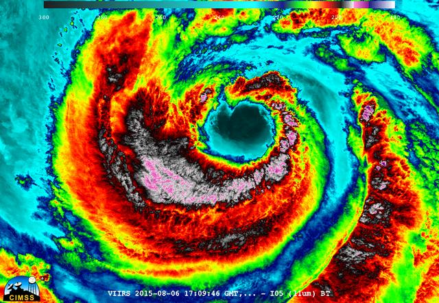
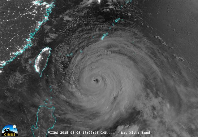
On August 6, 2015, NASA-NOAA's Suomi NPP satellite passed over powerful Typhoon Soudelor when it was headed toward Taiwan.  The Visible Infrared Imaging Radiometer Suite (VIIRS) instrument aboard NASA-NOAA's Suomi satellite captured an infr…
NASA-NOAA's Suomi NPP Gets an Infrared look at Typhoon Soudelor
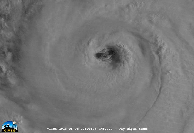
On August 6, 2015, NASA-NOAA's Suomi NPP satellite passed over powerful Typhoon Soudelor when it was headed toward Taiwan.  The Visible Infrared Imaging Radiometer Suite (VIIRS) instrument aboard NASA-NOAA's Suomi satellite captured this ni…
Typhoon Soudelor's Eye Close-Up from NASA-NOAA's Suomi NPP
Technicians place NASA’s Time-Resolved Observations of Precipitation structure and storm Intensity with a Constellation of Smallsats (TROPICS) CubeSats in Rocket Lab’s Electron payload fairing in a processing facility near Launch Complex 1…
TROPICS Encapsulation
Technicians prepare NASA’s Time-Resolved Observations of Precipitation structure and storm Intensity with a Constellation of Smallsats (TROPICS) CubeSats for encapsulation in Rocket Lab’s Electron payload fairing in a processing facility ne…
TROPICS Encapsulation
Rocket Lab’s Electron payload fairing is in view inside a processing facility near Launch Complex 1 in Mahia, New Zealand. NASA’s Time-Resolved Observations of Precipitation structure and storm Intensity with a Constellation of Smallsats (T…
TROPICS Encapsulation
Technicians check Rocket Lab’s Electron payload fairing inside a processing facility near Launch Complex 1 in Mahia, New Zealand. NASA’s Time-Resolved Observations of Precipitation structure and storm Intensity with a Constellation of Small…
TROPICS Encapsulation
On Sept. 21, Typhoon Usagi was moving between the northern Philippines and Taiwan when NASA's Aqua satellite passed overhead. NASA's AIRS instrument that flies aboard the Aqua satellite captured this near-infrared image on Sept. 21 at 505 U…
Near-Infrared Image of Typhoon Usagi Between Taiwan and the Philippines
NASA image captured Oct. 18, 2010 at 02:35 UTC  Typhoon Megi (15W) over the Philippines.  The Moderate Resolution Imaging Spectroradiometer (MODIS) on NASA’s Terra satellite at 10:35 a.m. Philippine Time (02:35 UTC) on October 18, 2010. Meg…
NASA's Terra Satellite Catches Powerful Supertyphoon Megi
The MODIS instrument on NASA's Terra satellite captured Typhoon Neoguri in the Pacific Ocean at 02:05 UTC (10:05 PM EDT) on July 6, 2014.  Typhoon Neoguri is expected to reach Okinawa early Tuesday, bringing sustained winds of 198 kilometer…
Typhoon Neoguri
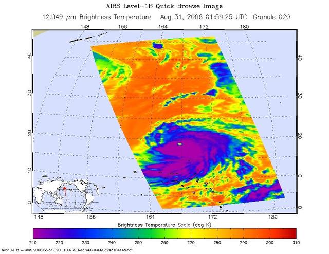
This infrared image shows Typhoon Ioke in the Western Pacific, from the Atmospheric Infrared Sounder AIRS on NASA Aqua satellite in August, 2006.  Because infrared radiation does not penetrate through clouds, AIRS infrared images show eithe…
Typhoon Ioke in the Western Pacific
The MODIS instrument aboard NASA's Aqua satellite flew over Typhoon Soudelor on Aug. 7, 2015, at 4:40 UTC (12:40 a.m. EDT) as it was approaching Taiwan.  Credits: NASA Goddard's MODIS Rapid Response Team  Clouds in Typhoon Soudelor's wester…
NASA Sees a Wider-Eyed Typhoon Soudelor Near Taiwan
On July 9 at 02:05 UTC (July 8 at 10:05 p.m. EDT) the MODIS instrument aboard NASA's Terra satellite captured an image of Typhoon Chan-Hom east of Taiwan. The image clearly showed an eye with powerful bands of thunderstorms spiraling into t…
NASA Sees Typhoon Chan-Hom's Strongest Winds in Northern and Eastern Quadrants
Over the weekend of Oct. 5 and 6, Typhoon Phanfone's center made landfall just south of Tokyo and passed over the city before exiting back into the Northwestern Pacific Ocean. NASA's Aqua satellite captured a picture of the typhoon as Tokyo…
NASA Spots Typhoon Phanfone Affecting Japan
The MODIS instrument aboard NASA's Aqua satellite captured this visible image of Super Typhoon Vongfong on Oct. 9 at 04:25 UTC (12:25 a.m. EDT as it moved north through the Philippine Sea.  Credit: NASA Goddard MODIS Rapid Response Team   -…
NASA's Aqua Satellite Tracking Super Typhoon Vongfong
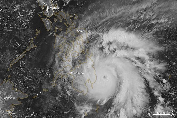
NASA image acquired December 3, 2012  As predicted, Typhoon Bopha made landfall on the Philippine island of Mindanao overnight December 3–4, 2012. Known in the Philippines as Pablo, the storm was blamed for 43 deaths and 25 injuries as of D…
Typhoon Bopha Makes Landfall
With the umbilical tower in view, Rocket Lab’s Electron rocket is vertical on the pad at Launch Complex 1 in Mahia, New Zealand. NASA’s Time-Resolved Observations of Precipitation structure and storm Intensity with a Constellation of Smalls…
TROPICS - Rocket Vertical on Pad
Rocket Lab’s Electron rocket is vertical on the pad at Launch Complex 1 in Mahia, New Zealand. NASA’s Time-Resolved Observations of Precipitation structure and storm Intensity with a Constellation of Smallsats (TROPICS) CubeSats are secured…
TROPICS - Rocket Vertical on Pad
On August 6, 2015, NASA-NOAA's Suomi NPP satellite passed over powerful Typhoon Soudelor at night when it was headed toward Taiwan. The Visible Infrared Imaging Radiometer Suite (VIIRS) instrument aboard NASA-NOAA's Suomi satellite captured…
A Night-time Look at Typhoon Soudelor from NASA-NOAA's Suomi NPP Satellite
Rocket Lab’s Electron payload fairing is in view inside a processing facility near Launch Complex 1 in Mahia, New Zealand. NASA’s Time-Resolved Observations of Precipitation structure and storm Intensity with a Constellation of Smallsats (T…
TROPICS Encapsulation
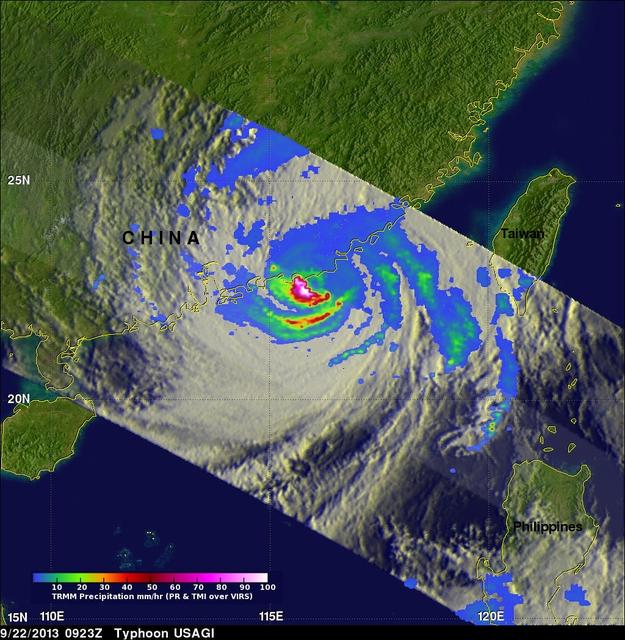
On Saturday, Sept. 21, TRMM captured rainfall data on Typhoon Usagi as it passed between the northern Philippines and southern Taiwan. TRMM found rain falling at a rate of over 134 mm/hr (~5.2 inches) in USAGI's eye wall.   Credit: SSAI/NAS…
Typhoon Usagi approaching China
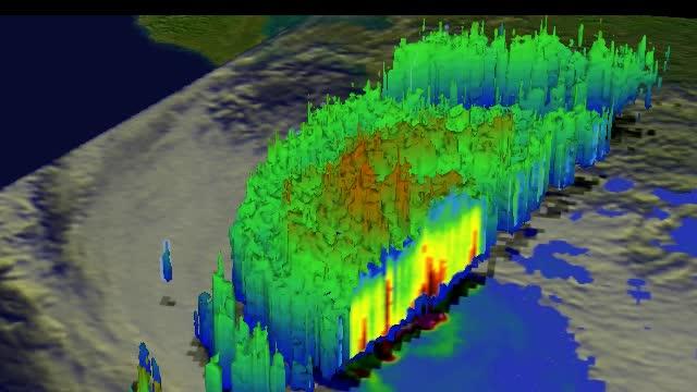
This simulated 3-D flyby animation over Typhoon Usagi on Sept. 22 at 0923 UT showed heavy rain south of the center a rate of over 169mm/~6.7 inches per hour along China's coast. Cloud heights of some thunderstorms were reaching only about 1…
Typhoon Usagi approaching China
The Moderate Resolution Imaging Spectroradiometer or MODIS instrument that flies aboard NASA's Terra satellite captured this image of Typhoon Usagi on Sept. 22 at 02:45 UTC/Sept. 21 at 10:45 p.m. EDT on its approach to a landfall in China.…
Typhoon Usagi approaching China
Supertyphoon Yuri began development approximately 1000 miles east of the Philippine Islands. At the time this photo was taken, Yuri was about 1000 nautical miles in diameter and had estimated maximum sustained wind speeds of 145 mph, gustin…
Supertyphoon Yuri, Western Pacific Ocean
51I-35-075 (30 Aug 1985)  --- Typhoon Pat was photographed on the morning of August 30th at a position of approximately 25 degrees N, 131 degrees E. Stereoscopically-overlapping photographs taken by the 51I crew provide much more detail of…
Typhoon Pat, western Pacific
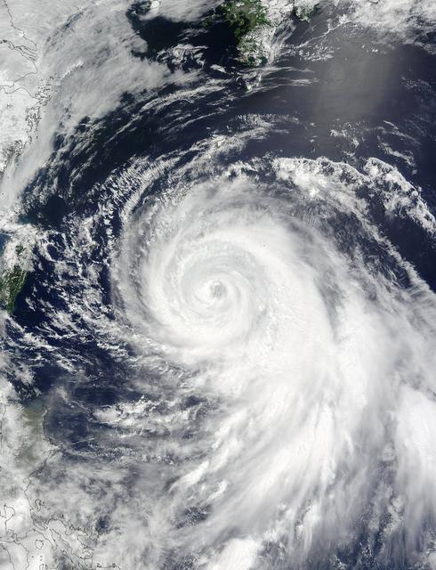
NASA's Terra satellite captured this image of Typhoon Phanfone and its large eye in the western Pacific Ocean on Friday, Oct. 3 at 1:55 UTC.  On Oct. 3 at 0900 UTC (5 a.m. EDT), Typhoon Phanfone's maximum sustained winds were near 110 knots…
Typhoon Phanfone's Large Eye
On Sept. 14, 2016, the eye of Super Typhoon Meranti passed just south of Taiwan. The enormous storm, classified as a Category 5 typhoon at the time, still caused much disruption on the island. Nearly 500,000 homes lost power, schools were c…
Huge Super Typhoon Meranti Over Taiwan Spotted by NASA MISR
The MODIS instrument on NASA's Aqua satellite captured Typhoon Neoguri in the East China Sea at 05:00 UTC (1:00 AM EDT) on July 8, 2014.  Typhoon Neoguri hit Japan’s Okinawa islands on Tuesday local time (July 8, 2014), bringing high winds,…
Typhoon Neoguri in the East China Sea
On August 9 at 03:00 UTC (Aug. 8 at 11 p.m. EDT) the MODIS instrument aboard NASA's Terra satellite passed over the remnant clouds of Typhoon Soudelor when it was over eastern China.    By 22:35 UTC (6:35 p.m. EDT) on August 8, 2015, Typhoo…
NASA Sees Typhoon Soudelor's Remnants Over Eastern China
On Dec. 4 at 02:10 UTC, the MODIS instrument aboard NASA's Terra satellite took this visible image of Super Typhoon Hagupit approaching the Philippines.  Image Credit:  NASA Goddard's MODIS Rapid Response Team  Read more: <a href="http://1.…
NASA Observes Super Typhoon Hagupit; Philippines Under Warnings
With the umbilical tower in view, Rocket Lab’s Electron rocket is vertical on the pad at Launch Complex 1 in Mahia, New Zealand. NASA’s Time-Resolved Observations of Precipitation structure and storm Intensity with a Constellation of Smalls…
TROPICS - Rocket Vertical on Pad
Typhoon Kilo continues to thrive in the Northwestern Pacific and imagery from NASA's Terra satellite late on September 7 showed that the storm still maintained a clear eye.  The MODIS or Moderate Resolution Imaging Spectroradiometer instrum…
NASA Sees Typhoon Kilo Maintaining its Eye
Rocket Lab’s Electron rocket is vertical on the pad at Launch Complex 1 in Mahia, New Zealand. NASA’s Time-Resolved Observations of Precipitation structure and storm Intensity with a Constellation of Smallsats (TROPICS) CubeSats are secured…
TROPICS - Rocket Vertical on Pad
A wet dress rehearsal is underway for Rocket Lab’s Electron rocket at Launch Complex 1 in Mahia, New Zealand on April 28, 2023. NASA’s Time-Resolved Observations of Precipitation structure and storm Intensity with a Constellation of Smallsa…
TROPICS Wet Dress Rehearsal
On August 6, 2015, NASA-NOAA's Suomi NPP satellite passed over powerful Typhoon Soudelor when it was headed toward Taiwan.  The Visible Infrared Imaging Radiometer Suite (VIIRS) instrument aboard NASA-NOAA's Suomi satellite captured this ni…
Typhoon Soudelor's Eye Close-Up from NASA-NOAA's Suomi NPP
On Nov. 10 at 03:30 UTC/Nov. 9 at 10:30 p.m. EDT, the MODIS instrument aboard NASA's Terra satellite showed the center of Typhoon Haiyan just south of Hainan Island, China in the South China Sea.   Credit: NASA Goddard MODIS Rapid Response…
Typhoon Haiyan Near Hainan Island, China
On Sept. 22 at 0923 UTC/5:23 a.m. EDT,  just south of Usagi's eye where rain was falling at a rate of over 169mm/~6.7 inches per hour along China's coast.  TRMM radar sliced through Usagi and found that heights of some thunderstorms were re…
Typhoon Usagi approaching China
NASA’s Time-Resolved Observations of Precipitation structure and storm Intensity with a Constellation of Smallsats (TROPICS) CubeSats are encapsulated inside Rocket Lab’s Electron payload fairing in a processing facility near Launch Complex…
TROPICS Encapsulation
This detailed view of the eye of Supertyphoon Yuri (19.0N, 140.0E) shows the bowl shaped structure of the eye wall. The eye cylinder descends almost to the ocean surface, some 45,000 to 50,000 ft. In this case, the eye is filled with clouds…
Eye of Supertyphoon Yuri
NASA satellite imagery from July 10 revealed a very clear and cloudless eye in the Northwestern Pacific’s Typhoon Soulik as it moves toward a landfall in China by the end of the week.  The Moderate Resolution Imaging Spectroradiometer (MODI…
NASA Gets an Eye-Opening Look at Typhoon Soulik