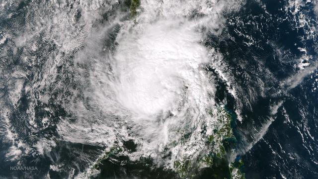
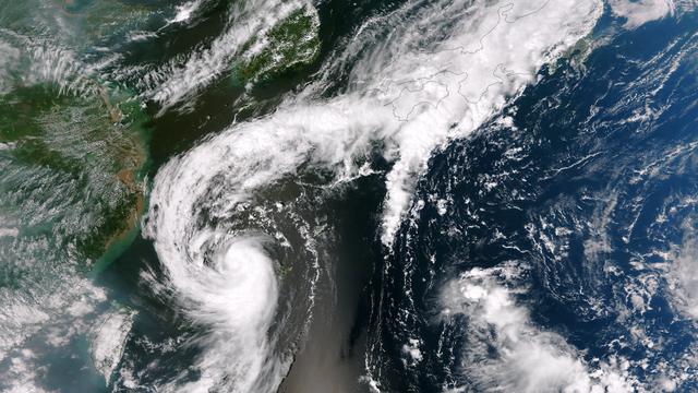
On Nov. 11 at 05:45 UTC, the MODIS instrument aboard NASA's Aqua satellite captured this image of Tropical Storm Haiyan over mainland China.   Credit: NASA Goddard MODIS Rapid Response Team   <b><a href="http://www.nasa.gov/audience/formedi…
Tropical Storm Haiyan Makes Landfall in Northern Vietnam
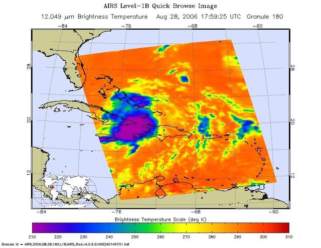
This infrared image shows Tropical Storm Ernesto over Cuba, from the Atmospheric Infrared Sounder AIRS on NASA Aqua satellite in August, 2006. Because infrared radiation does not penetrate through clouds, AIRS infrared images show either th…
Tropical Storm Ernesto over Cuba
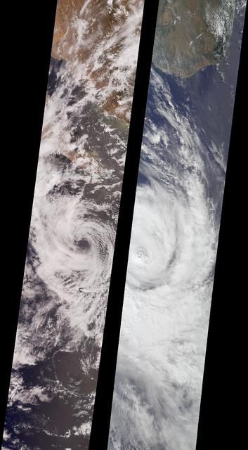
Like dancers pirouetting in opposite directions, the rotational patterns of two different tropical storms are contrasted in this pair of MISR nadir-camera images.  The left-hand image is of Tropical Storm Bud, acquired on June 17, 2000 (Ter…
Tropical Storms Bud and Dera
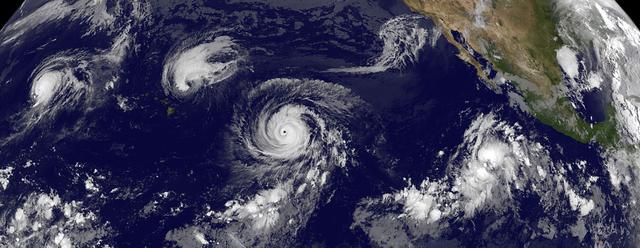
This GOES-West satellite image shows four tropical cyclones in the North Western, Central and Eastern Pacific Ocean on September 1, 2015. In the Western Pacific (far left) is Typhoon Kilo. Moving east (to the right) into the Central Pacific…
Four Tropical Cyclones Across the Entire Pacific Ocean
Rocket Lab’s Electron rocket is vertical on the pad at Launch Complex 1 in Mahia, New Zealand. NASA’s Time-Resolved Observations of Precipitation structure and storm Intensity with a Constellation of Smallsats (TROPICS) CubeSats are secured…
TROPICS - Rocket Vertical on Pad
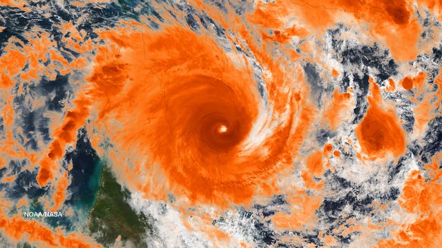
Residents of the northeast coast of Queensland, Australia are facing high winds, dangerous tides and very heavy rain between Cape Melville and Cooktown. These hazards will migrate southward for the next few days as the center of the storm r…
Tropical Cyclone Ita Off-Shore Queensland, Australia
Rocket Lab’s Electron rocket is vertical on the pad at Launch Complex 1 in Mahia, New Zealand. NASA’s Time-Resolved Observations of Precipitation structure and storm Intensity with a Constellation of Smallsats (TROPICS) CubeSats are secured…
TROPICS - Rocket Vertical on Pad
On Nov. 9 at 05:55 UTC/12:55 a.m. EDT, Typhoon Haiyan was in the middle of the South China Sea, headed toward Vietnam.   Credit: NASA Goddard MODIS Rapid Response Team   <b><a href="http://www.nasa.gov/audience/formedia/features/MP_Photo_Gu…
Haiyan After Moving Through the Philippines
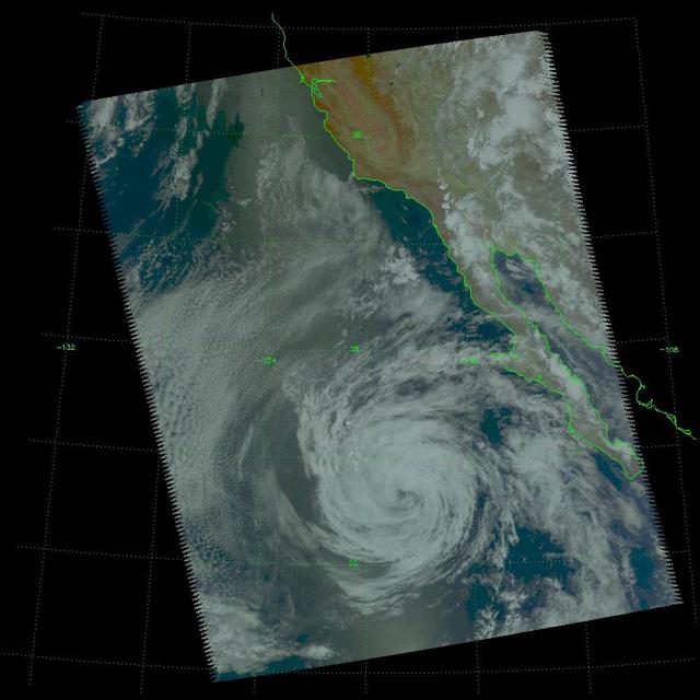
This visible image of Tropical Storm Miriam was captured by NOAA's GOES-15 satellite on Sept. 26, 2012 at 10:45 a.m. EDT off the coast of Baja California. The strongest thunderstorms were in a large band of thunderstorms north and northwest…
Satellite Sees Miriam Weaken to a Tropical Storm
NASA image acquired January 26,02011  Tropical Cyclone Wilma raged over the Pacific Ocean in late January 2011. At 8:00 p.m. New Caledonia time (9:00 UTC) on January 26, the U.S. Navy’s Joint Typhoon Warning Center (JTWC) reported that Wilm…
Tropical Cyclone Wilma off Fiji
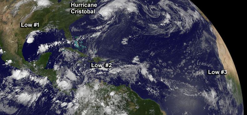
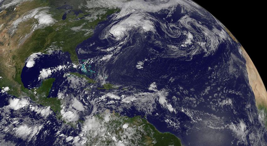
Although there's only one formed tropical cyclone in the Atlantic: Hurricane Cristobal, there are three other developing areas of low pressure and all were captured in this panoramic image from NOAA's GOES-East satellite today at 8 a.m. EDT…
Satellite Sees a Hyperactive Tropical Atlantic [annotated]
Technicians check Rocket Lab’s Electron payload fairing inside a processing facility near Launch Complex 1 in Mahia, New Zealand. NASA’s Time-Resolved Observations of Precipitation structure and storm Intensity with a Constellation of Small…
TROPICS Encapsulation
Tropical Cyclone Glenda took a five day tour of the Southern Indian Ocean in late February, 2015. The storm formed from a low pressure system, System 90S on February 24, when maximum sustained winds reached 40 mph (64 km/h).  The Moderate R…
Tropical Cyclone Glenda in the Indian Ocean
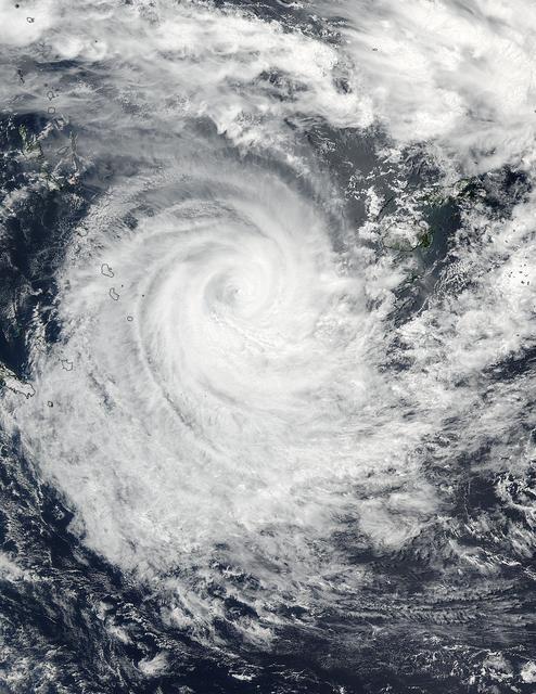
NASA-NOAA's Suomi NPP satellite saw that Tropical Cyclone Winston maintained a pinhole eye as it tracked east of southern Vanuatu's islands in the Southern Pacific Ocean on Feb. 23. Infrared imagery showed bands of strong thunderstorms were…
NASA Sees Pinhole Eye Seen in Weakening Tropical Cyclone Winston
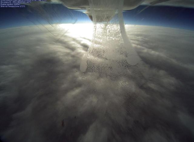
NASA's Global Hawk flew over Tropical Storm Nadine on Sept. 26, 2012 at 3 p.m. EDT and captured this photo from the camera located in the belly if the aircraft as it flew over the northern edge of the storm. Credit: NASA  <b><a href="http:/…
NASA's Global Hawk Flies Over Tropical Storm Nadine
NASA and NOAA satellites are studying the triple tropical tempests that are now romping through the Eastern Pacific Ocean. NOAA's GOES-West satellite captured Tropical Storm Karina, Tropical Storm Lowell and newly formed Tropical Storm Mari…
A Triple Tropical Tempest Train: Karina, Lowell, Mariest
Tropical Storm Blas as observed by the Atmospheric Infrared Sounder AIRS onboard NASA Aqua in the year 2004. The major contribution to radiation (infrared light) that AIRS channels sense comes from different levels in the atmosphere, depend…
Tropical Storm Blas off the Pacific Coast of Mexico
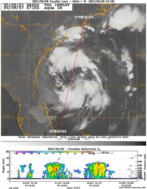
CloudSat's Cloud Profiling Radar captured a profile across Tropical Storm Andrea on Wednesday, May 9, 2007, near the South Carolina/Georgia/Florida Atlantic coast. The upper image shows an infrared view of Tropical Storm Andrea from the Mod…
CloudSat Profiles Tropical Storm Andrea
Tropical Storm Toraji Approaching Japan, 09/03/2013 at 02:10 UTC.  Terra/MODIS  <b><a href="http://www.nasa.gov/audience/formedia/features/MP_Photo_Guidelines.html" rel="nofollow">NASA image use policy.</a></b>  <b><a href="http://www.nasa.…
Tropical Storm Toraji Approaching Japan
With the umbilical tower in view, Rocket Lab’s Electron rocket is vertical on the pad at Launch Complex 1 in Mahia, New Zealand. NASA’s Time-Resolved Observations of Precipitation structure and storm Intensity with a Constellation of Smalls…
TROPICS - Rocket Vertical on Pad
Tropical Storm Hagupit's low level circulation center is being obscured by its deep central convection and intensities are hard to pinpoint as the storm interacts with land. Once clear over the waters of the South China Sea Hagupit is forec…
Tropical Storm Hagupit Weakening as it Nears Manila
With the umbilical tower in view, Rocket Lab’s Electron rocket is vertical on the pad at Launch Complex 1 in Mahia, New Zealand. NASA’s Time-Resolved Observations of Precipitation structure and storm Intensity with a Constellation of Smalls…
TROPICS - Rocket Vertical on Pad
A wet dress rehearsal is underway for Rocket Lab’s Electron rocket at Launch Complex 1 in Mahia, New Zealand on April 28, 2023. NASA’s Time-Resolved Observations of Precipitation structure and storm Intensity with a Constellation of Smallsa…
TROPICS Wet Dress Rehearsal
On Nov. 10 at 03:30 UTC/Nov. 9 at 10:30 p.m. EDT, the MODIS instrument aboard NASA's Terra satellite showed the center of Typhoon Haiyan just south of Hainan Island, China in the South China Sea.   Credit: NASA Goddard MODIS Rapid Response…
Typhoon Haiyan Near Hainan Island, China
Technicians prepare NASA’s Time-Resolved Observations of Precipitation structure and storm Intensity with a Constellation of Smallsats (TROPICS) CubeSats for encapsulation in Rocket Lab’s Electron payload fairing in a processing facility ne…
TROPICS Encapsulation
On Nov. 3, 2015 at 07:20 UTC (2:20 a.m. EDT) the MODIS instrument aboard NASA's Aqua satellite captured this image of Tropical Cyclone Chapala over Yemen.  Credit: NASA Goddard MODIS Rapid Response Team  <b><a href="http://www.nasa.gov/audi…
NASA Sees First Land-falling Tropical Cyclone in Yemen
NASA’s Time-Resolved Observations of Precipitation structure and storm Intensity with a Constellation of Smallsats (TROPICS) CubeSats are encapsulated inside Rocket Lab’s Electron payload fairing in a processing facility near Launch Complex…
TROPICS Encapsulation
Tropical Cyclone Debbie made landfall in Queensland bringing heavy rainfall, hurricane-force winds, rough seas, and flooding. NASA-NOAA's Suomi NPP satellite provided a visible look at the storm from space while NASA's Aqua satellite analyz…
NASA Sees Tropical Cyclone Debbie Make Landfall in Queensland
NASA image acquired January 28, 2011  Tropical Cyclone Bianca continued moving southward along the coast of Western Australia on January 28, 2011. At 5:00 a.m. on January 28 local time (21:00 UTC on January 27), the U.S. Navy’s Joint Typhoo…
Tropical Cyclone Bianca
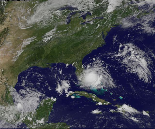
Radar and satellite imagery indicate that the convective organization of the cyclone has improved, and the cyclone is being upgraded based on a sustained wind report of 33 kt from Settlement Point, Grand Bahama Island earlier this morning.…
Tropical Storm Arthur Forms
NASA image acquired August 10, 2010  Tropical Storm Dianmu blew over the East China Sea in early August 2010, traveling slowly toward the Korean Peninsula. On August 10, 2010, the U.S. Navy’s Joint Typhoon Warning Center (JTWC) reported tha…
Tropical Storm Dianmu
Image acquired February 19, 2010:  Tropical Cyclone Gelane had sustained winds of 125 knots (230 kilometers per hour) and gusts up to 150 knots (275 kilometers per hour), according to a report from the U.S. Navy’s Joint Typhoon Warning Cent…
Tropical Cyclone Gelane
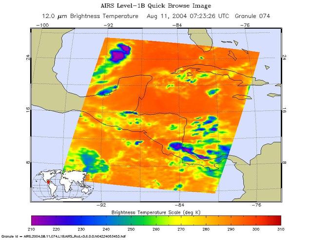
Tropical storm Bonnie, Gulf of Mexico, captured on August 11 at 1:30am CDT. Located in the Gulf of Mexico, the center of the storm is positioned about 280 miles south-southwest of the mouth of the Mississippi River. Bonnie is a small tropic…
Tropical Storm Bonnie as Observed by NASA Spaceborne Atmospheric Infrared Sounder AIRS
NASA Gets a Last Look at Post-Tropical Cyclone Matthew Before It was Swallowed Up  Post-Tropical Cyclone Matthew was swallowed up or absorbed by a cold front on Oct. 10, but NASA's Terra satellite captured a last look at the storm before th…
Post-Tropical Cyclone Matthew
It is easy to see the effect of the strong northeasterly wind shear battering Tropical Storm Gaemi in satellite imagery from NASA. This true-color image acquired on Oct. 5 shows a large oval-shaped area of showers and thunderstorms associat…
Tropical Storm Gaemi approaching Vietnam
At about 6:00 a.m. EDT (10:00 UTC) on May 10, 2015, Tropical Storm Ana made landfall between Myrtle Beach and North Myrtle Beach, South Carolina. One day earlier, on the morning of May 9, the Moderate Resolution Imaging Spectroradiometer (M…
Tropical Storm Ana off the Carolinas
The outflow from Tropical Storm Toraji spawned tornadoes that caused injuries and property damage in Koshigaya, Saitama Prefecture, Japan, just northeast of Tokyo, on September 2, 2013. This image was taken by the Suomi NPP satellite's VIIR…
Tropical Storm Toraji Spawns Tornadoes in Japan
A wet dress rehearsal is underway for Rocket Lab’s Electron rocket at Launch Complex 1 in Mahia, New Zealand on April 28, 2023. NASA’s Time-Resolved Observations of Precipitation structure and storm Intensity with a Constellation of Smallsa…
TROPICS Wet Dress Rehearsal
A wet dress rehearsal is underway for Rocket Lab’s Electron rocket at Launch Complex 1 in Mahia, New Zealand on April 28, 2023. NASA’s Time-Resolved Observations of Precipitation structure and storm Intensity with a Constellation of Smallsa…
TROPICS Wet Dress Rehearsal
Rocket Lab’s Electron payload fairing is in view inside a processing facility near Launch Complex 1 in Mahia, New Zealand. NASA’s Time-Resolved Observations of Precipitation structure and storm Intensity with a Constellation of Smallsats (T…
TROPICS Encapsulation
Technicians place NASA’s Time-Resolved Observations of Precipitation structure and storm Intensity with a Constellation of Smallsats (TROPICS) CubeSats in Rocket Lab’s Electron payload fairing in a processing facility near Launch Complex 1…
TROPICS Encapsulation
Rocket Lab’s Electron payload fairing is in view inside a processing facility near Launch Complex 1 in Mahia, New Zealand. NASA’s Time-Resolved Observations of Precipitation structure and storm Intensity with a Constellation of Smallsats (T…
TROPICS Encapsulation
On June 15 at 19:15 UTC (3:15 p.m. EDT) the MODIS instrument aboard NASA's Aqua satellite captured a visible image of Tropical Storm Bill approaching Texas and Louisiana. Powerful thunderstorms circled the center in fragmented bands.  At 11…
NASA Sees Tropical Storm Bill Making Landfall in Texas
NASA image acquired January 28, 2011  High res file here: <a href="http://www.flickr.com/photos/gsfc/5400445475">www.flickr.com/photos/gsfc/5400445475</a>  Tropical Cyclone Bianca continued moving southward along the coast of Western Austra…
Tropical Cyclone Bianca [detail]
NASA's Aqua satellite captured a picture of Tropical Storm Linfa in the South China Sea on July 7 when it was between southern Taiwan and the northern Philippines.  Aqua passed over Linfa on July 7 at 05:25 UTC (1:25 a.m. EDT) and the Moder…
NASA Sees Tropical Storm Linfa Between Taiwan and Northern Philippines
This is a satellite image from the MODIS instrument aboard NASA's Terra satellite of Tropical Storm Andrea that was captured today, June 7 at 12:10 p.m. EDT- as Andrea makes its way up the U.S. East coast. At this time, Andrea was centered…
NASA's Terra satellite of Tropical Storm Andrea
Although there's only one formed tropical cyclone in the Atlantic: Hurricane Cristobal, there are three other developing areas of low pressure and all were captured in this panoramic image from NOAA's GOES-East satellite today at 8 a.m. EDT…
Satellite Sees a Hyperactive Tropical Atlantic
NASA image acquired August 28, 2012  Early on August 28, 2012, the Visible Infrared Imaging Radiometer Suite (VIIRS) on the Suomi-NPP satellite captured this nighttime view of Tropical Storm Isaac and the cities near the Gulf Coast of the U…
Tropical Storm Isaac by Night