Mr. Lai Chien-Hsin Director General of Taiwan's Water Resources Agency and staff of US Bureau of Reclamation visited Goddard November 15, 2018 They toured facilties such as Hyperwall - Stephanie Uz
In this MODIS image from NASA's Aqua satellite, the eye of Typhoon Soudelor is seen over northwestern Taiwan on August 8, 2015 at 05:25 UTC (1:25 a.m. EDT). At that time, Soudelor had maximum sustained winds near 90 knots. It was less than…
On August 9 at 03:00 UTC (Aug. 8 at 11 p.m. EDT) the MODIS instrument aboard NASA's Terra satellite passed over the remnant clouds of Typhoon Soudelor when it was over eastern China. By 22:35 UTC (6:35 p.m. EDT) on August 8, 2015, Typhoo…
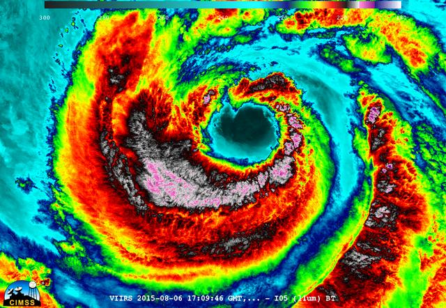
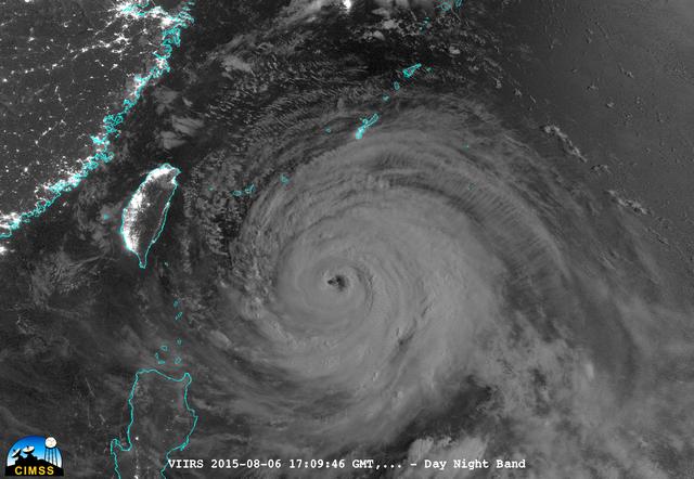
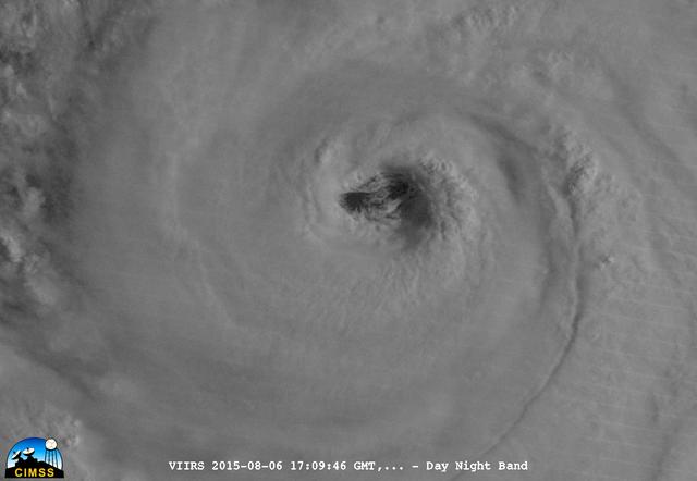
On August 6, 2015, NASA-NOAA's Suomi NPP satellite passed over powerful Typhoon Soudelor when it was headed toward Taiwan. The Visible Infrared Imaging Radiometer Suite (VIIRS) instrument aboard NASA-NOAA's Suomi satellite captured this ni…
Mr. Lai Chien-Hsin, Director Genreal of Taiwan’s Water Resources Agency and staff US Bureau of Reclamation visited Goddard November 15, 2018 They toured Hyperwall and Earth Sciences facilities
NASA's Aqua satellite captured a picture of Tropical Storm Linfa in the South China Sea on July 7 when it was between southern Taiwan and the northern Philippines. Aqua passed over Linfa on July 7 at 05:25 UTC (1:25 a.m. EDT) and the Moder…
On August 6, 2015, NASA-NOAA's Suomi NPP satellite passed over powerful Typhoon Soudelor when it was headed toward Taiwan. The Visible Infrared Imaging Radiometer Suite (VIIRS) instrument aboard NASA-NOAA's Suomi satellite captured an infr…
On August 6, 2015, NASA-NOAA's Suomi NPP satellite passed over powerful Typhoon Soudelor at night when it was headed toward Taiwan. The Visible Infrared Imaging Radiometer Suite (VIIRS) instrument aboard NASA-NOAA's Suomi satellite captured…
The MODIS instrument aboard NASA's Aqua satellite flew over Typhoon Soudelor on Aug. 7, 2015, at 4:40 UTC (12:40 a.m. EDT) as it was approaching Taiwan. Credits: NASA Goddard's MODIS Rapid Response Team Clouds in Typhoon Soudelor's wester…
On Sept. 21, Typhoon Usagi was moving between the northern Philippines and Taiwan when NASA's Aqua satellite passed overhead. NASA's AIRS instrument that flies aboard the Aqua satellite captured this near-infrared image on Sept. 21 at 505 U…
On August 6, 2015, NASA-NOAA's Suomi NPP satellite passed over powerful Typhoon Soudelor when it was headed toward Taiwan. The Visible Infrared Imaging Radiometer Suite (VIIRS) instrument aboard NASA-NOAA's Suomi satellite captured this ni…