
This graphic indicates a similarity between 2016 (dark blue line) and five past years in which Mars has experienced a global dust storm (orange lines and band), compared to years with no global dust storm (blue-green lines and band). The ar…
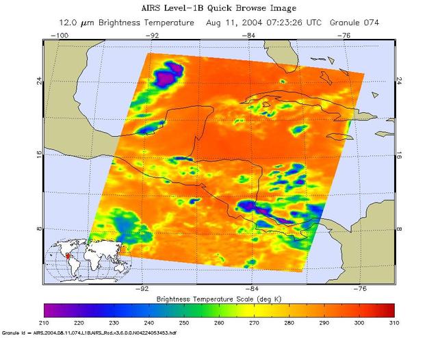
Tropical storm Bonnie, Gulf of Mexico, captured on August 11 at 1:30am CDT. Located in the Gulf of Mexico, the center of the storm is positioned about 280 miles south-southwest of the mouth of the Mississippi River. Bonnie is a small tropic…
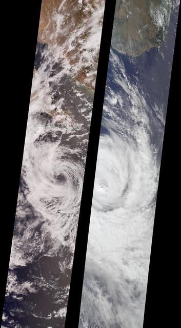
Like dancers pirouetting in opposite directions, the rotational patterns of two different tropical storms are contrasted in this pair of MISR nadir-camera images. The left-hand image is of Tropical Storm Bud, acquired on June 17, 2000 (Ter…

KENNEDY SPACE CENTER, FLA. - The Damage Assessment Recovery Team (DART) meets at the NASA KSC News Center following Hurricane Jeanne. At left (red shirt) is Center Director Jim Kennedy and Media Services Division Chief Mike Rein. A catego…

KENNEDY SPACE CENTER, FLA. - An aerial view of the Vehicle Assembly Building at KSC shows damage to the roof inflicted by both Hurricane Frances and the category 3 Hurricane Jeanne. The latter storm barreled through Central Florida Sept. 2…

KENNEDY SPACE CENTER, FLA. - A view of the Vehicle Assembly Building at KSC shows damage inflicted by both Hurricane Frances and the category 3 Hurricane Jeanne. The storm barreled through Central Florida Sept. 25-26 from the southeast. T…

The monster winter storm that brought icing to the U.S. southeast moved northward along the Eastern Seaboard and brought snow, sleet and rain from the Mid-Atlantic to New England on February 13. A new image from NOAA's GOES satellite showed…
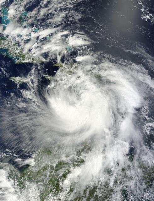
NASA's Terra satellite passed over Tropical Storm Isaac on Aug. 24 at 15:20 UTC (11:20 a.m. EDT) as it continued moving through the eastern Caribbean Sea. The MODIS instrument onboard Aqua captured this visible image. At 2 p.m. EDT on Aug…

STS-65 Earth observation of Hurricane Emilia in Pacific Ocean was taken aboard Columbia, Orbiter Vehicle (OV) 102. This vertical view, photographed with a handheld 70mm camera, reveals the well-defined eye of the hurricane as it moves weste…

Using the Solar Vector Magnetograph, a solar observation facility at NASA's Marshall Space Flight Center (MSFC), scientists from the National Space Science and Technology Center (NSSTC) in Huntsville, Alabama, are monitoring the explosive p…
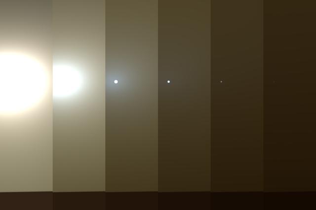
This series of images shows simulated views of a darkening Martian sky blotting out the Sun from NASA's Opportunity rover's point of view, with the right side simulating Opportunity's current view in the global dust storm (June 2018). The l…

KENNEDY SPACE CENTER, FLA. - Center Director James Kennedy (center) prepares to board a helicopter to observe damage from Hurricane Jeanne. A category 3 storm, Jeanne barreled through Central Florida Sept. 25-26, the fourth hurricane in 6…

CAPE CANAVERAL, Fla. – The United Launch Alliance Atlas V rocket with the Radiation Belt Storm Probes, or RBSP, spacecraft aboard is readied for rollout to the launch pad at Space Launch Complex 41 at Cape Canaveral Air Force Station. NASA…
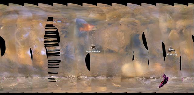
This set of images from NASA's Mars Reconnaissance Orbiter (MRO) shows a fierce, giant dust storm is kicking up on Mars, with rovers on the surface indicated as icons. The spread of the storm can be seen in the salmon-colored overlay. These…
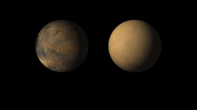
The view from May shows Valles Marineris chasms (left), Meridiani center, an autumn dust storm in Acidalia (top) and the early spring south polar cap (bottom). The view from July shows the same regions, but most of the surface was obscured…
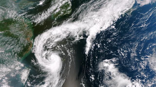
The outflow from Tropical Storm Toraji spawned tornadoes that caused injuries and property damage in Koshigaya, Saitama Prefecture, Japan, just northeast of Tokyo, on September 2, 2013. This image was taken by the Suomi NPP satellite's VIIR…

On Nov. 11 at 05:45 UTC, the MODIS instrument aboard NASA's Aqua satellite captured this image of Tropical Storm Haiyan over mainland China. Credit: NASA Goddard MODIS Rapid Response Team <b><a href="http://www.nasa.gov/audience/formedi…
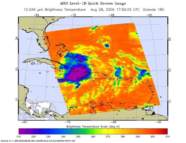
This infrared image shows Tropical Storm Ernesto over Cuba, from the Atmospheric Infrared Sounder AIRS on NASA Aqua satellite in August, 2006. Because infrared radiation does not penetrate through clouds, AIRS infrared images show either th…

This shot from the NASA/ESA Hubble Space Telescope shows a maelstrom of glowing gas and dark dust within one of the Milky Way’s satellite galaxies, the Large Magellanic Cloud (LMC). This stormy scene shows a stellar nursery known as N159,…

KENNEDY SPACE CENTER, FLA. - An aerial view of the Vehicle Assembly Building at KSC shows damage to the roof inflicted by both Hurricane Frances and the category 3 Hurricane Jeanne. The latter storm barreled through Central Florida Sept. 2…

KENNEDY SPACE CENTER, FLA. - An aerial view of the damage to Hangar S at Cape Canaveral Air Force Station by Hurricane Jeanne. A category 3 storm, Jeanne barreled through Central Florida Sept. 25-26, the fourth hurricane in 6 weeks to bat…

At about 6:00 a.m. EDT (10:00 UTC) on May 10, 2015, Tropical Storm Ana made landfall between Myrtle Beach and North Myrtle Beach, South Carolina. One day earlier, on the morning of May 9, the Moderate Resolution Imaging Spectroradiometer (M…
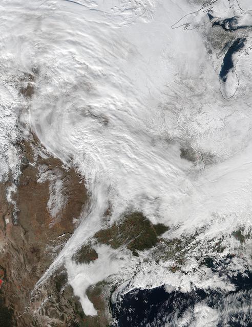
On Jan. 20 at 2:30 p.m. EST the VIIRS instrument aboard NASA-NOAA's Suomi NPP captured this image of the winter storm moving through the central U.S. Credits: NASA Goddard Rapid Response The low pressure area from the Eastern Pacific Ocea…

NASA-NOAA's Suomi NPP satellite passed over the large low pressure area on January 22 at 1855 UTC (1:55 p.m. EST) that stretched from New England south to Florida. Credit: Credits: NASA/NOAA/Goddard Rapid Response Team Credit: NASA/Goddard…
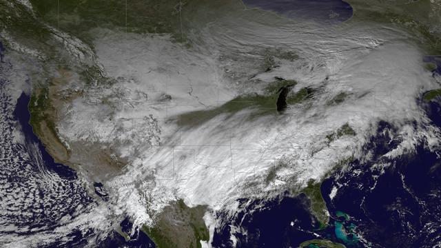
The powerful winter storm that has been affecting much of the central and western U.S. continues to intensify as it moves into Canada. Snow is tapering off across the Upper Midwest, but heavy snow is possible on Thursday from the Ohio Valle…

KENNEDY SPACE CENTER, FLA. - The storm surge and high winds of Hurricane Jeanne have replaced the rolling sand dunes on the KSC shoreline east of the launch pads with cliffs of sand, shown here. A category 3 storm, Jeanne barreled through…

CAPE CANAVERAL, Fla. – The United Launch Alliance Atlas V rocket with the Radiation Belt Storm Probes, or RBSP, spacecraft aboard stands at the launch pad at Space Launch Complex 41 at Cape Canaveral Air Force Station. NASA’s RBSP mission w…

KENNEDY SPACE CENTER, FLA. - Center Director James Kennedy (left) is aboard a helicopter to observe damage from Hurricane Jeanne. A category 3 storm, Jeanne barreled through Central Florida Sept. 25-26, the fourth hurricane in 6 weeks to…

KENNEDY SPACE CENTER, FLA. - At the Delta Operations Center, Leslie Guzman (yellow shirt), with Pratt and Whitney, watches closely as the nozzle for the RL-10 engine is lifted into place on the second stage of the Boeing Delta IV rocket.…

Oct. 29, 2012 – A day before landfall, Sandy intensified into a Category 2 superstorm nearly 1,000 miles wide. Credit: NASA's Goddard Space Flight Center and NASA Center for Climate Simulation Video and images courtesy of NASA/GSFC/Willia…

CAPE CANAVERAL, Fla. – The United Launch Alliance Atlas V rocket with the Radiation Belt Storm Probes, or RBSP, spacecraft aboard is readied for rollout to the launch pad at Space Launch Complex 41 at Cape Canaveral Air Force Station. NASA’…

CAPE CANAVERAL, Fla. – The United Launch Alliance Atlas V rocket with the Radiation Belt Storm Probes, or RBSP, spacecraft aboard is readied for rollout to the launch pad at Space Launch Complex 41 at Cape Canaveral Air Force Station. NASA’…
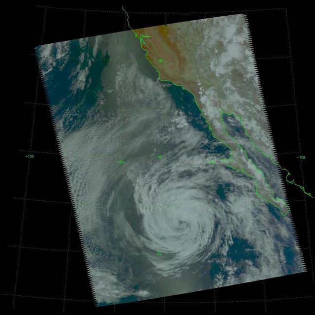
Tropical Storm Blas as observed by the Atmospheric Infrared Sounder AIRS onboard NASA Aqua in the year 2004. The major contribution to radiation (infrared light) that AIRS channels sense comes from different levels in the atmosphere, depend…
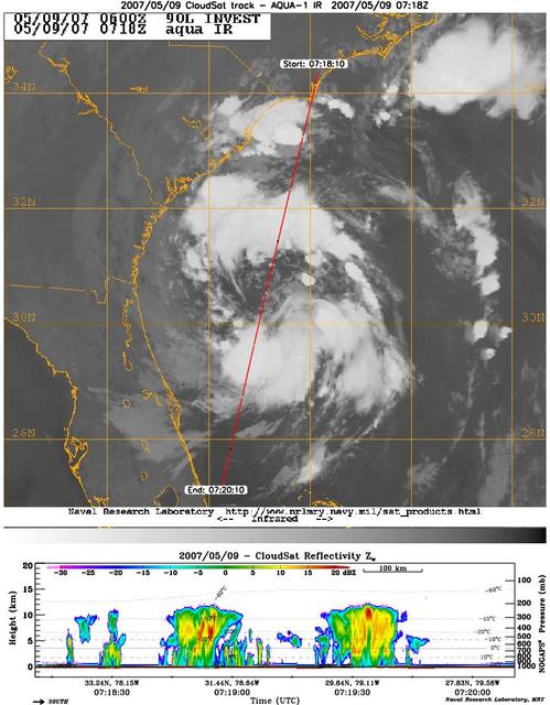
CloudSat's Cloud Profiling Radar captured a profile across Tropical Storm Andrea on Wednesday, May 9, 2007, near the South Carolina/Georgia/Florida Atlantic coast. The upper image shows an infrared view of Tropical Storm Andrea from the Mod…

It is easy to see the effect of the strong northeasterly wind shear battering Tropical Storm Gaemi in satellite imagery from NASA. This true-color image acquired on Oct. 5 shows a large oval-shaped area of showers and thunderstorms associat…

KENNEDY SPACE CENTER, FLA. - In this aerial view, damage is apparent on the roof of the Apollo/Saturn V Building at KSC from Hurricane Jeanne. A category 3 storm, Jeanne barreled through Central Florida Sept. 25-26, the fourth hurricane i…

Tropical Storm Toraji Approaching Japan, 09/03/2013 at 02:10 UTC. Terra/MODIS <b><a href="http://www.nasa.gov/audience/formedia/features/MP_Photo_Guidelines.html" rel="nofollow">NASA image use policy.</a></b> <b><a href="http://www.nasa.…

The monster winter storm that brought icing to the U.S. southeast moved northward along the Eastern Seaboard and brought snow, sleet and rain from the Mid-Atlantic to New England on February 13. A new image from NOAA's GOES satellite showed…

This image shows the strom system on Dec. 10, 2013 at 1445 UTC. According to the National Weather Service snow is falling from Tennessee Valley into the Mid-Atlantic and New England Tuesday . The fast moving system is creating swath of 2 t…

NASA image acquired August 28, 2012 Early on August 28, 2012, the Visible Infrared Imaging Radiometer Suite (VIIRS) on the Suomi-NPP satellite captured this nighttime view of Tropical Storm Isaac and the cities near the Gulf Coast of the U…

This full disc image of earth shows the strom system on Dec. 10, 2013 at 1445 UTC. According to the National Weather Service snow is falling from Tennessee Valley into the Mid-Atlantic and New England Tuesday . The fast moving system is…

CAPE CANAVERAL, Fla. – The United Launch Alliance Atlas V rocket with the Radiation Belt Storm Probes, or RBSP, spacecraft aboard rolls to the launch pad at Space Launch Complex 41 at Cape Canaveral Air Force Station. NASA’s RBSP mission wi…
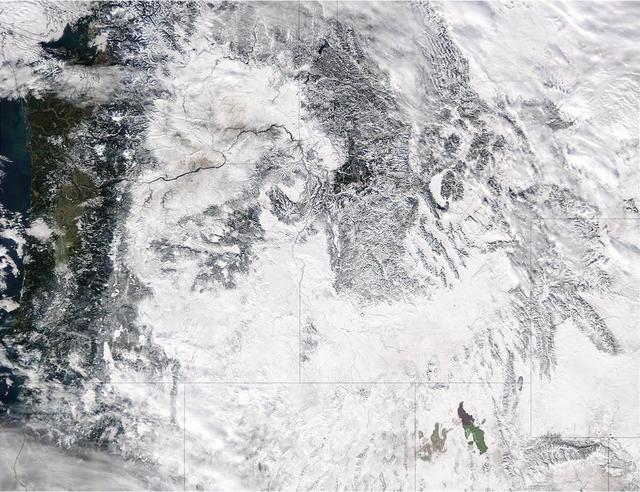
Extreme rain events have been affecting California and snow has blanketed the Pacific Northwest. This visible image from NASA's Aqua satellite on Jan. 6, 2017, at 3:35 p.m. EST (20:35 UTC) shows snow cover in the U.S. Pacific Northwest in W…

KENNEDY SPACE CENTER, FLA. - The storm surge and high winds of Hurricane Jeanne have replaced the rolling sand dunes on the KSC shoreline with cliffs of sand, shown here. A category 3 storm, Jeanne barreled through Central Florida Sept. 25…
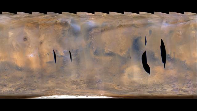
This frame from a movie clip of hundreds of images from NASA's Mars Reconnaissance Orbiter shows a global map of Mars with atmospheric changes from Feb. 18, 2017 through March 6, 2017, a period when two regional-scale dust storms appeared.…

CAPE CANAVERAL, Fla. – The United Launch Alliance Atlas V rocket with the Radiation Belt Storm Probes, or RBSP, spacecraft aboard stands at the launch pad at Space Launch Complex 41 at Cape Canaveral Air Force Station. NASA’s RBSP mission w…

CAPE CANAVERAL, Fla. – Workers help guide the United Launch Alliance Atlas V rocket with the Radiation Belt Storm Probes, or RBSP, spacecraft aboard as it moves to the launch pad at Space Launch Complex 41 at Cape Canaveral Air Force Statio…

CAPE CANAVERAL, Fla. – The United Launch Alliance Atlas V rocket with the Radiation Belt Storm Probes, or RBSP, spacecraft aboard stands at the launch pad at Space Launch Complex 41 at Cape Canaveral Air Force Station. NASA’s RBSP mission w…