NASA Soil Moisture Active Passive SMAP spacecraft is slowly lowered into place in the Spacecraft Assembly Facility at NASA Jet Propulsion Laboratory, Pasadena, California.
NASA Soil Moisture Active Passive SMAP Lowered into Place
Dara Entekhabi, SMAP science team lead, Massachusetts Institute of Technology, speaks during a briefing about the upcoming launch of the Soil Moisture Active Passive (SMAP) mission, Thursday, Jan. 08, 2015, at NASA Headquarters in Washingto…
Soil Moisture Active Passive (SMAP) Media Briefing
NASA Soil Moisture Active Passive SMAP satellite is transported across Vandenberg Air Force Base in California to Space Launch Complex 2, where it will be mated to a Delta II rocket for launch, targeted for Jan. 29.
Satellite in a Can
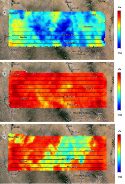
NASA's SMAP (Soil Moisture Active Passive) satellite observatory conducted a field experiment as part of its soil moisture data product validation program in southern Arizona on Aug. 2-18, 2015. The images here represent the distribution of…
NASA SMAPVEX 15 Field Campaign Measures Soil Moisture Over Arizona
At Space Launch Complex 2 on Vandenberg Air Force Base in California, NASA Soil Moisture Active Passive SMAP mission satellite is lifted up the side of a mobile service tower for mating to its Delta II rocket.
Going Up
This image, created at the Jet Propulsion Laboratory JPL, shows the Soil Moisture Active Passive SMAP mission, specifically depicting how the scanning antenna will fly in space and the swath coverage over the Earth.
SMAP Flys over Earth Artist Concept
NASA Soil Moisture Active Passive spacecraft is lowered onto the Delta II payload attach structure in the Astrotech payload processing facility at Vandenberg Air Force Base, California, in preparation for launch, to take place no sooner tha…
NASA SMAP is Readied for Launch
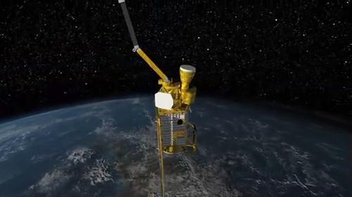
Artist rendering of the Soil Moisture Active Passive SMAP satellite. The width of the region scanned on Earth surface during each orbit is about 620 miles 1,000 kilometers.
Soil Moisture Active Passive Satellite
Images of soil moisture conditions in Texas near Houston, generated by NASA's Soil Moisture Active Passive (SMAP) satellite before and after the landfall of Hurricane Harvey can be used to monitor changing ground conditions due to Harvey's…
NASA SMAP Images Show Texas Soil Moisture Conditions Before/After Hurricane Harvey's Landfall
This pair of images shows ocean surface wind speeds for Hurricane Irma as observed at 5:26 a.m. EDT on Sept. 4, 2017 (top) and 24.5 hours later at 6:02 a.m. EDT on September 5th (bottom) by the radiometer instrument on NASA's Soil Moisture…
Rapid Intensification of Hurricane Irma Seen in New SMAP Wind Images
NASA Soil Moisture Active Passive SMAP mission will produce high-resolution global maps of soil moisture to track water availability around our planet and guide policy decisions.
NASA Soil Moisture Active Passive SMAP Artist Concept
Christine Bonniksen, SMAP program executive with the Science Mission Directorate’s Earth Science Division at NASA Headquarters speaks during a briefing about the upcoming launch of the Soil Moisture Active Passive (SMAP) mission, Thursday,…
Soil Moisture Active Passive (SMAP) Media Briefing
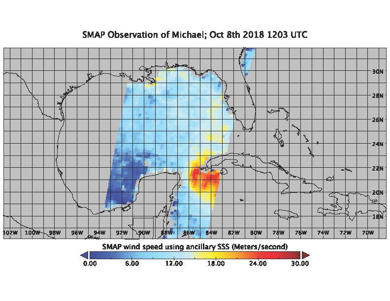
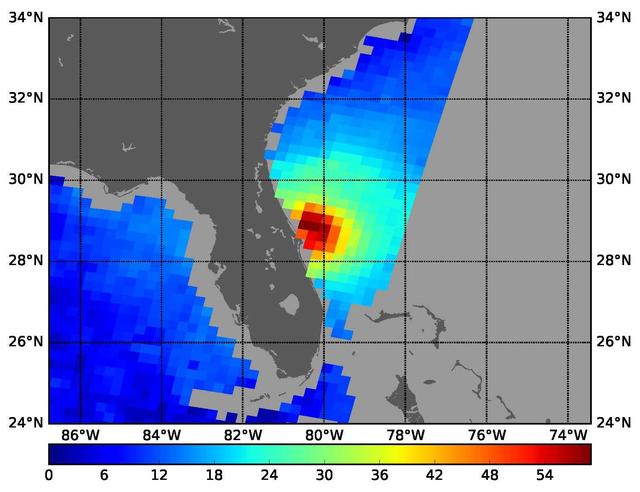
On the morning of Oct. 8, 2018, the NASA Soil Moisture Active Passive (SMAP) Radiometer got a snapshot of Hurricane Michael, which has intensified to a Category 2 hurricane over the warm waters of the Gulf of Mexico. The radiance acquired b…
SMAP captures Hurricane Michael
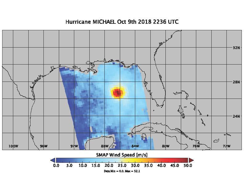
On Oct. 9, 2018 at about 4:30pm EDT, the NASA Soil Moisture Active Passive (SMAP) Radiometer got one more snap shot of Hurricane Michael. The radiance acquired by the SMAP L-band Microwave Radiometer can see through clouds and rain, and is…
Hurricane Michael as seen by SMAP
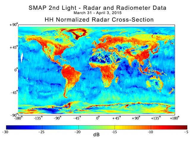
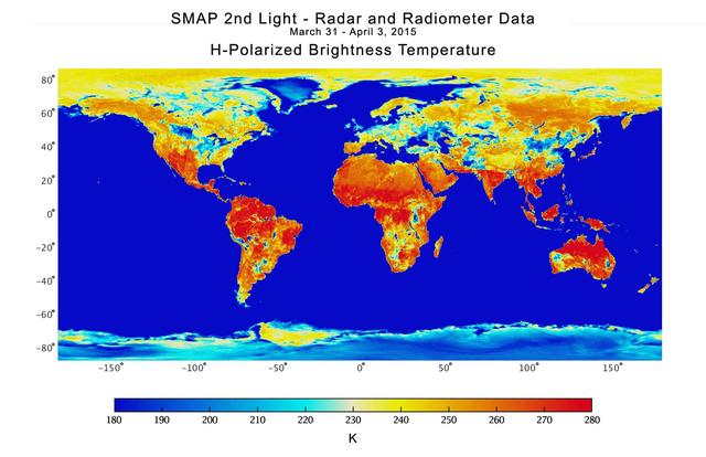
With its antenna now spinning at full speed, NASA new Soil Moisture Active Passive SMAP observatory has successfully re-tested its science instruments and generated its first global maps, a key step to beginning routine science operations i…
NASA Soil Moisture Mission Produces First Global Radar Map
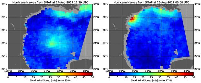
The rapid intensification of Hurricane Harvey is seen in this pair of images of ocean surface wind speeds as observed by the radiometer instrument aboard NASA's Soil Moisture Active Passive (SMAP) satellite at 7:29 a.m. CDT Aug. 24th, 2017…
Hurricane Harvey's Rapid Wind Intensification seen by NASA's SMAP
High-resolution global soil moisture map from NASA SMAP combined radar and radiometer instruments, acquired between May 4 and May 11, 2015 during SMAP commissioning phase. The map has a resolution of 5.6 miles (9 kilometers). The data gap i…
High-Resolution Global Soil Moisture Map
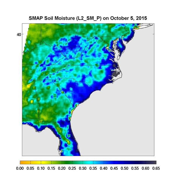
Surface soil moisture in the Southeastern United States as retrieved from NASA's Soil Moisture Active Passive (SMAP) satellite observatory at around 6 a.m. on Oct. 5, 2015. Large parts of South Carolina appear blue, representing the impact…
Devastating Carolina Floods Viewed by NASA SMAP
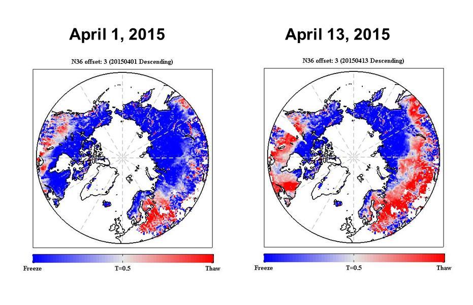
The radar measurements made by NASA Soil Moisture Active Passive SMAP observatory are sensitive to whether land surfaces are frozen or thawed.
NASA SMAP Images Show Progression of Spring Thaw in Northern Hemisphere
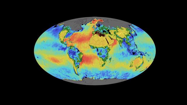
This animation shows a time lapse of sea surface salinity and soil moisture from NASA's Soil Moisture Active Passive (SMAP) satellite from April 2015 through February 2019.  Animation available at https://photojournal.jpl.nasa.gov/catalog/P…
SMAP Sea Surface Salinity and Soil Moisture Time Lapse
A three-day composite global map of surface soil moisture as retrieved from NASA SMAP radiometer instrument between Aug. 25-27, 2015. Dry areas appear yellow/orange, such as the Sahara Desert, western Australia and the western U.S. Wet area…
SMAP Global Map of Surface Soil Moisture Aug. 25-27, 2015
Data from NASA's Soil Moisture Active Passive (SMAP) satellite have been used to create new surface flooding maps of Southeast Texas and the Tennessee Valley following Hurricane Harvey. The SMAP observations detect the proportional cover of…
New NASA Maps Show Flooding Changes In Aftermath of Hurricane Harvey
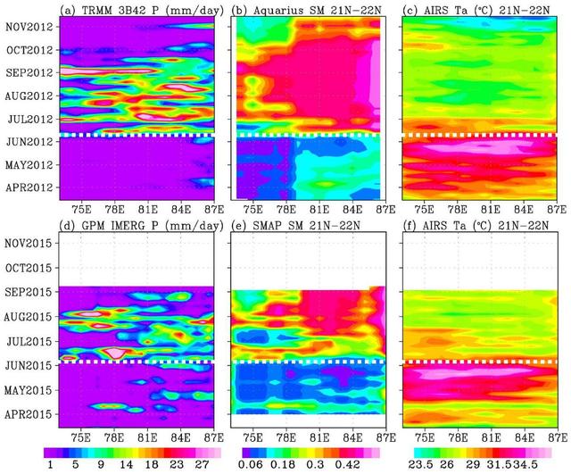
In June 2015, news organizations around the world reported on a deadly heat wave in India that killed more than 2,300 people. Prior to the arrival of the summer monsoon in India, weather conditions had been extremely hot and dry. Such condi…
Pre-Monsoon Drought and Heat Waves in India
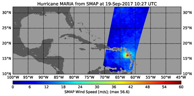
The radiometer instrument on NASA's Soil Moisture Active Passive (SMAP) spacecraft captured this image of Hurricane Maria at 6:27 a.m. EDT on Sept. 19, 2017 (10:27 UTC), showing an estimated maximum surface wind speed of 126.6 miles per hou…
Hurricane Maria's Strengthening Winds Seen in NASA SMAP Image
Christine Bonniksen, SMAP program executive with the Science Mission Directorate’s Earth Science Division, NASA Headquarters, left, Kent Kellogg, SMAP project manager, NASA Jet Propulsion Laboratory (JPL), second from left, Dara Entekhabi,…
Soil Moisture Active Passive (SMAP) Media Briefing
Brad Doorn, SMAP applications lead, Science Mission Directorate’s Applied Sciences Program at NASA Headquarters speaks during a briefing about the upcoming launch of the Soil Moisture Active Passive (SMAP) mission, Thursday, Jan. 08, 2015,…
Soil Moisture Active Passive (SMAP) Media Briefing
Kent Kellogg, SMAP project manager at NASA’s Jet Propulsion Laboratory (JPL) in Pasadena, CA, speaks during a briefing about the upcoming launch of the Soil Moisture Active Passive (SMAP) mission, Thursday, Jan. 08, 2015, at NASA Headquarte…
Soil Moisture Active Passive (SMAP) Media Briefing
Southern U.S. NASA's SMAP soil moisture retrievals from April 27, 2015, when severe storms were affecting Texas. Top: radiometer data alone. Bottom: combined radar and radiometer data with a resolution of 5.6 miles (9 kilometers). The combi…
Southern U.S. Soil Moisture Map
In the Astrotech payload processing facility on Vandenberg Air Force Base in California, technicians secure a transportation canister around NASA Soil Moisture Active Passive SMAP spacecraft for its move to the launch pad.
SMAP Gets Ready to Move
The sun sets behind Space Launch Complex 2, Vandenberg Air Force Base, California, where NASA Soil Moisture Active Passive SMAP mission satellite is being prepared for liftoff. Launch is scheduled for Jan. 29.
Sunset at Vandenberg
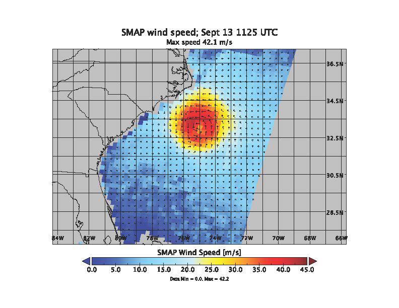
SMAP wind estimates over Hurricane Florence on Sept. 12, 2018 at 10:49 UTC and on Sept. 13, 2018 at 11:25 UTC. We see weakening of the hurricane from the 12th to the 13th; however, the overall size and energy of the storm has increased. The…
Hurricane Florence seen by SMAP Imagery
These maps of global soil moisture were created using data from the radiometer instrument on NASA Soil Moisture Active Passive SMAP observatory. Evident are regions of increased soil moisture and flooding during April, 2015.
SMAP Radiometer Captures Views of Global Soil Moisture
With its antenna now spinning at full speed, NASA new Soil Moisture Active Passive SMAP observatory has successfully re-tested its science instruments and generated its first global maps, a key step to beginning routine science operations i…
NASA Soil Moisture Mission Produces First Global Radiometer Map
Dara Entekhabi, SMAP science team lead, Massachusetts Institute of Technology, center, speaks during a briefing about the upcoming launch of the Soil Moisture Active Passive (SMAP) mission, Thursday, Jan. 08, 2015, at NASA Headquarters in W…
Soil Moisture Active Passive (SMAP) Media Briefing
Several Goddard technologists are involved in a new CubeSat technology-demonstration mission called SNoOPI, which employs a novel remote-sensing technique for measuring soil-moisture levels. From left to right: Jeffrey Piepmeier, Chase Kiel…
SNoOPI: A Flying Ace for Soil Moisture and Snow Measurements
NASA's SMAP radiometer instrument measured Hurricane Matthew's wind speeds at 4:52 a.m. PDT (7:52 a.m. EDT) at up to 132 miles per hour (59 meters per second). SMAP has excellent sensitivity to extreme winds, far beyond that of typical scat…
SMAP Takes a New Measure of Hurricane Matthew Winds
Christine Bonniksen, SMAP program executive with the Science Mission Directorate’s Earth Science Division, NASA Headquarters, left, Kent Kellogg, SMAP project manager, NASA Jet Propulsion Laboratory (JPL), second from left, Dara Entekhabi,…
Soil Moisture Active Passive (SMAP) Media Briefing
No more images