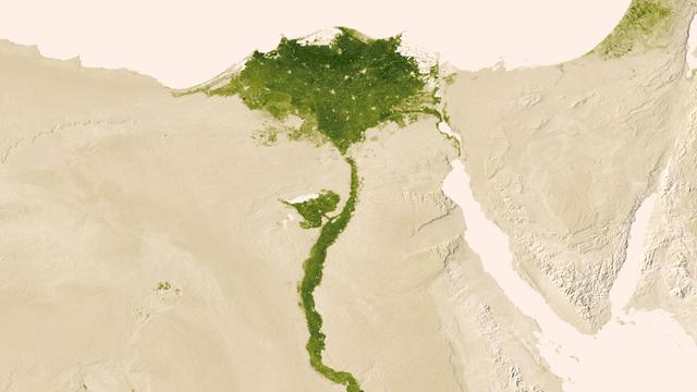
Urbanized areas of northern Egypt are visible amidst the deserts of Egypt. The image captured July 9-15, 2012 also shows the Nile River which provides life-sustaining water to the region. The image was created from the Visible-Infrared Imag…
Nile Delta
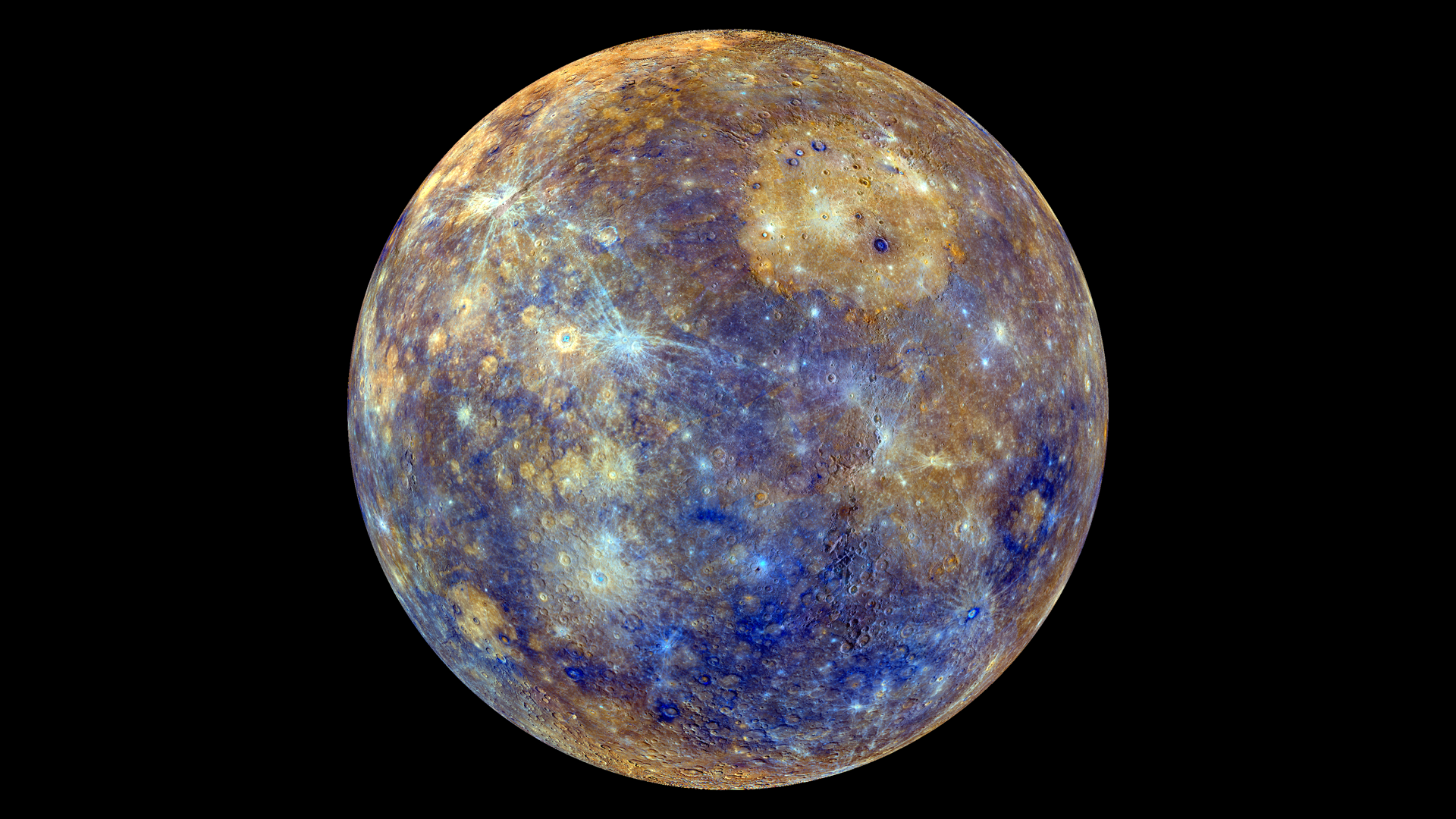
This colorful view of Mercury was produced by using images from the color base map imaging campaign during MESSENGER's primary mission. These colors are not what Mercury would look like to the human eye, but rather the colors enhance the ch…
False Color View of Mercury
Phytoplankton bloom in the Great Australian Bight captured by the MODIS instrument on the Aqua satellite on December 30, 2013 at 6:05 UTC.  The Great Australian Bight is a large bight, or open bay, off the central and western portions of th…
Phytoplankton Bloom off Coast of Australia
This NOAA GOES-East satellite animation shows the development of System 91L into Tropical Storm Andrea over the course of 3 days from June 4 to June 6, just after Andrea was officially designated a tropical storm.   Credit:  NASA's GOES Pro…
NASA Sees Heavy Rainfall in Tropical Storm Andrea
The GOES-East satellite captured a Midwestern wintertime "White Out" at 2015 UTC/3:15 p.m. EST on January 6, 2014. Blowing snow and intensely cold air created dangerous white-out conditions over the Midwest, particularly around th…
Satellite Sees a Midwest White Out
If the Moon were a perfectly smooth sphere of uniform density, the gravity map would be a single, featureless color, indicating that the force of gravity at a given elevation was the same everywhere. But like other rocky bodies in the solar…
Free-Air Gravity Map of the Moon
A major winter storm is poised to wallop the Mid-Atlantic and bring large amounts of snow to cities including Baltimore, Md., Washington, D.C. area on March 2 and 3, according to NOAA's National Weather Service. NOAA's GOES-East satellite c…
Satellite Sees Major Winter Storm Ready to Wallop Mid-Atlantic
The Moderate Resolution Imaging Spectroradiometer (MODIS) on NASA’s Terra satellite acquired this natural-color image of central China on January 23, 2013 at 04:05 UTC. The image shows extensive haze over the region.  In areas where the gro…
Haze in central China
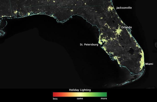
City lights shine brighter during the holidays in the United States when compared with the rest of the year, as shown using a new analysis of daily data from the NASA-NOAA Suomi NPP satellite. Dark green pixels are areas where lights are 50…
Satellite Sees Holiday Lights Brighten Cities - Florida
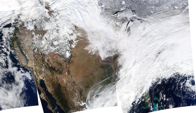
On January 2, 2014, NASA’s Aqua satellite passed over the United States mutiple times showing winter weather, allowing the Moderate Resolution Imaging Spectroradiometer (MODIS) on board to capture this true-color image of a massive winter s…
USA Composite Reveals Massive Winter Storm - January 02, 2014
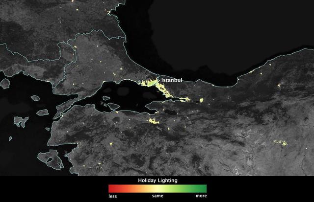
In several cities in the Middle East, city lights brighten during the Muslim holy month of Ramadan, as seen using a new analysis of daily data from the NASA-NOAA Suomi NPP satellite. Dark green pixels are areas where the lights are 50 perce…
Satellite Sees Holiday Lights Brighten Cities - Istanbul
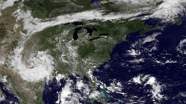
A very anomalous weather pattern is in place over the U.S. for mid-July. Trapped between an upper level ridge centered over the Ohio Valley and the closed upper level low over the Texas/Oklahoma border, atypical hot, muggy air is stifling a…
Heat Wave Building Into the Ohio Valley and Eastern United States
City lights shine brighter during the holidays in the United States when compared with the rest of the year, as shown using a new analysis of daily data from the NASA-NOAA Suomi NPP satellite. Dark green pixels are areas where lights are 50…
Satellite Sees Holiday Lights Brighten Cities - Los Angeles
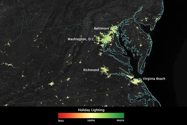
City lights shine brighter during the holidays in the United States when compared with the rest of the year, as shown using a new analysis of daily data from the NASA-NOAA Suomi NPP satellite. Dark green pixels are areas where lights are 50…
Satellite Sees Holiday Lights Brighten Cities - Washington, D.C., and Baltimore
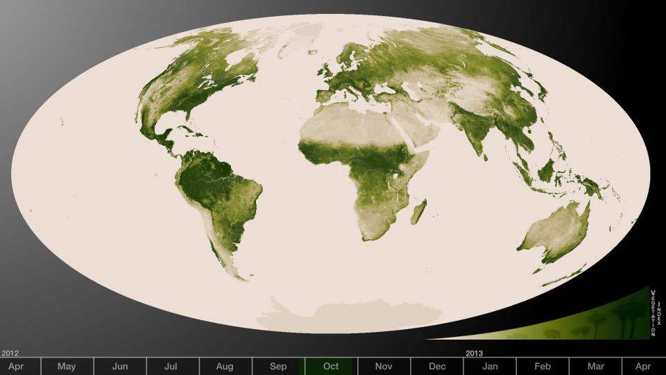
Subtle vegetation changes are visible in this year-long visualization.  Large-scale patterns vary with seasons, but the local variations in green are also sensitive precipitation, drought and fire. High values of Normalized Difference Veget…
Herbal Earth
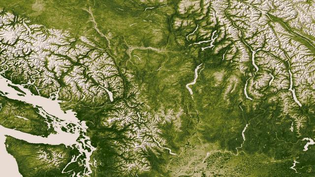
The Rocky, Cascade, and Coast Mountain Ranges dominate the landscape of the Pacific Northwest in this image created June 11-17, 2012 from the Visible-Infrared Imager/Radiometer Suite (VIIRS) instrument aboard the Suomi National Polar-orbiti…
Pacific Northwest
NASA's Aqua satellite observed swirls of sea ice along the coast of Greenland on December 30, 2012.  Credit: NASA/GSFC/Jeff Schmaltz/MODIS Land Rapid Response Team  <b><a href="http://www.nasa.gov/audience/formedia/features/MP_Photo_Guideli…
Southern Greenland
The skies over northern China were shrouded with a thick haze in late December, 2013. The Moderate Resolution Imaging Spectroradiometer (MODIS) aboard the Terra satellite captured this true-color image on December 23.  The dense, gray haze…
Haze over eastern China
On most days, relentless rivers of clouds wash over Alaska, obscuring most of the state’s 6,640 miles (10,690 kilometers) of coastline and 586,000 square miles (1,518,000 square kilometers) of land. The south coast of Alaska even has the du…
Rare Clear View of Alaska [high res]
Eight major wildfires burned through forests and grasslands in the Pacific Northwest in late-July 2013, threatening homes and forcing road closings and evacuations. Many parts of Washington and Oregon faced extreme fire threats, as strong t…
Mile Marker 28 Fire
An autumn storm brought the first snow of the season to the Upper Mississippi River Valley and the Midwestern United States in early November, 2013. The Moderate Resolution Imaging Spectroradiometer (MODIS) aboard NASA’s Terra satellite cap…
Autumn snow across the Midwest
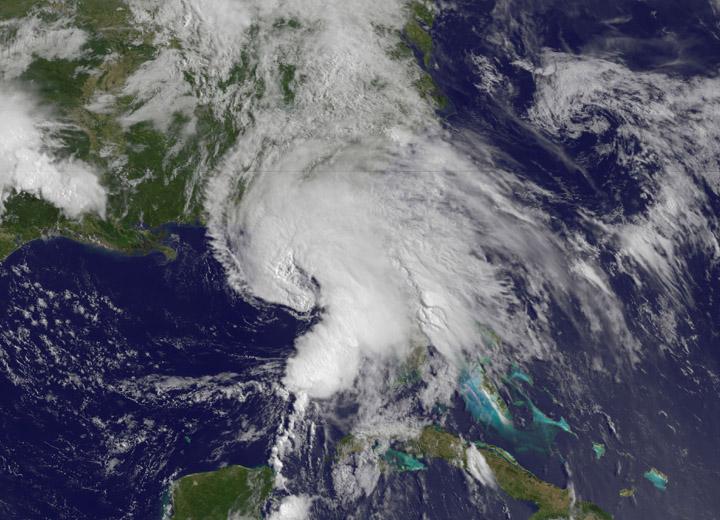
NASA’s Terra satellite passed over Tropical Storm Andrea on June 5 at 16:25 UTC (12:25 p.m. EDT) and the MODIS instrument captured this visible image of the storm. Andrea’s clouds had already extended over more than half of Florida.    Cred…
NASA Sees Heavy Rainfall in Tropical Storm Andrea
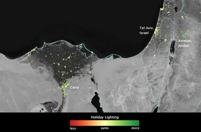
In several cities in the Middle East, city lights brighten during the Muslim holy month of Ramadan, as seen using a new analysis of daily data from the NASA-NOAA Suomi NPP satellite. Dark green pixels are areas where the lights are 50 perce…
Satellite Sees Holiday Lights Brighten Cities - Cairo
City lights shine brighter during the holidays in the United States when compared with the rest of the year, as shown using a new analysis of daily data from the NASA-NOAA Suomi NPP satellite. Dark green pixels are areas where lights are 50…
Satellite Sees Holiday Lights Brighten Cities - United States
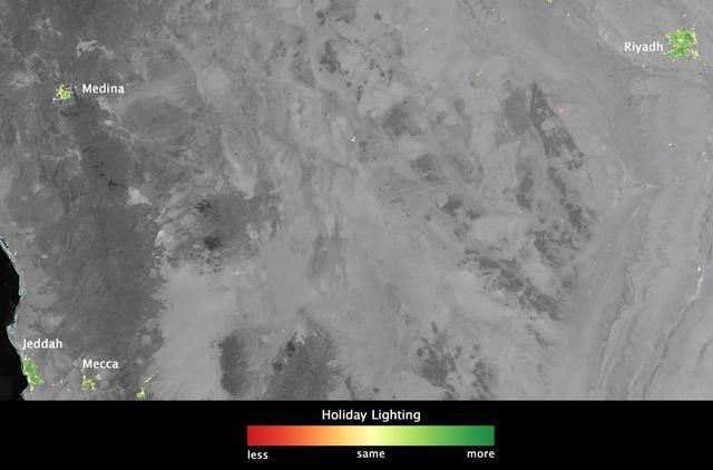
In several cities in the Middle East, city lights brighten during the Muslim holy month of Ramadan, as seen using a new analysis of daily data from the NASA-NOAA Suomi NPP satellite. Dark green pixels are areas where the lights are 50 perce…
Satellite Sees Holiday Lights Brighten Cities - Saudi Arabia
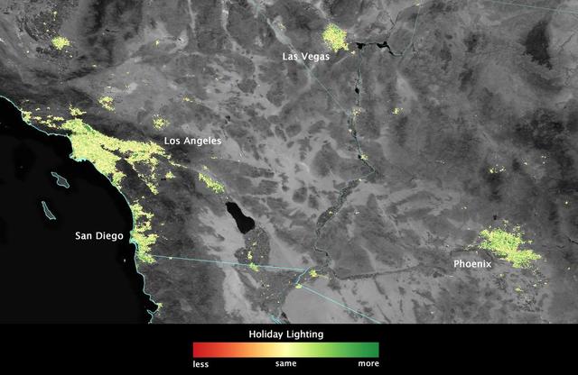
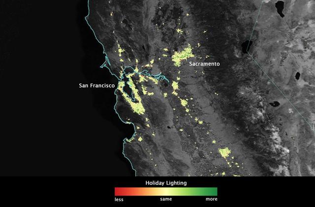
City lights shine brighter during the holidays in the United States when compared with the rest of the year, as shown using a new analysis of daily data from the NASA-NOAA Suomi NPP satellite. Dark green pixels are areas where lights are 50…
Satellite Sees Holiday Lights Brighten Cities - Southern California and the Southwest
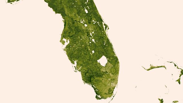
A &quot;river of grass&quot; extending south of Lake Okeechobee shows how the area was modified by man with visible areas of dense agriculture, urban sprawl and water conservation areas delineated by a series of waterways that crisscross So…
Florida Everglades
Located in the crater Eminescu, this high-resolution image shows part of the mountainous peak ring, as well as an example of the extensive formation of hollows located within the crater. Hollows maintain an air of mystery in the realm of pl…
Sublimation Formation on Mercury
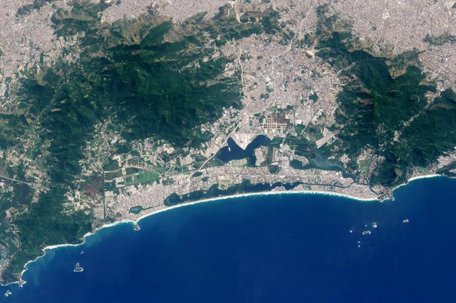
While gymnasts leap, cyclists pedal and divers twirl for Olympic gold in Rio de Janeiro, Brazil, several NASA Earth Observing satellites catch glimpses of the city and its surroundings from space.  This image shows how Rio Olympic Park appe…
Barra da Tijuca, Rio de Janeiro, from Space
<b>View a video of the storm here: <a href="http://bit.ly/1m9aJFY" rel="nofollow">bit.ly/1m9aJFY</a></b>  This visible image of the winter storm over the U.S. south and East Coast was taken by NOAA's GOES-13 satellite on Feb. 12 at 1855 UTC…
Satellite Video Shows Movement of Major U.S. Winter Storm
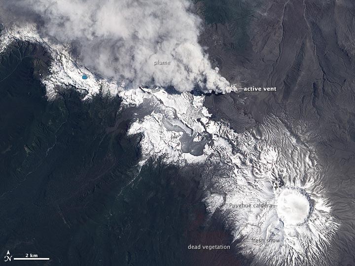
NASA image acquired December 23, 2011  In early June 2011, Chile’s Puyehue-Cordón Caulle Volcano erupted explosively, sending volcanic ash around the Southern Hemisphere. In late December 2011, activity at the volcano had calmed, but volcan…
Puyehue-Cordón Caulle [annotated]
NASA acquired November 24, 2011  From its vantage 824 kilometers (512 miles) above Earth, the Visible Infrared Imager Radiometer Suite (VIIRS) on the NPOESS Preparatory Project (NPP) satellite gets a complete view of our planet every day. T…
First Global Image from VIIRS
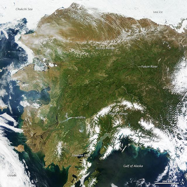
On most days, relentless rivers of clouds wash over Alaska, obscuring most of the state’s 6,640 miles (10,690 kilometers) of coastline and 586,000 square miles (1,518,000 square kilometers) of land. The south coast of Alaska even has the du…
Rare Clear View of Alaska [annotated]
NASA image acquired December 23, 2011  In early June 2011, Chile’s Puyehue-Cordón Caulle Volcano erupted explosively, sending volcanic ash around the Southern Hemisphere. In late December 2011, activity at the volcano had calmed, but volcan…
Puyehue-Cordón Caulle [high res]
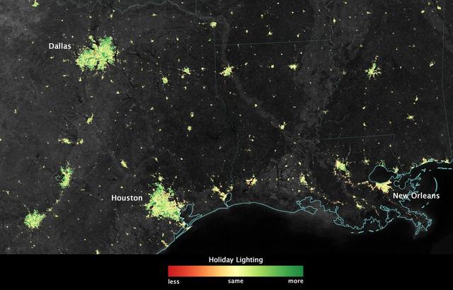
City lights shine brighter during the holidays in the United States when compared with the rest of the year, as shown using a new analysis of daily data from the NASA-NOAA Suomi NPP satellite. Dark green pixels are areas where lights are 50…
Satellite Sees Holiday Lights Brighten Cities - Texas and Louisiana
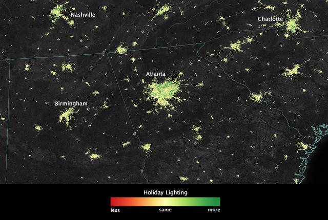
City lights shine brighter during the holidays in the United States when compared with the rest of the year, as shown using a new analysis of daily data from the NASA-NOAA Suomi NPP satellite. Dark green pixels are areas where lights are 50…
Satellite Sees Holiday Lights Brighten Cities - Atlanta
When NASA's Terra satellite flew over the Puyehue-Cordon Caulle volcano on July 8, 2011  at 14:25 UTC (10:25 a.m. EDT) it captured this visible image of a steady stream of ash (light brown) blowing southeast into Argentina. The Puyehue-Cord…
NASA's Terra Satellite Sees a Strong, Steady Stream of Ash from Puyehue Volcano
Clouds associated with the major winter storm that is bringing wintry precipitation and chilly temperatures to the U.S. south is the focus in an image from NOAA's GOES-East satellite today, February 12 at 1310 UTC/ 8:10 EST.  Rain, freezing…
Satellite Shows Major Winter Storm Hitting the U.S. South
Soggy winters are not unusual in the United Kingdom, but this winter has been in a category of its own. UK Met Office meteorologists had just declared January 2014 the wettest month on record for parts of southern Britain when another serie…
Extratropical Cyclone over the United Kingdom
No more images