
On April 29, 2015 the Moderate Resolution Imaging Spectroradiometer (MODIS) aboard NASA’s Terra satellite captured a true-color image of a typical spring scene in the western United State: snow-crowned Rocky Mountains rising above the faint…

In this southeast looking view, Mont Blanc, on the French/Italian border, (48.0N, 4.5E) the highest mountain peak in all of Europe, is just below and right of center (below the end of the prominent valley of the Aosta River, in the center o…

LITTLE BIG MOUNTAIN PERFORMS A TRADITIONAL NATIVE AMERICAN HOOP DANCE AT NASA MARSHALL SPACE FLIGHT CENTER’S 2015 NATIVE AMERICAN HERITAGE EVENT. THE EVENT, HELD NOV. 3 ON THE LAWN OF THE ACTIVITIES BUILDING, BUILDING 4316, HONORED THE CONT…

View of the northern Antarctic Peninsula from high altitude during IceBridge's flight back from the Foundation Ice Stream, on Oct. 28. Credit: NASA/Goddard/Maria-Jose Vinas NASA's Operation IceBridge is an airborne science mission to stu…

Dr. Kate Calvin, NASA's chief scientist and senior climate advisor, speaks at the 37th Space Symposium, Tuesday, April 5, 2022, in Colorado Springs, Colorado. Photo Credit: (NASA/Bill Ingalls)

Composite image of Background Oriented Schlieren (BOS) data (contour) with a cut-out images of the T-38’s during a Mach Number 1.01 pass. This data is the first time shockwave interactions between two full scale aircraft traveling faster th…

Mountains seen from the IceBridge DC-8 during a survey of the Getz Ice Shelf on Oct. 27, 2012. Credit: NASA / Christy Hansen NASA's Operation IceBridge is an airborne science mission to study Earth's polar ice. For more information about…
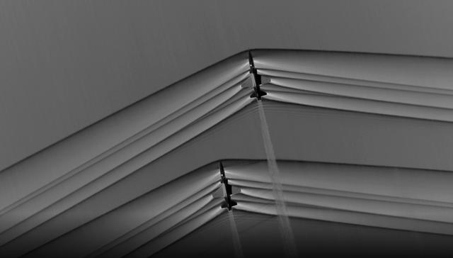
Composite image of Background Oriented Schlieren (BOS) data (contour) with a cut-out images of the T-38’s during a Mach Number 1.02 pass. The interaction of the shockwave of the trailing aircraft with the exhaust plume of the lead aircraft…
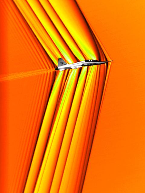
Composite image of Background Oriented Schlieren (BOS) data (contour) with a cut-out images of the T-38’s during a Mach Number 1.01 pass. This data is the first time shockwave interactions between two full scale aircraft traveling faster th…

In this photograph, Apollo 11 astronauts Edwin (Buzz) Aldrin (left) and Neil A. Armstrong prepare for the first Lunar landing as they practice gathering rock specimens during a geological field trip to the Quitman Mountains area near the Fo…

The northwest-southeast trending, snow-covered, linear mountain range is the King Ata Tag Mountain, located in extreme western most China. Highest peaks are just over 20,100 feet above sea level. The town or village of Muji is located in th…

As seen from space, the Great Salt Lake, Utah, USA (41.5N, 112.5W) appears as two separate bodies of water with a narrow divider in the middle. At the turn of the century, a railroad bridge without culverts, was built across the lake and ev…

STS035-501-007 (2-10 Dec. 1990) --- The STS-35 crewmembers aboard the Earth-orbiting Space Shuttle Columbia photographed this view of the Arid Simpson Desert of Australia with a handheld Rolleiflex camera. Lake Eyre is normally dry; however…

SL2-05-381 (22 June 1973) --- Boston, MA and the New England Coastline (43.5N, 84.0W) can be seen in this view. The typical rugged rocky coast of Maine is the result of heavy glacial action producing the rocky cliffs, jagged spurs of land a…

Pipistrel-USA Team Lead Jack Langelaan talks after his team won the 2011 Green Flight Challenge, sponsored by Google, on Monday, Oct. 3, 2011 at the NASA Ames Research Center, Mountain View, Calif. The all electric Taurus G4 aircraft achie…

STS058-085-091 (18 Oct-1 Nov 1993) --- Yellowstone Lake and the surrounding Plateau are centered in this scene of northwestern Wyoming, and adjacent Idaho and Montana. The view extends across the Absaroka Range to Billings, on the Yellowsto…

Alaskan mountains seen from high altitude aboard the NASA P-3B during the IceBridge transit flight from Thule to Fairbanks on Mar. 21, 2013. NASA's Operation IceBridge is an airborne science mission to study Earth's polar ice. For more in…

STS054-151-150 (13-19 Jan 1993) --- View west into sun glint off the Rio Salado, Saladillo, and Parana Rivers in Argentina. The Space Shuttle nadir is about 28 degrees north latitude and 57 degrees west longitude. The Andes Mountains are…

The Adriatic coast of Bosnia-Herzegovina and Croatia is centered at approximately 44.5 degrees north and 15.0 degrees east. North is at the bottom of the frame. The town of Bihac is located under the cloud layer in the center left of the fr…

NASA image acquired December 19, 2012 In time for the 2012 winter solstice, a storm dropped snow over most of the Rocky Mountains in the United States. On December 20, the National Weather Service reported snow depths exceeding 100 centime…

Mountains seen from the IceBridge DC-8 during a survey of the Getz Ice Shelf on Oct. 27, 2012. Credit: NASA / Christy Hansen NASA's Operation IceBridge is an airborne science mission to study Earth's polar ice. For more information about…

This high oblique view shows the majority of the island of Madagascar (19.0S, 47.5E). This Texas sized island is now largely deforested and is suffering from severe soil erosion as well as a declining biological species diversity and produc…

NASA image release April 22, 2010 This craggy fantasy mountaintop enshrouded by wispy clouds looks like a bizarre landscape from Tolkien's "The Lord of the Rings" or a Dr. Seuss book, depending on your imagination. The NASA Hubbl…

In this photograph, Apollo 11 astronaut Neil A. Armstrong uses a geologist’s hammer in selecting rock specimens during a geological field trip to the Quitman Mountains area near the Fort Quitman ruins in far west Texas. Armstrong, alongsid…

Pensacola Mountains near the Foundation Ice Stream, which Operation IceBridge surveyed on Oct. 28. Credit: NASA / Maria-Jose Vinas NASA's Operation IceBridge is an airborne science mission to study Earth's polar ice. For more information…

This view shows the west coast of the United States and Mexico (32.5N, 118.0W) and gives an indication of the range of view from orbital altitude. The visual range of this particular scene is from Skammon's Lagoon on Baja to the northern ti…

STS043-151-159 (2-11 August 1991) --- This photograph looks westward over the high plateau of the southern Peruvian Andes west and north of Lake Titicaca (not in field of view). Lima, Peru lies under the clouds just north of the clear coast…

SL2-04-018 (June 1973) --- A vertical view of the Arizona-Utah border area showing the Colorado River and Grand Canyon photographed from the Skylab 1/2 space station in Earth orbit. This picture was taken by one of the six lenses of the Ite…

AST-02-130 (20 July 1975) --- An oblique view of a portion of Libya and the Arab Republic of Egypt, as photographed from the Apollo spacecraft in Earth orbit during the joint U.S.-USSR Apollo-Soyuz Test Project mission. The geological featu…

STS040-151-123 (5-14 June 1991) --- This large format view shows parts of northern Arizona and southern Utah. San Juan River, Lake Powell and Monument Valley are visible. Water of Lake Powell can be seen filling the valleys of the Colorad…

Colorado’s Rocky Mountain National Park presents a very different landscape in summertime than in wintertime. Snow retreats and gives way to blooms of wildflowers, even at high elevations. Roads and trails become accessible, allowing visito…

This photograph captures the exotic volcanic terrain of the Altiplano of the Central Andes. Some of the remarkable details include the west-pointing wind streaks, resulting from fine dust being transported across the Andes by high winds; pa…

In this oblique view of the Georgia and South Carolina coast, the southern most Appalachians (32.0N, 83.0W) dominate the foreground. Contrails criss cross over Atlanta, a major airline hub. The coastal plain which wraps around the southern…

Evidence of a recent flash flood can be seen in the form of light brown sediment that flowed down gullies and mountain sides forming ponds of debris over agricultural areas in the broad valley near the town of Parras (26.5N, 102.5W). This p…

Dr. Kate Calvin, NASA's chief scientist and senior climate advisor, speaks at the 37th Space Symposium, Tuesday, April 5, 2022, in Colorado Springs, Colorado. Photo Credit: (NASA/Bill Ingalls)

Activities at Green Mountain Tracking Station, Alabama, during lift-off of the Saturn I, SA-9 mission, showing the overall view of instrument panels used in tracking the Pegasus, meteoroid-detection satellite. The satellite was used to obta…

Composite image of Background Oriented Schlieren (BOS) data (contour) with a cut-out images of the T-38’s during a Mach Number 1.02 pass. The interaction of the shockwave of the trailing aircraft with the exhaust plume of the lead aircraft…

Dr. Kate Calvin, NASA's chief scientist and senior climate advisor, speaks at the 37th Space Symposium, Tuesday, April 5, 2022, in Colorado Springs, Colorado. Photo Credit: (NASA/Bill Ingalls)

STS059-228-094 (9-20 April 1994) --- The spring thaw along the coast of the Gulf of Alaska has not touched the St. Elias Mountains, southeast of Yakutat Bay and Malaspina Glacier. A prominent glacier flows from Mt. Fairweather (15,300 feet…

S66-38290 (5 June 1966) --- The north coastal area of Peru looking southeast across the Andes Mountains as seen from the National Aeronautics and Space Administration's Gemini-9A spacecraft. The body of water is the Pacific Ocean. The image…

Composite image of Background Oriented Schlieren (BOS) data (contour) with a cut-out images of the T-38’s during a Mach Number 1.01 pass. This data is the first time shockwave interactions between two full scale aircraft traveling faster th…

STS-65 Earth observation taken aboard Columbia, Orbiter Vehicle (OV) 102, shows Northern Chile and the Andes Mountains. This color photograph is a panoramic (southern view) that features Chile and the Andes Mountains of South America. The A…
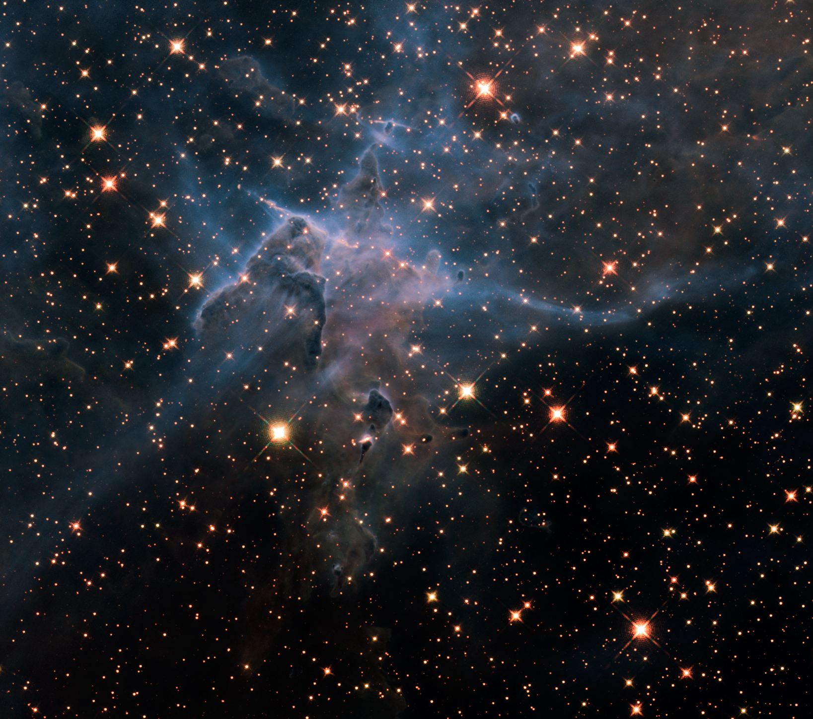
NASA image release April 22, 2010 This is a NASA Hubble Space Telescope near-infrared-light image of a three-light-year-tall pillar of gas and dust that is being eaten away by the brilliant light from nearby stars in the tempestuous stella…

STS031-79-015 (24-29 April 1990) --- The 330-plus nautical mile orbital altitude of the Space Shuttle Discovery allowed for this unique high oblique 70mm Hasselblad frame. Egypt is in the foreground, with the Nile River and Lake Nasser re…

STS047-151-488 (12 - 20 Sept 1992) --- In this large format camera image, the forested Cascade Range appears along the left side; the Pacific Ocean, on the right. The frame was photographed as the Space Shuttle Endeavour flew north to sout…

STS059-225-072 (9-20 April 1994) --- Orient with the tuning fork away from the viewer (sunglint is always south of the spacecraft at this latitude). Then the South Fork (left) and North Fork (right) of the Shenandoah meet in the foreground…

Comparative Aircraft Flight Efficiency (CAFE) Foundation President Brien A. Seeley M.D., left, NASA Acting Chief Technologist Joe Parrish, 2nd from left, and Pipistrel-USA Team Lead Jack Langelaan, center with suit, and the entire Pipistrel…