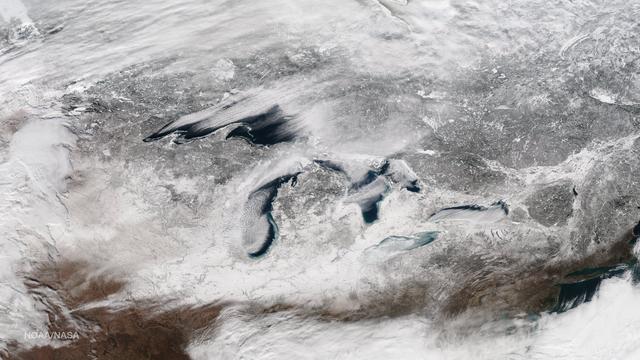
Bands of lake effect snow drift eastward from the western Great Lakes in this true-color image captured by the NOAA/NASA Suomi NPP satellite's Visible Infrared Imaging Radiometer Suite (VIIRS) instrument on January 5, 2017. National Weather…
Great Lakes
This image taken on January 13, 2015 from the Suomi NPP satellite's VIIRS instrument shows the Great Lakes and surrounding areas. The latest Great Lakes Surface Environmental Analysis (GLSEA) from the NOAA Great Lakes Environmental Research…
Great Lakes in January
S65-63830 (5 Dec. 1965) --- Algeria, south-southeast of the Colomb Bechar area, as seen from the National Aeronautics and Space Administration's Gemini-7 spacecraft. Sand dunes are 200 to 300 feet high in the Grand Erg Occidental area. The…
Algeria- Gemini 7, Earth-Sky View
STS035-501-007 (2-10 Dec. 1990) --- The STS-35 crewmembers aboard the Earth-orbiting Space Shuttle Columbia photographed this view of the Arid Simpson Desert of Australia with a handheld Rolleiflex camera. Lake Eyre is normally dry; however…
Lake Eyre, Simpson Desert, South Australia, Australia
In this late winter scene of Chicago, Illinois, USA (41.5N, 87.0W) the light dusting of snow has actually enhanced the determination of the cities street pattern, parks and other cultural features. Sited at the south end of Lake Michigan, C…
Chicago, Illinois, USA
NASA image acquired December 17, 2010  In mid-December 2010, suspended sediments transformed the southern end of Lake Michigan. Ranging in color from brown to green, the sediment filled the surface waters along the southern coastline and fo…
Sediment Transforms Lake Michigan
Though North America is a full month into astronomical spring, the Great Lakes have been slow to give up on winter. As of April 22, 2014, the Great Lakes were 33.9 percent ice covered. The lake they call Superior dominated the pack. In the…
Persistent Ice on Lake Superior
The DC-8 aircraft is seen making a banking turn high above the NASA Dryden ramp. This view of the DC-8's left side reveals some of the modifications necessary for particular on-board experiments. To the right of the DC-8 is the edge of Roge…
DC-8 Airborne Laboratory in flight over NASA Dryden center with SCA 747 on ramp
Aircraft mechanics reposition the Twin Otter after a research flight. The aircraft was used to gather data from Lake Erie for the Algae Bloom Project.
Twin Otter Aircraft
Event attendees view the eclipse on April 8, 2024. NASA Glenn Research Center and the Great Lakes Science Center hosted a three-day celestial celebration in downtown Cleveland, OH. This free, outdoor, family-friendly science and arts festiv…
Total Solar Eclipse
STS031-79-015 (24-29 April 1990)  --- The 330-plus nautical mile orbital altitude of the Space Shuttle Discovery allowed for this unique high oblique 70mm Hasselblad frame.  Egypt is in the foreground, with the Nile River and Lake Nasser re…
Eastern Egypt, Red Sea and Saudi Arabia
The Moon is seen passing in front of the Sun during a solar eclipse from Ross Lake, Northern Cascades National Park, Washington on Monday, Aug. 21, 2017. A total solar eclipse swept across a narrow portion of the contiguous United States fr…
2017 Total Solar Eclipse
SL2-05-380 (22 June 1973) --- Ottawa, in the province of Ontario, (46.5N, 75.5W) is the capital of Canada and can be seen near the bottom of this scene on the Ottawa River. The region shown lies within the Canadian Shield. The glaciated sur…
Ottawa, Quebec Province, Canada and Glaciated Landscape
This rear-quarter view shows off the unique lines of Boeing's X-48B Blended Wing Body technology demonstrator on Rogers Dry Lake adjacent to NASA Dryden.
This rear-quarter view shows off the unique lines of Boeing's X-48B Blended Wing Body technology demonstrator on Rogers Dry Lake adjacent to NASA Dryden
Founder and CEO of Future Engineers, Deanne Bell, speaks to the audience at an event to announce the official name of the Mars 2020 rover, Thursday, March 5, 2020, at Lake Braddock Secondary School in Burke, Va. The final selection of the n…
Mars 2020 Rover Name Announcement
Fairfax County Division Superintendent Scott Brabrand speaks about the importance of STEM at an event to announce the official name of the Mars 2020 rover, Thursday, March 5, 2020, at Lake Braddock Secondary School in Burke, Va. The final s…
Mars 2020 Rover Name Announcement
This is a single scene from a pair (frames 021 & 024) to study the effects of polarized light in Earth Observations. One scene was exposed with vertically polarized light, the other, horizontally. The subject in this study, is a lake behind…
Polarized Light Experiment, Presa Don Martin, Mexico
As seen from space, the Great Salt Lake, Utah, USA (41.5N, 112.5W) appears as two separate bodies of water with a narrow divider in the middle. At the turn of the century, a railroad bridge without culverts, was built across the lake and ev…
Great Salt Lake, Utah, USA
In orbit above the semi-desert grasslands in Kazakhstan, an astronaut aboard the International Space Station spotted one of the few features that stand out. Lake Tengiz is the only large lake (1590 square kilometers, 615 square miles) in no…
Lake Tengiz from space
This is a view of the Great Salt Lake and nearby Bonneville Salt Flats, UT, (41.0N, 112.5W). A railroad causeway divides the lake with a stark straight line changing the water level and chemistry of the lake as a result. Fresh water runoff…
Great Salt Lake and Bonneville Salt Flats, UT, USA
Africa's Lake Chad where the borders of Chad, Niger, Nigeria and Cameroon merge (13.0N, 14.0E) has been undergoing change for the past 25 to 30 years when it was first noticed that the lake is drying up. Since then, astronauts have been pho…
Lake Chad, Chad, Africa
S77-28137 (13 Sept 1977) --- The Orbiter 101 "Enterprise" soars above the NASA 747 carrier aircraft during the second free flight of the Shuttle Approach and Landing Tests (ALTs) conducted on September 13, 1977 at Dryden Flight Research Cen…
Approach & Landing Test (ALT) - Shuttle Free-Flight (FF)-2 - New Release - DFRC, CA
S77-28136 (13 Sept 1977) --- The Orbiter 101 "Enterprise" is seen separating from the NASA 747 carrier aircraft during the second free flight of the Shuttle Approach and Landing Tests (ALTs) conducted on September 13, 1977 at Dryden Flight…
Approach & Landing Test (ALT) - Shuttle Free-Flight (FF)-2 - New Release - Dryden Flight Research Center (DFRC), CA
SL2-05-422 (22 June 1973) --- This section of the lower Mississippi River (34.0N, 90.0W) known as the Yazoo Basin, is characterized by a wide expanse of rich river bottomland with many oxbow lakes, the remains of the many changes in the riv…
Mississippi River, Yazoo Basin, Memphis, TN
A Beech T-34C aircraft used by NASA Dryden Flight Research Center for mission support banks over Lake Isabella in Kern County during a recent flight.
A Beech T-34C aircraft used by NASA Dryden Flight Research Center for mission support banks over Lake Isabella in Kern County during a recent flight
A Beech T-34C aircraft used by NASA Dryden Flight Research Center for mission support banks over Lake Isabella in Kern County during a recent flight.
A Beech T-34C aircraft used by NASA Dryden Flight Research Center for mission support banks over Lake Isabella in Kern County during a recent flight
SL2-05-390 (22 June 1973) --- Greater Detroit (42.0N, 82.5W) is located at the southeastern border of Michigan on the Detroit River across from Windsor, Ontario, Canada and Lake Huron to the north. The river connecting Lake Erie is a channe…
Detroit, MI, Toledo, OH and Lake Erie
SL2-04-018 (June 1973) --- A vertical view of the Arizona-Utah border area showing the Colorado River and Grand Canyon photographed from the Skylab 1/2 space station in Earth orbit. This picture was taken by one of the six lenses of the Ite…
Lake Powell, Colorado River, Utah and Grand Canyon, Arizona
SL2-05-381 (22 June 1973) --- Boston, MA and the New England Coastline (43.5N, 84.0W) can be seen in this view. The typical rugged rocky coast of Maine is the result of heavy glacial action producing the rocky cliffs, jagged spurs of land a…
Boston, MA and New England Coastline
Event attendees view the eclipse. NASA Glenn Research Center and the Great Lakes Science Center hosted a three-day celestial celebration in downtown Cleveland, OH. This free, outdoor, family-friendly science and arts festival will feature f…
GRC-2024-C-03604
Boeing's X-48B Blended Wing Body technology demonstrator shows off its unique lines at sunset on Rogers Dry Lake adjacent to NASA's Dryden Flight Research Center. (Boeing photo # SMF06_F_KOEH_X48B-0900a)
Boeing's X-48B Blended Wing Body technology demonstrator shows off its unique lines at sunset on Rogers Dry Lake adjacent to NASA DFRC
STS040-151-123 (5-14 June 1991) --- This large format view shows parts of northern Arizona and southern Utah.  San Juan River, Lake Powell and Monument Valley are visible.  Water of Lake Powell can be seen filling the valleys of the Colorad…
Lake Powell, SE Utah and NE Arizona, USA
AST-30-2601 (20 July 1975) --- An area of the Cascade Mountains southeast of Seattle in the State of Washington, as photographed from the Apollo spacecraft in Earth orbit during the joint U.S.-USSR Apollo-Soyuz Test Project mission. The vie…
Area of Cascade Mountains southeast of Seattle in State of Washington
This view of the central portion of upstate New York, centers on the Finger Lakes. The large city on the shore of Lake Ontario, is Rochester. Although the city, being a business, educational and technical center, has no heavy industry, the…
Finger Lake Region, NY State, USA
Lake Mackay is the largest of hundreds of ephemeral lakes scattered throughout Western Australia and the Northern Territory, and is the second largest lake in Australia. The darker areas indicate some form of desert vegetation or algae, moi…
Lake Mackay, Australia
After 14 years of drought, Lake Powell was at 42 percent of its capacity as of May 20, 2014. The low water levels are evident in these images, which were acquired by the Landsat 8 satellite on May 13, 2014. White bleached rock show where La…
Lake Powell Half Empty
STS040-77-045 (6 June 1991) --- This image, photographed on June 6, 1991, is an oblique view looking north-northeast and shows most of the Great Lakes region.  Part of Columbia's cargo bay and the Spacelab Life Sciences (SLS-1) module are i…
Great Lakes Region, State of Michigan, USA
The planet Mercury is seen in silhouette as it transits across the face of the sun, Monday, Nov. 11, 2019 in Salt Lake City, Utah. Mercury’s last transit was in 2016.  the next won't happen again until 2032. Photo Credit: (NASA/Joel Kowsky)
Mercury Solar Transit
NASA image captured March 28, 2011  The Great Lakes  Satellite: Terra  <b><a href="http://www.nasa.gov/centers/goddard/home/index.html" rel="nofollow">NASA Goddard Space Flight Center</a></b> enables NASA’s mission through four scientific e…
The Great Lakes
NASA Glenn Research Pilot Jim Demers flies the T-34C Mentor aircraft. When NASA scientists study Great Lakes algal blooms, Demers is one of the pilots at the controls.
T-34C Mentor aircraft
NASA aircraft DC-9 microgravity plane performs it's first test parabolas over Lake Erie.  This was photographed by the NASA Glenn Lear Jet in a chase plane configuration.
GRC-1994-C-04159
Alexis Harry, assistant director of Astro Camp at NASA's John C. Stennis Space Center, talks with students at Lake Cormorant (Miss.) Elementary School during a 'Living and Working in Space' presentation March 30. Stennis hosted the school p…
Stennis visits Lake Cormorant school
This closeup of Boeing Phantom Works' unique X-48B Blended Wing Body technology demonstrator shows off its unusual engine placement and supercritical airfoil.
This closeup of Boeing Phantom Works' unique X-48B Blended Wing Body technology demonstrator shows off its unusual engine placement and supercritical airfoil
SL3-28-059 (July-September 1973) --- A vertical view of the Lake Mead and Las Vegas, Nevada area as photographed from Earth orbit by one of the six lenses of the Itek-furnished S190-A Multispectral Photographic Facility Experiment aboard th…
View of Lake Mead and Las Vegas, Nevada area from Sklyab
STS062-85-095 (4-18 March 1994) --- Gatun Lake and the forested Panama Canal Zone can be seen in this north northwest-looking low oblique photograph obtained in March 1994.  The shipping chanel of the canal is 82.4 kilometers (51.2 miles) l…
Panama Canal Zone as seen from STS-62
Sensitive instruments mounted on booms extending forward of the wing measure air turbulence and its effect on the stability of the Pathfinder-Plus solar-electric flying wing.
Sensitive instruments on wing-mounted booms measure air turbulence and its effect on the stability of the Pathfinder-Plus solar-electric flying wing.
STS058-91-074 (18 Oct-1 Nov 1993) --- The largest cityscape in the view is Nashville (top left), part of which is obscured under a band of clouds (the Cumberland River, on which Nashville lies, can not be seen under the cloud band).  Close…
Nashville Basin, Tennessee as seen from STS-58
Event attendees view the eclipse. NASA Glenn Research Center and the Great Lakes Science Center hosted a three-day celestial celebration in downtown Cleveland, OH. This free, outdoor, family-friendly science and arts festival will feature f…
GRC-2024-C-03374