More than 9,000 years ago, a catastrophic volcanic eruption created a huge caldera on the southern end of Onekotan Island, one of the Kuril Islands, located off the southern tip of Russia’s Kamchatka Peninsula. Today, the ancient Tao-Rusyr…
Tao-Rusyr Caldera, Onekotan Island, Kuril Islands
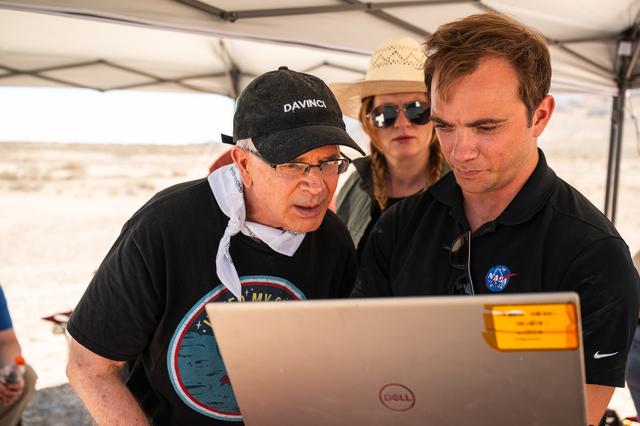
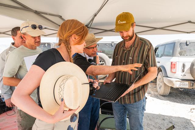
Pictured are DAVINCI’s (left to right) Jim Garvin, mission principal investigator; Erika Kohler, acting deputy principal investigator; and Matthew Mullin, space laser engineer, evaluating flight data in real-time to adapt their future tests…
GSFC_20260623_DV_001166.jpg
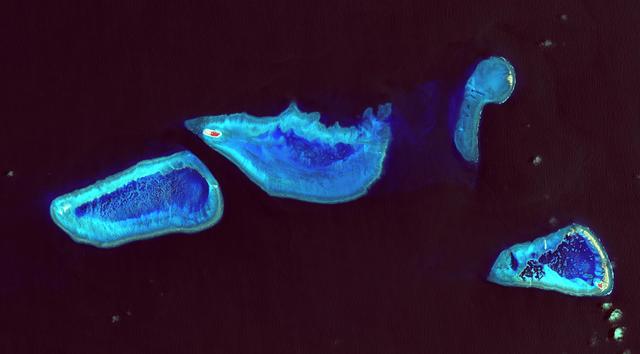
Heron Island is located in Queensland, Australia, approximately 45 miles (72 kilometers) off the Australian mainland, to the northeast of Gladstone. Part of Australia's Great Barrier Reef, the island is an evergreen coral cay surrounded by…
A Bird Eye View of Australia Heron Island
Brent Bos, left, and Jim Garvin, right, watch the helicopter carrying the VADIX payload lift off from Crater Island, Utah, June 23, 2026. VADIX is a test of the camera system that will one day fly aboard NASA’s DAVINCI mission probe to Venu…
GSFC_20260623_DV_001136.jpg
Mike Ravine observes out the helicopter window while in flight over Crater Island, Utah as part of the DAVINCI VADIX experiment, June 23, 2026. NASA/Mike Guinto
GSFC_20260623_DV_001034.jpg
Dr. Jim Garvin makes observations from the window of a helicopter while flying from Wendover Utah to Crater Island, June 23, 2026. The flight was in coordination with the VADIX mission, a preliminary experiment which will demonstrate a prot…
NASA's DAVINCI VADIX Mission
Detailed view of a granite outcrop at Crater Island, Utah on June 23, 2026. This outcropping was one of the points of interest to NASA's DAVINCI VADIX Mission for its distinct geologic properties. NASA/Mike Guinto
GSFC_20260623_DV_000870
The southern half of the island of Okinawa, Japan (26.5N, 128.0E) can be seen in this nearly cloud free view. Okinawa is part of the Ryuku Islands which extend from Taiwan northeastward to Kyushu, southernmost of the Japanese Home Islands.…
Okinawa, Japan
This almost totally cloud free, photo of the island of Timor, Indonesia (9.0S, 125.0E) illustrates the volcanic origin of the over 1500 islands of Indonesia. Close examination of the photo reveals several eroded volcanoes on the Island of T…
Island of Timor, Indonesia
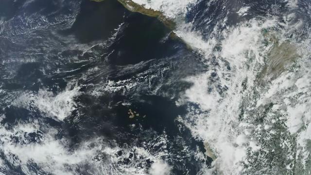
Completed: 07-16-2009  Straddling the equator approximately 1000 kilometers to the west of the South American mainland, the Galapagos Islands lie within the heart of the equatorial current system. Rising from the sea floor, the volcanic isl…
Galapagos Islands Flyby [HD Video]
Mt. Pinatubo on the island of Luzon (15.0N, 120.0E) erupted catastrophically in June 1991 after over 600 years of inactivity. In this vertical view, the full extent of the eruption is obvious. Thick layers of ash completely surrounds the cr…
Mt. Pinatubo Volcano - Post Eruption, Luzon, Philippines
STS054-74-049 (13-19 Jan. 1993) --- St. Croix is the largest, and most industrial of the U.S. Virgin Islands.  This photograph captures St. Croix's features in great detail.  The large industrial complex in the middle of the southern shore…
St. Croix, U.S. Virgin Islands, Caribbean Sea
This image, courtesy of the NASA/ESA Hubble Space Telescope’s Advanced Camera for Surveys (ACS), captures the glow of distant stars within NGC 5264, a dwarf galaxy located just over 15 million light-years away in the constellation of Hydra…
Hubble Spots an Irregular Island in a Sea of Space
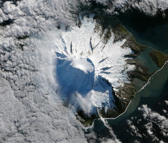
In October 2012, satellites measured subtle signals that suggested volcanic activity on remote Heard Island. These images, captured several months later, show proof of an eruption on Mawson Peak. By April 7, 2013, Mawson's steep-walled summ…
Lava Flow on Mawson Peak, Heard Island
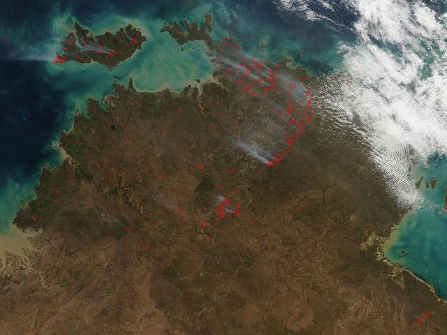
The Aqua satellite collected this natural-color image of fires in Australia with the Moderate Resolution Imaging Spectroradiometer (MODIS) instrument on June 30, 2017.  The image looks at multiple fires and smoke from those fires burning in…
Fires in Australia's Northern Territory and Bathurst Island
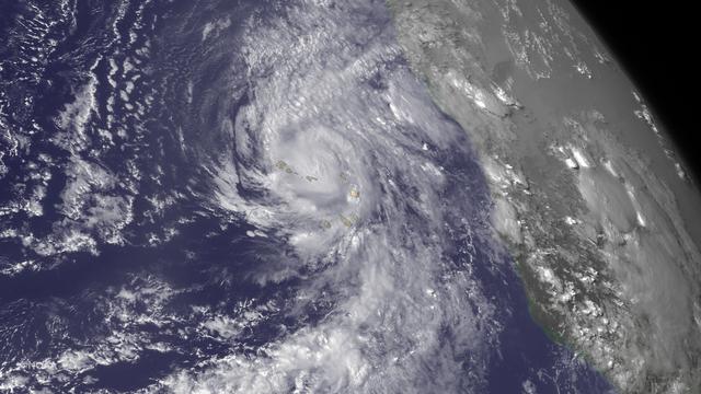
Hurricane Fred is bringing very heavy rains to the Cape Verde Islands. From the National Hurricane Center's Hurricane Fred Forecast Discussion: "According to the official Atlantic tropical cyclone record, which begins in 1851, Fred is…
Hurricane Fred Lashes the Cape Verde Islands
NASA's DC-8 Flying Laboratory taxis up to the ramp at Sal Island's Amilcar Cabral International Airport after a science flight for the NAMMA mission. (Ames photo # ACD06-0135-035)
NASA's DC-8 Flying Laboratory taxis up to the ramp at Sal Island's Amilcar Cabral International Airport after a science flight for the NAMMA mission
Wallops Island camera equipment installed on board the Ames CV-990 (NASA 711) Galileo Airborne platform for the 1971 Barium Ion Cloud Airborne expedition  (experimenters racks)
ARC-1970-AC70-5719-2-8
Dr. Jim Garvin, mission principal investigator, left, and Dr. Erika Kohler, acting deputy principal investigator, right, take measurements of rock samples found at Crater Island, Utah on June 23, 2026. These samples become the "ground truth…
GSFC_20260623_DV_001213.jpg
DAVINCI VADIX team members discuss observations at Crater Island, Utah, June 23, 2026. NASA/Mike Guinto
GSFC_20260623_DV_001222.jpg
Detailed view of a rock outcrop at Crater Island, Utah on June 23, 2026. This outcropping was one of the points of interest to NASA's DAVINCI VADIX Mission for its distinct geologic properties. NASA/Mike Guinto
GSFC_20260623_DV_000982
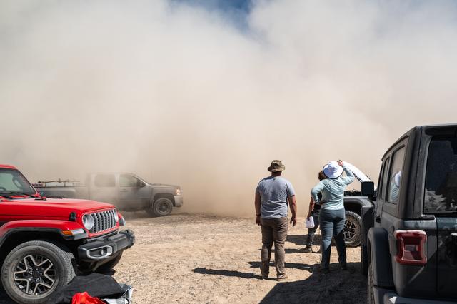
Jason Burt, Lacey Young, and Matt Mullin watch as a helicopter takes off from a test site at Crater Island, June 23, 2026. As the helicopter takes off, it kicks up dust from the ground, reffered to as "roto wash" the dust cloud quickly rise…
GSFC_20260623_DV_001045.jpg
Warren Cain, an instructor at WuDang Martial Arts Center in Huntsville, leads Marshall Pathways intern Donna Cendana of the Engineering Directorate's Propulsion Systems Department, in a demonstration of tai chi, the noncompetitive Eastern m…
2017 Asian American Islander Program
Dr. Jim Garvin presents rock samples found at Crater Island, Utah on June 23, 2026. Dr. Garvin is the principal investigator for NASA's DAVINCI probe which will one day be making discoveries on Venus.
GSFC_20260623_DV_000930
STS026-43-082 (29 Sept. - 3 Oct. 1988) --- This 70mm northerly oriented frame over the Pacific Ocean features the Hawaiian Islands chain. The islands perturb the prevailing northeasterly winds producing extensive cloud wakes in the lee of t…
Hawaiian Island Archipelago
This view of the Malay Peninsula shows the city state of Singapore, Malaysia (1.5N, 104.0E) with all its urban, industrial and commercial land use areas. Singapore is located at the south tip of the Malay peninsula separated by the Johor St…
Singapore, Malaysia
Lake Murray, a manmade reservoir, lies between the Fly and Strickland River Basins, Papua, New Guinea (7.0S, 141.5E). The region, photographed in sunglint, shows the water level in the reservoir and the full extent of the drainage basins of…
Lake Murray, Fly and Strickland River Basins, Papua, New Guinea
STS026-038-056 (29 Sept. - 3 Oct. 1988) --- Tambora Caldera, Sumbawa Island, Indonesia as photographed with a 70mm handheld Hasselblad camera. Tambora is a 6-kilometer-wide and 650-meter-deep Caldera formed in 1815 as a result of a huge vol…
Tambora Caldera, Sumbawa Island, Indonesia
On December 10, 2013 the Moderate Resolution Imaging Spectroradiometer (MODIS) aboard NASA’s Terra satellite flew across the central Atlantic Ocean and captured a true-color image of the Canary Islands.  Lying off of the coast of Western Sa…
Canary Islands
Red and white vapor clouds filled the skies over the Marshall Islands as part of NASA’s Equatorial Vortex Experiment (EVEX).  The red cloud was formed by the release of lithium vapor and the white tracer clouds were formed by the release of…
NASA EVEX Experiment Launches from the Marshall Islands
Cloud vortices off Heard Island, south Indian Ocean.  The Moderate Resolution Imaging Spectroradiometer (MODIS) aboard NASA’s Aqua satellite captured this true-color image of sea ice off Heard Island on Nov 2, 2015 at 5:02 AM EST (09:20 UTC…
Cloud vortices
BO THAO-URABE, A MEMBER OF PRESIDENT BARACK OBAMA’S COMMISSION ON ASIAN AMERICANS AND PACIFIC ISLANDERS, SPOKE TO TEAM MEMBERS OF NASA’S MARSHALL SPACE FLIGHT CENTER DURING AN ASIAN AMERICANS AND PACIFIC ISLANDERS MONTH CELEBRATION EVENT MA…
ASIAN AMERICAN AND PACIFIC ISLANDERS HERITAGE MONTH
Ducks gather in a waterway at NASA's Kennedy Space Center in Florida. Kennedy shares a boundary with the Merritt Island National Wildlife Refuge. The refuge encompasses 140,000 acres that are a habitat for more than 331 species of birds, 31…
Wildlife Photography - Birds
Remote, rugged and extraordinarily beautiful, Alaska’s Aleutian Islands are best known for wildlife reserves, military bases, fishing, furs and fog. The sprawling volcanic archipelago was brought into the spotlight by the Russian-supported…
Aleutian Islands
Pictured are DAVINCI’s (left to right) Mike Ravine, Brent Bos, Erika Kohler, Jim Garvin, and Christian Tate, evaluating flight data in real-time to adapt their future tests to the lessons learned from each flight. The researchers are standi…
GSFC_20260623_DV_001101.jpg
Timberland Helicopter flying the DAVINCI VADIX payload lifts off from Crater Island, Utah, June 23, 2026. NASA/Mike Guinto
GSFC_20260623_DV_001198.jpg
Dr. Jim Garvin, mission principal investigator,collect samples of rocks found at Crater Island, Utah on June 23, 2026. These samples become the "ground truth" for the measurements from the VADIX prototype camera system which flew over the c…
GSFC_20260623_DV_001034.jpg
Mike Ravine, left, Jim Garvin, and Erika Kohler, take direct measurements of rocks observed at Crater Island, Utah as part of the DAVINCI VADIX experiment, June 23, 2026. NASA/Mike Guinto
GSFC_20260623_DV_001225.jpg
The Operational Land Imager (OLI) on Landsat 8 captured this view of a phytoplankton bloom near Alaska’s Pribilof Islands on Sept. 22, 2014. The Pribilofs are surrounded by nutrient-rich waters in the Bering Sea. The milky green and light b…
Coloring the Sea Around the Pribilof Islands
The island of Java (8.0S, 112.0E), perhaps better than any other, illustrates the volcanic origin of Pacific Island groups. Seen in this single view are at least a dozen once active volcano craters. Alignment of the craters even defines the…
Volcanoes, Central Java, Indonesia
Tenarife Island is one of the most volcanically active of the Canary Island archipelago, Atlantic Ocean, just off the NW coast of Africa, (28.5N, 16.5W). The old central caldera, nearly filled in by successive volcanic activity culminating…
Tenarife Island, Canary Island Archipelago, Atlantic Ocean
This distant view of Mt. Fuji, on the main home island of Honshu, Japan (34.0N, 139.0E) was taken from about 450 miles to the south. Evan at that great distance, the majestic and inspiring Mt. Fuji is still plainly visible and easily recogn…
Distant Mt. Fuji, Island of Honshu Japan
STS040-75-003 (5-14 June 1991) --- This image shows several of the Canary Islands, located in the North Atlantic Ocean just west of Africa.  Low level stratus clouds often form here (and along the west coast of continents at these latitudes…
Canary Island Group and von Karman Cloud Vortices.
S65-63150 (16 Dec. 1965) --- Eddies in stratocumulus clouds over the Canary Islands as seen from the Gemini-6 spacecraft during its 14th revolution of Earth. Photo credit: NASA or National Aeronautics and Space Administration
GEMINI-6 - EARTH-SKY - CANARY ISLANDS - OUTER SPACE
On September 24, 2013, a major strike-slip earthquake rattled western Pakistan, killing at least 350 people and leaving more than 100,000 homeless. The 7.7 magnitude quake struck the Baluchistan province of northwestern Pakistan. Amidst the…
Earthquake Births New Island off Pakistan
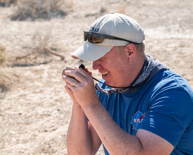
Nick Lang, DAVINCI Science Program Manager at Headquarters NASA, inspects a rock found at Crater Island, Utah during the DAVINCI VADIX experiment, June 23, 2026. NASA/Mike Guinto
GSFC_20260623_DV_001040.jpg
NASA image acquired December 21, 2011  The rugged landscape of the Canary Islands stood out in sharp contrast to the smooth blue waters of the Atlantic Ocean and the flat tan land of northwestern Africa on December 21, 2011, when the Modera…
Canary Islands
The entire Hawaiian Island Archipelago (21.5N, 158.0W) is seen in this single view. The islands are a favorite international resort and tourist attraction drawing visitors from all over the world to enjoy the tropical climate, year round be…
Hawaiian Island Archipelago