
KENNEDY SPACE CENTER, FLA. - Plywood covers the lower windows of the Processing Control Center in the Launch Complex 39 Area in preparation for the arrival of Hurricane Jeanne, expected to impact Central Florida Sunday. This is the fourth h…

KENNEDY SPACE CENTER, FLA. - Large pieces of equipment in the Processing Control Center are covered in plastic in preparation for the arrival of Hurricane Jeanne, expected to impact Central Florida Sunday. This is the fourth hurricane in 45…

KENNEDY SPACE CENTER, FLA. - The work to clean up and secure the roof of the Processing Control Center which sustained damage from Hurricane Frances is under way. The storm's path over Florida took it through Cape Canaveral and KSC propert…

CAPE CANAVERAL, Fla. -- From the Press Site parking lot at NASA's Kennedy Space Center in Florida, the sun sets over the Launch Complex 39 area shadowing the Operations Support Building II, left, Operations Support Building I, Processing Co…

KENNEDY SPACE CENTER, FLA. - In the foreground lies a panel pulled from the wall of the Vehicle Assembly Building at KSC during the category 3 Hurricane Jeanne. The storm barreled through Central Florida Sept. 25-26 from the southeast. Th…

KENNEDY SPACE CENTER, FLA. - The category 3 Hurricane Jeanne barreled through Central Florida Sept. 25-26 from the southeast. This once-pristine beach east of the launch pads on KSC is now littered with debris from the dunes, at left, afte…

This is a visible image of Major Hurricane Matthew taken from NASA's Terra satellite on Oct. 7 at 12 p.m. EDT as it continued moving along Florida's East Coast. Matthew was a Category 3 hurricane at the time of this image. Credit: NASA's Go…

KENNEDY SPACE CENTER, FLA. - Debris litters the railroad track that runs along the shoreline east of KSC’s launch pads. The dunes were assaulted by storm surge and raging winds from category 3 Hurricane Jeanne, which barreled through Centr…

KENNEDY SPACE CENTER, FLA. - A helicopter moves past the Vehicle Assembly Building at KSC following the category 3 Hurricane Jeanne. The storm barreled through Central Florida Sept. 25-26 from the southeast. The VAB had lost 850 panels fr…

On Oct. 19 at 1500 UTC (11 a.m. EDT), the MODIS instrument aboard NASA's Terra satellite captured this visible image of Hurricane Gonzalo east of Newfoundland, Canada. ..Credit: NASA Goddard MODIS Rapid Response Team ..<b><a href="http://w…

On Oct. 23 at 17:30 UTC (1:30 p.m. EDT) the MODIS instrument aboard NASA's Terra satellite saw Hurricane Patricia moving over Mexico. Credit: NASA/GSFC/Jeff Schmaltz/MODIS Land Rapid Response Team <b><a href="http://www.nasa.gov/audience/…
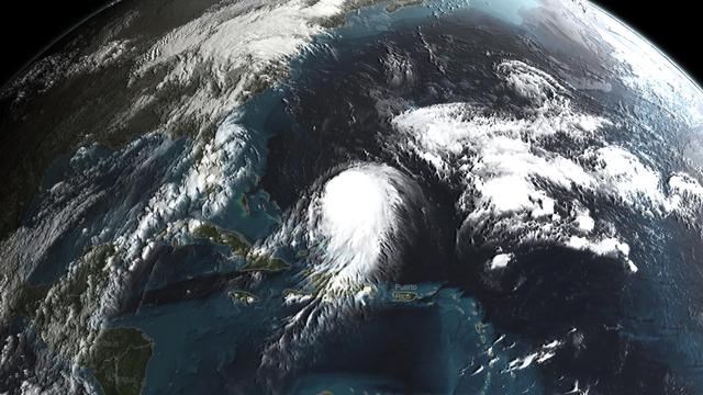
Joaquin became a tropical storm Monday evening (EDT) midway between the Bahamas and Bermuda and has now formed into Hurricane Joaquin, the 3rd of the season--the difference is Joaquin could impact the US East Coast. NASA's GPM satellite ca…
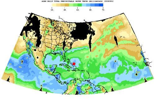
Born in the Atlantic, Hurricane Frances became a category 4 hurricane on August 31, 2004, as seen by the Atmospheric Infrared Sounding System AIRS on NASA Aqua. Expectations are the hurricane will hit the Space Coast of Florida in Brevard C…

DR. EMILY BERNDT USING NEXT GENERATION SATELLITE IMAGERY FOR HURRICANE ANALYSIS

KENNEDY SPACE CENTER, FLA. - Members of a hurricane assessment team from Johnson Space Center and Marshall Space Flight Center tour the roof of the Vehicle Assembly Building (VAB) a week after Hurricane Frances hit the east coast of Cent…

KENNEDY SPACE CENTER, FLA. - A worker covers large pieces of equipment in the Processing Control Center in the Launch Complex 39 Area in preparation for the arrival of Hurricane Jeanne, expected to impact Central Florida Sunday. This is the…

KENNEDY SPACE CENTER, FLA. - KSC employees secure the roof of the Processing Control Center which sustained damage from Hurricane Frances. The storm's path over Florida took it through Cape Canaveral and KSC property during Labor Day weeke…

CAPE CANAVERAL, Fla. -- From the Press Site parking lot at NASA's Kennedy Space Center in Florida, the sun sets over the Launch Complex 39 area. At center, are the Operations Support Building I and Processing Control Center. At right, are t…

Composite image of category 5 Hurricane Patricia, off the Pacific coast of Mexico, from 06:00 UTC on Friday, 23 October 2015. At 8 a.m. EDT on October 23, 2015, the National Hurricane Center said that Hurricane Patricia had grown into a mo…

At about 10:45 p.m. Mountain Daylight Time (MDT) on September 14, 2014, Hurricane Odile made landfall as a Category 3 storm near Cabo San Lucas, Mexico. According to the U.S. National Hurricane Center, Odile arrived with wind speeds of 110…

KENNEDY SPACE CENTER, FLA. - Workers attempt to secure the roof of the Tile Shop in the Thermal Protection System Facility (TPSF) in preparation for Hurricane Jeanne, which is expected to impact Central Florida Sunday. The TPSF, which crea…

KENNEDY SPACE CENTER, FLA. - The second floor of the Thermal Protection System Facility sustained significant damage from Hurricane Frances. The storm's path over Florida took it through Cape Canaveral and KSC property during Labor Day wee…

KENNEDY SPACE CENTER, FLA. - - In the Orbiter Processing Facility, the wheel on Atlantis is covered in plastic that protected it from possible damage by Hurricane Jeanne. The storm barreled through Central Florida Sept. 25-26 from the sou…
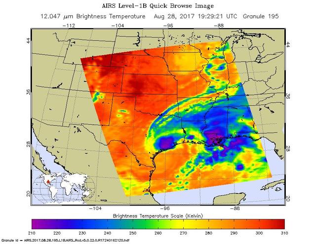
The latest infrared image from NASA's Atmospheric Infrared Sounder (AIRS) instrument aboard NASA's Aqua satellite illustrates the growing flood threat from now Tropical Storm Harvey. In the false-color image, acquired at 2:29 p.m. CDT (19:2…

On Oct. 17 at 15:15 UTC (11:15 a.m EDT) the MODIS instrument aboard NASA's Aqua satellite saw Hurricane Gonzalo's northern quadrant over Bermuda as it moved to landfall. ..Credit: NASA Goddard MODIS Rapid Response Team ..<b><a href="http:/…

Construction work on a new Emergency Operations Center at Stennis Space Center is nearing completion. Construction is expected to be complete by February 2009, with actual occupancy of the building planned for later that year. The new build…

This full-disk image from NOAA’s GOES-13 satellite was captured at 14:45 UTC (10:45 a.m. EDT) and shows Hurricane Patricia off the coast of Mexico on September 23, 2015. At 8 a.m. EDT on October 23, 2015, the National Hurricane Center sai…

The most recent view of Matthew from space shows this massive storm converging on the Florida coast. This visible image was captured Oct. 7 at 4:45 a.m. EDT from NOAA's GOES-East satellite. Read more about Hurricane Matthew at <a href="h…

NASA's Multi-angle Imaging SpectroRadiometer (MISR) passed over Hurricane Florence as it approached the eastern coast of the United States on Thursday, September 13, 2018. At the time the image was acquired, Florence was a large Category 2…
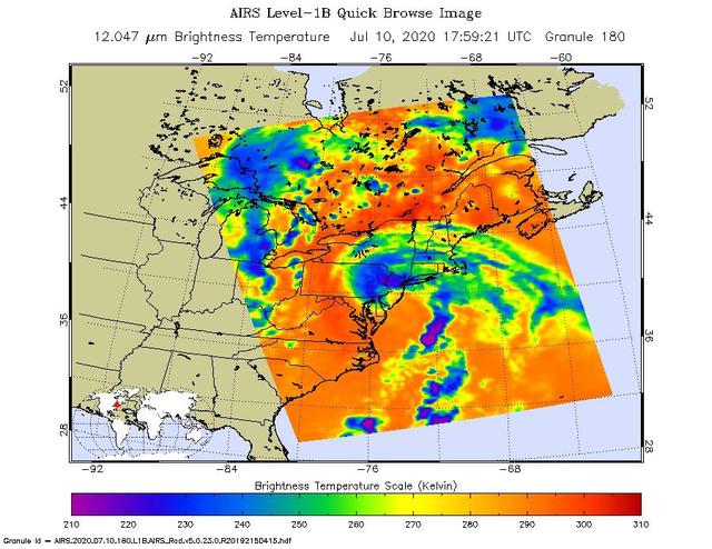
NASA's Atmospheric Infrared Sounder (AIRS) collected this image of Tropical Storm Fay over New England at around 2 p.m. local time on Friday, July 10. The center of the storm made landfall about 10 miles (15 kilometers) north-northeast of A…

KENNEDY SPACE CENTER, FLA. - Large pieces of equipment in the Processing Control Center in the Launch Complex 39 Area are covered in plastic in preparation for the arrival of Hurricane Jeanne, expected to impact Central Florida Sunday. This…

KENNEDY SPACE CENTER, FLA. - KSC employees begin the work to clean up and secure the roof of the Processing Control Center which sustained damage from Hurricane Frances. The storm's path over Florida took it through Cape Canaveral and KSC…

CAPE CANAVERAL, Fla. -- From the Turn Basin at NASA's Kennedy Space Center in Florida, the sun sets over the Launch Complex 39 area. The Operations Support Building II is at left, the Operations Support Building I is at center, and the mamm…
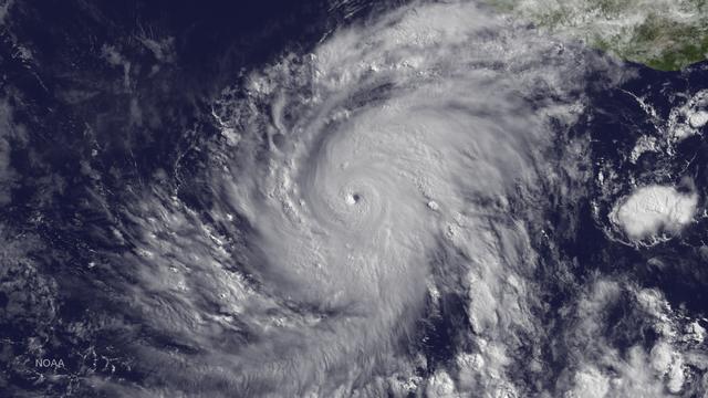
Blanca has rapidly intensified with an increase in wind speed of 60 knots since 1200Z on June 2. The hurricane has developed a distinct pinhole eye in visible images surrounded by very deep convection. There is an opportunity for Blanca to…

Read more from: <a href="http://go.nasa.gov/2duxEeZ" rel="nofollow">go.nasa.gov/2duxEeZ</a> On October 4, 2016, Hurricane Matthew made landfall on southwestern Haiti as a category-4 storm—the strongest storm to hit the Caribbean nation in…

KENNEDY SPACE CENTER, FLA. - This view taken from a helicopter shows damage to the Vehicle Assembly Building at KSC following the category 3 Hurricane Jeanne. The storm barreled through Central Florida Sept. 25-26 from the southeast. The…

KENNEDY SPACE CENTER, FLA. - In preparation for Hurricane Jeanne, a worker places sandbags against the doors of the Space Station Processing Facility while another brings in emergency radios. The hurricane, expected to impact Central Flori…

KENNEDY SPACE CENTER, FLA. - This view shows damage to the Vehicle Assembly Building at KSC following the category 3 Hurricane Jeanne. In the foreground are helicopters that were used for observation flights around the Center. The storm b…

KENNEDY SPACE CENTER, FLA. - This view taken from a helicopter shows damage to the roof of the Vehicle Assembly Building at KSC following the category 3 Hurricane Jeanne. The storm barreled through Central Florida Sept. 25-26 from the sout…

KENNEDY SPACE CENTER, FLA. - A helicopter moves past the Vehicle Assembly Building at KSC following the category 3 Hurricane Jeanne. The storm barreled through Central Florida Sept. 25-26 from the southeast. The VAB had lost 850 panels fr…

KENNEDY SPACE CENTER, FLA. - These sand dunes on the beach east of the KSC launch pads have been ravaged by category 3 Hurricane Jeanne that barreled through Central Florida Sept. 25-26 from the southeast. Jeanne was the fourth hurricane i…

KENNEDY SPACE CENTER, FLA. - This view of the shoreline east of the launch pads at KSC shows the ocean lapping at the base of what appears to be a cliff. The storm surge and raging winds from Hurricane Jeanne eroded the dunes and shoreline…
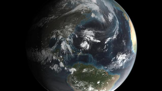
Joaquin became a tropical storm Monday evening (EDT) midway between the Bahamas and Bermuda and has now formed into Hurricane Joaquin, the 3rd of the season--the difference is Joaquin could impact the US East Coast. NASA's GPM satellite ca…
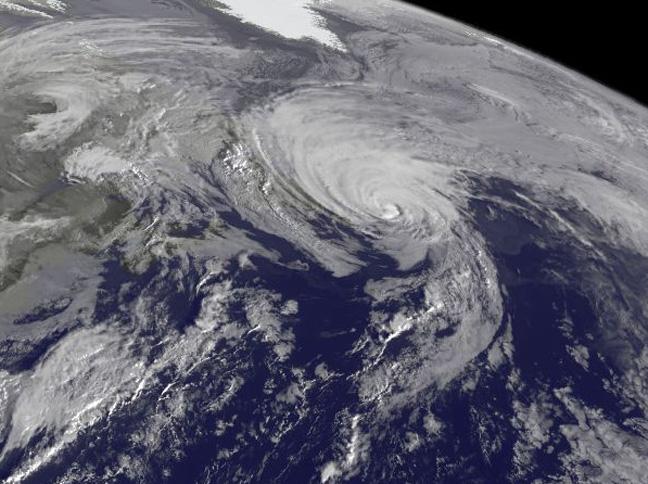
NOAA's GOES-East satellite captured a visible image of the storm on Sunday, Oct. 18 at 1145 UTC (7:45 a.m. EDT) that showed it in the North Atlantic, blanketing eastern Canada and stretching east over open waters. ..Credit: NOAA/NASA GOES P…

Workers install a bulk diesel storage tank for use at Stennis Space Center. Installation of additional diesel storage tanks is part of the center's hurricane-related risk mitigation work.

On Oct. 18 at 17:35 UTC (1:35 p.m EDT) the MODIS instrument aboard NASA's Aqua satellite saw Hurricane Gonzalo approaching Newfoundland. ..Credit: NASA Goddard MODIS Rapid Response Team..<b><a href="http://www.nasa.gov/audience/formedia/fe…
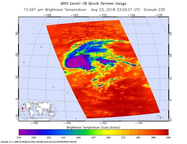
This image shows Hurricane Lane as observed by the Atmospheric Infrared Sounder (AIRS) instrument on NASA's Aqua satellite on Thursday, Aug. 23, 2018. Purple shows very cold clouds high in the atmosphere above the center of the hurricane, b…
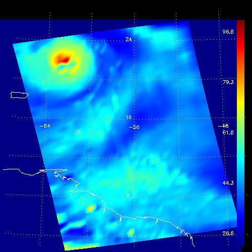
This false-color image shows the amount of atmospheric water vapor observed by AIRS two weeks prior to the passage of Hurricane Isabel, and then when it was a Category 5 storm. The region shown includes parts of South America and the West I…