NASA image acquired July 17, 2011  In mid-July 2011, more than a month after the Missouri River broke through two levees and flooded fields near Hamburg, Iowa, muddy water lingered near the city. Hamburg residents were relieved, however, th…
Flooding near Hamburg, Iowa
NASA image acquired August 4, 2010  Though many areas in northwest Pakistan were bracing for heavy rain and additional flash flooding on August 4, 2010, the city of Kheshgi, in northwest Pakistan, had clear skies. This image, taken by the A…
Flooding in Pakistan August 4, 2010
The Advanced Rapid Imaging and Analysis (ARIA) team at NASA's Jet Propulsion Laboratory in Pasadena, California, created these flood proxy maps depicting areas of Mozambique that are likely flooded as a result of Cyclone Idai. The likely fl…
Satellites Image Mozambique Flooding after Cyclone Idai
SL2-05-397 (22 June 1973) --- New Orleans, Louisiana, Mississippi River, and Lake Pontchartrain (31.0N, 91.0W) can all be seen in this single detailed view. The marshlands of the Atchafalaya Basin, previously the main drainage way for the M…
New Orleans, Louisiana, Mississippi River, and Lake Pontchartrain
Egypt's High Aswan Dam on the Nile River at the first cataracts, Nile River, (24.0N, 33.0E) was completed in 1971 to provide cheap hydroelectric power and to regulate the historically uneven flow of the Nile River. The contrast between the…
Nile River, Lake Nasser, Aswan Dam, Egypt
This image acquired on Jan. 17, 2016 by NASA Terra spacecraft shows major flooding along the Mississippi River, affecting Missouri, Illinois, Arkansas and Tennessee. As of January 17, flood warnings were issued for the area around Baton Rou…
Flooding on the Mississippi River Captured by NASA Spacecraft
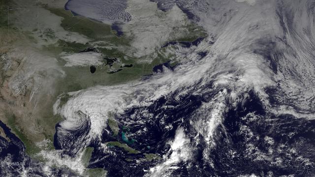
The system that brought heavy rainfall and flash flooding to parts of the southern Plains and western Gulf Coast over the past several days continues to push eastward, with the greatest potential for heavy rain and flash flooding on Monday…
Heavy Rain, Flash Flooding Possible Across Parts of Lower Mississippi Valley, Southeast
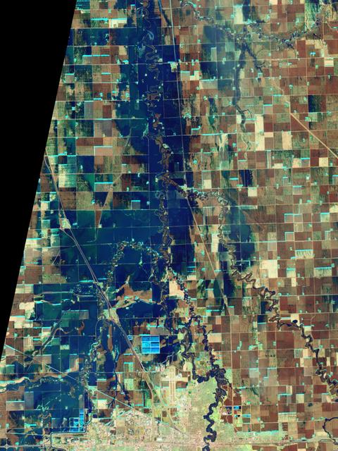
NASA Satellite image acquired March 21, 2010.  To see a high res more detail of this image go here:  <a href="http://www.flickr.com/photos/gsfc/4455125023/in/photostream/">www.flickr.com/photos/gsfc/4455125023/in/photostream/</a>  On March…
Red River Flooding in North Dakota (high res)
This NOAA GOES-East satellite animation shows the development of System 91L into Tropical Storm Andrea over the course of 3 days from June 4 to June 6, just after Andrea was officially designated a tropical storm.   Credit:  NASA's GOES Pro…
NASA Sees Heavy Rainfall in Tropical Storm Andrea
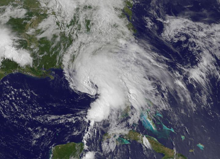
NASA’s Terra satellite passed over Tropical Storm Andrea on June 5 at 16:25 UTC (12:25 p.m. EDT) and the MODIS instrument captured this visible image of the storm. Andrea’s clouds had already extended over more than half of Florida.    Cred…
NASA Sees Heavy Rainfall in Tropical Storm Andrea
North America was almost entirely above its long-term average in mass in May 2019, due to Midwestern flooding, with the runoff raising the Great Lakes to record levels.  https://photojournal.jpl.nasa.gov/catalog/PIA22840
Changes in Mass, North America
Since August 2015, heavy rains have caused rivers to overflow and forced tens of thousands from their homes in Paraguay, Argentina and Brazil. Rosario, Argentina is located 186 miles (300 kilometers) northwest of Buenos Aires, on the wester…
Argentine Flooding Observed by NASA Satellite
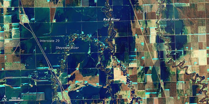
NASA Satellite image acquired March 21, 2010.  To see a high res of this image go here:  <a href="http://www.flickr.com/photos/gsfc/4455124807/in/photostream/">www.flickr.com/photos/gsfc/4455124807/in/photostream/</a>  On March 21, 2010, th…
Red River Flooding in North Dakota
The Advanced Rapid Imaging and Analysis (ARIA) team at NASA's Jet Propulsion Laboratory in Pasadena, California, in collaboration with the Earth Observatory of Singapore (EOS), created this flood map depicting areas of the Bahamas that are…
Flooding from Dorian Seen from Space
At its founding, the Marshall Space Flight Center (MSFC) inherited the Army’s Jupiter and Redstone test stands, but much larger facilities were needed for the giant stages of the Saturn V. From 1960 to 1964, the existing stands were remodel…
Around Marshall
STS040-614-061 (5-14 June 1991) --- Albuquerque, New Mexico is perched on the edge of the Rio Grande floodplain, which crosses the photograph from upper left to center lower right.  The reddish-brown surface of the Albuquerque Basin, a faul…
Albuquerque, NM, USA
Image acquired February 27, 2010: An extratropical cyclone named Xynthia brought hurricane-force winds and high waves to Western Europe at the end of February 2010, CNN reported. Winds as fast as 200 kilometers (125 miles) per hour reached…
Violent Storm Strikes Western Europe
No more images