On Sunday, Nov. 12, 2017, a magnitude 7.3 earthquake struck along the Iran-Iraq border near Halabjah, Iraq. The earthquake was felt as far away as Kuwait, Qatar, Turkey, Lebanon and Israel. Extensive damage and numerous casualties were repo…
Iran-Iraq Border Quake Region Imaged by NASA Satellite
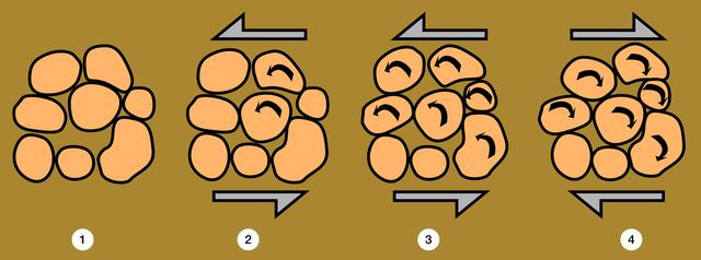
The packing of particles can change radically during cyclic loading such as in an earthquake or when shaking a container to compact a powder. A large hole (1) is maintained by the particles sticking to each other. A small, counterclockwise…
Microgravity
CT scans of the specimens on STS-79 reveal internal cone-shaped features and radial patterns not seen in specimens processed on the ground. The lighter areas are the densest in these images. CT scans produced richly detailed images allowing…
Microgravity
Ground shaking triggered liquefaction in a subsurface layer of water-saturated sand, producing differential lateral and vertical movement in a overlying carapace of unliquified sand and slit, which moved from right to left towards the Pajar…
Microgravity
An automobile lies crushed under the third story of this apartment building in the Marina District after the Oct. 17, 1989, Loma Prieta earthquake. The ground levels are no longer visible because of structural failure and sinking due to liq…
Microgravity
What appear to be boulders fresh from a tumble down a mountain are really grains of Ottawa sand, a standard material used in civil engineering tests and also used in the Mechanics of Granular Materials (MGM) experiment. The craggy surface s…
Microgravity
What appear to be boulders fresh from a tumble down a mountain are really grains of Ottawa sand, a standard material used in civil engineering tests and also used in the Mechanics of Granular Materials (MGM) experiment. The craggy surface s…
Microgravity
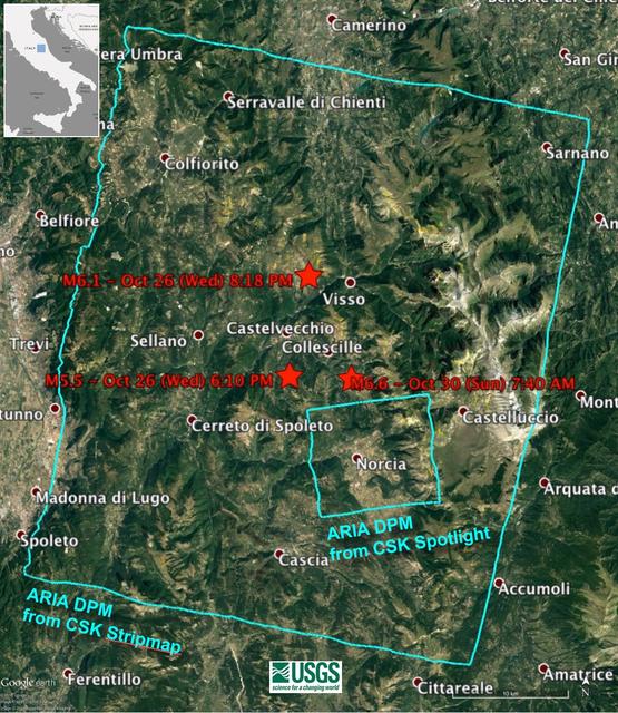
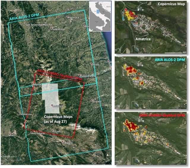
Damage Proxy Map (DPM) v0.5, derived from the Italian Space Agency's COSMO-SkyMed Spotlight synthetic aperture radar (SAR) data acquired from an ascending orbit, covering an area of 6.2-by-6.2 miles (10-by-10 kilometers), centered at Norcia…
Damage Map of Latest Italian Quake Produced by NASA
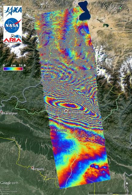
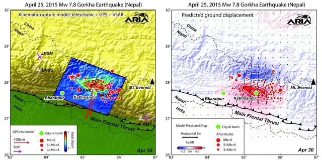
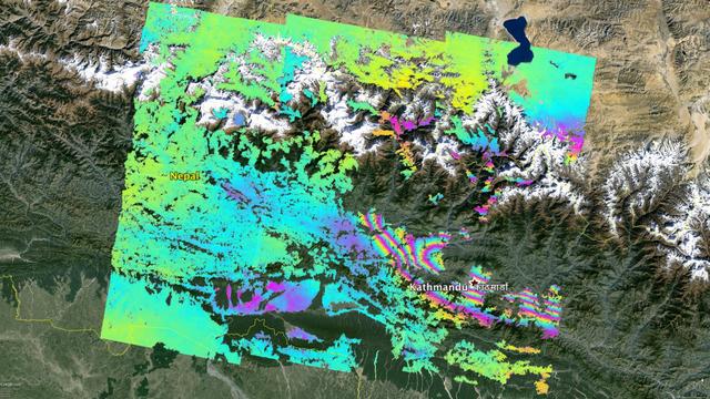
NASA and its partners are contributing important observations and expertise to the ongoing response to the April 25, 2015, magnitude 7.8 Gorkha earthquake in Nepal. The quake was the strongest to occur in that area since the 1934 Nepal-Biha…
NASA ARIA Project Provides New Look at Earth Surface Deformation from Nepal Quake
C-20A crew chief Isac Mata stows metal pins used to secure the landing gear, while Ian Elkin, operations engineer, boards the aircraft to prepare for takeoff from NASA’s Armstrong Flight Research Center in Edwards, California, on Wednesday,…
NASA C-20A Enables Missions Advancing Earthquake Science
NASA’s C-20A takes off from NASA’s Armstrong Flight Research Center in Edwards, California, on Wednesday, April 29, 2026. The aircraft conducted science flights over Central California carrying NASA’s UAVSAR (Uninhabited Aerial Vehicle Synt…
NASA C-20A Enables Missions Advancing Earthquake Science
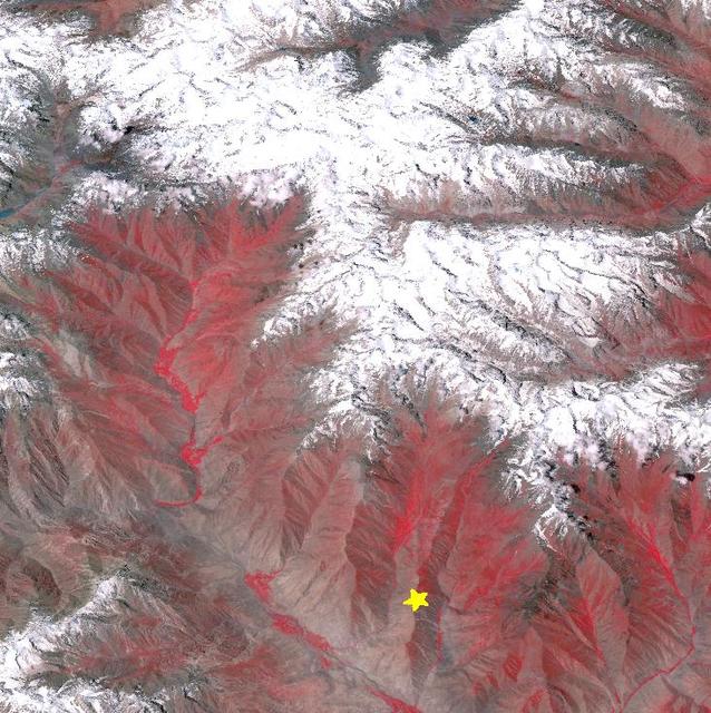
On Oct. 26, 2015, NASA Terra spacecraft acquired this image of northeastern Afghanistan where a magnitude 7.5 earthquake struck the Hindu Kush region.  The earthquake's epicenter was at a depth of 130 miles (210 kilometers), on a probable s…
Earthquake in Hindu Kush Region, Afghanistan
Sand boil or sand volcano measuring 2 m (6.6 ft.) in length erupted in median of Interstate Highway 80 west of the Bay Bridge toll plaza when ground shaking transformed loose water-saturated deposit of subsurface sand into a sand-water slur…
Microgravity
Key persornel in the Mechanics of Granular Materials (MGM) experiment include Khalid Alshibli, project scientist at NASA's Marshall Space Flight Center (MSFC). Sand and soil grains have faces that can cause friction as they roll and slide a…
Microgravity
On April 9, 2013 at 11:52 GMT, a magnitude 6.3 earthquake hit southwestern Iran's Bushehr province near the town of Kaki. Preliminary information is that several villages have been destroyed and many people have died, as reported by BBC New…
NASA Spacecraft Image Shows Location of Iranian Earthquake
Using a combination of GPS-measured ground motion data, satellite radar data, and seismic observations from instruments distributed around the world, scientists have constructed preliminary estimates of how much the fault responsible for th…
NASA/Caltech Team Images Nepal Quake Fault Rupture, Surface Movements
Amatrice earthquake in central Italy, which caused widespread building damage to several towns throughout the region. This earthquake was the strongest in that area since the 2009 earthquake that destroyed the city of L'Aquila.  The Advance…
Automated Radar Image of Deformation for Amatrice, Italy Earthquake
The Advanced Rapid Imaging and Analysis (ARIA) team at NASA's Jet Propulsion Laboratory in Pasadena, California, and Caltech, also in Pasadena, created this Damage Proxy Map (DPM) depicting areas in the northeastern part of Lombok Island, I…
ARIA Damage Proxy Map of Lombok, Indonesia Earthquakes
Lunar Orbiter 2 oblique northward view towards Copernicus crater on the Moon shows crater wall slumping caused by soil liquefaction following the impact that formed the crater. The crater is about 100 km in diameter. The central peaks are v…
Microgravity
Italy earthquake. The quake has caused significant damage in the historic town of Amatrice.  To assist in the disaster response efforts, scientists at NASA's Jet Propulsion Laboratory, Pasadena, California, and the California Institute of T…
New Satellite Damage Maps Assist Italy Earthquake Disaster Response
NASA's Aqua satellite passed over Japan one hour and 41 minutes before the quake hit. At the time Aqua passed overhead, the Moderate Resolution Imaging Spectroradiometer (MODIS) instrument captured a visible of Japan covered by clouds. The…
NASA Satellite Image of Japan Captured March 11, 2011
NASA’s C-20A takes off from NASA’s Armstrong Flight Research Center in Edwards, California, on Wednesday, April 29, 2026. The aircraft conducted science flights over Central California carrying NASA’s UAVSAR (Uninhabited Aerial Vehicle Synt…
NASA C-20A Enables Missions Advancing Earthquake Science
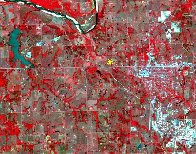
On Sunday, Nov. 6, 2016, at 7:44 p.m. local time, a magnitude 5.0 earthquake struck near the town of Cushing, Oklahoma. Numerous buildings were damaged by the temblor, but only a few minor injuries were reported. Cushing is home to one of t…
Oklahoma Area Struck By Magnitude 5.0 Earthquake Imaged by NASA Satellite
Key persornel in the Mechanics of Granular Materials (MGM) experiment at the University of Colorado at Boulder include Tawnya Ferbiak (software engineer), Susan Batiste (research assistant), and Christina Winkler (graduate research assistan…
Microgravity
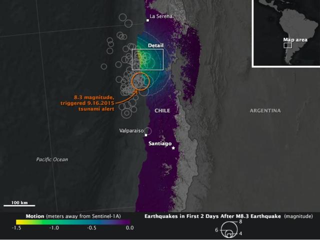
On Sept. 16, 2015, a magnitude 8.3 earthquake struck near the coast of central Chile along the boundary of the Nazca and South American tectonic plates. Dubbed the Illapel earthquake, the shaking lasted at least three minutes and propelled…
NASA Looks at Land Surface Changes Following Chilean Quake
Key persornel in the Mechanics of Granular Materials (MGM) experiment are Mark Lankton (Program Manager at University Colorado at Boulder), Susan Batiste (research assistance, UCB), and Stein Sture (principal investigator). Sand and soil gr…
Microgravity
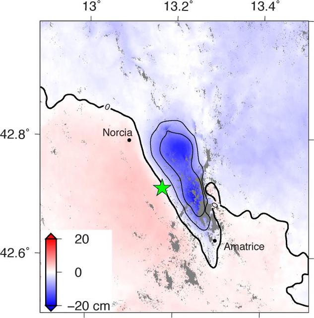
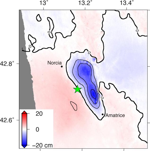
NASA and its partners are contributing observations and expertise to the ongoing response to the Aug. 23, 2016, magnitude 6.2 Amatrice earthquake in central Italy caused widespread building damage to several towns throughout the region. Thi…
Radar Shows Italy Area Moved 8 Inches by Amatrice Earthquake
On September 24, 2013, a major strike-slip earthquake rattled western Pakistan, killing at least 350 people and leaving more than 100,000 homeless. The 7.7 magnitude quake struck the Baluchistan province of northwestern Pakistan. Amidst the…
Earthquake Births New Island off Pakistan
NASA and its partners are contributing important observations and expertise to the ongoing response to the Sept. 7, 2017 (local time), magnitude 8.1 Oaxaca-Chiapas earthquake in Mexico. This earthquake was the strongest in more than a centu…
Sentinel-1 Radar Shows Ground Motion From Sept. 2017 Oaxaca-Chiapas, Mexico Quake
NASA and its partners are contributing important observations and expertise to the ongoing response to the April 25, 2015, magnitude 7.8 Gorkha earthquake in Nepal. The quake was the strongest to occur in that area since the 1934 Nepal-Biha…
NASA ARIA Project Maps Deformation of Earth Surface from Nepal Quake
The Advanced Rapid Imaging and Analysis (ARIA) team at NASA's Jet Propulsion Laboratory in Pasadena, California, and Caltech, also in Pasadena, created this Damage Proxy Map (DPM) depicting areas of Central Mexico, including Mexico City, th…
Satellite Radar Detects Damage from Sept. 19, 2017 Raboso, Mexico, Quake
The Advanced Rapid Imaging and Analysis (ARIA) team at NASA's Jet Propulsion Laboratory in Pasadena, California, and Caltech, also in Pasadena, created this Damage Proxy Map (DPM) depicting areas of Southern Mexico that are likely damaged (…
Satellite Radar Detects Damage from Sept. 2017 Chiapas, Mexico Quake
On September 24 at 11:29 GMT, a magnitude 7.7 earthquake struck in south-central Pakistan at a relatively shallow depth of 20 kilometers. The earthquake occurred as the result of oblique strike-slip motion, consistent with rupture within th…
Region Hit by Large Pakistan Quake as Shown by NASA Spacecraft
Alvin Mitchell, a NASA C-20A aircraft quality assurance inspector, completes preflight checks at NASA’s Armstrong Flight Research Center in Edwards, California, on Wednesday, April 29, 2026. The aircraft conducted science flights over Centr…
NASA C-20A Enables Missions Advancing Earthquake Science
NASA’s C-20A takes off from NASA’s Armstrong Flight Research Center in Edwards, California, on Wednesday, April 29, 2026. The aircraft conducted science flights over Central California carrying NASA’s UAVSAR (Uninhabited Aerial Vehicle Synt…
NASA C-20A Enables Missions Advancing Earthquake Science
No more images