Researchers at NASA's Jet Propulsion Laboratory in Southern California used data from an airborne radar to measure the movement of the slow-moving landslides on the Palos Verdes Peninsula in Los Angeles County. The analysis determined…
NASA Radar Looks at Palos Verdes Landslides
      This visualization shows sea surface height measurements of the Gulf Stream off the coast of North Carolina and Virginia. The data was collected on Jan. 21, 2023, by seven satellites currently in operation. The information, provided b…
Sea Level Visualization of Gulf Stream
An oil slick from naturally occurring oil seeps off the coast of Santa Barbara, California. The NASA-NOAA Marine Oil Spill Thickness (MOST) project is using the area to test the ability of a radar instrument called UAVSAR to detect the thic…
Natural Oil Seepage Off California Coast
This map of Antarctica shows the changes in the elevation of the Antarctic ice sheet from 1985 through 2021. The map is part of a study, published in Earth System Science Data, conducted by researchers at NASA's Jet Propulsion Laboratory in…
The Antarctic Ice Sheet's Changing Height
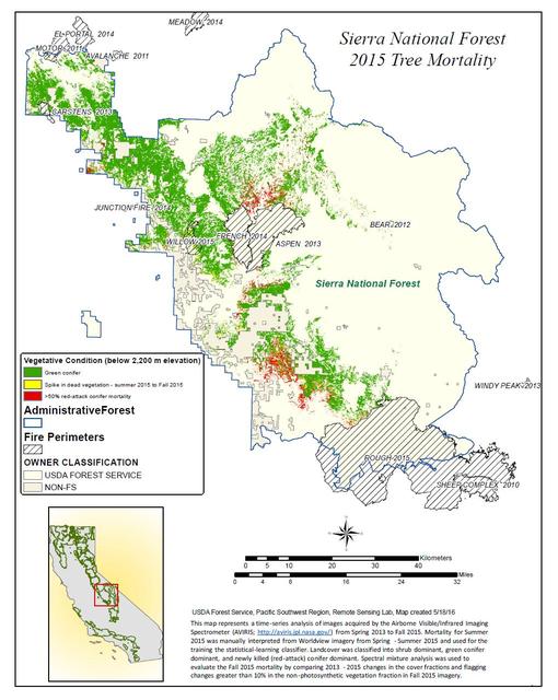
California, reveals the devastating effect of California's ongoing drought on Sierra Nevada conifer forests.  The map will be used to help the U.S. Forest Service assess and respond to the impacts of increased tree mortality caused by the d…
California Drought Effects on Sierra Trees Mapped by NASA
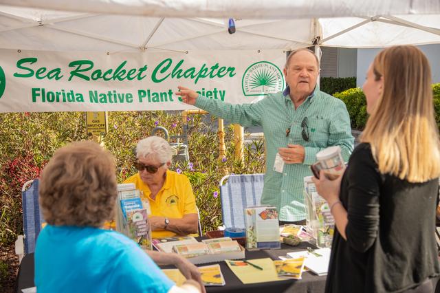
Members of the Florida Native Plant Society converse with visitors during a sustainability expo held at the Kennedy Space Center Visitor Complex in Florida on April 11, 2019. The expo kicked off Kennedy’s annual Earth Day celebrations. The…
Earth Day Blog Post
Guests view a display set up by Hubbs-Seaworld Research Institute during a sustainability expo held at the Kennedy Space Center Visitor Complex in Florida on April 11, 2019. The expo kicked off Kennedy’s annual Earth Day celebrations, where…
Earth Day Blog Post
Kennedy Space Center kicked off its annual Earth Day celebrations with a sustainability expo at the center’s visitor complex in Florida on April 11, 2019. Approximately 40 exhibitors from across the nation assembled to provide information r…
Earth Day Blog Post
This image shows Iceland volcanic eruption monitored by NASA EO-1 spacecraft. To the south is the edge of Dyngjujökull and to the north is the volcano called Askja.
Iceland Volcanic Eruption Monitored by NASA EO-1 Spacecraft
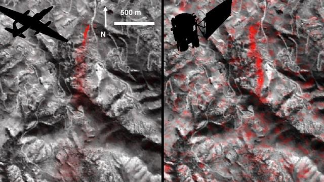
NASA's Airborne Visible Infrared Imaging Spectrometer instrument (AVIRIS), flying aboard a NASA Armstrong Flight Research Center high-altitude ER-2 aircraft, flew over the wildfires burning in Southern California on Dec. 5, 2017 and acquire…
NASA's AVIRIS Instrument Sheds New Light on Southern California Wildfires
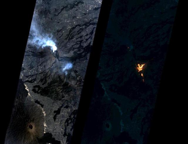
Momotombo volcano, Nicaragua, began erupting on Dec. 1, 2015, after more than a century of inactivity. On Dec. 4, 2015, the Advanced Land Imager (ALI) on NASA's Earth Observing 1 (EO-1) spacecraft observed the new eruption. This image is cr…
Nicaragua Eruption Lava Threat Closely Monitored by NASA EO-1 Spacecraft
On the night of Sept. 6, 2014 NASA Earth Observing 1 EO-1 spacecraft observed the ongoing eruption at Holuhraun, Iceland. Partially covered by clouds, this scene shows the extent of the lava flows that have been erupting.
Progress of Icelandic Lava Flows Charted by NASA EO-1 Spacecraft
This image from NASA Terra spacecraft shows a perspective view, looking toward the Aso volcanic caldera, which indicates the epicenter with a red star.
NASA Satellite Shows Site of Devastating Japan Quakes
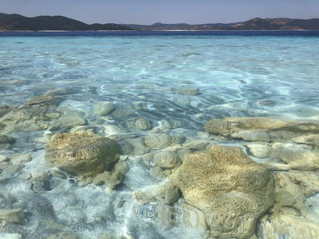
The rocks seen here along the shoreline of Lake Salda in Turkey were formed over time by microbes that trap minerals and sediments in the water. These so-called microbialites were once a major form of life on Earth and provide some of the o…
Lake Salda Rocks
      Researchers from NASA's Jet Propulsion Laboratory in Southern California and Rutgers University in New Jersey produced this map in their analysis of upward and downward vertical land motion – also known as uplift and subsidence – acro…
Map of New York City Subsidence and Uplift
      A February 2023 study by researchers at NASA's Jet Propulsion Laboratory in Southern California analyzed data on atmospheric methane concentrations from ground-based sensors scattered around four densely populated Southern California…
Declining Methane Emissions in the Los Angeles Basin
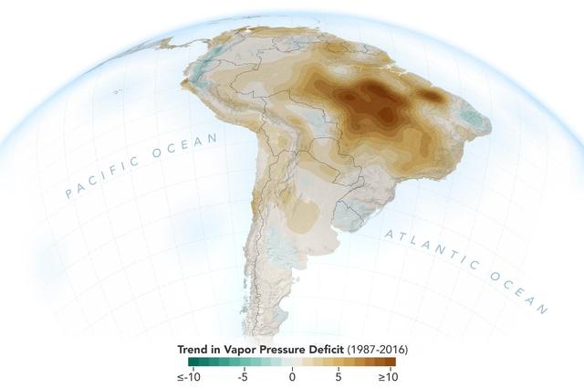
The image shows the trend of vapor pressure deficit over the Amazon rainforest during the dry season months — August through October — from 1987 to 2016. The measurements are shown in millibars — a standard unit of measure for atmospheric p…
New Study Shows Atmosphere in the Amazon Drying Out
Over the past 30 years, global average sea level has risen a total of 3.6 inches (9.1 centimeters), as indicated in this graphic, which is based on sea level measurements (in blue) from five successive satellites starting with the U.S.-Fren…
30 Years of Sea Level Rise
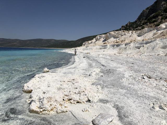
The eastern shore of Lake Salda in Turkey is a good analog for what an ancient lake may have looked like at Jezero Carter on Mars. The white sands and rocks are carbonate minerals that precipitated in the lake. The terraces on the right are…
Lake Salda Beach
Atmospheric methane is a potent greenhouse gas, but the percentage of it produced through human activities is still poorly understood. Future instruments on orbiting satellites can help address this issue by surveying human-produced methane…
A First: NASA Spots Single Methane Leak from Space
Visitors participate in one of many butterfly releases held throughout the day at the Kennedy Space Center’s sustainability expo on April 11, 2019. Held at the center’s visitor complex in Florida, the expo kicked off Kennedy’s annual Earth…
Earth Day Blog Post
Kennedy Space Center kicked off its annual Earth Day celebrations with a sustainability expo at the center’s visitor complex in Florida on April 11, 2019. Approximately 40 exhibitors from across the nation assembled to provide information r…
Earth Day Blog Post
A member of Brevard Backyard Beekeepers is photographed in front of her display during a sustainability expo held at the Kennedy Space Center Visitor Complex in Florida on April 11, 2019. The expo kicked off Kennedy’s annual Earth Day celeb…
Earth Day Blog Post
A butterfly sits in the palm of a visitor’s hand at the Kennedy Space Center Visitor Complex in Florida. Kennedy kicked of its annual Earth Day celebrations with a sustainability expo at the visitor complex on April 11, 2019, where butterfl…
Earth Day Blog Post
A visitor transfers a butterfly to a cluster of flowers during one of many butterfly releases held throughout the day at the Kennedy Space Center’s sustainability expo on April 11, 2019. Held at the center’s visitor complex in Florida, the…
Earth Day Blog Post
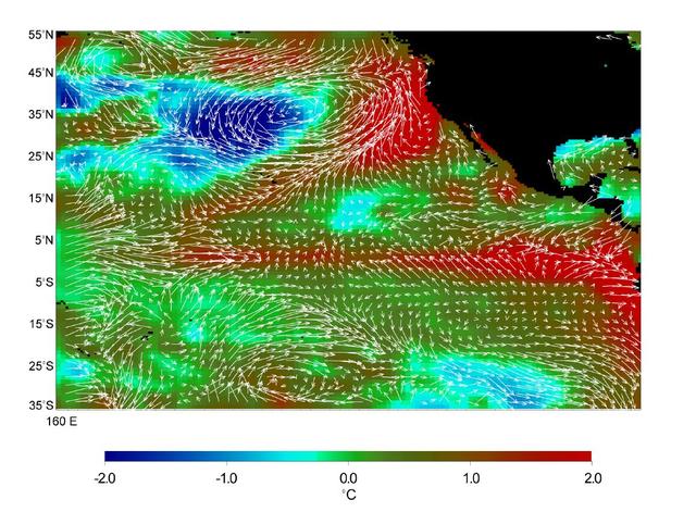
This image displays wind measurements taken by the satellite-borne NASA Scatterometer NSCAT during the last 10 days of May 1997, showing the relationship between the ocean and the atmosphere at the onset of the 1997-98 El Niño condition.
Microwave Limb Sounder/El Niño Watch - 1997 Research Data Reveal Clues about El Niño Influence
NASA's Airborne Visible Infrared Imaging Spectrometer instrument (AVIRIS), flying aboard a NASA Armstrong Flight Research Center high-altitude ER-2 aircraft, observed wildfires burning in Southern California on Dec. 5-7, 2017. AVIRIS is an…
Multiple Aspects of the Southern California Wildfires as Seen by NASA's AVIRIS
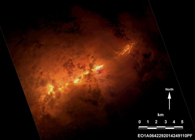
On Jan. 24, 2017, the Hyperion Imager on NASA's Earth Observing 1 (EO-1) spacecraft observed a new eruption at Erta'Ale volcano, Ethiopia, from an altitude of 438 miles (705 kilometers). Data were collected at a resolution of 98 feet (30 me…
NASA Spacecraft Watches as Eruption Reshapes African Volcano
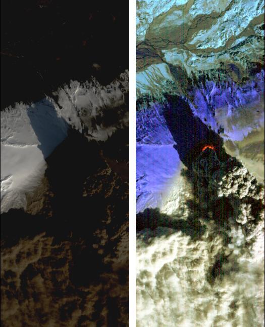
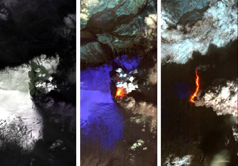
On Saturday, April 17, 2010, NASA Earth Observing-1 EO-1 spacecraft obtained this pair of images of the continuing eruption of Iceland Eyjafjallajökull volcano. On the left, new black ash deposits are visible on the ground.
NASA Satellite Eyes Iceland Volcano Cauldron
The Advanced Land Imager onboard NASA Earth Observing-1 EO-1 spacecraft obtained this false-color infrared image of Iceland Eyjafjallajökull volcano on April 17, 2010. A strong thermal source is visible at the base of the Eyjafjallajökull p…
NASA Satellite Observes Iceland Eyjafjallajökull Volcano in Infrared
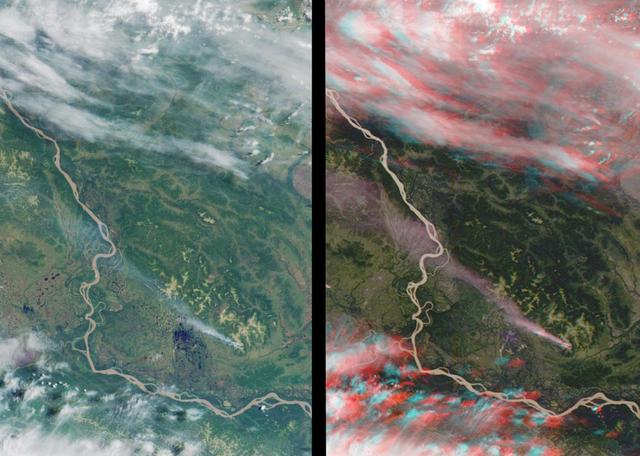
This stereo view of western Alaska was acquired by NASA Terra satellite on June 25, 2000. 3D glasses are necessary to view this image.
MISR Stereo Imaging Distinguishes Smoke from Cloud
These holes, captured on Alaska's Matanuska Glacier in July 2012, are formed by cryoconite – dust particles that melt into the ice over time, eventually forming small pockets of water below the glacier's surface. Scientists believe similar…
Cryoconite Holes on Matanuska Glacier
      Using radars on the ESA (European Space Agency) Sentinel-1 satellites, along with advanced data processing techniques, a team of researchers measured upward and downward vertical land motion – also known as uplift and subsidence – acr…
Hot Spots of Subsidence, Uplift in New York City
This 1969 artist's concept illustrates the use of three major elements of NASA's Integrated program, as proposed by President Nixon's Space Task Group. In Phases I and II, a Space Tug with a manipulator-equipped crew module removes a cargo…
Early Program Development
      A March 2023 study by researchers at NASA's Jet Propulsion Laboratory in Southern California compared emissions from a belt of oil refineries across the South Bay area of Los Angeles during the first summer of the COVID-19 pandemic to…
Declining Methane Emissions at California Oil Fields and Refineries
A paper led by researchers at NASA's Jet Propulsion Laboratory estimates the total volume of water in Earth's rivers – called river storage – on average between 1980 and 2009, and maps out the results for the planet's major hydrological reg…
Global Accounting of Earth's River Storage and Flow
      Researchers from NASA's Jet Propulsion Laboratory in Southern California and the National Oceanic and Atmospheric Administration (NOAA) analyzed vertical land motion – also known as uplift and subsidence – along the California coast b…
Map of California Subsidence and Uplift
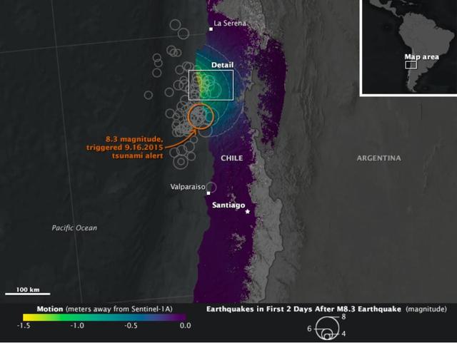
On Sept. 16, 2015, a magnitude 8.3 earthquake struck near the coast of central Chile along the boundary of the Nazca and South American tectonic plates. Dubbed the Illapel earthquake, the shaking lasted at least three minutes and propelled…
NASA Looks at Land Surface Changes Following Chilean Quake
A newly released butterfly sits in a cluster of flowers at the Kennedy Space Center Visitor Complex. Kennedy kicked off its annual Earth Day celebrations with a sustainability expo at the center’s visitor complex in Florida on April 11, 201…
Earth Day Blog Post
Volunteers from the Merritt Island National Wildlife Refuge are photographed with their display during a sustainability expo held at the Kennedy Space Center Visitor Complex in Florida on April 11, 2019. Guests had the opportunity to view t…
Earth Day Blog Post
A butterfly perches on a visitor’s finger at the Kennedy Space Center Visitor Complex in Florida. Kennedy kicked off its annual Earth Day celebrations with a sustainability expo at the visitor complex on April 11, 2019, where butterflies we…
Earth Day Blog Post
A newly released butterfly sits in a cluster of flowers at the Kennedy Space Center Visitor Complex. Kennedy kicked off its annual Earth Day celebrations with a sustainability expo at the center’s visitor complex in Florida on April 11, 201…
Earth Day Blog Post
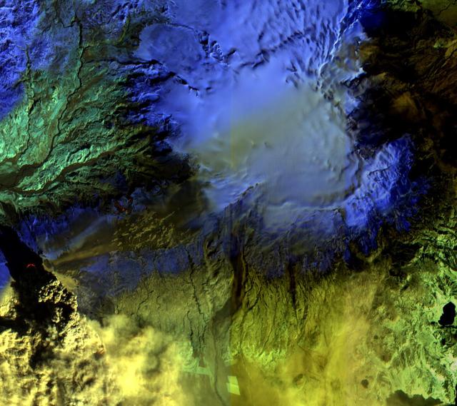
Dramatic changes have been observed at the Eyjafjallajökull volcano in Iceland by NASA's Earth Observing 1 (EO-1) spacecraft. On May 2, 2010, the Hyperion hyperspectral imager on EO-1 imaged Eyjafjallajökull and identified the extent of a l…
Iceland Volcano Puffs Ash as Lava Flow Cuts Through Eyjafjallajökull Icecap
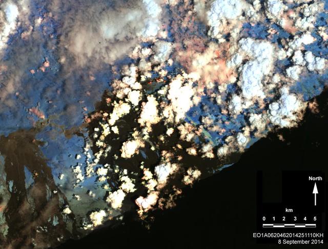
On Sept. 8, 2014, NASA Earth Observing 1 spacecraft obtained this infrared image of Kilauea volcano, Hawaii, which has been in continuous eruption since 1983. New lava flows can be seen.
Hawaii Lava Threat Closely Monitored by NASA EO-1 Spacecraft
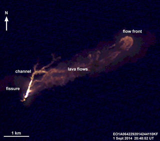
On the night of Sept. 1, 2014, NASA Earth Observing 1 EO-1 spacecraft observed the ongoing eruption at Holuhraun, Iceland. This false-color image that emphasizes the hottest areas of the vent and resulting lava flows.
NASA Spacecraft Eyes Iceland Volcanic Eruption
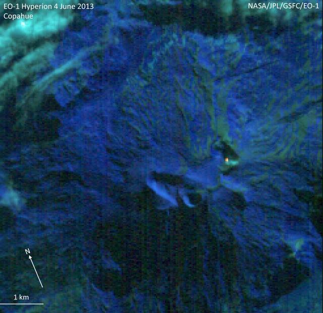
NASA Earth Observing-1 EO-1 spacecraft observed Copahue volcano, a 2965 meter high volcano on the Chile-Argentina border, on Jun. 4, 2013. Having recently displayed signs of unrest, the volcano is under close scrutiny by local volcanologist…
NASA Earth Observing-1 Keeps Watchful Eye on South American Volcano Copahue
On June 14, 2011, NASA Earth Observing-1 EO-1 spacecraft obtained this image showing ash-rich volcanic plume billowing out of the vent, punching through a low cloud layer. The plume grey color is a reflection of its ash content.
NASA EO-1 Spacecraft Images Chile Volcanic Eruption
On Feb. 13, 2014, violent eruption of Kelud stratovolcano in Java, Indonesia sent volcanic ash covering an area of 70,000 square miles, prompting the evacuation of tens of thousands of people. This image is from NASA Terra spacecraft.
Ashy Aftermath of Indonesian Volcano Eruption seen by NASA Spacecraft