This February 8, 2016 composite image reveals the complex distribution of phytoplankton in one of Earth's eastern boundary upwelling systems — the California Current. Recent work suggests that our warming climate my be increasing the intens…
The California Current System
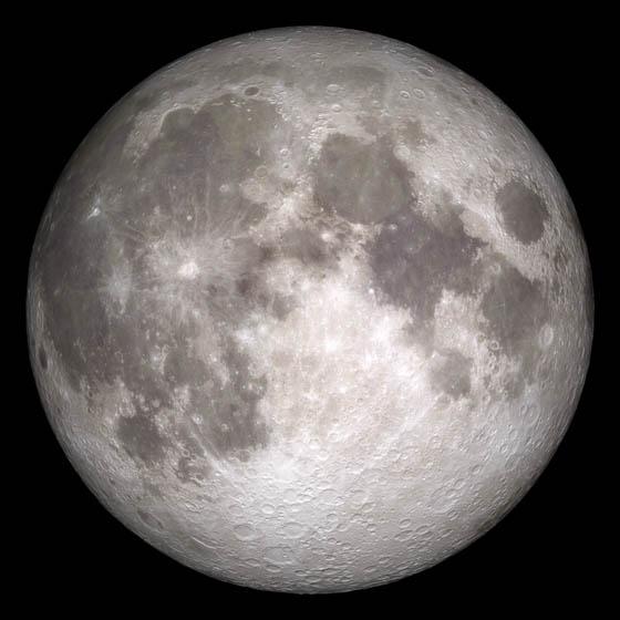
Current moon as viewed on Wednesday, June 15, 2011, 19:00 UT (Phase 100%)  This marks the first time that accurate shadows at this level of detail are possible in such a computer simulation. The shadows are based on the global elevation map…
Current Moon - June 15, 2011
STS054-95-042 (13-19 Jan 1993) --- The Equatorial Pacific Ocean is represented in this 70mm view.  The international oceanographic research community is presently conducting a program called Joint Global Ocean Flux Study (JGOFS) to study th…
Equatorial Wave Line, Pacific Ocean
STS040-614-047 (5-14 June 1991) ---  This image is of the Norfolk, Virginia -- Southern Delmarva Peninsula Southern Chesapeake Bay Area as seen in sunlight.  The exposure is adjusted to emphasize the water patterns present.  The outgoing ti…
Water Surface Turbulance and Internal Waves, Norfolk, VA, USA
This spectacular north looking view of south Greenland (62.0N, 46.0W) shows numerous indentations along the coastline, many of which contain small settlements. These indentations are fiords carved by glaciers of the last ice age. Even today…
South Greenland, North Atlantic Ocean
Engineers Raquel Rodriguez Monje and Fabien Nicaise discuss placement of the DopplerScatt radar instrument on the NASA B200 before its final installation onto the aircraft’s fuselage.
NASA Engineers Install DopplerScatt Instrument
Army Lt. Gen. James Dickinson, right, commanding general of the U.S. Army Space and Missile Defense Command, speaks with NASA astronaut and current International Space Station crew member Andrew Morgan, an Army colonel, during an Oct. 8 dow…
Army Lt. Gen. James Dickinson, right, commanding general of the
Edgar Reyes, a materials engineer and recent graduate of The University of Texas at El Paso, visually inspects a crack identified on the outer surface of a composite overwrapped pressure vessel (COPV) following an internal eddy-current thro…
Nondestructive Inspection
Engineers (from left) Ayrton Jordan, Anthony Milana and Edgar Reyes from the NASA White Sands Test Facility (WSTF) in Las Cruces, N.M. qualify an interior surface pressure vessel crack inspection using the eddy current nondestructive testin…
Nondestructive Inspection
SL4-137-3632 (February 1974) --- A photograph taken from the Skylab space station in Earth orbit illustrating an atmospheric wave pattern by the affect of a small mountainous island on wind currents. Various patterns can be seen downwind of…
View of atmospheric wave patterns by effect of island on wind currents
The northeast coast of Hokkaido and Kunashir Island, Japan (44.0N, 143.0E) are seen bordered by drifting sea ice. The sea ice has formed a complex pattern of eddies in response to surface water currents and winds. Photos of this kind aid re…
Northeast Coast, Hokkaido, Japan
STS007-05-245 (18-24 June 1983) --- A rare view of internal waves in the South China Sea.  Several different series of internal waves are represented in the 70mm frame,  exposed with a handheld camera by members of the STS-7 astronaut crew…
Internal Waves, South China Sea
NASA’s B200 taking off for an eight-hour science flight on March 5. Located on the center of the aircraft’s fuselage is the DopplerScatt radar instrument, developed by NASA’s Jet Propulsion Laboratory in California.
DopplerScatt B200 Takeoff
STS046-80-009 (31 July-8 Aug. 1992) --- A view of the mouth of the Amazon River and the Amazon Delta shows a large sediment plume expanding outward into the Atlantic Ocean. The sediment plume can be seen hugging the coast north of the Delta…
Mouths of the Amazon River, Brazil, South America
Engineers Ayrton Jordan (left) and Anthony Milana (right) at the NASA White Sands Test Facility (WSTF) in Las Cruces, N.M. install a metallic liner into the multipurpose pressure vessel scanner that could one day become part of a composite…
Nondestructive Inspection
SL4-137-3655 (16 Dec. 1973) --- An island wake produced by the Antipodes Islands in the ocean current south of New Zealand is seen in this photograph taken from the Skylab space station in Earth orbit. A Skylab 4 crewmen took the picture wi…
Island wake produced by Antipodes Islands south of New Zealand
STS044-79-077 (24 Nov.-1 Dec. 1991) --- This photograph, captured from the Earth-orbiting Space Shuttle Atlantis, shows sunglint pattern in the western tropical Indian Ocean. Several large internal waves reflect around a shallow area on the…
Internal Waves, Western Indian Ocean
This large tabular iceberg, broken off from the Antarctic Ice Sheet, was spotted in the South Atlantic Ocean (57.0S, 57.0W) southeast of the tip of South America as it was slowly being moved north and east by wind, current and tidal influen…
Large Tabular Iceberg, South Atlantic Ocean
Radar operator Alexander Winteer monitors incoming wind data from the  DopplerScatt radar instrument during a science flight off the California Coast on March 5, 2018.
Instrument Operator Monitors Wind Data
STS054-72-056 (13-19 Jan 1993) --- A ship wake in the Bay of Bengal is noticeable in this 70mm frame.  The sun glint pattern on the ocean reveals many patterns of sea surface roughness related to currents, waves, wind roughening, and biolog…
STS-54 Earth observation of a ship wake in the Bay of Bengal
No more images