Acquisition Date: February 28, 1985  The Sierra de Velasco Mountains dominate this image in northern Argentina. The Catamarca province is in the northern part of the image, and the La Rioja province is to the south. The streams are fed by r…
Argentina
Image acquired December 19, 2011  A strong low pressure area in the southwestern U.S. today is bringing snowfall there as NOAA's GOES-13 satellite captured its associated clouds. Blizzard warnings are already posted for some areas.  The ima…
GOES Satellite Sees Strong Front Bringing Blizzard Conditions to U.S. Southwest
SL3-33-167 (July-September 1973) --- A vertical view of the Argentina-Paraguay border area of South America as photographed from Earth orbit by one of the six lenses of the Itek-furnished S190-A Multispectral Photographic Facility Experimen…
View of Argentina-Paraguay border area of South America
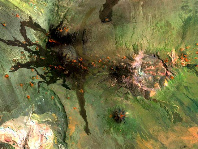
Situated in the southern Andes Mountains, the Payún volcanic field of Argentina is a complex landscape that formed over hundreds of thousands of years. Sprawling over 5,200 square kilometers (2,000 square miles), Payún is a massive shield v…
Payún Volcanic Field
AS07-04-1593 (21 Oct. 1968) --- This Earth observation photograph shows Argentina, Chile, Bolivia, Salar de Atacama, the Andes Mountains, and Gran Chaco. The coordinates for the center of this photograph are 23.00 degrees south and 67.30 de…
Northwestern Argentina as seen from the Apollo 7 spacecraft
June 13, 2011  The MODIS instrument on NASA's Terra satellite captured this visible image of the ash plume from the eruption of the Puyehue-Cordón Caulle volcano, Chile on June 13 at 14:35 UTC (10:35 a.m. EDT). The wind shifted from the day…
Volcano Plume Continues Blowing East Over Argentina to Atlantic Ocean
Hubble Space Telescope (HST), with its solar array (SA) wings and high gain antennae (HGA) fully extended,is released from Discovery's, Orbiter Vehicle (OV) 103's, remote manipulator system (RMS) end effector and is set free into Earth orbi…
STS-31 Hubble Space Telescope (HST) drifts away from OV-103's RMS
STS054-151-150 (13-19 Jan 1993) --- View west into sun glint off the Rio Salado, Saladillo, and Parana Rivers in Argentina.  The Space Shuttle nadir is about 28 degrees north latitude and 57 degrees west longitude.  The Andes Mountains are…
Thunderstorms, Andean Mountains Ridgeline, Argentina
AST-27-2341 (20 July 1975) --- A near vertical view of sand dunes in the San Juan Province of Western Argentina, as photographed from the Apollo spacecraft in Earth orbit during the joint U.S.-USSR Apollo-Soyuz Test Project mission. The pic…
View of sand dunes in the San Juan Province of Western Argentina
SL4-137-3632 (February 1974) --- A photograph taken from the Skylab space station in Earth orbit illustrating an atmospheric wave pattern by the affect of a small mountainous island on wind currents. Various patterns can be seen downwind of…
View of atmospheric wave patterns by effect of island on wind currents
iss058e002245 (Jan. 7, 2019) --- The U.S. Cygnus space freighter from Northrop Grumman and its prominent cymbal-shaped UltraFlex solar arrays are pictured as the International Space Station orbited 262 miles above the Atlantic Ocean off the…
The U.S. Cygnus space freighter from Northrop Grumman
No more images