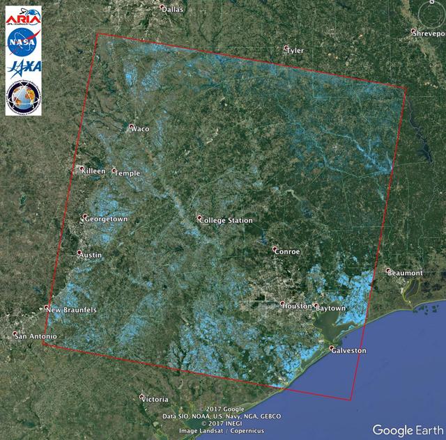
The Advanced Rapid Imaging and Analysis (ARIA) team at NASA's Jet Propulsion Laboratory in Pasadena, California, created this Flood Proxy Map depicting areas of Southeastern Texas that are likely flooded as a result of Hurricane Harvey, sho…
Scientists with the Advanced Rapid Imaging and Analysis project (ARIA), a collaboration between NASA's Jet Propulsion Laboratory in Pasadena, California, and Caltech, also in Pasadena, used synthetic aperture radar (SAR) data from the Europ…
The Advanced Rapid Imaging and Analysis (ARIA) team at NASA's Jet Propulsion Laboratory in Pasadena, California, created this map depicting areas that are likely damaged as a result of the recent major earthquakes in Southern California. Th…
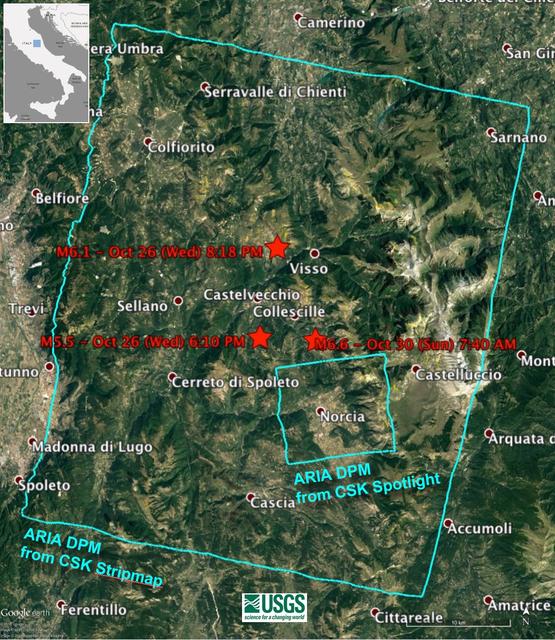
A NASA-funded program provided valuable information for responders and groups supporting the recovery efforts for the Aug. 24, 2016, magnitude 6.2 earthquake that struck central Italy. The earthquake caused significant loss of life and prop…
The Advanced Rapid Imaging and Analysis (ARIA) team at NASA's Jet Propulsion Laboratory in Pasadena, California, and Caltech, also in Pasadena, created a Damage Proxy Map (DPM) depicting areas in Southern California that are likely damaged…
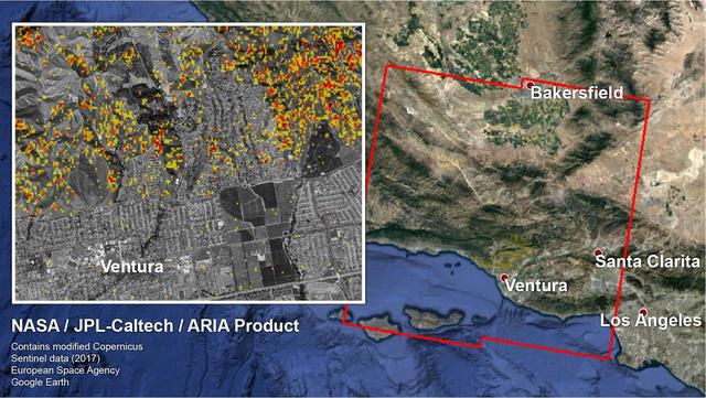
The Advanced Rapid Imaging and Analysis (ARIA) team at NASA's Jet Propulsion Laboratory in Pasadena, California, created these Damage Proxy Maps (DPMs) depicting areas in California likely damaged by the Woolsey and Camp Fires. They are der…
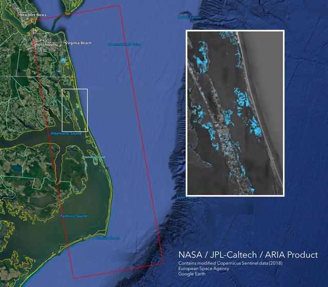
The Advanced Rapid Imaging and Analysis (ARIA) team at NASA's Jet Propulsion Laboratory in Pasadena, California, created this Flood Proxy Map depicting areas of the Carolinas that are likely flooded as a result of Hurricane Florence, shown…
NASA scientists are using satellite data to assess the damage on Florida's Gulf Coast after Hurricane Ian, which made landfall in the state as a Category 4 storm on Sept. 28, 2022. The Advanced Rapid Imaging and Analysis (ARIA) team at NAS…
The Advanced Rapid Imaging and Analysis (ARIA) team at NASA's Jet Propulsion Laboratory in Pasadena, California, in collaboration with the Earth Observatory of Singapore (EOS), created this flood map depicting areas of the Bahamas that are…
The Advanced Rapid Imaging and Analysis (ARIA) team at NASA's Jet Propulsion Laboratory in Pasadena, California, created these flood proxy maps depicting areas of Mozambique that are likely flooded as a result of Cyclone Idai. The likely fl…
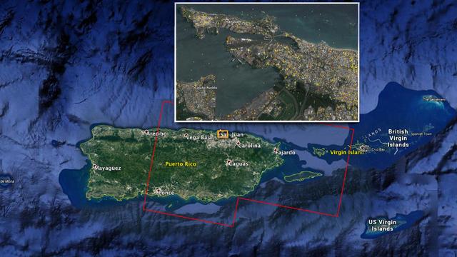
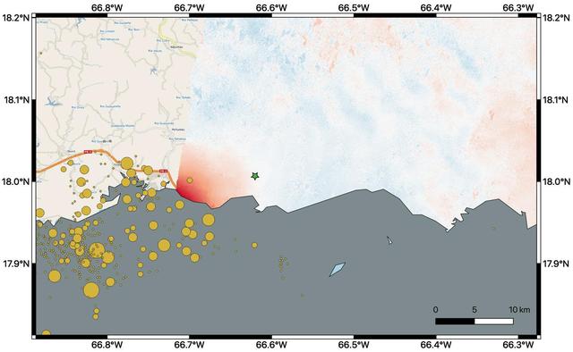
NASA scientists are helping local and federal agencies assess the extent of the damage in Puerto Rico following a 6.4-magnitude earthquake and hundreds of aftershocks. Using synthetic aperture radar data from the Copernicus Sentinel-1 satel…
The Advanced Rapid Imaging and Analysis (ARIA) team at NASA's Jet Propulsion Laboratory in Pasadena, California, and Caltech, also in Pasadena, created this Damage Proxy Map (DPM) depicting areas of Southern Mexico that are likely damaged (…
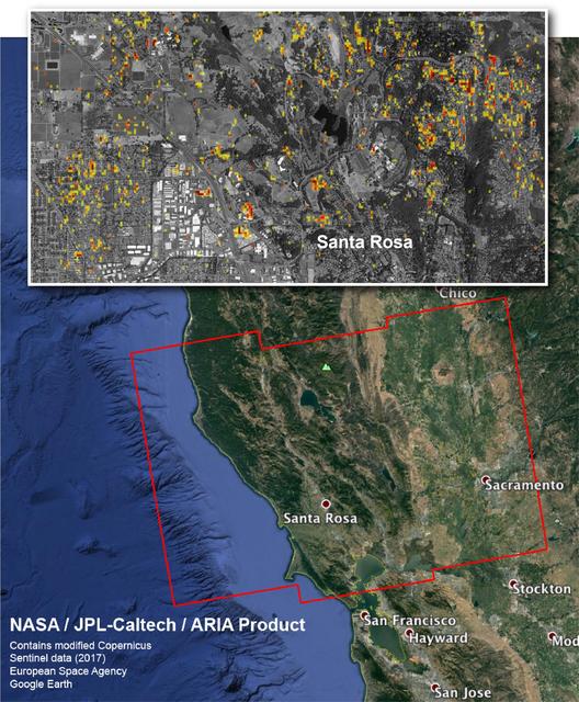
The Advanced Rapid Imaging and Analysis (ARIA) team at NASA's Jet Propulsion Laboratory in Pasadena, California, and Caltech, also in Pasadena, created this Damage Proxy Map depicting areas in Northern California that are likely damaged (sh…
On Nov. 27, 2022, Mauna Loa, Earth's largest active volcano, began erupting from the summit caldera inside Hawaii Volcanoes National Park. Scientists with the Advanced Rapid Imaging and Analysis project (ARIA), a collaboration between NASA…
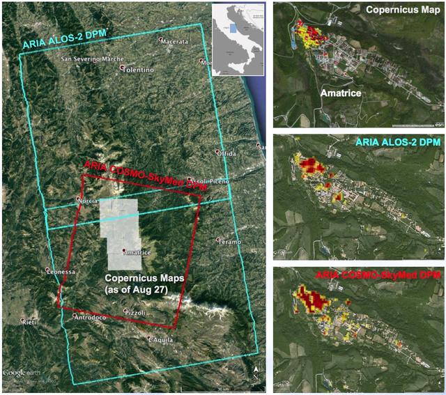
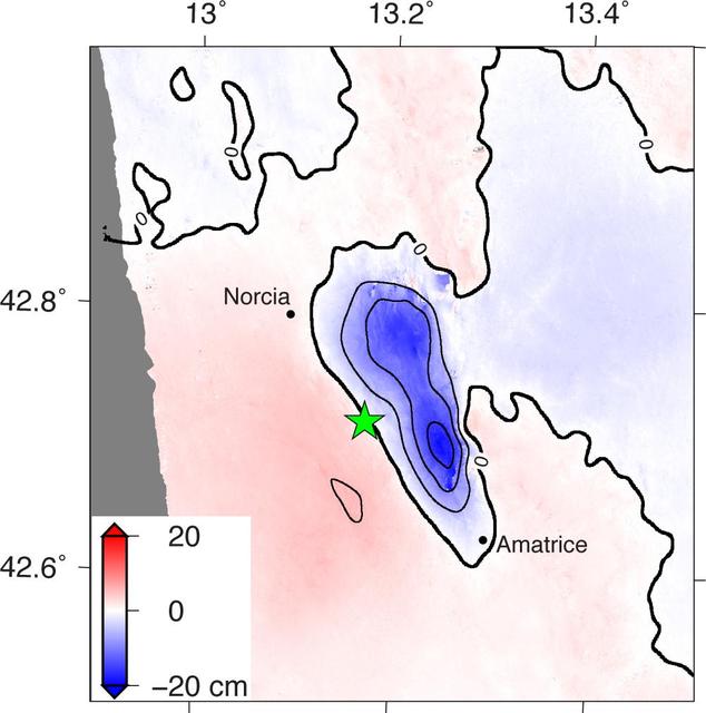
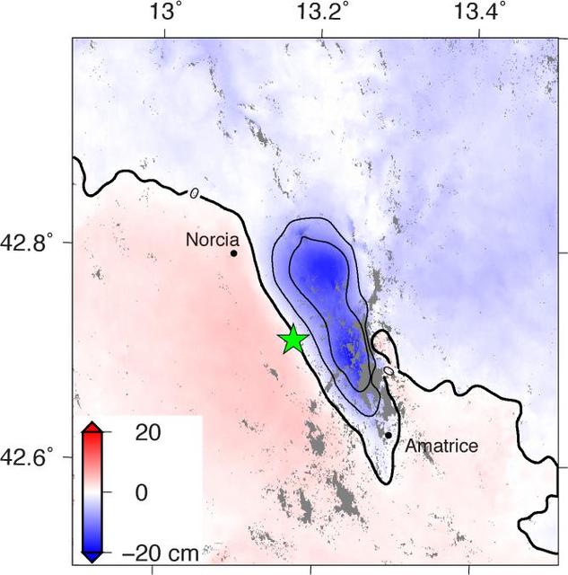
NASA and its partners are contributing observations and expertise to the ongoing response to the Aug. 23, 2016, magnitude 6.2 Amatrice earthquake in central Italy caused widespread building damage to several towns throughout the region. Thi…
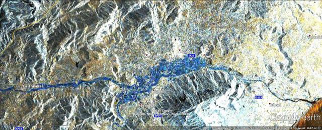
In mid-November 2013, extratropical cyclone Cleopatra brought devastating flooding to the Italian island of Sardinia as shown by the COSMO-SkyMed satellite.
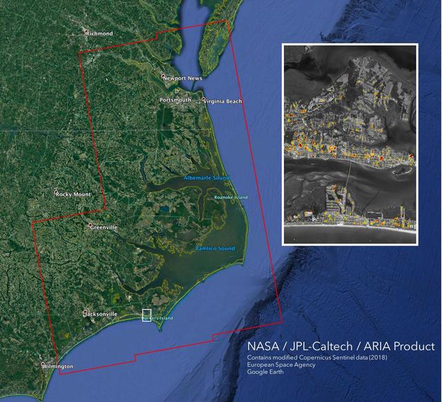
The Advanced Rapid Imaging and Analysis (ARIA) team at NASA's Jet Propulsion Laboratory in Pasadena, California, created this Damage Proxy Map (DPM) depicting areas of the Carolinas that are likely damaged (shown by red and yellow pixels) a…
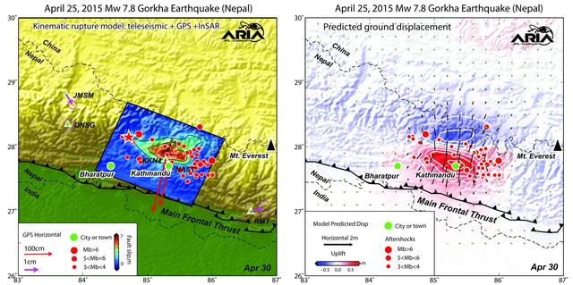
Using a combination of GPS-measured ground motion data, satellite radar data, and seismic observations from instruments distributed around the world, scientists have constructed preliminary estimates of how much the fault responsible for th…
NASA and its partners are contributing important observations and expertise to the ongoing response to the Sept. 7, 2017 (local time), magnitude 8.1 Oaxaca-Chiapas earthquake in Mexico. This earthquake was the strongest in more than a centu…
NASA's ARIA team, in collaboration with the Earth Observatory of Singapore, used satellite data to map the extent of likely damage following a massive explosion in Beirut. Dark red pixels represent the most severe damage. Areas in orange ar…
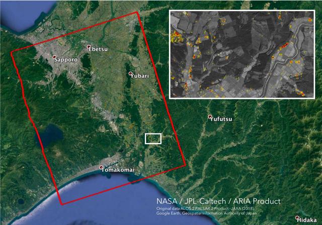
The Advanced Rapid Imaging and Analysis (ARIA) team at NASA's Jet Propulsion Laboratory in Pasadena, California, and Caltech, also in Pasadena, created this Damage Proxy Map (DPM) depicting areas in the southwestern part of Hokkaido, Japan,…
The Advanced Rapid Imaging and Analysis (ARIA) team at NASA's Jet Propulsion Laboratory in Pasadena, California, and Caltech, also in Pasadena, created this Damage Proxy Map (DPM) depicting areas in Central Sulawesi, Indonesia, including th…
Amatrice earthquake in central Italy, which caused widespread building damage to several towns throughout the region. This earthquake was the strongest in that area since the 2009 earthquake that destroyed the city of L'Aquila. The Advance…
The rate of neutron flow is commonly referred to as a flux. The measurement of neutron fluxes in Skylab was the subject of a proposal by Terry Quist of San Antonio, Texas. This chart describes Quist's experiment, Neutron Analysis, Skylab st…
Damage Proxy Map (DPM) v0.5, derived from the Italian Space Agency's COSMO-SkyMed Spotlight synthetic aperture radar (SAR) data acquired from an ascending orbit, covering an area of 6.2-by-6.2 miles (10-by-10 kilometers), centered at Norcia…
The Advanced Rapid Imaging and Analysis (ARIA) team at NASA's Jet Propulsion Laboratory in Pasadena, California, and Caltech, also in Pasadena, created this Damage Proxy Map (DPM) depicting areas of Eastern Puerto Rico that are likely damag…
The Marshall Space Flight Center (MSFC) and the Johnson Space Center (JSC) were each awarded 16-month contracts in April 1976 for the Space Station Systems Analysis Study (SSSAS). Grumman Aerospace Corporation was MSFC's contractor and McDo…
ProVision Technologies, a NASA research partnership center at Sternis Space Center in Mississippi, has developed a new hyperspectral imaging (HSI) system that is much smaller than the original large units used aboard remote sensing aircraft…
A magnitude 6.0 earthquake struck southern Napa county northeast of San Francisco, California, on Aug. 24, 2014. NASA satellite data reveal ground defomation.
Typhoon Hagibis, one of the most destructive storms to hit Japan in decades, made landfall on Saturday, Oct. 12, 2019 southwest of Tokyo with wind speeds equivalent to a Category 3 hurricane. The damage it left in its wake is visible from s…
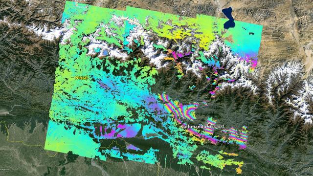
This false-color map from NASA ARIA project shows the amount of permanent surface movement caused almost entirely by the magnitude 7.8 Gorkha earthquake in Nepal.
The Advanced Rapid Imaging and Analysis (ARIA) team at NASA's Jet Propulsion Laboratory in Pasadena, California, created this Damage Proxy Map (DPM) depicting areas of Northern California that are likely damaged (shown by red and yellow pix…
On August 14, 2021, a magnitude 7.2 earthquake struck western Haiti causing widespread damage and loss of life, and triggering landslides throughout the region. Scientists with the Advanced Rapid Imaging and Analysis project (ARIA), a coll…
This satellite interferometric synthetic aperture radar image using COSMO-SkyMed radar data, depicts the relative deformation of Earth surface at Kilauea between Feb. 11, 2011 and March 7, 2011 two days following the start of the current er…
NASA and its partners are contributing important observations and expertise to the ongoing response to the Nov. 14, 2016, magnitude 7.8 Kaikoura earthquake in New Zealand. This shallow earthquake was so complex and unusual, it is likely to…
By comparing interferometric synthetic aperture radar (InSAR) data acquired on Jan. 9, 2020, with data acquired on Dec. 28, 2019, from the Copernicus Sentinel-1A satellite, NASA scientists were able to map where, how much and in what direct…
NASA and its partners are contributing important observations and expertise to the ongoing response to the April 25, 2015, magnitude 7.8 Gorkha earthquake in Nepal. The quake was the strongest to occur in that area since the 1934 Nepal-Biha…
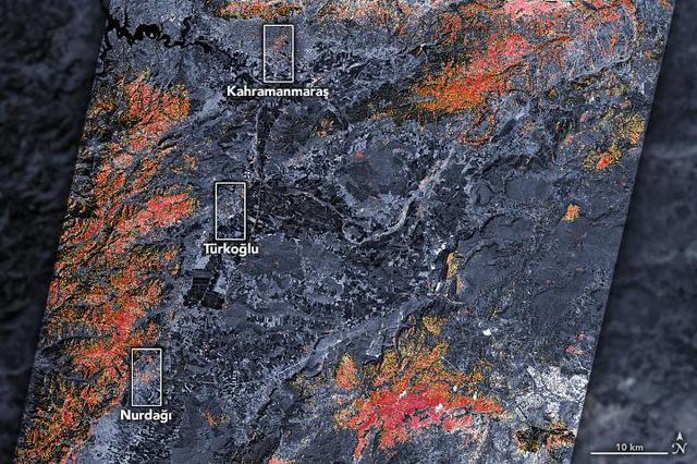
The magnitude 7.8 and 7.5 earthquakes that struck southern Turkey and western Syria on February 6, 2023, caused widespread destruction in both countries. The initial, stronger earthquake emanated from a fault 11 miles (18 kilometers) below…
The Advanced Rapid Imaging and Analysis (ARIA) team at NASA's Jet Propulsion Laboratory in Pasadena, California, and Caltech, also in Pasadena, created this Damage Proxy Map (DPM) depicting areas in the northeastern part of Lombok Island, I…
The Advanced Rapid Imaging and Analysis (ARIA) team at NASA's Jet Propulsion Laboratory in Pasadena, California, and Caltech, also in Pasadena, created this Damage Proxy Map (DPM) depicting areas of Central Mexico, including Mexico City, th…
The Advanced Rapid Imaging and Analysis (ARIA) team at NASA's Jet Propulsion Laboratory in Pasadena, California, created this map of the Ridgecrest area of Southern California following two strong earthquakes — a magnitude 6.4 on July 4 and…
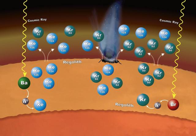
Chemistry that takes place in the surface material on Mars can explain why particular xenon (Xe) and krypton (Kr) isotopes are more abundant in the Martian atmosphere than expected. The isotopes -- variants that have different numbers of n…
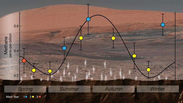
NASA's Curiosity rover used an instrument called SAM (Sample Analysis at Mars) to detect seasonal changes in atmospheric methane in Gale Crater. The methane signal has been observed for nearly three Martian years (nearly six Earth years), p…
STS075-360-021 (22 Feb.- 9 March 1996) --- The loose tether forms a faint diagonal line in this scene recorded on a later fly-by. On Feb. 25, 1996, the crew deployed the Tethered Satellite System (TSS), which later broke free. The seven m…