NASA image acquired Feb. 9, 2011  Less than 5 percent of Algeria’s land surface is suitable for growing crops, and most precipitation falls on the Atlas Mountains along the coast. Inland, dust-laden winds blow over rocky plains and sand sea…
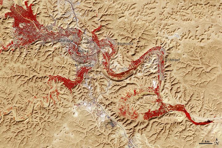
M’zab Valley, Algeria
S66-45749 (18 July 1966) --- Straits of Gibraltar, Mediterranean Sea, Spain in background, Algeria and Morocco in foreground as seen from Gemini-10 spacecraft. Photo credit: NASA
Straits of Gibralter, Mediterranean Sea, Spain as seen from Gemini 10
S65-63830 (5 Dec. 1965) --- Algeria, south-southeast of the Colomb Bechar area, as seen from the National Aeronautics and Space Administration's Gemini-7 spacecraft. Sand dunes are 200 to 300 feet high in the Grand Erg Occidental area. The…
Algeria- Gemini 7, Earth-Sky View
The 16th American assembly flight and 112th overall American flight to the International Space Station (ISS), launched on November 23, 2002 from Kennedy's launch pad 39A aboard the Space Shuttle Orbiter Endeavor STS-113. Mission objectives…
International Space Station (ISS)
STS049-92-071 (13 May 1992) --- The STS-49 crew aboard the Earth-orbiting Space Shuttle Endeavour captured this Saharan dust storm on the Algeria-Niger border.  The south-looking, late-afternoon view shows one of the best examples in the Sh…
Dust Storm, Sahara Desert, Algeria/Niger Border, Africa
No more images