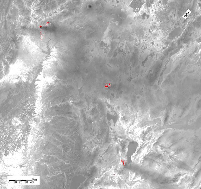
The Thomas Fire is the largest wildfire in California's recorded history. As of January 3, 2018, it was 93 percent contained after burning 282,000 acres and destroying 1,063 structures. The fire started Dec. 4, 2017, and quickly spread out…
Devastation from California's Largest Wildfire Seen in New NASA Satellite Image
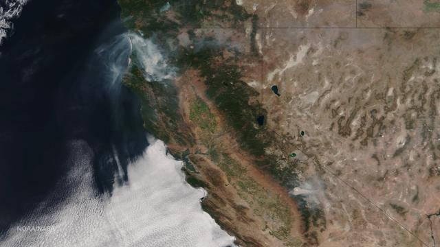
Very hot, dry and unstable conditions in California and across the Pacific Northwest add to the challenges facing firefighters as they battle blazes around the region. Cal Fire is urging Californians to be extremely cautious, especially for…
Wildfires in California, August 17, 2015
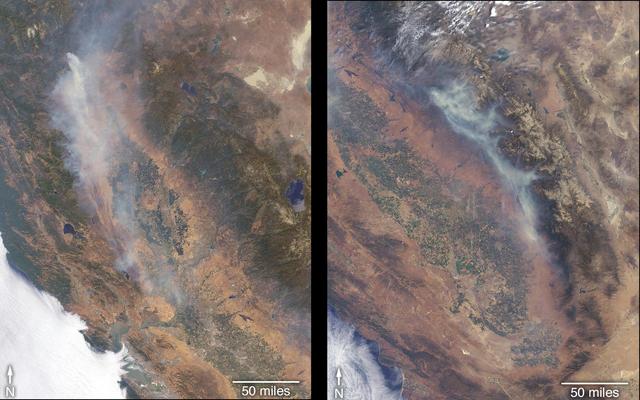
The Multi-angle Imaging SpectroRadiometer (MISR) instrument on NASA's Terra satellite took these images of the Carr Fire (left) and the Ferguson Fire (right) on July 27 and July 29, respectively.  The Carr Fire, which has been burning near…
California Wildfires Captured by NASA Satellite
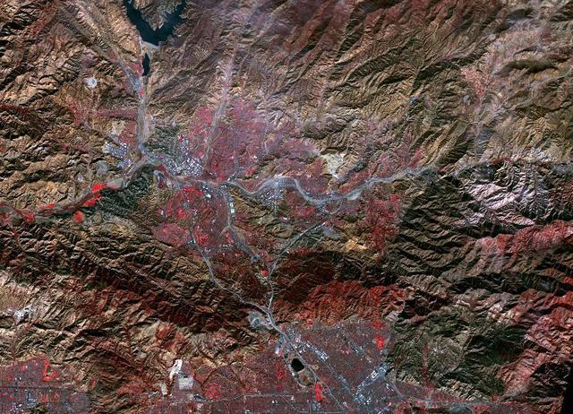
In San Bernardino County, California, the Blue Cut fire burned ferociously for one week starting Aug. 16, 2016. By the time it was contained, it had burned 36,000 acres and destroyed 105 homes. More than 80,000 people were affected by evacu…
Extent of California Blue Cut Fire Devastation Seen by NASA Spacecraft
While the Thomas fire in Ventura County, CA is the largest and most destructive, several other smaller fires burned in the Los Angeles area. The Creek fire destroyed 123 buildings and consumed over 15,000 acres. The smaller Rye fire burned…
Creek and Rye Fires, Southern California
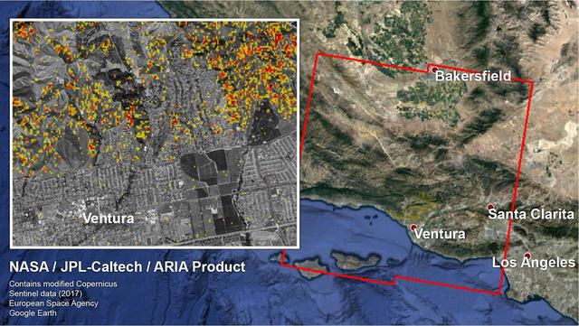
The Erskine wildfire, northeast of Bakersfield, California, is the state's largest to date in 2016. After starting on June 23, the fire has consumed 47,000 acres (19,020 hectares), destroyed more than 250 single residences, and is responsib…
Impact of Destructive California Wildfire Captured by NASA Spacecraft
On July 24, 2022, the Multi-angle Imaging SpectroRadiometer (MISR) instrument aboard NASA's Terra satellite captured data on a smoke plume from the Oak Fire burning near Yosemite National Park in California. As of July 26, the Oak Fire had…
MISR Images Oak Fire Near Yosemite
The Soberanes fire, in Central California near Big Sur, had grown to more than 67,000 acres when the Advanced Spaceborne Thermal Emission and Reflection Radiometer (ASTER) instrument on NASA's Terra spacecraft captured this image on Aug. 6,…
Growing Wildfire Near Big Sur, California Imaged by NASA Terra Spacecraft
39,000 acres (60 square miles, or 160 square kilometers). Thousands of residents were evacuated, and the fire claimed the life of one person. The Multi-angle Imaging SpectroRadiometer (MISR) instrument aboard NASA's Terra satellite passed o…
NASA MISR Studies Smoke Plumes from California Sand Fire
The Multi-angle Imaging SpectroRadiometer (MISR) instrument on NASA's Terra satellite took this image of the Woolsey Fire in southern California on Nov. 11, 2018. The Woolsey Fire had charred more than 90,000 acres as of Nov. 12, 2018, and…
NASA's MISR Sees California's Woolsey Fire From Space
The blue dots in this field of galaxies, known as the COSMOS field, show galaxies that contain supermassive black holes emitting high-energy X-rays. The black holes were detected by NASA's Nuclear Spectroscopic Array, or NuSTAR, which spott…
Wyoming Wildfire Spotted by NASA Spacecraft
As firefighters continue to work toward full containment of the rash of wildfires burning in Northern California, a new image from the Advanced Spaceborne Thermal Emission and Reflection Radiometer (ASTER) instrument on NASA's Terra satelli…
Impact of Northern California Fires Seen in New NASA Satellite Image
The Advanced Rapid Imaging and Analysis (ARIA) team at NASA's Jet Propulsion Laboratory in Pasadena, California, and Caltech, also in Pasadena, created a Damage Proxy Map (DPM) depicting areas in Southern California that are likely damaged…
NASA-Produced Map Shows Extent of Southern California Wildfire Damage
NASA's Airborne Visible Infrared Imaging Spectrometer instrument (AVIRIS), flying aboard a NASA Armstrong Flight Research Center high-altitude ER-2 aircraft, observed wildfires burning in Southern California on Dec. 5-7, 2017. AVIRIS is an…
Multiple Aspects of the Southern California Wildfires as Seen by NASA's AVIRIS
NASA's ECOsystem Spaceborne Thermal Radiometer Experiment on Space Station (ECOSTRESS) has imaged a temperature profile of an area surrounding a fire-induced tornado in Loyalton, California. A 20,000-acre wildfire early on Saturday, Aug. 15…
NASA's ECOSTRESS Sees Fire-Induced Tornado From Space
Late in the evening on September 27, 2020 the Glass Fire ignited in the foothills of Napa Valley, California. The cause of the fire is still unknown. Within 24 hours it exploded to over 11,000 acres fueled by dehydrated soil and the drought…
Glass Fire, September 27, 2020
NASA flew an aircraft equipped with Uninhabited Aerial Vehicle Synthetic Aperture Radar (UAVSAR) flew above California fires on Sept. 3 and 10. The smoke-penetrating UAVSAR enables scientists to get a close-up view of how these fires have a…
NASA's UAVSAR Flights Observe California Fires
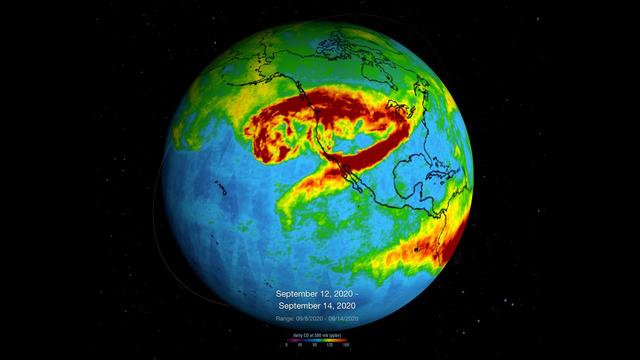
NASA's Atmospheric Infrared Sounder (AIRS), which is aboard the Aqua satellite, captured carbon monoxide plumes coming from California wildfires last week. There were 28 major wildfires burning across the state as of Sept. 14. This includes…
NASA's AIRS Instrument Monitors Carbon Monoxide From California Wildfires
Data from the Multi-angle Imaging SpectroRadiometer (MISR) instrument aboard NASA's Terra satellite was used to produce this stereo anaglyph of the Woolsey Fire in southern California on Nov. 11, 2018. It shows a three-dimensional view of t…
NASA's MISR Captures 3D Image of Smoke from California's Woolsey Fire
The Thomas fire, west of Los Angeles, continues to advance to the west and north and is threatening a number of coastal communities, including Santa Barbara. It is now the fifth largest wildfire in modern California history. According to CA…
Destructive Thomas Fire Continues Its Advance in New NASA Satellite Image
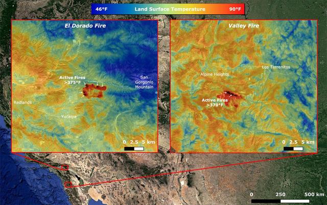
On Sept. 6, NASA's ECOsystem Spaceborne Thermal Radiometer Experiment on Space Station (ECOSTRESS) imaged active fires across California, including the El Dorado fire near Yucaipa and the Valley fire in Japatul Valley in the southern part o…
NASA's ECOSTRESS Takes Surface Temperature Around California Fires
NASA's Advanced Spaceborne Thermal Emission and Reflection Radiometer (ASTER) instrument imaged areas burned by the Bighorn Fire north of Tucson, Arizona, on June 29. In the image, vegetation is shown in red and burned areas are shown in da…
Arizona Bighorn Fire 2020
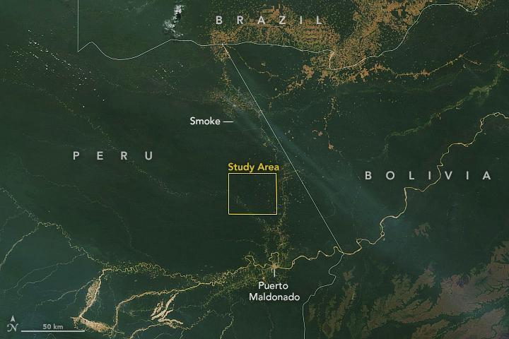
This satellite image, taken by NASA's Earth-observing Terra satellite on Aug. 18, 2019, shows the ECOSTRESS study area in the Amazon Basin and smoke from active fires in the rainforest. ECOSTRESS also captured an image of the Amazon rainfor…
NASA Terra Satellite Sees Amazon Fires in Peru
Thousands of acres damaged by the ongoing Kincade Fire in Northern California's Sonoma County are visible in this new image from the Advanced Spaceborne Thermal Emission and Reflection Radiometer (ASTER) instrument aboard NASA's Terra satel…
ASTER Sees Kincade Fire Damage From Space
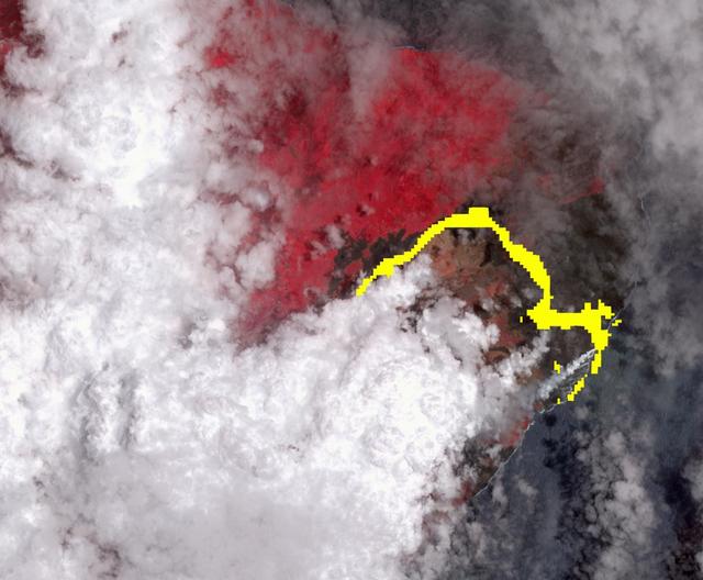
Hawaii's Kilauea volcano continues to create new land as flows from fissure 8, one of the most active to break ground since the eruption began in early May, reach the ocean. The Advanced Spaceborne Thermal Emission and Reflection (ASTER) ra…
NASA Satellite Imagery Shows Hawaii Volcano Lava Flow
On August 18, 2021, at 12:10 p.m. local time, the Multi-angle Imaging Spectroradiometer (MISR) instrument captured imagery of the McCash, Antelope, River Complex, Monument, and Dixie fires as it passed overhead aboard NASA's Terra satellite…
NASA's MISR Instrument Detects Smoke Plumes Over Northern California
On Aug. 26, 2020, Advanced Spaceborne Thermal Emission and Reflection Radiometer (ASTER) instrument aboard NASA's Terra satellite passed over the River and Carmel fires in Monterey County, California, got a bird's eye view of the vast fire…
ASTER Gets a Birdseye View of the Carmel and River Fire Burn Areas
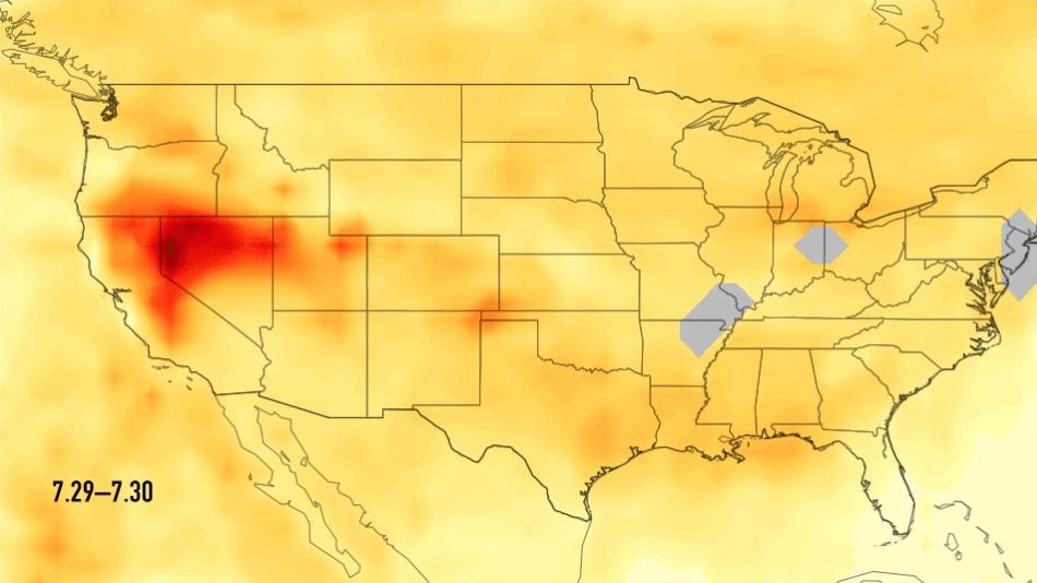
This single frame from a series of images shows carbon monoxide (in orange/red) from California's massive wildfires drifting east across the U.S. between July 30 and August 7, 2018. It was produced using data from the Atmospheric Infrared S…
Carbon Monoxide Transport from California Wildfires, July 30-August 7, 2018
The Advanced Rapid Imaging and Analysis (ARIA) team at NASA's Jet Propulsion Laboratory in Pasadena, California, created this Damage Proxy Map (DPM) depicting areas of Northern California that are likely damaged (shown by red and yellow pix…
Updated ARIA Map of CA Camp Fire Damage
NASA's Aqua satellite captured this image of the clouds over Canada.  Entwined within the clouds is the smoke billowing up from the wildfires that are currently burning across a large expanse of the country.  The smoke has become entrained…
Smoke From Canadian Wildfires Trapped in Clouds
Widespread agricultural burning continues throughout central Africa. Smoke and fires in several countries were seen by the Suomi NPP satellite. Most of the fires were burning in the southern region of the Democratic Republic of the Congo, T…
Fires in Central Africa
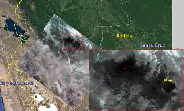
NASA's Ecosystem Spaceborne Thermal Radiometer Experiment on Space Station (ECOSTRESS) captured new imagery of fires in the Amazon regions of Brazil and Bolivia on Aug. 23, 2019. The red areas are where surface temperatures exceeded the max…
Amazon Fires Seen by NASA's ECOSTRESS
Throughout the month of September 2020, NASA's ECOsystem Spaceborne Thermal Radiometer Experiment on Space Station (ECOSTRESS) imaged multiple wildfires across the state of California.  The image above shows the ECOSTRESS land surface tempe…
NASA's ECOSTRESS Images California Wildfires From Space
Extreme winter rains in January 2018 following the Thomas Fire in Ventura and Santa Barbara Counties caused severe debris flows, resulting in significant loss of life and considerable property damage in the town on Montecito, just east of S…
Effects of Deadly California Debris Flows Seen in Before/After Images from NASA's UAVSAR
NASA Terra satellite passed directly over the island of Madeira on Wednesday, Aug. 10, 2016, where a wildfire spread to the capital city of Funchal.
Deadly Fires Engulfing Madeira seen by NASA MISR
Fires began near the Chernobyl Nuclear Power Plant in Ukraine April 4, 2020. By April 14, the fires were nearly extinguished. On April 16, new fires erupted, sending large, dark gray clouds of smoke traveling over 750 km to the southeast. T…
Ukraine Fires, Russia
The 416 Fire started June 1, 2018, about 13 miles (18 kilometers) north of Durango, Colorado. Four weeks later, the fire was mostly contained, after consuming 35,000 acres of timber and brush. The cause of the fire is presently unknown. Thi…
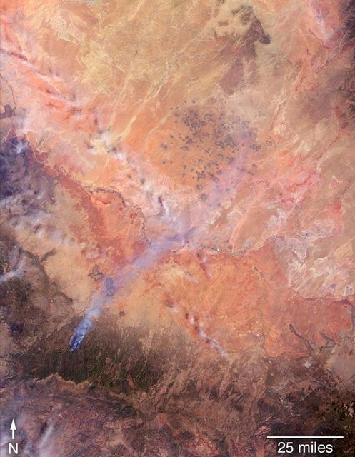
Colorado Wildfire Imaged in Infrared by NASA Satellite
A wildfire spread to the capital city of Funchal on the island of Madeira, an autonomous region of Portugal, over the nighttime hours of Tuesday, Aug. 9, 2016, with three deaths reported and hundreds of others hospitalized. Several homes an…
Deadly Fires Engulfing Madeira seen by NASA MISR
On April 27, 2018, the Tinder Fire ignited in eastern Arizona near the Blue Ridge Reservoir, about 50 miles (80 kilometers) southeast of Flagstaff and 20 miles (32 kilometers) northeast of Payson. During the first 24 hours it remained relat…
Tinder Fire in Arizona Viewed by NASA's MISR
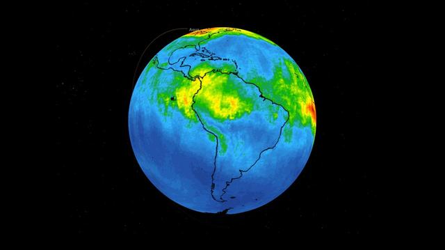
This time series shows carbon monoxide associated with fires from the Amazon region in Brazil from Aug. 8-22, 2019. The images show carbon monoxide at an hPA — a common unit of measurement for atmospheric pressure — of 500, or approximately…
NASA's AIRS Maps Carbon Monoxide from Brazil Fires
The Sand fire, in the mountains northwest of Los Angeles, has burned more than 39,000 acres, destroyed 18 houses, and caused one fatality. By August 1, 2016, when the Advanced Spaceborne Thermal Emission and Reflection Radiometer (ASTER) in…
NASA Spacecraft Spots Aftermath of Destructive Wildfire in LA Backyard
On Aug. 16, 2016, at around 10:30 a.m., a brush fire ignited in the Cajon Pass east of Los Angeles, just to the west of Interstate 15. Within a matter of hours, extreme temperatures, high winds and low humidity allowed the fire to spread ra…
Long Smoke Plumes from California Destructive Bluecut Fire Spotted by NASA MISR
Canada has already had its share of wildfires this season, and the smoke from these wildfires is slowly drifting south over the United States' Midwest.  The drifting smoke can be seen in this Terra satellite image over Lake Michigan, as wel…
Smoke From Canadian Wildfires Drifts Down to U.S.
The Advanced Rapid Imaging and Analysis (ARIA) team at NASA's Jet Propulsion Laboratory in Pasadena, California, created these Damage Proxy Maps (DPMs) depicting areas in California likely damaged by the Woolsey and Camp Fires. They are der…
NASA's ARIA Maps California Fire Damage
NASA's Airborne Visible Infrared Imaging Spectrometer instrument (AVIRIS), flying aboard a NASA Armstrong Flight Research Center high-altitude ER-2 aircraft, flew over the wildfires burning in Southern California on Dec. 5, 2017 and acquire…
NASA's AVIRIS Instrument Sheds New Light on Southern California Wildfires
This temperature map shows the stressed and dry vegetation surrounding the Apple fire in Southern California on Aug. 1, 2020. The observation was made possible by NASA's Ecosystem Spaceborne Thermal Radiometer Experiment on Space Station (E…
ECOSTRESS Gauges the Apple Fire's Temperature From Space
Data from NASA's ECOSTRESS (Ecosystem Spaceborne Thermal Radiometer Experiment on Space Station) instrument aboard the International Space Station shows three wildfires burning in the mountains east and southeast of the Los Angeles area on…
Southern California Wildfires Captured by NASA's ECOSTRESS
ECOSTRESS, NASA's new Earth-observing mission aboard the International Space Station, detected three wildfires burning in the western US on July 28, 2018 -- the Carr and Whaleback fires in California, and the Perry Fire in Nevada. The fires…
ECOSTRESS Detects Wildfires in Western U.S.