The world's largest active volcano – Hawaii's Mauna Loa – had been quiet for 38 years. But in 2022, the volcano began to stir, showing increased numbers of small earthquakes and subtle swelling of certain land surfaces in September. On Nove…
Airborne NASA Radar Maps Mauna Loa Lava Changes in Hawaii
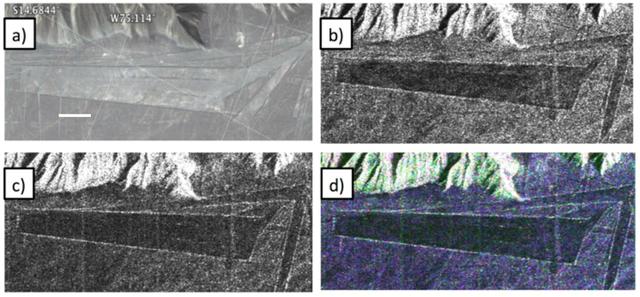
Different visualizations of an area with geometric geoglyphs at the Nasca World Heritage Site in Peru as seen by NASA Uninhabited Aerial Vehicle Synthetic Aperture Radar UAVSAR.
Peruvian Geometric Geoglyphs Detected by NASA UAVSAR
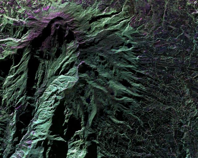
This false-color image of Peru Ubinas volcano was acquired on April 14, 2014, by NASA UAVSAR. Located about 100 miles 160 kilometers from the city of Arequipa, Ubinas is Peru most active volcano.
UAVSAR image of Ubinas Volcano
This image is a false-color composite of three channels of the UAVSAR polarimetric data acquired over the San Andreas Fault west of San Mateo, California.
Scientists Search for a Pulse in Skies Above Earthquake Country
NASA flew an aircraft equipped with Uninhabited Aerial Vehicle Synthetic Aperture Radar (UAVSAR) flew above California fires on Sept. 3 and 10. The smoke-penetrating UAVSAR enables scientists to get a close-up view of how these fires have a…
NASA's UAVSAR Flights Observe California Fires
This image shows a small part of the Hofsjökull ice cap in Iceland, which encompasses several glaciers. The fan at upper left is part of a glacier called Mûlaj&oumlkul.
NASA Radar Maps the Winter Pace of Iceland Glaciers
NASA's Gulfstream-III research testbed lifts off from Edwards AFB on a checkout test flight with the UAV synthetic aperture radar pod under its belly.
ED07-0027-66
C-20A crew chief Isac Mata stows metal pins used to secure the landing gear, while Ian Elkin, operations engineer, boards the aircraft to prepare for takeoff from NASA’s Armstrong Flight Research Center in Edwards, California, on Wednesday,…
NASA C-20A Enables Missions Advancing Earthquake Science
An eight-foot-long pod designed to carry a synthetic aperture radar hangs from the underbelly of NASA's Gulfstream-III research testbed.
ED07-0027-54
NASA’s C-20A takes off from NASA’s Armstrong Flight Research Center in Edwards, California, on Wednesday, April 29, 2026. The aircraft conducted science flights over Central California carrying NASA’s UAVSAR (Uninhabited Aerial Vehicle Synt…
NASA C-20A Enables Missions Advancing Earthquake Science
Shimmering heat waves trail behind NASA's Gulfstream-III research aircraft as it departs the Edwards AFB runway on a UAVSAR pod checkout test flight.
ED07-0027-68
The Uninhabited Aerial Vehicle Synthetic Aperture Radar, UAVSAR, is prepared for installation onto NASA’s C-20A aircraft.  THE UAVSAR uses a technique called interferometry to detect and measure very subtle deformations in the Earth’s surfa…
UAVSAR pod install
The Uninhabited Aerial Vehicle Synthetic Aperture Radar, UAVSAR, is prepared for installation onto NASA’s C-20A aircraft.  THE UAVSAR uses a technique called interferometry to detect and measure very subtle deformations in the Earth’s surfa…
UAVSAR pod install
JPL researchers Cathleen Jones (far left) and Yunling Lou (far right) stand with the flight crew in front of the airplane used to fly the UAVSAR instrument on Oct. 6. The plane is based out of NASA's Armstrong Flight Research Center near Pa…
UAVSAR Flight Crew
This radar image from NASA Uninhabited Aerial Vehicle Synthetic Aperture Radar UAVSAR shows the deformed Earth caused by a 7.2 earthquake in Mexico state of Baja California and parts of the American Southwest on April 4, 2010.
NASA Radar Captures Earth Deformation from 2010 Baja Calif. Quake
NASA Model Provides 3-D Look at L.A.-area 5.1 Quake
This radar image from NASA Uninhabited Aerial Vehicle Synthetic Aperture Radar UAVSAR shows the deformed Earth caused by a 7.2 earthquake in Mexico state of Baja California in 2010.
NASA Radar Images Show How Mexico Quake Deformed Earth
This false-color image of Colombia Galeras Volcano, was acquired by UAVSAR on March 13, 2013. A highly active volcano, Galeras features a breached caldera and an active cone that produces numerous small to moderate explosive eruptions.
UAVSAR Acquires False-Color Image of Galeras Volcano, Colombia
A protected area within the Nasca World Heritage Site in Peru that has experienced apparent disturbance between two different observations by NASA Uninhabited Aerial Vehicle Synthetic Aperture Radar UAVSAR.
Disturbance on Dirt Roads Crossing Peru Nasca World Heritage Site seen by NASA UAVSAR
 NASA Dryden lead technician David Neufeld prepares JPL's unmanned aircraft Synthetic Aperture Radar pod for inertial swing tests in Dryden's loads laboratory.
ED06-0200-07
A forest of tufts are mounted on the underbelly and pylon of NASA's Gulfstream-III research aircraft to help engineers determine airflow around the UAVSAR pod.
ED07-0027-01
The synthetic aperture radar pod developed by JPL is slung beneath NASA's Gulfstream-III research testbed during flight tests.
ED07-0027-45
A half-dozen test flights in early 2007 evaluated the aerodynamic effect of the UAVSAR pod on the performance of NASA's Gulfstream-III research testbed.
ED07-0027-56
The effect of the underbelly UAVSAR pod on the aerodynamics of NASA's Gulfstream-III research aircraft was evaluated during several check flights in early 2007.
ED07-0042-05
The Uninhabited Aerial Vehicle Synthetic Aperture Radar, UAVSAR, is prepared for installation onto NASA’s C-20A aircraft.  THE UAVSAR uses a technique called interferometry to detect and measure very subtle deformations in the Earth’s surfa…
UAVSAR pod install
The Uninhabited Aerial Vehicle Synthetic Aperture Radar, UAVSAR, is prepared for installation onto NASA’s C-20A aircraft.  THE UAVSAR uses a technique called interferometry to detect and measure very subtle deformations in the Earth’s surfa…
UAVSAR pod install
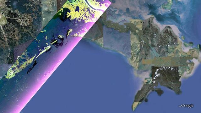
This false-color composite image from NASA UAVSAR taken on June 23, 2010, shows the southern Louisiana coastline, covering the area around Grande Isle and the entrance to Barataria Bay.
UAVSAR Maps the Gulf Coast Oil Spill
NASA Uninhabited Aerial Vehicle Synthetic Aperture Radar UAVSAR captured this false-color composite image of the city of Port-au-Prince, Haiti, and the surrounding region on Jan. 27, 2010.
NASA Airborne Radar Captures Its First Images of Post-Quake Haiti
On March 17, 2013, NASA Uninhabited Aerial Vehicle Synthetic Aperture Radar UAVSAR acquired synthetic aperture radar data over the Napo River in Ecuador and Peru.
NASA Sends Unmanned Aircraft To Study Volcanoes and Wetlands
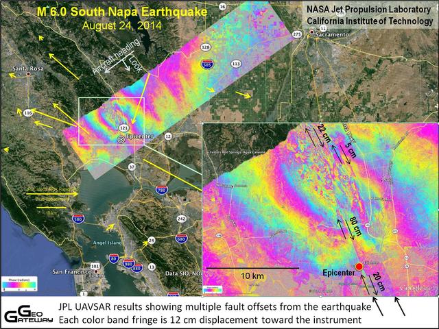
NASA UAVSAR studies ground deformation after a magnitude 6.0 South Napa earthquake on August 24, 2014.
NASA UAVSAR Studies Ground Deformation from Napa California Quake
An oil spill off the Southern California coast – first reported to the U.S. Coast Guard on Oct. 2, 2021 – prompted an effort by NASA's Applied Sciences Disasters Program to determine what NASA resources and capabilities could be available t…
UAVSAR Oil Slicks
JPL Uninhabited Aerial Vehicle Synthetic Aperture Radar collected this composite radar image around Québec City, Canada, during an 11-day campaign to study the structure of temperate and boreal forests.
UAVSAR Radar Imagery of Boreal Forests Around Quebec City, Canada
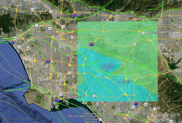
This image shows a UAVSAR interferogram swath overlaid atop a Google Earth image. New NASA airborne radar images show the continuing deformation in Earth surface resulting from the magnitude 7.2 temblor in Baja California on April 4, 2010.
NASA Radar Images Show Continued Deformation from Mexico Quake
NASA's Gulfstream-III research testbed lifts off the Edwards AFB runway on an envelope-expansion flight test with the UAV synthetic aperture radar pod.
ED07-0027-39
Alvin Mitchell, a NASA C-20A aircraft quality assurance inspector, completes preflight checks at NASA’s Armstrong Flight Research Center in Edwards, California, on Wednesday, April 29, 2026. The aircraft conducted science flights over Centr…
NASA C-20A Enables Missions Advancing Earthquake Science
NASA’s C-20A takes off from NASA’s Armstrong Flight Research Center in Edwards, California, on Wednesday, April 29, 2026. The aircraft conducted science flights over Central California carrying NASA’s UAVSAR (Uninhabited Aerial Vehicle Synt…
NASA C-20A Enables Missions Advancing Earthquake Science
The UAVSAR underbelly pod is in clear view as NASA's Gulfstream-III research aircraft banks away over Edwards AFB during aerodynamic clearance flights.
ED07-0042-09
NASA’s C-20A takes off from NASA’s Armstrong Flight Research Center in Edwards, California, on Wednesday, April 29, 2026. The aircraft conducted science flights over Central California carrying NASA’s UAVSAR (Uninhabited Aerial Vehicle Synt…
NASA C-20A Enables Missions Advancing Earthquake Science
The Uninhabited Aerial Vehicle Synthetic Aperture Radar, UAVSAR, is prepared for installation onto NASA’s C-20A aircraft.  THE UAVSAR uses a technique called interferometry to detect and measure very subtle deformations in the Earth’s surfa…
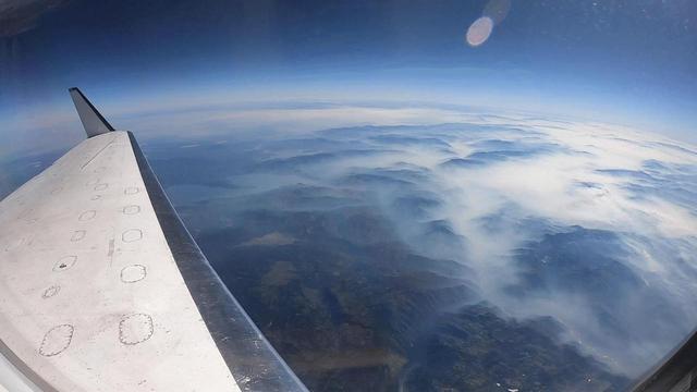
UAVSAR pod critical lift
A C-20 based at NASA’s Armstrong Flight Research Center in Edwards, California, departs to use its Uninhabited Aerial Vehicle Synthetic Aperture Radar to support the Marine Oil Spill Thickness mission. Thousands of gallons of oil seep throu…
C-20 Flights Support Sensing TechnologyFlight
No more images