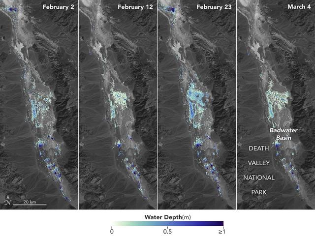
California's Death Valley, the driest place in North America, has hosted an ephemeral lake since late 2023. In March 2024, a NASA-led analysis calculated water depths in the temporary lake over several weeks in February and March 2024, demo…

This animation shows global sea level data collected by the Surface Water and Ocean Topography (SWOT) satellite during its first 21-day science orbit, which it completed from July 26 to Aug. 16, 2023. Red and orange indicate ocean heights…

The U.S.-French SWOT (Surface Water and Ocean Topography) satellite captured the leading edge of a tsunami wave that rolled through the Pacific Ocean on July 30, 2025 (11:25 a.m. local time), in the wake of a magnitude 8.8 earthquake that s…

This video is a series of images showing the deployment of the solar arrays that power the international Surface Water and Ocean Topography satellite (SWOT). The mission captured the roughly 10-minute process with two of the four commercial…

On June 27, 2021, teams from NASA's Jet Propulsion Laboratory in Southern California and the March Air Reserve Base in Riverside County, California, loaded the scientific heart of the Surface Water and Ocean Topography (SWOT) mission into a…

This illustration depicts the Surface Water and Ocean Topography satellite, a mission led by NASA and the French space agency Centre National d'Études Spatiales (CNES). The scientific heart of the SWOT satellite is the Ka-band Radar Interfe…

On June 27, 2021, teams from NASA's Jet Propulsion Laboratory in Southern California and the March Air Reserve Base in Riverside County, California, loaded the scientific heart of the Surface Water and Ocean Topography (SWOT) mission into a…

Members of the international Surface Water and Ocean Topography (SWOT) mission test one of the antennas for the Ka-band Radar Interferometer (KaRIn) instrument in a clean room at NASA's Jet Propulsion Laboratory in Southern California. The…

The solar panels on the Surface Water and Ocean Topography (SWOT) satellite unfold as part of a test in January 2022 at a Thales Alenia Space manufacturing facility near Cannes, France. The SWOT mission is being jointly led by NASA and the…

This visualization shows sea surface height measurements in the Gulf Stream off the coast of North Carolina and Virginia. The data was collected on Jan. 21, 2023, by an instrument on the Surface Water and Ocean Topography (SWOT) satellite c…

The Surface Water and Ocean Topography (SWOT) satellite arrives at Vandenberg Space Force Base in California on Oct. 16, 2022. SWOT is the first mission that will observe nearly all water on Earth’s surface, measuring the height of water in…

The Surface Water and Ocean Topography (SWOT) spacecraft is moved into a transport container inside the Astrotech facility at Vandenberg Space Force Base in California on Nov. 18, 2022. The satellite will be transported to the SpaceX facili…

Inside the SpaceX facility at Vandenberg Space Force Base in California, a crane is used to lift the Surface Water and Ocean Topography (SWOT) satellite for mating to the payload adapter on Dec. 5, 2022. A collaboration between NASA and the…

Inside the SpaceX facility at Vandenberg Space Force Base in California, the first half of the SpaceX Falcon 9 payload fairing is moved around the Surface Water and Ocean Topography (SWOT) satellite on Dec. 8, 2022. To mark the milestone, m…

The ground service equipment for the Surface Water and Ocean Topography (SWOT) satellite arrives at Vandenberg Space Force Base in California on Oct. 13, 2022. SWOT is the first mission that will observe nearly all water on Earth’s surface,…

Inside the SpaceX facility at Vandenberg Space Force Base in California, a technician assists as a crane lowers the Surface Water and Ocean Topography (SWOT) satellite onto the payload adapter on Dec. 5, 2022. A collaboration between NASA a…

The new international satellite mission called Surface Water and Ocean Topography (SWOT) — slated for launch in late 2022 — will measure the height of Earth's surface water. The data the spacecraft will collect will help researchers underst…

Flooding from monsoon rains covers a wide region of northeast Bangladesh near the India border in this Oct. 8, 2023, image showing data from the U.S.-French Surface Water and Ocean Topography (SWOT) satellite. Around that time, heavy monsoo…

This visualization based on data from the Surface Water and Ocean Topography (SWOT) satellite shows the average water level for lakes and reservoirs in the Ohio River Basin from July 2023 to November 2024. Yellow indicates values greater t…

This data visualization image above shows sea surface heights off the northern California coast in August 2023 as measured by the Surface Water and Ocean Topography (SWOT) satellite. Red indicates higher-than-average ocean heights, wh…

This illustration depicts the Surface Water and Ocean Topography (SWOT) satellite, a mission led by NASA and the French space agency Centre National d'Études Spatiales (CNES). The scientific heart of the SWOT satellite is the Ka-band Radar…

This illustration depicts the Surface Water and Ocean Topography (SWOT) satellite with solar arrays fully deployed. Arranged on opposite sides of the spacecraft bus, the two arrays will remain pointed at the Sun via small motors to provide…

This illustration depicts the Surface Water and Ocean Topography (SWOT) satellite with solar arrays fully deployed. Measuring 48.8 feet (14.9 meters) in length with an area of 335 square feet (31 square meters), the two arrays will remain p…

On June 27, 2021, teams from NASA's Jet Propulsion Laboratory in Southern California and the March Air Reserve Base in Riverside County, California, loaded the scientific heart of the Surface Water and Ocean Topography (SWOT) mission into a…

The international Surface Water and Ocean Topography (SWOT) satellite is shown in orbit over Earth in this illustration, with sunlight glinting off one of its solar arrays and both antennas of its Ka-band Radar Interferometer (KaRIn) instru…

The mighty Yukon River and nearby lakes appear in red in this image produced using data recorded on June 18, 2023, by the international Surface Water and Ocean Topography (SWOT) satellite as it passed over Alaska. The satellite measures the…

This animation, created in 2012, shows the increasing clarity and detail of measurements of sea height made by successive satellite altimeters launched by NASA and other agencies over the past four decades, concluding with data at the resol…

Inside the SpaceX facility at Vandenberg Space Force Base in California, the first half of the SpaceX Falcon 9 payload fairing is moved around the Surface Water and Ocean Topography (SWOT) satellite on Dec. 8, 2022. To mark the milestone, m…

A container, with the Surface Water and Ocean Topography (SWOT) spacecraft inside, is moved to a trailer at the Astrotech facility at Vandenberg Space Force Base in California on Nov. 19, 2022. The satellite will be transported to the Space…

The Surface Water and Ocean Topography (SWOT) spacecraft is moved into a transport container inside the Astrotech facility at Vandenberg Space Force Base in California on Nov. 18, 2022. The satellite will be transported to the SpaceX facili…

The Surface Water and Ocean Topography (SWOT) spacecraft is moved into a transport container inside the Astrotech facility at Vandenberg Space Force Base in California on Nov. 18, 2022. The satellite will be transported to the SpaceX facili…

The Surface Water and Ocean Topography (SWOT) spacecraft is transported from Astrotech to the SpaceX facility at Vandenberg Space Force Base in California on Nov. 21, 2022. SWOT is the first mission that will observe nearly all water on Ear…

Inside the SpaceX facility at Vandenberg Space Force Base in California, the first half of the SpaceX Falcon 9 payload fairing is moved around the Surface Water and Ocean Topography (SWOT) satellite on Dec. 8, 2022. A collaboration between…

Inside the SpaceX facility at Vandenberg Space Force Base in California, a crane is used to lift the Surface Water and Ocean Topography (SWOT) satellite for mating to the payload adapter on Dec. 5, 2022. A collaboration between NASA and the…

A series of atmospheric rivers drenched California in February 2024, with record amounts of rainfall and hurricane-force winds sweeping across parts of the state. The Surface Water and Ocean Topography (SWOT) mission captured data on coasta…
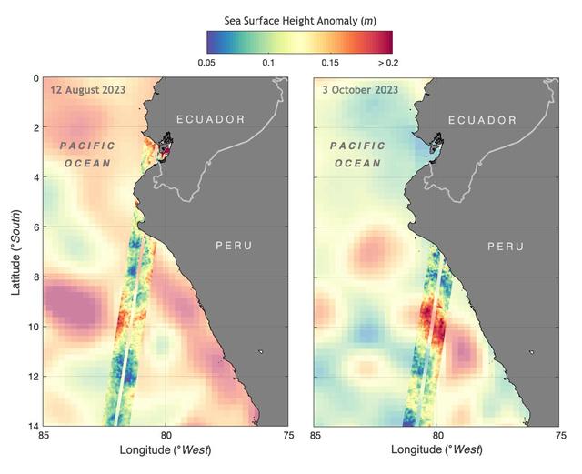
The illustration above shows sea levels off the coasts of Peru and Ecuador on Aug. 12, 2023, and Oct. 3, 2023. The Surface Water and Ocean Topography (SWOT) satellite collected the ocean data during its operational phase, which began in lat…

A visualization based on data from the international SWOT satellite mission shows the unique contours of a tsunami that sloshed within the steep walls of a fjord in Greenland in September 2023. Triggered by a massive landslide, the tsunami…

Technicians encapsulated the SWOT satellite, or the Surface Water and Ocean Topography mission, in its payload fairing on Dec. 8, 2022, in preparation for launch. At the SpaceX processing facility at Vandenberg Space Force Base in Californi…

Workers in a clean room in Cannes, France, load the Surface Water and Ocean Topography (SWOT) satellite into a container in preparation for shipping the spacecraft to the U.S. SWOT is an international mission led by NASA and the French spac…

Part of the Surface Water and Ocean Topography (SWOT) satellite's science instrument payload sits in a clean room at NASA's Jet Propulsion Laboratory during assembly. Once fully assembled and launched into orbit, the SUV-size spacecraft wi…

Some of the people who helped to load the hardware for the Surface Water and Ocean Topography (SWOT) satellite's research instruments onto a C-17 airplane pose for a picture. The payload left March Air Reserve Base in Riverside County, Cali…
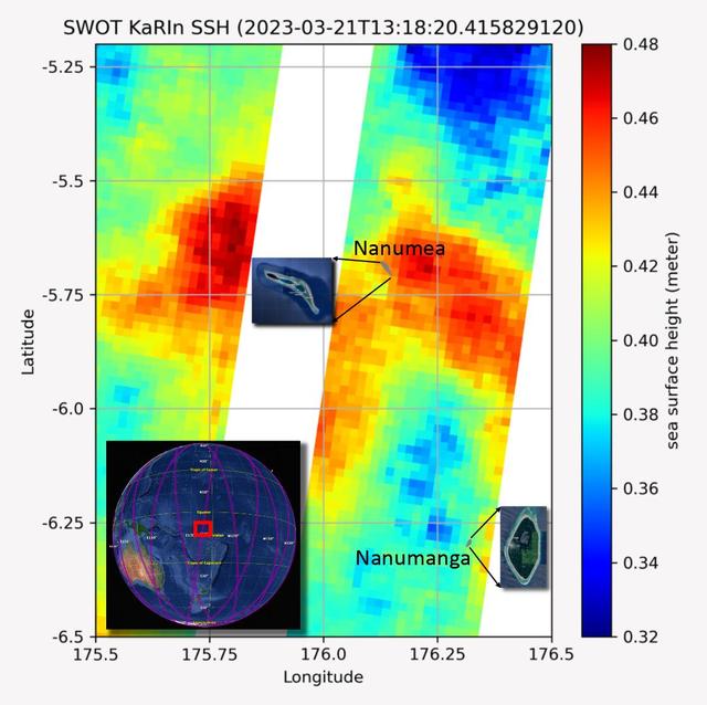
The recently launched Surface Water and Ocean Topography (SWOT) mission collected data on sea levels around two of the inhabited islands of Tuvalu, a nation in the South Pacific Ocean that has been threatened with sea level rise that substa…
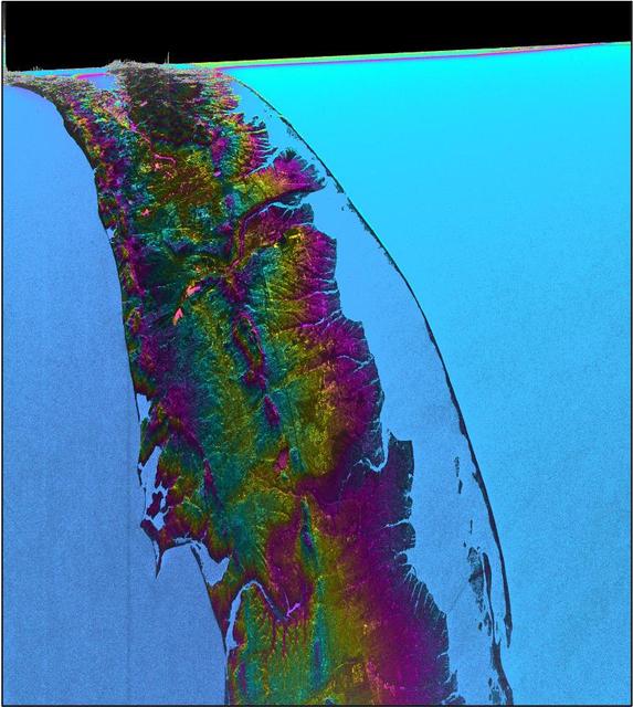
This visualization shows water features on New York's Long Island – shown as bright pink splotches nestled within the landscape. Purple, yellow, green, and dark blue shades represent different land elevations, while the surrounding ocean is…

NASA’s Surface Water and Ocean Topography (SWOT) satellite arrives from France aboard a U.S. Air Force C-5 Galaxy aircraft at Vandenberg Space Force Base in California, on Oct. 16, 2022. Teams will transport the satellite to Astrotech Space…

Inside the SpaceX facility at Vandenberg Space Force Base in California, a technician assists as a crane is used to lift the Surface Water and Ocean Topography (SWOT) satellite for mating to the payload adapter on Dec. 5, 2022. A collaborat…

The Surface Water and Ocean Topography (SWOT) spacecraft is transported from Astrotech to the SpaceX facility at Vandenberg Space Force Base in California on Nov. 21, 2022. SWOT is the first mission that will observe nearly all water on Ear…

The ground service equipment for the Surface Water and Ocean Topography (SWOT) satellite arrives at Vandenberg Space Force Base in California on Oct. 13, 2022. SWOT is the first mission that will observe nearly all water on Earth’s surface,…

The Surface Water and Ocean Topography (SWOT) spacecraft is moved into a transport container inside the Astrotech facility at Vandenberg Space Force Base in California on Nov. 18, 2022. The satellite will be transported to the SpaceX facili…