
NASA image acquired February 24, 2012 By late February, 2012, the great European cold wave had begun to loosen its frigid grip, but significant snow still remained in the region. The Moderate Resolution Imaging Spectroradiometer (MODIS) ab…
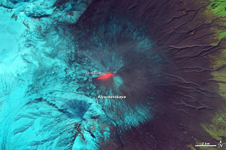
This false-color (shortwave infrared, near infrared, green) satellite image reveals an active lava flow on the western slopes of Klyuchevskaya Volcano. Klyuchevskaya is one of several active volcanoes on the Kamchatka Peninsula in far easte…

This image from the Aqua satellite's MODIS instrument taken at 11:10 UTC on December 16, 2013 shows areas of snow in Syria, Jordan, Israel and the Palestinian Territory. Snow storms in the Middle East are not frequent but not uncommon eith…
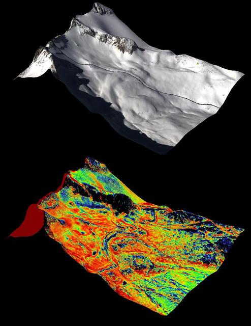
A natural color image of Mt. Lyell, the highest point in the Tuolumne River Basin top image is compared with a three-dimensional color composite image of Mt. Lyell from NASA Airborne Snow Observatory depicting snow depth bottom image.

An autumn storm brought the first snow of the season to the Upper Mississippi River Valley and the Midwestern United States in early November, 2013. The Moderate Resolution Imaging Spectroradiometer (MODIS) aboard NASA’s Terra satellite cap…

IDL TIFF file This false-color (shortwave infrared, near infrared, green) satellite image reveals an active lava flow on the western slopes of Klyuchevskaya Volcano. Klyuchevskaya is one of several active volcanoes on the Kamchatka Peninsu…

Increasing solar illumination brings increased phytoplankton growth to the Gulf of Alaska every spring, and this year is no exception. The above image was collected on May 2, 2014 several orbits of Aqua-MODIS. High res: <a href="http://oc…
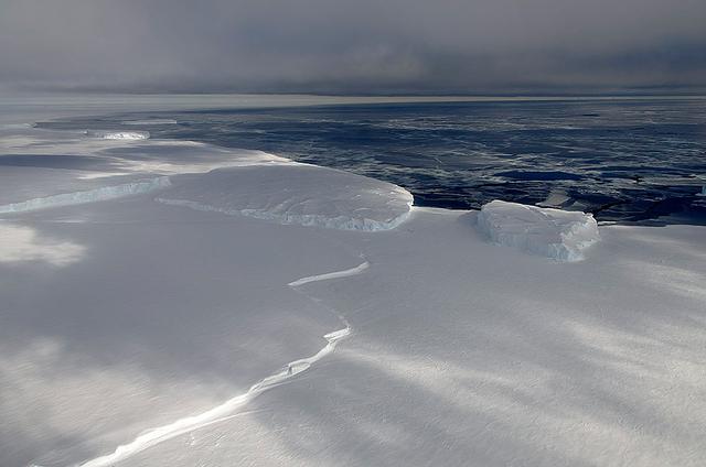
November 21, 2013 - NASA's Operation IceBridge P-3 landed a few minutes ago after a successful survey of sea ice in the Ross Sea. In this photo taken by project scientist Michael Studinger we see icebergs in Sulzberger Bay off of the easter…
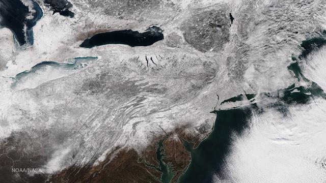
As the storm moves offshore and the skies clear over the Northeast United States, the extent of snowfall from the blizzard is shown in this image from the Suomi NPP satellite imagery, taken on January 28, 2015 at 1:50 EST. Portions of Suffo…

NASA image acquired November 2, 2011 The Moderate Resolution Imaging Spectroradiometer (MODIS) instrument on NASA's Terra satellite captured this image of the Knox, Budd Law Dome, and Sabrina Coasts, Antarctica on November 2, 2011 at 01:4…
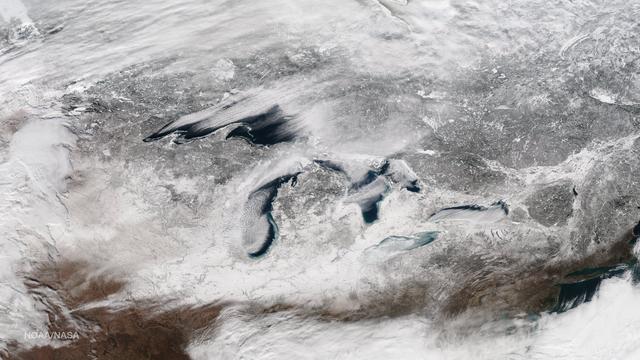
This image taken on January 13, 2015 from the Suomi NPP satellite's VIIRS instrument shows the Great Lakes and surrounding areas. The latest Great Lakes Surface Environmental Analysis (GLSEA) from the NOAA Great Lakes Environmental Research…

On August 22, 2014 the Moderate Resolution Imaging Spectroradiometer (MODIS) aboard NASA’s Terra satellite captured a true-color image of a sunny summer day in Iceland. While most of the winter snow has melted to reveal green vegetation, th…

Want to know what the North Pole looked like yesterday afternoon? Well, our friends from NASA Operation IceBridge brought us this view from 500 meters about the North Pole. So what are you seeing? That's sea ice, with a few ridges and a…

The green of St. Patrick's Day in the Mid-Atlantic was covered by white snow as a result of a late winter snow storm. The covering of the green was captured in a movie made at NASA using NOAA's GOES satellite data. The winter storm droppe…

Pumping helium into the first BARREL balloon to launch from Halley Research Satation. Credit: NASA --- In Antarctica in January, 2013 – the summer at the South Pole – scientists launched 20 balloons up into the air to study an enduring…

An emperor penguin waddles away on Christmas morning in Antarctica. On Christmas day, the BARREL team visited a penguin colony. Credit: NASA --- In Antarctica in January, 2013 – the summer at the South Pole – scientists launched 20 bal…

NASA image acquired December 19, 2012 In time for the 2012 winter solstice, a storm dropped snow over most of the Rocky Mountains in the United States. On December 20, the National Weather Service reported snow depths exceeding 100 centime…

As autumn colors moved across much of the lower forty-eight states in mid-October 2015, winter weather had already arrived in Alaska. The Moderate Resolution Imaging Spectroradiometer (MODIS) aboard NASA’s Terra satellite captured this true…

Snow covered the northeastern United States on last day of meteorological winter, 2014. Climatologists and meteorologists break seasons down into three-month groups, based on annual temperature and our calendar. This method is helpful for w…

Photo of NASA's Jet Propulsion Laboratory nestled in the Pasadena, Calif. hillside, taken in January, 2016.
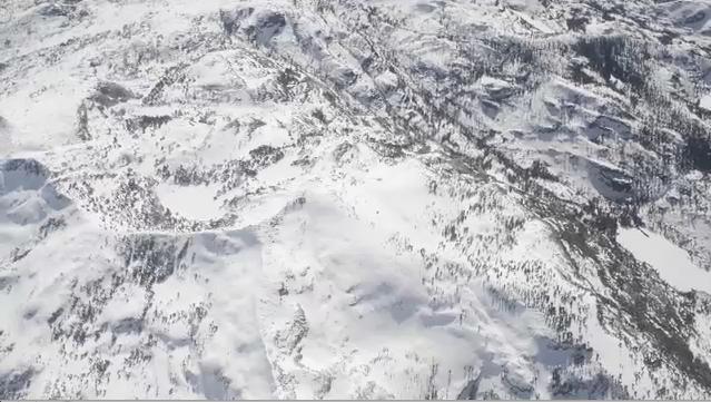
NASA Airborne Snow Observatory is two instruments combined that provides information on every patch of snow, including how deep it is and how fast it melting. This is a frame from an animation.

NASA Airborne Snow Observatory measurements of snow water equivalent top image and snow albedo, or reflectivity bottom image for the Tuolumne River Basin in California Sierra Nevada on April 21, 2013.

In February 2015, New England was not alone in dealing with the wrath of Old Man Winter. Thick snow blanketed mountain ranges in southwestern Europe after a winter storm pushed through the region in early February. The Moderate Resolution I…
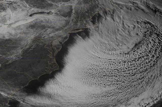
Yet another potent winter storm battered the northeastern United States on February 14-15, 2015. The nor'easter brought 12 to 20 inches (30 to 50 centimeters) of snow across much of eastern New England, along with tropical storm force winds…

Increasing solar illumination brings increased phytoplankton growth to the Gulf of Alaska every spring, and this year is no exception. This image was collected on May 9, 2014 during a single orbit of Aqua-MODIS. High res: <a href="http://…
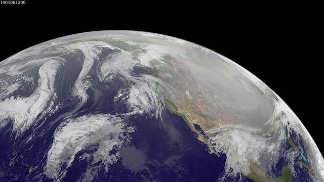
1-9 January 2014. The full-disk images every 3 hours from GOES-WEST capture the sweep of a polar vortex that emerged from the arctic at the beginning of the new year, pushing a blizzard into the northeastern USA on January 3, followed by ex…

Late winter photograph of a snow-covered NASA Insignia at the Glenn Research Center in Cleveland, OH.

Each winter sea ice forms over the salty waters of frigid northeastern Canada's Hudson Bay. As sunlight lengthens and weather warms, ice begins to break up and melt, with retreat typically starting in May and melt-out completed sometime in…
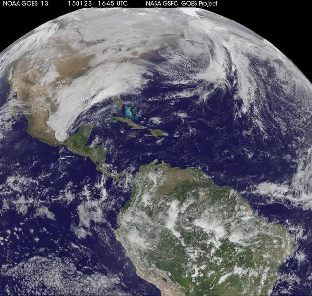
National Weather Service forecasters have been tracking a low pressure area that moved from the Midwest into the Atlantic Ocean today, and is expected to become a strong nor'easter that will bring blizzard conditions to the northeastern U.S…

A crane lowers two BARREL balloon payloads onto the platform at Halley Research Station in Antarctica. Credit: NASA --- In Antarctica in January, 2013 – the summer at the South Pole – scientists launched 20 balloons up into the air to…

A BARREL balloon floats into the sky as it is partially filled. When fully inflated, each balloon is 90 feet in diameter and carries an instrument suite that weighs 50 pounds. This is small for an Antarctica balloon launch, which can have b…

NASA's first ever historic P-3B landing in McMurdo Station, Antarctica on the sea ice runway, which occurred on Nov. 16, 2013. It took the craft 5 days to reach Antarctica from the NASA Wallops Flight Facility in Wallops Island, Virginia. Y…
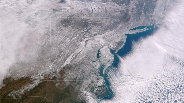
Clear, cold air following behind the winter storm of January 21, 2014 highlights the extent of snowfall in the Mid-Atlantic states. The frigid temperatures that remain entrenched over the central and eastern U.S. will begin to affect the so…
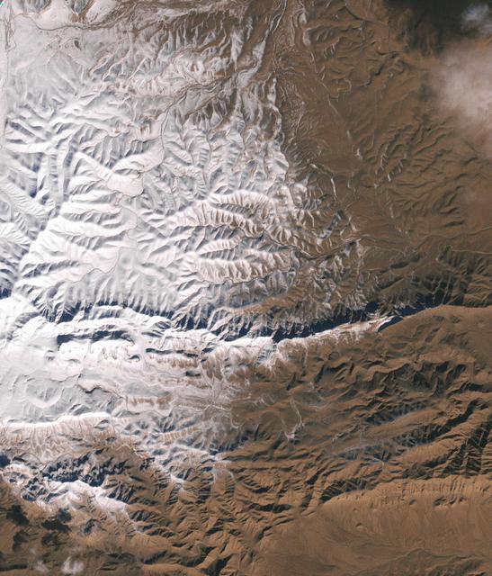
In December 2016, snow fell in the Sahara for the first time since 1979. In 1984, the charitable supergroup Band Aid sang: “There won’t be snow in Africa this Christmas time.” In fact, it does snow in Africa at high elevations. Kilimanjaro…

On Nov. 22, 2015 at 19:15 UTC the MODIS instrument aboard NASA's Aqua satellite captured this image of Snow across the Midwest. Credit: NASA Goddard MODIS Rapid Response Team NASA image use policy. NASA Goddard Space Flight Center enable…

Spatial distribution of snow water equivalent across the Tuolumne River Basin from April 10 to June 1, 2013 as measured by NASA Airborne Snow Observatory.

Mt. Dana and Dana Plateau in the Tuolumne River Basin within Yosemite National Park, Calif., as seen out the window of a Twin Otter aircraft carrying NASA Airborne Snow Observatory on April 3, 2013.

A combination of the day-night band and high resolution infrared imagery from the NASA-NOAA's Suomi NPP satellite showed the record-setting winter storm along the Mid-Atlantic and the northeastern U.S. at 06:55 UTC (1:55 a.m. EST) on Januar…

This image from NOAA's GOES satellite shows the swaths of snow across the Midwest after the weekend storms (December 7 and 8) there. This visible image was captured at 1745 UTC/12:45 p.m. EST on December 10, 2013. The riverine topography i…

Iceland, dressed in winter white, peaked through a hole in a complex system of clouds in late February, 2015. The Moderate Resolution Imaging Spectroradiometer (MODIS) aboard NASA’s Terra satellite captured this true-color image on February…

Just like drivers sometimes use snow to clean their car mirrors in winter, two Exelis Inc. engineers are practicing "snow cleaning'" on a test telescope mirror for the James Webb Space Telescope at NASA's Goddard Space Flight Cent…

The U.S. National Weather Service called it a “a crippling and historic winter blizzard.” In late January 2015, transportation systems from Trenton to Portland were shut down, and more than 35 million people hunkered down for extreme snowfa…

Antarctica is the coldest, driest and windiest place on Earth – and, during the austral summer, it is also the sunniest. Due to the tilt of the Earth’s axis in relation of the sun, the frozen land south of the Antarctic Circle receives six…

Alaskan mountains seen from high altitude aboard the NASA P-3B during the IceBridge transit flight from Thule to Fairbanks on Mar. 21, 2013. NASA's Operation IceBridge is an airborne science mission to study Earth's polar ice. For more in…

NASA's Aqua satellite observed swirls of sea ice along the coast of Greenland on December 30, 2012. Credit: NASA/GSFC/Jeff Schmaltz/MODIS Land Rapid Response Team <b><a href="http://www.nasa.gov/audience/formedia/features/MP_Photo_Guideli…

The U.S. National Weather Service called it a “a crippling and historic winter blizzard.” In late January 2015, transportation systems from Trenton to Portland were shut down, and more than 35 million people hunkered down for extreme snowfa…

The storm system that moved through the northeastern U.S. dropped large snowfall totals up to a foot in southern New England to a couple of inches in Virginia. On January 22, 2014, the day after the event, the Moderate Resolution Imaging Sp…
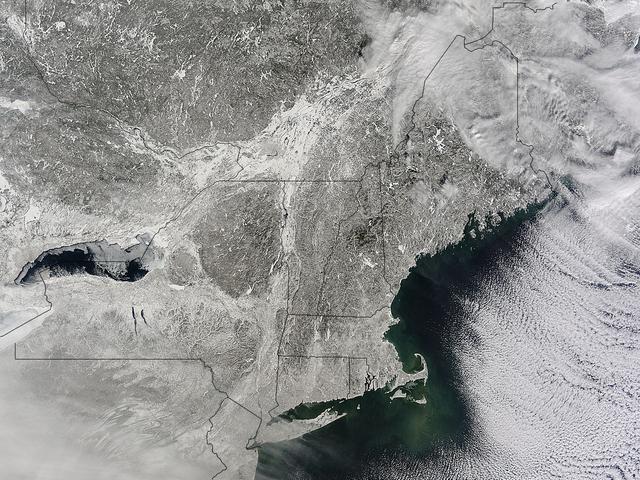
A winter storm that moved through the Mid-Atlantic on Feb. 16 and 17, 2015 extended the northeastern U.S. snowcover farther south. Until this storm hit, southern New Jersey and southeastern Pennsylvania appeared snow-free on satellite image…