KENNEDY SPACE CENTER, FLA. -- NASA's Comet Nucleus Tour    (CONTOUR) spacecraft successfully launches at 2:47:41 a.m. EDT aboard a Boeing Delta II rocket from Cape Canaveral Air Force Station, Fla. Designed and built by The Johns Hopkins Un…
KSC-02pp1125
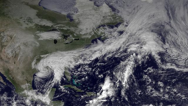
The system that brought heavy rainfall and flash flooding to parts of the southern Plains and western Gulf Coast over the past several days continues to push eastward, with the greatest potential for heavy rain and flash flooding on Monday…
Heavy Rain, Flash Flooding Possible Across Parts of Lower Mississippi Valley, Southeast
This is an image of equatorial Africa, centered on the equator at longitude 15degrees east. This image is a mosaic of almost 4,000 separate images obtained in 1996 by the L-band imaging radar onboard the Japanese Earth Resources Satellite.…
Radar Mosaic of Africa
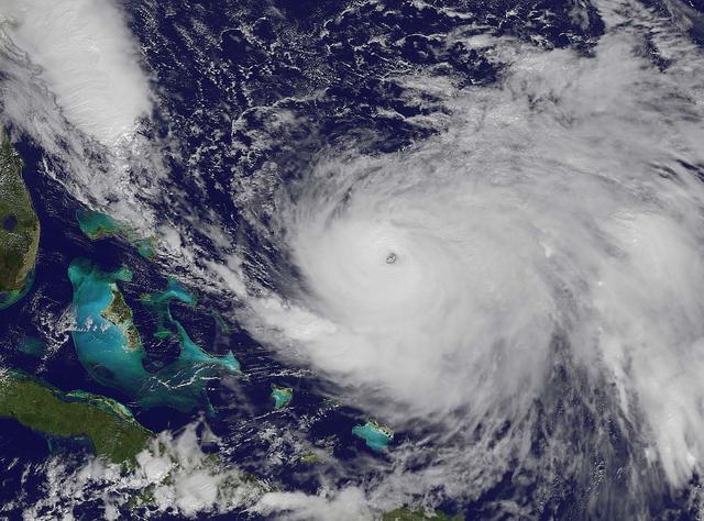
NOAA's GOES-East satellite captured this visible image of Hurricane Joaquin east of the Bahamas on Oct. 3 at 1615 UTC (12:15 p.m. EDT).  The national weather forecast for October 3, 2015: Joaquin is no threat for now, but the nor'easter on…
Joaquin moves away from East Coast
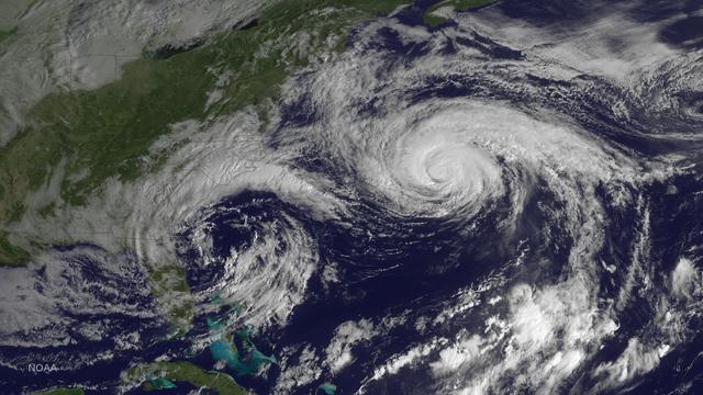
Hurricane Joaquin is seen in the Atlantic Ocean north of Bermuda in this image taken by GOES East at 1315 UTC (9:15 a.m. EDT) on October 5, 2015.  Credit: NASA/NOAA via <b><a href="www.nnvl.noaa.gov/" rel="nofollow"> NOAA Environmental Visu…
Hurricane Joaquin North of Bermuda
Despite a somewhat ragged appearance on satellite imagery, Arthur has strengthened overnight. NOAA and Air Force Reserve Hurricane Hunter aircraft have found surface winds in the 45-50 kt range to the south and northeast of the center, whil…
Arthur Strengthens, Moves Northward
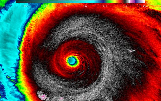
When NASA-NOAA's Suomi NPP satellite passed over Patricia on October 23 at 5:20 a.m. EDT the VIIRS instrument that flies aboard Suomi NPP looked at the storm in infrared light. Cloud top temperatures of thunderstorms around the eyewall were…
NASA Analyzes Record-Breaking Hurricane Patricia
NOAA's GOES-East satellite captured this visible image of Hurricane Joaquin east of the Bahamas on Oct. 3 at 1615 UTC (12:15 p.m. EDT).  The national weather forecast for October 3, 2015: Joaquin is no threat for now, but the nor'easter on…
Joaquin moves away from East Coast
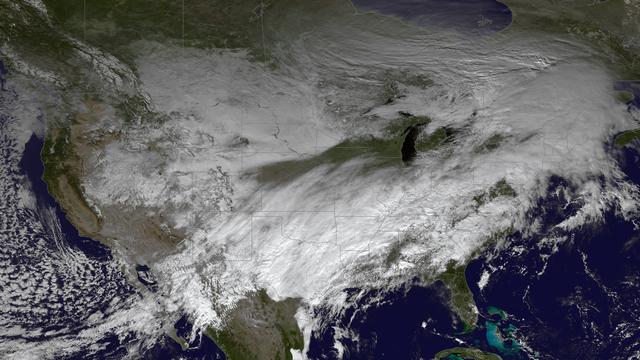
The powerful winter storm that has been affecting much of the central and western U.S. continues to intensify as it moves into Canada. Snow is tapering off across the Upper Midwest, but heavy snow is possible on Thursday from the Ohio Valle…
Winter Storm Continues Across Central U.S.
NASA's DC-8 flying laboratory seen at sunset after a flight supporting the AirSAR 2004 Mesoamerica campaign. AirSAR 2004 Mesoamerica is a three-week expedition by an international team of scientists that uses an all-weather imaging tool, ca…
NASA's DC-8 flying laboratory seen at sunset after a flight supporting the AirSAR 2004 Mesoamerica campaign
A spider photographed during NASA's AirSAR 2004 Mesoamerica campaign in the La Selva region of the Costa Rican rain forest. AirSAR 2004 Mesoamerica is a three-week expedition by an international team of scientists that uses an all-weather i…
A spider photographed during NASA's AirSAR 2004 Mesoamerica campaign in the La Selva region of the Costa Rican rain forest
This photograph shows a stream in the La Selva region of the Costa Rican rain forest, taken during NASA's AirSAR 2004 campaign. AirSAR 2004 Mesoamerica is a three-week expedition by an international team of scientists that uses an all-weath…
This photograph shows a stream in the La Selva region of the Costa Rican rain forest, taken during NASA's AirSAR 2004 campaign
A plant photographed in the La Selva region of the Costa Rican rain forest as part of NASA's AirSAR 2004 Mesoamerica campaign. AirSAR 2004 Mesoamerica is a three-week expedition by an international team of scientists that will use an all-we…
A plant photographed in the La Selva region of the Costa Rican rain forest as part of NASA's AirSAR 2004 Mesoamerica campaign
NASA Dryden Mission Manager Walter Klein passes out Airborne Science stickers and lithographs to underprivileged school children that visited the airport on Monday March 8, 2004. In spanish, he explained to them the mission of the DC-8 AirS…
DFRC Mission Manager Walter Klein passes out stickers and lithographs to underprivileged Costa Rican school children that visited the airport on Monday March 8, 2004
Pre-Columbian archaeological ruins are revealed through Costa Rican rain forest in this photo taken during NASA's AirSAR 2004 Mesoamerica campaign. AirSAR 2004 Mesoamerica is a three-week expedition by an international team of scientists th…
Pre-Columbian archaeological ruins are revealed through Costa Rican rain forest in this photo taken during NASA's AirSAR 2004 campaign
NASA Dryden Mission Manager Walter Klein passes out Airborne Science stickers and lithographs to underprivileged school children that visited the airport on Monday March 8, 2004. In spanish, he explained to them the mission of the DC-8 AirS…
DFRC Mission Manager Walter Klein passes out stickers and lithographs to underprivileged Costa Rican school children that visited the airport on Monday March 8, 2004
Pre-Columbian archaeological ruins are revealed through Costa Rican rain forest in this photo taken during NASA's AirSAR 2004 Mesoamerica campaign. AirSAR 2004 Mesoamerica is a three-week expedition by an international team of scientists th…
Pre-Columbian archaeological ruins are revealed through Costa Rican rain forest in this photo taken during NASA's AirSAR 2004 campaign
KENNEDY SPACE CENTER, FLA. -- The Boeing Delta II rocket carrying NASA's Comet Nucleus Tour (CONTOUR) spacecraft streaks across the night sky above pad 17-A, Cape Canaveral Air Force Station. The launch took place at 2:47:41 a.m. EDT July 3…
KSC-02pp1124
S65-63830 (5 Dec. 1965) --- Algeria, south-southeast of the Colomb Bechar area, as seen from the National Aeronautics and Space Administration's Gemini-7 spacecraft. Sand dunes are 200 to 300 feet high in the Grand Erg Occidental area. The…
Algeria- Gemini 7, Earth-Sky View
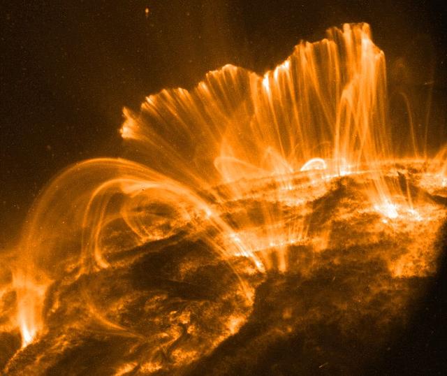
Explanation: In this picture, the Sun's surface is quite dark. A frame from a movie recorded on November 9th by the orbiting TRACE telescope, it shows coronal loops lofted over a solar active region. Glowing brightly in extreme ultraviolet…
Coronal Rain, Solar Storm
NASA's Aqua satellite captured this image of Hurricane Joaquin over the Bahamas on Oct. 1 at 17:55 UTC (1:55 p.m. EDT).  Recently upgraded to Category 4, Hurricane Joaquin has maximum sustained winds of 130 mph which may grow stronger.  Cre…
Hurricane Joaquin over the Bahamas
The MODIS instrument on NASA's Aqua satellite captured this visible image of Tropical Storm Isaac on Aug. 27 at 3:00 p.m. EDT is it was moving northwest through the Gulf of Mexico. Issac's large reach is seen by its eastern cloud cover over…
NASA Watching Issac's Approach to U.S. Gulf Coast
Hurricane Joaquin continued to intensify in the Bahamas on October 1 and NASA and NOAA satellites have been providing valuable data on the storm. NASA's GPM and Terra satellites and NOAA's GOES-East satellite provided rainfall, cloud extent…
Latest View of Hurricane Joaquin
The remnant moisture from what was once Hurricane Patricia and moisture from the Gulf of Mexico were being transported north by a trough of low pressure over Wisconsin. The clouds and moisture were streaming into the Eastern third of the U.…
NASA Sees Post-Patricia Moisture, Winds Stalking the Mid-Atlantic
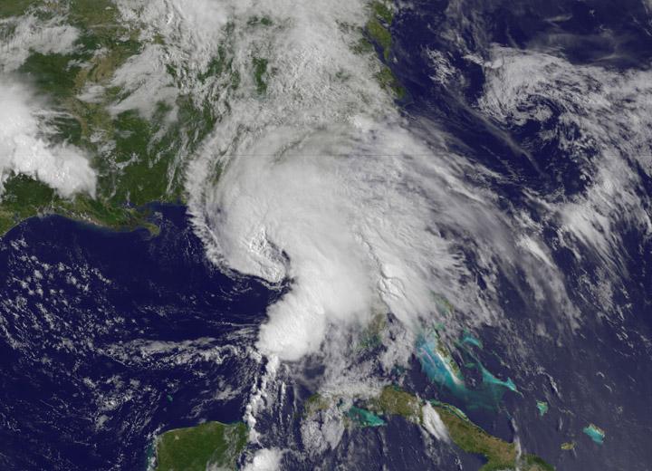
This image of tropical storm Andrea was assembled from data collected by NOAA's GOES-14 satellite at 8:31 a.m. EDT on June 7, when the storm's center was about 35 miles north-northwest of Charleston, S.C.   Credit: NASA/NOAA GOES Project  <…
Tropical Storm Andrea June 7, 2013
Dense rain forest in the La Selva region of Costa Rica. AirSAR 2004 Mesoamerica is a three-week expedition by an international team of scientists that uses an all-weather imaging tool, called the Airborne Synthetic Aperture Radar (AirSAR) w…
Dense rain forest in the La Selva region of Costa Rica
The large field patterns in this view of the Rio Sao Francisco basin, Brazil, South America, (11.5S, 43.5W) indicate a commercial agriculture venture; family subsistence farms are much smaller and laid out in different patterns. Land cleari…
Agriculture, Rio Sao Francisco, Brazil, South America
Pre-Columbian archaeological ruins are revealed through Costa Rican rain forest in this photo taken during NASA's AirSAR 2004 Mesoamerica campaign. AirSAR 2004 Mesoamerica is a three-week expedition by an international team of scientists th…
Pre-Columbian archaeological ruins are revealed through Costa Rican rain forest in this photo taken during NASA's AirSAR 2004 campaign
DC-8 Quality Inspector Scott Silver signs documents while Acting Crew Chief Mike Bereda looks on prior to a DC-8 AirSAR flight in Costa Rica. AirSAR 2004 Mesoamerica is a three-week expedition by an international team of scientists that use…
DC-8 Quality Inspector Scott Silver signs documents while Acting Crew Chief Mike Bereda looks on prior to a DC-8 AirSAR flight in Costa Rica
Pre-Columbian archaeological ruins are revealed through Costa Rican rain forest in this photo taken during NASA's AirSAR 2004 Mesoamerica campaign. AirSAR 2004 Mesoamerica is a three-week expedition by an international team of scientists th…
Pre-Columbian archaeological ruins are revealed through Costa Rican rain forest in this photo taken during NASA's AirSAR 2004 campaign
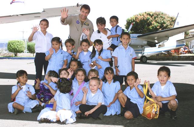
NASA Dryden Mission Manager Walter Klein poses with school children that visited the airport during AirSAR 2004. In spanish, he explained to them the mission of the DC-8 AirSAR 2004 Mesoamerican campaign in Costa Rica. AirSAR 2004 Mesoameri…
NASA Dryden Mission Manager Walter Klein poses with school children that visited the airport during AirSAR 2004
A tree trunk structure photographed in the La Selva region of the Costa Rican rain forest as part of NASA's AirSAR 2004 Mesoamerica campaign. AirSAR 2004 Mesoamerica is a three-week expedition by an international team of scientists that wil…
A tree trunk structure photographed in the La Selva region of the Costa Rican rain forest as part of NASA's AirSAR 2004 Mesoamerica campaign
A butterfly photographed in the La Selva region of the Costa Rican rain forest as part of NASA's AirSAR 2004 Mesoamerica campaign. AirSAR 2004 Mesoamerica is a three-week expedition by an international team of scientists that will use an al…
A butterfly photographed in the La Selva region of the Costa Rican rain forest as part of NASA's AirSAR 2004 Mesoamerica campaign
KENNEDY SPACE CENTER, FLA. -- NASA's Comet Nucleus Tour    (CONTOUR) spacecraft successfully launches at 2:47:41 a.m. EDT aboard a Boeing Delta II rocket from Cape Canaveral Air Force Station, Fla. Designed and built by The Johns Hopkins Un…
KSC-02pp1126
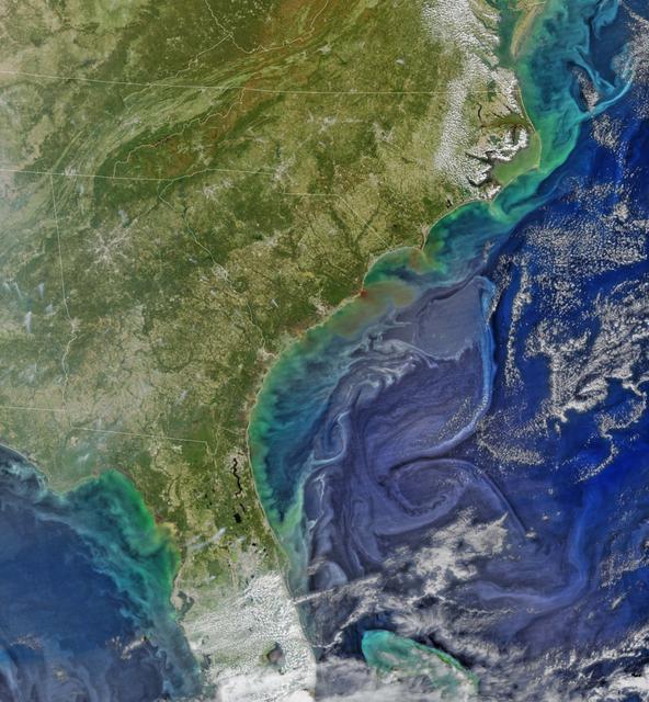
Damaging heavy rains fell on South Carolina in the southeastern United States at the beginning of October 2015. Much of that water had, by mid October, flowed into the Atlantic Ocean bringing with it heavy loads of sediment, nutrients, and…
Colors after the Storms
Hurricane Joaquin is seen in the Atlantic Ocean north of Bermuda in this image taken by GOES East at 1315 UTC (9:15 a.m. EDT) on October 5, 2015.  <b><a href="http://goes.gsfc.nasa.gov/" rel="nofollow">Credit: NOAA/NASA GOES Project</a></b>…
Hurricane Joaquin North of Bermuda
This NOAA GOES-East satellite animation shows the development of System 91L into Tropical Storm Andrea over the course of 3 days from June 4 to June 6, just after Andrea was officially designated a tropical storm.   Credit:  NASA's GOES Pro…
NASA Sees Heavy Rainfall in Tropical Storm Andrea
NASA Deputy Administrator Pam Melroy, left, speaks with Mel Raines, president and chief operating officer of Pacers Sports & Entertainment, before the start of a basketball game between the Indiana Pacers and the Miami Heat, Sunday, April 7…
NASA Deputy Administrator at Gainbridge Fieldhouse
NASA’s Terra satellite passed over Tropical Storm Andrea on June 5 at 16:25 UTC (12:25 p.m. EDT) and the MODIS instrument captured this visible image of the storm. Andrea’s clouds had already extended over more than half of Florida.    Cred…
NASA Sees Heavy Rainfall in Tropical Storm Andrea
NASA's DC-8 flying laboratory seen at sunset after a flight supporting the AirSAR 2004 Mesoamerica campaign. AirSAR 2004 Mesoamerica is a three-week expedition by an international team of scientists that uses an all-weather imaging tool, ca…
NASA's DC-8 flying laboratory seen at sunset after a flight supporting the AirSAR 2004 Mesoamerica campaign
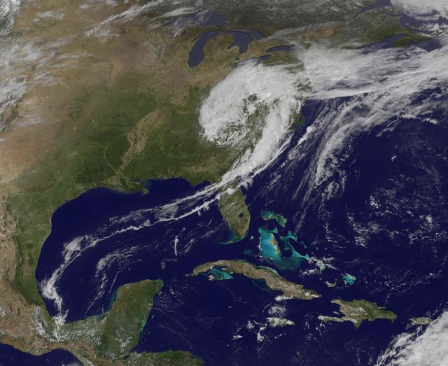
NASA image captured April 12, 2011 at 1731 UTC (1:31 p.m. EDT)  A giant swirl of clouds that form an apostrophe-like shape over the eastern U.S. was spotted in visible imagery from the Geostationary Operational Environmental Satellite, GOES…
GOES-13 Satellite Sees a "Giant Apostrophe" from Strong Eastern U.S. Low Pressure
NASA's DC-8 flying laboratory takes off from Juan Santamaria International Airport in San Jose, Costa Rica, on NASA's AirSAR 2004 campaign. AirSAR 2004 Mesoamerica is a three-week expedition by an international team of scientists that uses…
NASA's DC-8 flying laboratory takes off from Juan Santamaria International Airport in San Jose, Costa Rica, on NASA's AirSAR 2004 campaign
Pre-Columbian archaeological ruins are revealed through Costa Rican rain forest in this photo taken during NASA's AirSAR 2004 Mesoamerica campaign. AirSAR 2004 Mesoamerica is a three-week expedition by an international team of scientists th…
Pre-Columbian archaeological ruins are revealed through Costa Rican rain forest in this photo taken during NASA's AirSAR 2004 campaign
This photograph shows a stream in the La Selva region of the Costa Rican rain forest, taken during NASA's AirSAR 2004 Mesoamerica campaign. AirSAR 2004 Mesoamerica is a three-week expedition by an international team of scientists that will…
This photograph shows a stream in the La Selva region of the Costa Rican rain forest, taken during NASA's AirSAR 2004 Mesoamerica campaign
NASA Dryden DC-8 maintenance crew members inspect the aircraft prior to take-off. L-R; Scott Silver, Paul Ristrim and Mike Lakowski. AirSAR 2004 Mesoamerica is a three-week expedition by an international team of scientists that uses an all-…
NASA Dryden DC-8 maintenance crew members inspect the aircraft prior to take-off for an AirSAR 2004 flight
A lizard photographed in the La Selva region of the Costa Rican rain forest as part of NASA's AirSAR 2004 Mesoamerica campaign. AirSAR 2004 Mesoamerica is a three-week expedition by an international team of scientists that will use an all-w…
A lizard photographed in the La Selva region of the Costa Rican rain forest as part of NASA's AirSAR 2004 Mesoamerica campaign
NASA Dryden Mission Manager Walter Klein passes out Airborne Science stickers and lithographs to underprivileged school children that visited the airport on Monday March 8, 2004. In spanish, he explained to them the mission of the DC-8 AirS…
DFRC Mission Manager Walter Klein passes out stickers and lithographs to underprivileged Costa Rican school children that visited the airport on Monday March 8, 2004
A tree frog photographed in the La Selva region of the Costa Rican rain forest as part of NASA's AirSAR 2004 Mesoamerica campaign. AirSAR 2004 Mesoamerica is a three-week expedition by an international team of scientists that will use an al…
A tree frog photographed in the La Selva region of the Costa Rican rain forest as part of NASA's AirSAR 2004 Mesoamerica campaign