
This image shows a simulated snapshot of ocean turbulence in the North Atlantic Ocean in March 2012, from a groundbreaking super-high-resolution global ocean simulation (approximately 1.2 miles, or 2 kilometers, horizontal resolution) devel…

STS044-79-077 (24 Nov.-1 Dec. 1991) --- This photograph, captured from the Earth-orbiting Space Shuttle Atlantis, shows sunglint pattern in the western tropical Indian Ocean. Several large internal waves reflect around a shallow area on the…

This large tabular iceberg, broken off from the Antarctic Ice Sheet, was spotted in the South Atlantic Ocean (57.0S, 57.0W) southeast of the tip of South America as it was slowly being moved north and east by wind, current and tidal influen…

Santa Monica High School's winning team in the 2021 National Ocean Sciences Bowl Los Angeles regional competition, including Ingo Gaida, (lower right) who's been leading Santa Monica in the bowl for more than two decades. The competition to…

KENNEDY SPACE CENTER, FLA. - The calm blue ocean near the launch pads at KSC beckons. The sand dunes facing the Atlantic Ocean spill pink flowers down its banks. The vegetation helps prevent the dunes from eroding. The beach is part of t…

NASA's Gulfstream III was one of several research aircraft that NASA's Oceans Melting Greenland mission used during its six-year field campaign to record the temperature, salinity, and depth of the ocean around the entire island. OMG used a…

This video is a series of images showing the deployment of the solar arrays that power the international Surface Water and Ocean Topography satellite (SWOT). The mission captured the roughly 10-minute process with two of the four commercial…

On June 27, 2021, teams from NASA's Jet Propulsion Laboratory in Southern California and the March Air Reserve Base in Riverside County, California, loaded the scientific heart of the Surface Water and Ocean Topography (SWOT) mission into a…

This illustration depicts the Surface Water and Ocean Topography (SWOT) satellite, a mission led by NASA and the French space agency Centre National d'Études Spatiales (CNES). The scientific heart of the SWOT satellite is the Ka-band Radar…

This image shows a region of the sea floor off the coast of northwest Greenland mapped as part of NASA Oceans Melting Greenland OMG mission. The data shown here will be used to understand the pathways by which warm water can reach glacier e…

On June 27, 2021, teams from NASA's Jet Propulsion Laboratory in Southern California and the March Air Reserve Base in Riverside County, California, loaded the scientific heart of the Surface Water and Ocean Topography (SWOT) mission into a…

Members of the international Surface Water and Ocean Topography (SWOT) mission test one of the antennas for the Ka-band Radar Interferometer (KaRIn) instrument in a clean room at NASA's Jet Propulsion Laboratory in Southern California. The…

Some of the people who helped to load the hardware for the Surface Water and Ocean Topography (SWOT) satellite's research instruments onto a C-17 airplane pose for a picture. The payload left March Air Reserve Base in Riverside County, Cali…

The solar panels on the Surface Water and Ocean Topography (SWOT) satellite unfold as part of a test in January 2022 at a Thales Alenia Space manufacturing facility near Cannes, France. The SWOT mission is being jointly led by NASA and the…

SL2-05-381 (22 June 1973) --- Boston, MA and the New England Coastline (43.5N, 84.0W) can be seen in this view. The typical rugged rocky coast of Maine is the result of heavy glacial action producing the rocky cliffs, jagged spurs of land a…

STS039-151-193 (28 April-6 May 1991) --- The Strait of Gibraltar, the only outlet for the Mediterranean Sea, was photographed with a large format handheld camera by the STS-39 crew members. Scientists site evidence in Shuttle photography th…

This almost totally cloud free, photo of the island of Timor, Indonesia (9.0S, 125.0E) illustrates the volcanic origin of the over 1500 islands of Indonesia. Close examination of the photo reveals several eroded volcanoes on the Island of T…

Fog is the only source of moisture for desert dwelling animals and plants living in the Namib Desert sand dune field, Namibia (23.5N, 15.0E). Coastal stratus clouds provide most of the life supporting moisture as fog droplets in this arid l…
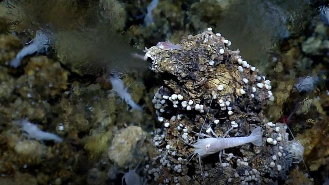
A seafloor vent called a "white smoker" spews mineral-rich water into the ocean and serves as an energy hub for living creatures. Some scientists think life on Earth may have begun around similar vents on the ocean floor billions of years a…

The northeast coast of Hokkaido and Kunashir Island, Japan (44.0N, 143.0E) are seen bordered by drifting sea ice. The sea ice has formed a complex pattern of eddies in response to surface water currents and winds. Photos of this kind aid re…

On July 23, 2013 the deep blue waters of the central North Atlantic Ocean provided a background for a spectacular bloom of phytoplankton. The Moderate Resolution Imaging Spectroradiometer (MODIS) captured this true-color image of the event…

The cloud cover over the Southern Ocean occasionally parts as it did on January 1, 2015 just west of the Drake Passage where the VIIRS instrument on the Suomi NPP satellite glimpsed the above collection of ocean-color delineated eddies whic…

Technicians encapsulated the SWOT satellite, or the Surface Water and Ocean Topography mission, in its payload fairing on Dec. 8, 2022, in preparation for launch. At the SpaceX processing facility at Vandenberg Space Force Base in Californi…

This illustration depicts the Surface Water and Ocean Topography satellite, a mission led by NASA and the French space agency Centre National d'Études Spatiales (CNES). The scientific heart of the SWOT satellite is the Ka-band Radar Interfe…

KENNEDY SPACE CENTER, FLA. - These pristine sand dunes near the launch pads at KSC are gently washed by the calm blue Atlantic Ocean. The beach is part of the Canaveral National Seashore, managed by the National Wildlife Service.

This illustration depicts the Surface Water and Ocean Topography (SWOT) satellite with solar arrays fully deployed. Arranged on opposite sides of the spacecraft bus, the two arrays will remain pointed at the Sun via small motors to provide…

This illustration depicts the Surface Water and Ocean Topography (SWOT) satellite with solar arrays fully deployed. Measuring 48.8 feet (14.9 meters) in length with an area of 335 square feet (31 square meters), the two arrays will remain p…

On June 27, 2021, teams from NASA's Jet Propulsion Laboratory in Southern California and the March Air Reserve Base in Riverside County, California, loaded the scientific heart of the Surface Water and Ocean Topography (SWOT) mission into a…

In this aerial view, a glacier along Greenland's craggy coastline is actively undergoing undercutting, a process in which meltwater flowing out from the bottom of the glacier enters the fjord. The brown water in front of the glacier is caus…

The southern half of the island of Okinawa, Japan (26.5N, 128.0E) can be seen in this nearly cloud free view. Okinawa is part of the Ryuku Islands which extend from Taiwan northeastward to Kyushu, southernmost of the Japanese Home Islands.…

The city of Sapporo on the northernmost of the Japanese Home Island of Hokkaido (43.5N, 141.5E), host to the 1986 Winter Olympic Games is situated along the margin of a large valley which extends across the island from the Sea of Japan to t…

STS045-78-016 (24 March-2 April 1992) --- This view is of the Bahamas and Florida looking westward into the sunglint. The Bahama Banks are in the foreground; from left to right, Andros Island, the Berry Islands, and Grand Bahama Island are…

STS054-95-042 (13-19 Jan 1993) --- The Equatorial Pacific Ocean is represented in this 70mm view. The international oceanographic research community is presently conducting a program called Joint Global Ocean Flux Study (JGOFS) to study th…

STS040-614-047 (5-14 June 1991) --- This image is of the Norfolk, Virginia -- Southern Delmarva Peninsula Southern Chesapeake Bay Area as seen in sunlight. The exposure is adjusted to emphasize the water patterns present. The outgoing ti…
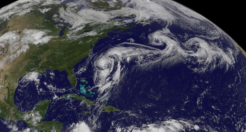
Hurricane Cristobal is located west of Bermuda still holding to hurricane strength with a small window of opportunity for strengthening further before it moves to higher latitudes and over cooler waters in a couple of days. Currently, the s…

This image shows ocean surface currents around the world during the period from June 2005 through Decmeber 2007. <b>Go here to view a video of this data: <a href="http://www.flickr.com/photos/gsfc/7009056027/">www.flickr.com/photos/gsfc/7…

In the midst of a cold snap that sent temperatures 20–40°F (11–22°C) below normal across much of the United States, the Moderate Resolution Imaging Spectroradiometer (MODIS) on the Terra satellite captured this image of cloud streets over t…

These images show the mass Greenland's Jakobshavn Glacier has gained from 2016-17, 2017-18 and 2018-19. Areas with the most growth — about 33 yards (30 meters) — are shown in dark blue. Red areas represent thinning. The images were produced…

KENNEDY SPACE CENTER, FLA. - These pristine sand dunes near the launch pads at KSC are gently washed by the calm blue Atlantic Ocean. Sea oats stand like sentinels on the dunes, which are part of the Canaveral National Seashore, managed by…

iss071e456772 (July 18, 2024) --- The Moon's glint beams off the Pacific Ocean as stars glitter in the background above the Earth's airglow. The Moon is obscured behind a solar array in this photograph from the International Space Station a…

Workers in a clean room in Cannes, France, load the Surface Water and Ocean Topography (SWOT) satellite into a container in preparation for shipping the spacecraft to the U.S. SWOT is an international mission led by NASA and the French spac…

Part of the Surface Water and Ocean Topography (SWOT) satellite's science instrument payload sits in a clean room at NASA's Jet Propulsion Laboratory during assembly. Once fully assembled and launched into orbit, the SUV-size spacecraft wi…

iss071e457356 (July 18, 2024) --- The Moon illuminates a cloud-covered Pacific Ocean as stars glitter in the background above the Earth's airglow. The International Space Station's solar arrays dominate the foreground as the orbital outpost…

NASA's Oceans Melting Greenland airborne mission found that most of Greenland's glaciers that empty into the ocean are at greater risk of rapid ice loss than previously understood. OMG's six-year field campaign studied the ocean's role in g…

The international Surface Water and Ocean Topography (SWOT) satellite is shown in orbit over Earth in this illustration, with sunlight glinting off one of its solar arrays and both antennas of its Ka-band Radar Interferometer (KaRIn) instru…

STS026-43-082 (29 Sept. - 3 Oct. 1988) --- This 70mm northerly oriented frame over the Pacific Ocean features the Hawaiian Islands chain. The islands perturb the prevailing northeasterly winds producing extensive cloud wakes in the lee of t…

STS054-86-001 (13-19 Jan. 1993) --- This 70mm view shows a spectacular multiple spit on the coast of Brazil, about halfway between Rio de Janeiro and the mouth of the Amazon River. Over a few thousand years, according to NASA scientists, sh…

The arculate fronts of these apparently converging internal waves off the northeast coast of Somalia (11.5N, 51.5E) probably were produced by interaction with two parallel submarine canyons off the Horn of Africa. Internal waves are packets…