
The southern half of the island of Okinawa, Japan (26.5N, 128.0E) can be seen in this nearly cloud free view. Okinawa is part of the Ryuku Islands which extend from Taiwan northeastward to Kyushu, southernmost of the Japanese Home Islands.…

Tenarife Island is one of the most volcanically active of the Canary Island archipelago, Atlantic Ocean, just off the NW coast of Africa, (28.5N, 16.5W). The old central caldera, nearly filled in by successive volcanic activity culminating…

The island of Java (8.0S, 112.0E), perhaps better than any other, illustrates the volcanic origin of Pacific Island groups. Seen in this single view are at least a dozen once active volcano craters. Alignment of the craters even defines the…

STS054-74-049 (13-19 Jan. 1993) --- St. Croix is the largest, and most industrial of the U.S. Virgin Islands. This photograph captures St. Croix's features in great detail. The large industrial complex in the middle of the southern shore…
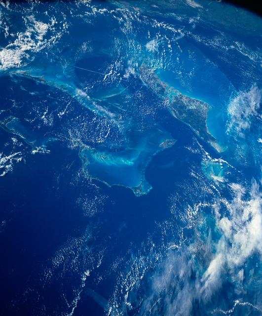
STS054-152-102 (13-19 Jan. 1993) --- This is a south-looking, wide angle view of the northern Bahamas, featuring the islands (from mid-foreground toward background) of Eleuthera, New Providence, and Andros. The northern shore of Cuba can b…

STS007-05-245 (18-24 June 1983) --- A rare view of internal waves in the South China Sea. Several different series of internal waves are represented in the 70mm frame, exposed with a handheld camera by members of the STS-7 astronaut crew…

STS006-45-097 (4-9 April 1983) --- This photograph was taken with a handheld 70mm camera aimed through the “ceiling” windows of the Earth-orbiting space shuttle Challenger during its five-day STS-6 mission. A beautiful photo shows the contr…
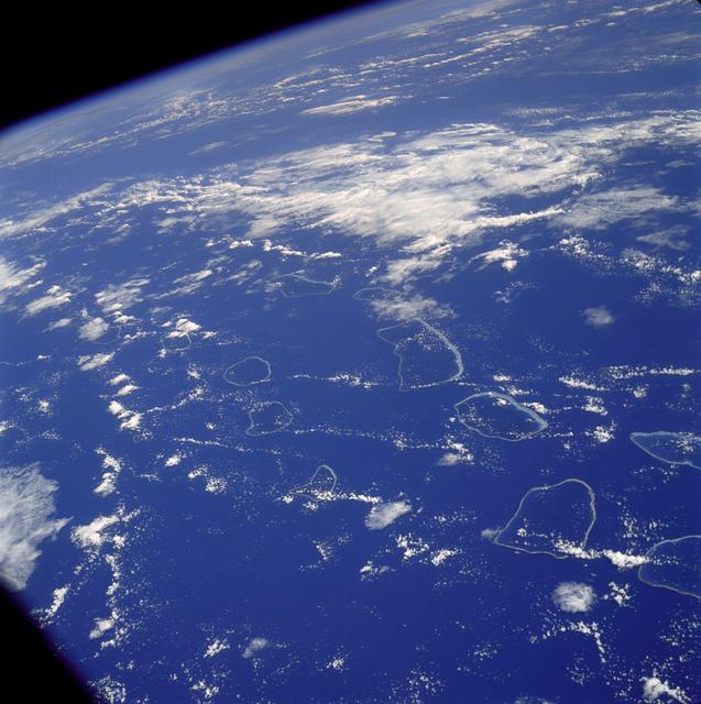
AS07-04-1590 (20 Oct. 1968) --- Tuamotu Archipelago in the South Pacific Ocean, looking southwest, as photographed from the Apollo 7 spacecraft during its 141st revolution of Earth. The photograph was taken from an altitude of 110 nautical…

iss074e0100627 (Dec. 29, 2025) --- A SpaceX Dragon spacecraft is pictured docked to the International Space Station as the orbital outpost soared 269 miles above the Atlantic Ocean northwest of the South Georgia and the South Sandwich Islan…

STS001-13-442 (14 April 1981) --- This photograph showing much of Italy was taken with a handheld 70mm camera from 276 kilometers above Earth as the NASA space shuttle Columbia and its crew were marking their last few hours in space on the…

General Atomics' remotely-operated Altair soars over Rogers Dry Lake at Edwards Air Force Base during a NOAA/NASA earth science mission in November 2005.

iss074e0300237 (Feb. 2, 2026) --- The wintry landscape from New Jersey to Massachusetts is seen from the International Space Station as it orbited 262 miles above the northeastern United States. Temperatures in New York City (lower left) ra…
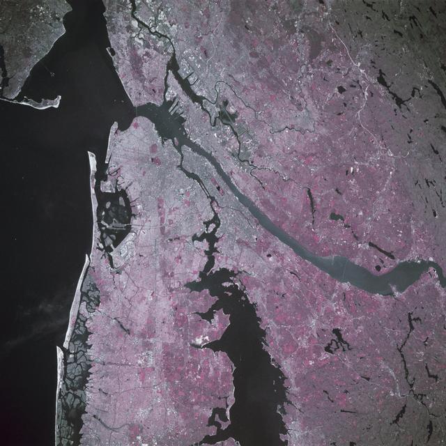
STS039-88-054 (28 April-6 May 1991) --- The dense urban development of the New York City metropolitan area in downstate New York, Long Island and New Jersey shows up as gray and white on this color Infrared photograph. The scene was taken o…
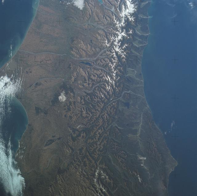
SL4-137-3700 (22 Dec. 1973) --- A near vertical view of a portion of South Island, New Zealand, as see from the Skylab space station in Earth orbit. This picture was taken by one of the Skylab 4 crew members with a handheld 70mm Hasselblad…

Artemis II NASA astronaut Reid Wiseman, commander, and Victor Glover, pilot, are seen after being flown from USS John P. Murtha to Naval Air Station North Island on Navy MH-60 Seahawks from Helicopter Sea Combat Squadron (HSC) 23, Saturday,…

iss074e0209280 (Jan. 28, 2026) --- The wintry landscape from Delaware to Rhode Island is seen from the International Space Station as it orbited 259 miles above the Atlantic coast of the United States. Temperatures in New York City ranged f…

STS026-43-082 (29 Sept. - 3 Oct. 1988) --- This 70mm northerly oriented frame over the Pacific Ocean features the Hawaiian Islands chain. The islands perturb the prevailing northeasterly winds producing extensive cloud wakes in the lee of t…

This distant view of Mt. Fuji, on the main home island of Honshu, Japan (34.0N, 139.0E) was taken from about 450 miles to the south. Evan at that great distance, the majestic and inspiring Mt. Fuji is still plainly visible and easily recogn…

The entire Hawaiian Island Archipelago (21.5N, 158.0W) is seen in this single view. The islands are a favorite international resort and tourist attraction drawing visitors from all over the world to enjoy the tropical climate, year round be…

STS026-038-056 (29 Sept. - 3 Oct. 1988) --- Tambora Caldera, Sumbawa Island, Indonesia as photographed with a 70mm handheld Hasselblad camera. Tambora is a 6-kilometer-wide and 650-meter-deep Caldera formed in 1815 as a result of a huge vol…

This view shows the area around Northeastern Sumatra, Indonesia (1.0N, 104.0E). The city of Singapore and the Singapore Strait is in the center at the southern tip of the Malay Peninsula. The Singapore Strait is the eastern extension of the…

STS049-79-024 (13 May 1992) --- Florida's Atlantic Coast and the Cape Canaveral area form the backdrop for this 70mm scene of Intelsat VI's approach to the Space Shuttle Endeavour. Later, the seven-member crew was successful in capturing t…

SL2-05-364 (22 June 1973) --- Lying in the eastern Mediterranean Sea, the entire Island of Crete (35.0N, 25.0E) can be seen in great detail in this cloud free view. The volcanic origins of this island can also be observed in the many sharp…

SL4-142-4577 (28 Jan. 1974) --- Two large ice islands in the vicinity of South Georgia Island in the South Atlantic Ocean, as photographed from the Skylab space station in Earth orbit by one of the Skylab 4 crewmen. The camera used was a ha…

STS003-10-606 (30 March 1982) --- The entire state of New Jersey (39.5N, 74.5W) is seen in great detail in this photograph. Philadelphia, PA on the west bank of the Delaware River and Camden, NJ on the east bank of this natural boundary, ar…

General Atomics' uninhabited Altair flew a NOAA/NASA coastal mapping, mammal observation and marine monitoring mission off the California coast in late 2005.

General Atomics' uninhabited Altair flew a NOAA/NASA coastal mapping, mammal observation and marine monitoring mission off the California coast in late 2005.

51J-143-126 (5 Oct. 1985) --- The vertical stabilizer of the Earth-orbiting Space Shuttle Atlantis serves to partially frame this scene of Metropolitan Houston. Hold photo with vertical tail at top so that north will be at top. America's fo…

Long regarded as one of the best photo of Houston, Texas (29.5N, 95.0W), this view from space shows the entire greater Houston/Galveston region in remarkable detail and clarity. The dark north/south line in the water between Houston and Gal…

Artemis II NASA astronaut Victor Glover, pilot, is seen after being flown from USS John P. Murtha to Naval Air Station North Island on Navy MH-60 Seahawks from Helicopter Sea Combat Squadron (HSC) 23, Saturday, April 11, 2026, following a s…
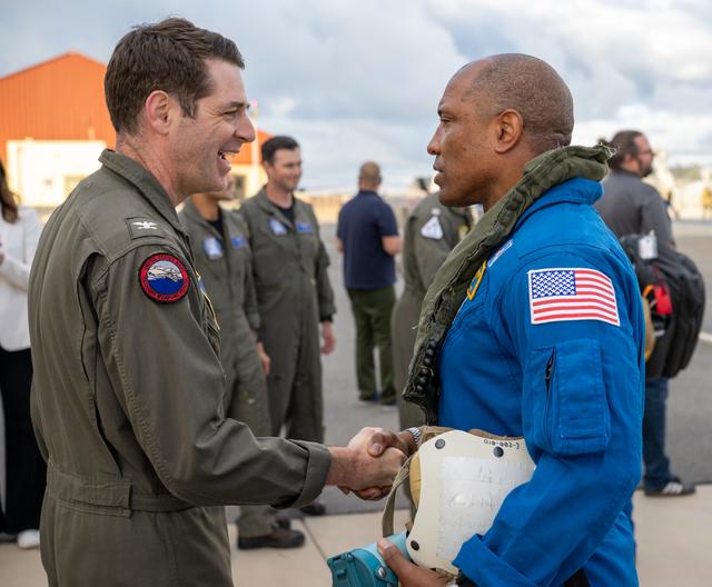
Artemis II NASA astronaut Victor Glover, pilot, greets Capt. Loren “Wookie” Jacobi of Naval Base San Diego after being flown from USS John P. Murtha to Naval Air Station North Island on Navy MH-60 Seahawks from Helicopter Sea Combat Squadr…

This almost totally cloud free, photo of the island of Timor, Indonesia (9.0S, 125.0E) illustrates the volcanic origin of the over 1500 islands of Indonesia. Close examination of the photo reveals several eroded volcanoes on the Island of T…

Cloud vortices off Heard Island, south Indian Ocean. The Moderate Resolution Imaging Spectroradiometer (MODIS) aboard NASA’s Aqua satellite captured this true-color image of sea ice off Heard Island on Nov 2, 2015 at 5:02 AM EST (09:20 UTC…

The northeast coast of Hokkaido and Kunashir Island, Japan (44.0N, 143.0E) are seen bordered by drifting sea ice. The sea ice has formed a complex pattern of eddies in response to surface water currents and winds. Photos of this kind aid re…
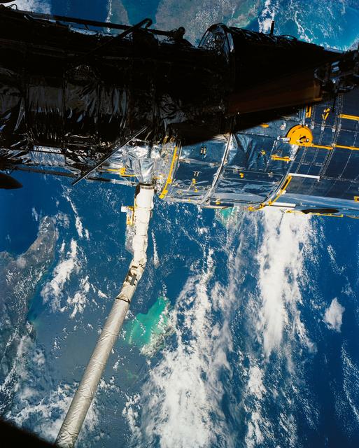
A close up deploy view of the Hubble Space Telescope on the end of the space shuttle remote manipulator system (RMS) with Eastern Cuba, (20.0N, 74.0W) seen on the left side of the telescope and northern Haiti seen on the right side of the t…

The light blue shallow water platforms of the Bahamas, (24.0N, 77.0W) which are separated by very deep dark blue channels make for a striking scene. In the foreground is Andros Island and in the background are the Tongue of the Ocean, the E…

STS033-82-103 (22-27 Nov. 1989) --- This oblique view of the southern half of Madagascar was taken by the crew members of the Space Shuttle Discovery as they orbited Earth at an altitude of 289 nautical miles.

STS040-613-049 (5-14 June 1991) --- This oblique scene from the Earth-orbiting Space Shuttle Columbia shows southern Florida, several of the Bahama Islands and parts of the Atlantic Ocean, the Gulf of Mexico and the Caribbean Sea. The nine…

AST-19-1555 (24 July 1975) --- A sunglint in the South Western Pacific Ocean, as photographed from the Apollo spacecraft in Earth orbit during the joint U.S.-USSR Apollo-Soyuz Test Project mission. The island is Bougainville of the Solomon…
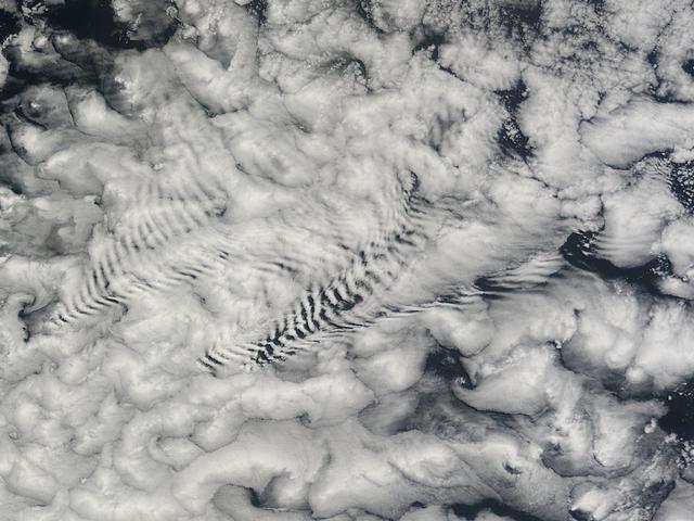
There are special places on Earth that sometimes write their personal signature in the clouds. The Crozet Islands are one such place, thanks to the tall volcanic peaks that grace the islands. When air flows around these tall peaks, it gets…

STS030-152-066 (4-8 May 1989) --- The upper Texas and Louisiana Gulf Coast area was clearly represented in this large format frame photographed by the astronaut crew of the Earth-orbiting Space Shuttle Atlantis. The area covered stretches a…

General Atomics' uninhabited Altair flew a NOAA/NASA coastal mapping, mammal observation and marine monitoring mission off the California coast in late 2005.

STS046-80-009 (31 July-8 Aug. 1992) --- A view of the mouth of the Amazon River and the Amazon Delta shows a large sediment plume expanding outward into the Atlantic Ocean. The sediment plume can be seen hugging the coast north of the Delta…

This unique photo offers a view of the Florida peninsula, western Bahamas, north central Cuba and the deep blue waters of the Gulf Stream, that hugs the east coast of Florida (27.0N, 82.0W). In addition to being an excellent photograph for…

Navy MH-60 Seahawks from Helicopter Sea Combat Squadron (HSC) 23 are seen as they arrive at Naval Air Station North Island, Calif. after flying from USS John P. Murtha with Artemis II NASA astronauts Reid Wiseman, commander; Victor Glover,…

Navy MH-60 Seahawks from Helicopter Sea Combat Squadron (HSC) 23 are seen as they arrive at Naval Air Station North Island, Calif. after flying from USS John P. Murtha with Artemis II NASA astronauts Reid Wiseman, commander; Victor Glover,…

Artemis II NASA astronaut Christina Koch, mission specialist, and CSA (Canadian Space Agency) astronaut Jeremy Hansen, greet NASA team members after being flown from USS John P. Murtha to Naval Air Station North Island on Navy MH-60 Seahawk…

Artemis II NASA astronaut Christina Koch, mission specialist, right, joined by Tarah Castleberry, flight surgeon, left, is seen after being flown from USS John P. Murtha to Naval Air Station North Island on Navy MH-60 Seahawks from Helicopt…