This colorful view of Mercury was produced by using images from the color base map imaging campaign during MESSENGER's primary mission. These colors are not what Mercury would look like to the human eye, but rather the colors enhance the ch…
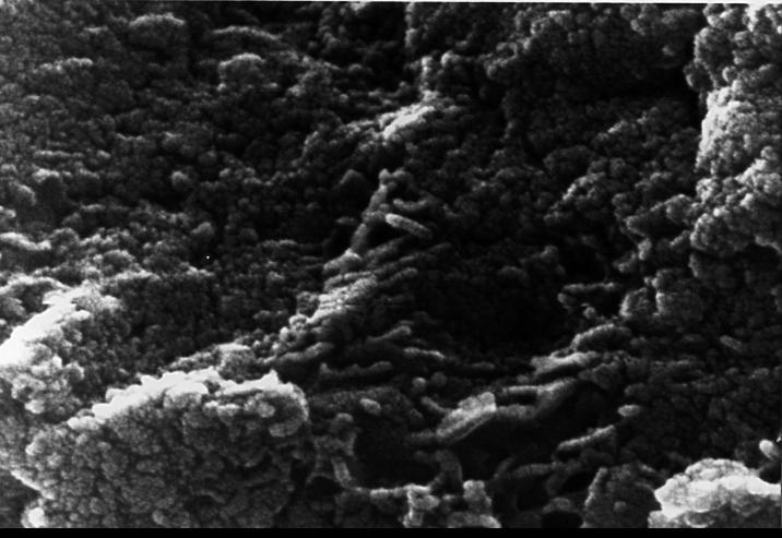
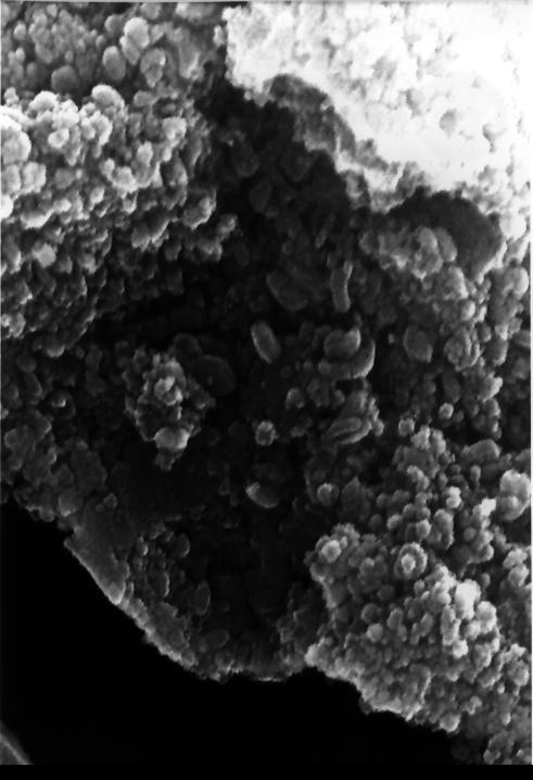
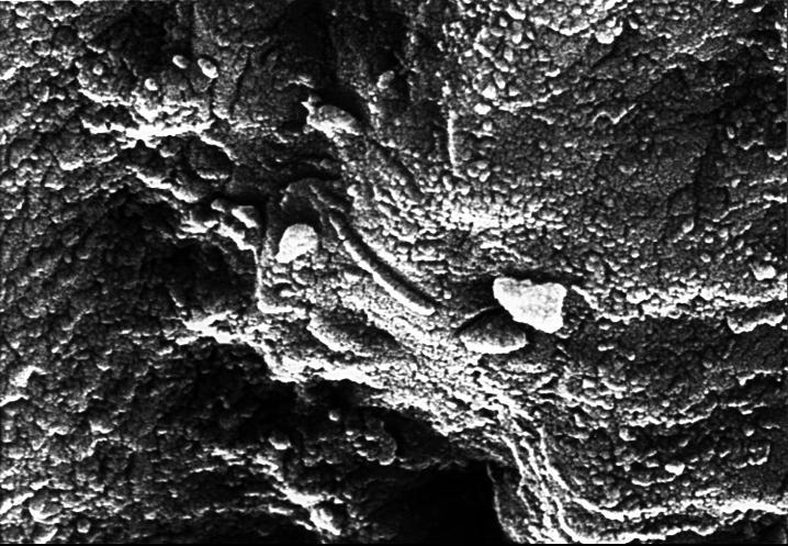
This electron microscope image shows tubular structures of likely Martian origin. These structures are very similar in size and shape to extremely tiny microfossils found in some Earth rocks. http://photojournal.jpl.nasa.gov/catalog/PIA002…
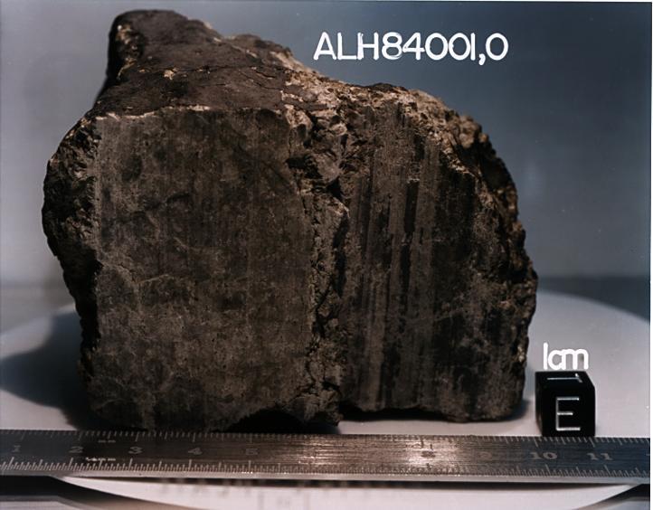
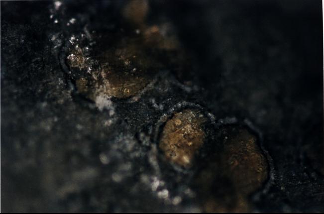
This 4.5 billion-year-old rock, labeled meteorite ALH84001, is one of 10 rocks from Mars in which researchers have found organic carbon compounds that originated on Mars without involvement of life. http://photojournal.jpl.nasa.gov/catalog…
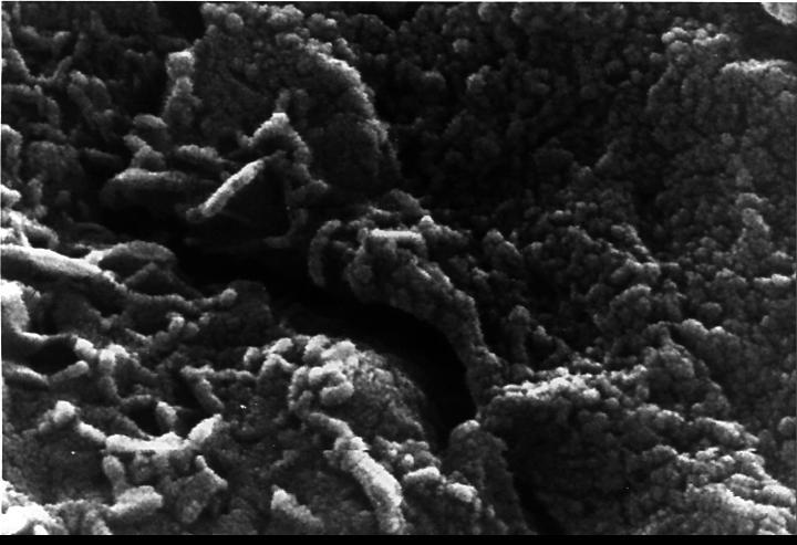
This electron microscope image shows extremely tiny tubular structures that are possible microscopic fossils of bacteria-like organisms that may have lived on Mars more than 3.6 billion years ago. http://photojournal.jpl.nasa.gov/catalog/P…
NASA, Roscosmos, and Russian Search and Recovery Forces meet at the Cosmonaut Hotel in Karaganda, Kazakhstan to discuss the readiness for the landing of Expedition 66 crew members Mark Vande Hei of NASA, and Pyotr Dubrov, and Anton Shkapler…
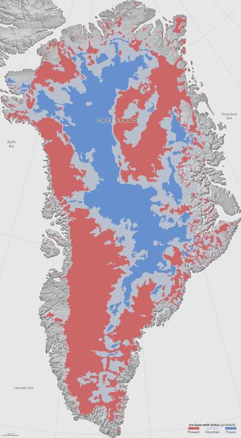
NASA researchers have helped produce the first map showing what parts of the bottom of the massive Greenland Ice Sheet are thawed – key information in better predicting how the ice sheet will react to a warming climate. Greenland’s thick i…
The Advanced Rapid Imaging and Analysis (ARIA) team at NASA's Jet Propulsion Laboratory created this Damage Proxy Map (DPM) of Tongatapu, the main island of Tonga, following the landfall of Cyclone Gita, a Category 4 storm that hit Tonga on…
Sara Ann Wylie of Public Lab shows the do to yourself Balloon Mapping Kit, during the first ever White House Maker Faire, which brings together students, entrepreneurs, and everyday citizens who are using new tools and techniques to launch…
S72-01718 (July 1972) --- A photographic illustration of a full moon showing the location of the Apollo 17 landing site on the lunar nearside. The black dot pinpointing the landing site is in the Taurus-Littrow area at the southeastern edge…
S71-44150 (February 1971) --- A vertical view of the Apollo 16 landing site located in the Descartes area on the lunar nearside. The overlay indicates the location of the proposed touchdown point for the Apollo 16 Lunar Module (LM). Descart…
Technicians remove the protective casing covering NASA’s Carruthers Geocorona Observatory on Monday, July 21, 2025, at the Astrotech Space Operations Facility near the agency’s Kennedy Space Center in Florida. The Carruthers Geocorona Obser…
Maryland School for the Blind students Andrea Washington, left, and Derontay Taylor, right, along with science teacher Colleen Shovestull, center, use their sense of touch on topographical maps to learn about the Moon during a visit to NASA…
Technicians remove the protective casing covering NASA’s Carruthers Geocorona Observatory on Monday, July 21, 2025, at the Astrotech Space Operations Facility near the agency’s Kennedy Space Center in Florida. The Carruthers Geocorona Obser…
Maryland School for the Blind students Andrea Washington, left, and Derontay Taylor, right, along with science teacher Colleen Shovestull, center, use their sense of touch on topographical maps to learn about the Moon during a visit to NASA…
This still image features a free-air gravity map of the Moon's southern latitudes developed by S. Goossens et al. from data returned by the Gravity Recovery and Interior Laboratory (GRAIL) mission. If the Moon were a perfectly smooth sphe…
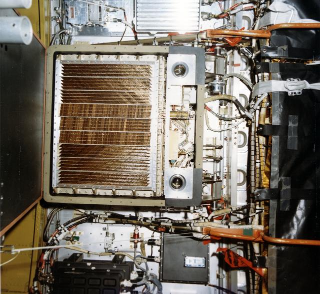
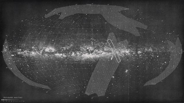
This photograph shows Skylab's Galactic X-Ray Mapping facility (S150), an astrophysics and space sciences investigation. An objective of this experiment was to extend the search for the origin of galactic x-rays beyond the sensitivity possi…
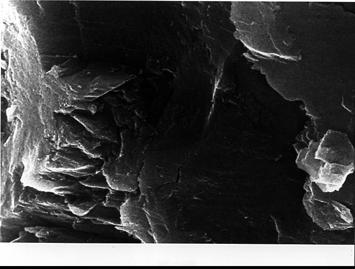
In the center of this electron microscope image of a small chip from a meteorite are several tiny structures that are possible microscopic fossils of primitive, bacteria-like organisms that may have lived on Mars more than 3.6 billion years…
Some 290 million years ago, a star much like the sun wandered too close to the central black hole of its galaxy. Intense tides tore the star apart, which produced an eruption of optical, ultraviolet and X-ray light that first reached Earth…
A map of the Moon on a black background for October 12, 2013 at 12:00 UT. Labeled features include maria, craters, a mountain range, a scarp, a rille, and four Apollo landing sites. Credit: NASA's Goddard Space Flight Center Scientific Vis…
Topography of Earth's moon generated from data collected by the Lunar Orbiter Laser Altimeter, aboard NASA's Lunar Reconnaissance Orbiter, with the gravity anomalies bordering the Procellarum region superimposed in blue. The border structur…
This image shows the Milky Way as seen from the solar system. The shaded regions are those scanned by the Skylab experiment Galactic X-Ray Mapping (S150). The galactic center is approximately at the center of the map. The three overlapping…
On July 10, 2011, Melinda Webster of University of Washington mapped the locations where measurements were collected during the 2011 ICESCAPE mission's fourth sea ice station in the Chukchi Sea. The ICESCAPE mission, or "Impacts of Cl…
NASA image acquired April 18 - October 23, 2012 This new image of the Earth at night is a composite assembled from data acquired by the Suomi National Polar-orbiting Partnership (Suomi NPP) satellite over nine days in April 2012 and thirte…
This image of the northwestern portion of Mars' Gale Crater and terrain north of it, from the European Space Agency's Mars Express orbiter, provides a locator map for some features visible in an October 2017 panorama from NASA's Curiosity M…
NASA, ESA, Roscosmos, and Russian Search and Recovery Forces meet at the Cosmonaut Hotel in Karaganda, Kazakhstan to discuss the readiness for the landing of Expedition 57 crew members Serena Auñón-Chancellor of NASA, Alexander Gerst of ESA…
This lunar map shows the traverse plans for the Apollo 14 lunar landing mission. Areas marked include Lunar module landing site, areas for the Apollo Lunar Surface Experiment Package (ALSEP) and areas for gathering of core samples.
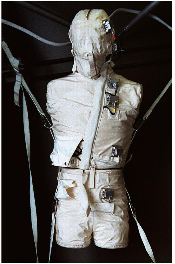
The Phantom Torso is a tissue-muscle plastic anatomical model of a torso and head. It contains over 350 radiation measuring devices to calculate the radiation that penetrates internal organs in space travel. The Phantom Torso is one of thre…
The hands of Maryland School for the Blind student Andrea Washington, are guided across a topographical map of the Solar System by science teacher Colleen Shovestull during a visit to NASA Headquarters in Washington, Thursday, Oct. 29, 2009…
Artists used paintbrushes and airbrushes to recreate the lunar surface on each of the four models comprising the LOLA simulator. Project LOLA or Lunar Orbit and Landing Approach was a simulator built at Langley to study problems related to…
Technicians remove the protective casing covering NASA’s Carruthers Geocorona Observatory on Monday, July 21, 2025, at the Astrotech Space Operations Facility near the agency’s Kennedy Space Center in Florida. The Carruthers Geocorona Obser…
This photograph shows orange-colored carbonate mineral globules found in a meteorite, called ALH84001, believed to have once been a part of Mars. http://photojournal.jpl.nasa.gov/catalog/PIA00290
This electron microscope image shows egg-shaped structures, some of which may be possible microscopic fossils of Martian origin as discussed by NASA research published in the Aug. 16, 1996. http://photojournal.jpl.nasa.gov/catalog/PIA00286
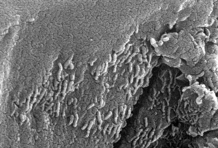
This high-resolution scanning electron microscope image shows an unusual tube-like structural form that is less than 1/100th the width of a human hair in size found in meteorite ALH84001, a meteorite believed to be of Martian origin. http:…
STS059-16-032 (9-20 April 1994) --- Astronaut Kevin P. Chilton, pilot, displays a map of Scandinavia on the Space Shuttle Endeavour's flight deck. Large scale maps such as this were used by the crew to locate specific sites of interest to…
NASA, Roscosmos, and Russian Search and Recovery Forces meet at the Cosmonaut Hotel in Karaganda, Kazakhstan, Sunday, Dec. 7, 2025, to discuss the readiness for the landing of Expedition 73 NASA astronaut Jonny Kim, and Roscosmos cosmonauts…
This is an image of equatorial Africa, centered on the equator at longitude 15degrees east. This image is a mosaic of almost 4,000 separate images obtained in 1996 by the L-band imaging radar onboard the Japanese Earth Resources Satellite.…
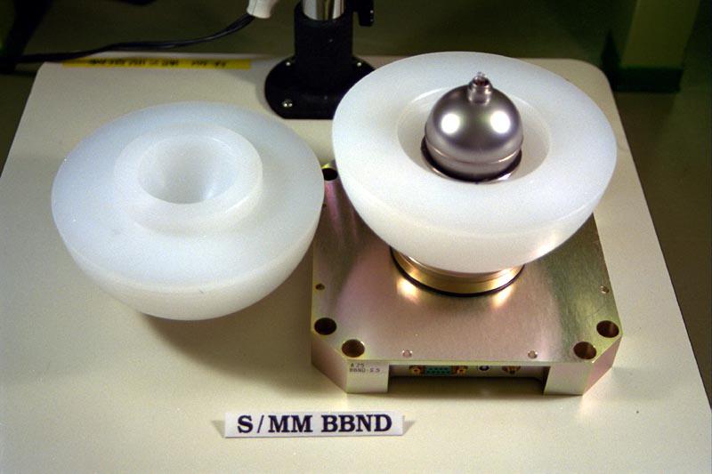
The Bonner Ball Neutron Detector measures neutron radiation. Neutrons are uncharged atomic particles that have the ability to penetrate living tissues, harming human beings in space. The Bonner Ball Neutron Detector is one of three radiatio…
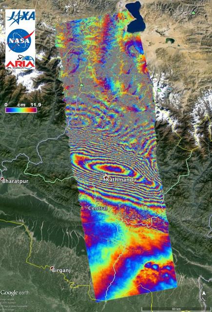
NASA and its partners are contributing important observations and expertise to the ongoing response to the April 25, 2015, magnitude 7.8 Gorkha earthquake in Nepal. The quake was the strongest to occur in that area since the 1934 Nepal-Biha…
AS14-64-9089 (5-6 Feb. 1971) --- Astronaut Edgar D. Mitchell, lunar module pilot, moves across the lunar surface as he looks over a traverse map during an extravehicular activity (EVA). Lunar dust can be seen clinging to the boots and legs…
The hands of Maryland School for the Blind student Andrea Washington and science teacher Colleen Shovestull use their sense of touch on a topographical map of the solar system during a visit to NASA Headquarters in Washington, Thursday, Oct…
If the Moon were a perfectly smooth sphere of uniform density, the gravity map would be a single, featureless color, indicating that the force of gravity at a given elevation was the same everywhere. But like other rocky bodies in the solar…
S72-01716 (July 1972) --- An oblique view of the Taurus-Littrow area on the lunar nearside, as photographed from the Apollo 15 spacecraft in lunar orbit. This is an enlarged view. The "X" marks the landing site of the scheduled Apollo 17 lu…
The fingers of a student from the Maryland School for the Blind touches on a topographical map to learn about the surface of the Moon during a visit to NASA Headquarters in Washington, Thursday, Oct. 29, 2009. Seven students from the Maryl…
S72-03145 (October 1972) --- A vertical view of the Apollo 17 Taurus-Littrow site with an overlay to illustrate the three planned Apollo 17 traverses using the Lunar Roving Vehicle (LRV). The EVA-1 traverse has a single station (1); the EVA…
Technicians remove the protective casing covering NASA’s Carruthers Geocorona Observatory on Monday, July 21, 2025, at the Astrotech Space Operations Facility near the agency’s Kennedy Space Center in Florida. The Carruthers Geocorona Obser…
S71-33432 (1 July 1971) --- These alternative traverses can be carried out on foot. They will be used if the Lunar Roving Vehicle (LRV) becomes inoperative. This artist's concept showing part of the Hadley Rille and several of the Apennine…