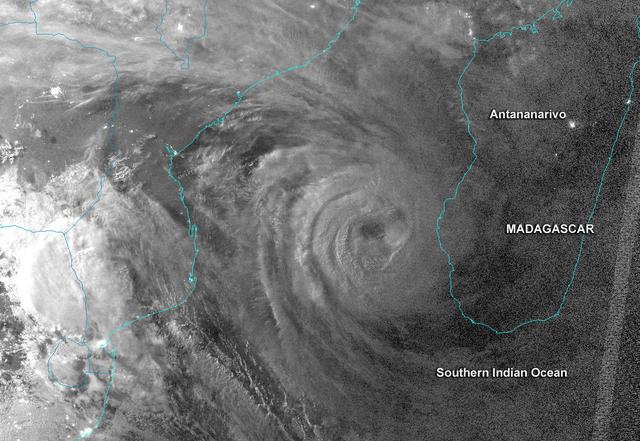
This night-time image revealed Cyclone Haruna's massive eye before it made landfall in southwestern Madagascar.  This image was taken from the VIIRS instrument that flies aboard the NASA-NOAA Suomi NPP satellite. The image was taken on Feb.…
NASA-NOAA's Suomi NPP Satellite Cyclone Haruna Near Madagascar at Night
STS007-03-058 (18-24 June 1983) ---  The Island of Madagascar in the Indian Ocean off the coast of Africa.  The colorful area is the mouth of the Betsiboka River near the city of Majunga.  The photograph was taken with a 70mm handheld camer…
Betsiboka River Valley, Madagascar
AS17-148-22717 (7 Dec. 1972) --- This view of a portion of Earth was taken from the Apollo 17 spacecraft following trans-lunar insertion during the final lunar landing mission in NASA's Apollo Program. The visible land mass is the southern…
View of Africa and Madagascar from the Apollo 17 spacecraft
Mangoro River on Madagascar's east coast leads to the Indian Ocean in this photograph from the Indian Ocean as it orbited 263 miles above
Mangoro River on Madagascar's east coast leads to the Indian Ocean
This high oblique view shows the majority of the island of Madagascar (19.0S, 47.5E). This Texas sized island is now largely deforested and is suffering from severe soil erosion as well as a declining biological species diversity and produc…
Deforestation, Madagascar
iss071e361950 (July 15, 2024) --- The International Space Station's 57.7-foot-long Canadarm2 robotic arm crosses the foreground as the orbital outpost soared 265 miles above the Mozambique Channel south of the African island nation of Madag…
The Canadarm2 robotic arm above the Mozambique Channel
iss071e345427 (July 15, 2024) --- The Mayotte archipelago, a French overseas department and region, in the Mozambique Channel and in between Madagascar and Mozambique is pictured from the International Space Station as it orbited 263 miles…
The Mayotte archipelago, a French overseas department and region
STS033-82-103 (22-27 Nov. 1989) --- This oblique view of the southern half of Madagascar was taken by the crew members of the Space Shuttle Discovery as they orbited Earth at an altitude of 289 nautical miles.
Deforestation, Madagascar
No more images