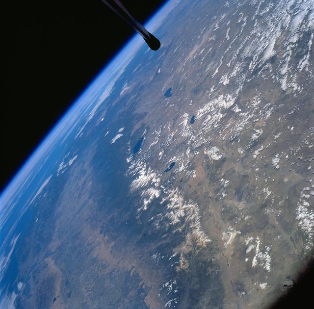
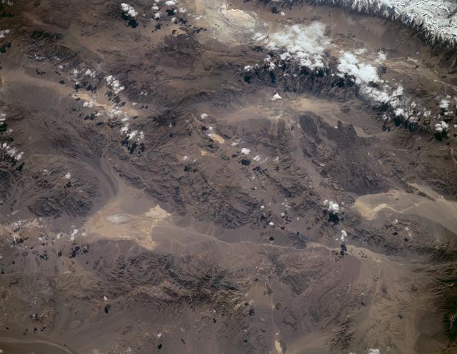
STS059-228-094 (9-20 April 1994) --- The spring thaw along the coast of the Gulf of Alaska has not touched the St. Elias Mountains, southeast of Yakutat Bay and Malaspina Glacier.  A prominent glacier flows from Mt. Fairweather (15,300 feet…
Earth observations taken during the STS-59 mission
STS061-106-091 (December 1993) --- The entire southern tip of Africa is shown in this high altitude 50mm photograph.  The center of the photograph is at approximately 28.0 degrees south and 24.0 degrees east Cape Columbine is at the upper r…
Southern Africa as seen from STS-61 Shuttle Endeavour
AS09-23-3566 (3-13 March 1969) --- Near vertical view of the Birmingham, Alabama area extending to Gadeden, as photographed from the Apollo 9 spacecraft during its Earth-orbital mission. The city spreads out between ridges of the folded sou…
Near vertical view of Birmingham, Alabama as seen from Apollo 9
STS058-78-021 (18 Oct-1 Nov 1993) --- A clear three-dimensional view of the Karakorum Range.  This northwestern extension of the Himalaya contains glaciated peaks having elevations of 7,000 to 8,000 meters.
Pakistan as seen from STS-58
AS09-20-3137 (3-13 March 1969) --- The Grand Canyon is sharply etched on the snow-covered Colorado Plateau in Arizona in this photograph from the Apollo 9 spacecraft during its Earth-orbital mission. Lake Powell behind Glen Canyon Dam is in…
Grand Canyon in Colorado Plateau in Arizona as seen from Apollo 9
STS058-88-017 (18 Oct-1 Nov 1993) --- The eye-catching "bullseye" of the Richat Structure adds interest to the barren Gres de Chinguetti Plateau in central Mauretania, northwest Africa.  It represents domally uplifted, layered (sedimentary)…
Earth observations during STS-58
STS058-77-083 (18 Oct-1 Nov 1993) --- In this scene of the south coast of Africa, Cape Agulhas, the southernmost point on the continent, appears as the leftmost cape.  Viewed with the Earth's limb top left, clouds at bottom, the view direct…
Cape Province, South Africa as seen from STS-58
STS059-154-160 (9-20 April 1994) --- Orient with Mono Lake, California at the lower right; then the view is westward across the Sierra Nevada into the San Joaquin River drainage.  A tiny network of ski trails can be seen on the Mono Lake si…
Mono Lake, California as seen from STS-59
SL3-22-0214 (July-September 1973) --- A vertical view of southeastern Washington State as photographed from Earth orbit by one of the six lenses of the Itek-furnished S190-A Multispectral Photographic Facility Experiment aboard the Skylab s…
View of southeastern Washington State
SL3-27-180 (July-September 1973) --- A vertical view of the Snowy Mountains area of Australian Alps in the States of Victoria and New South Wales, Australia, as photographed from Earth orbit by one of the six lenses of the Itek-furnished S1…
View of Snowy Mountains area of Australian Alps as photographed from Skylab
SL4-93-153 (February 1974) --- A vertical view of the Birmingham and central Alabama area is seen in this Skylab 4 Earth Resources Experiments Package S190-B (five-inch earth terrain camera) infrared photographed taken from the Skylab space…
Birmingham and central Alabama area seen in Earth Resources Exp. Package
AST-02-130 (20 July 1975) --- An oblique view of a portion of Libya and the Arab Republic of Egypt, as photographed from the Apollo spacecraft in Earth orbit during the joint U.S.-USSR Apollo-Soyuz Test Project mission. The geological featu…
View of portion of Libya and Arab Republic of Egypt
AST-30-2601 (20 July 1975) --- An area of the Cascade Mountains southeast of Seattle in the State of Washington, as photographed from the Apollo spacecraft in Earth orbit during the joint U.S.-USSR Apollo-Soyuz Test Project mission. The vie…
Area of Cascade Mountains southeast of Seattle in State of Washington
STS058-95-028 (18 Oct-1Nov 1993) --- Lake Urmia (Orumiyeh) in the high desert plateau of northwest Iran dominates the center of this northeast-looking view.  The left edge of the view cuts Lake Van in eastern Turkey.  The Caucasus Mountains…
Kurdistan Region, Asia as seen from STS-58
SL4-138-3843 (1 Jan. 1974) --- A part of northern California centered near San Francisco Bay photographed at 3 p.m. Jan. 2, 1974, from the Skylab space station in Earth orbit. This near vertical view encompasses the coastline from Monterey…
Northern California near San Francisco
AST-19-1570 (24 July 1975) --- An oblique view of the Rocky Mountains area of British Columbia and Alberta in Canada, as photographed from the Apollo spacecraft in Earth orbit during the joint U.S.-USSR Apollo-Soyuz Test Project mission. Th…
View of Rocky Mountains area of British Columbia and Alberta, Canada
STS058-89-013 (18 Oct-1 Nov 1993) --- An oblique westward view, across the wheat fields and cattle pastures, of eastern Colorado to the Front Range of the Rocky Mountains.  Denver is bisected at the center of the right edge of the frame.  P…
Colorado as seen from STS-58
STS058-101-014 (18 Oct-1 Nov 1993) --- The best, most-nearly cloud-free, shuttle view yet of Mount Everest, the highest mountain in the world at 29,028 feet. The peak, on the border between Nepal and China, is almost exactly in the center o…
Mount Everest as seen from STS-58
STS059-220-041 (9-20 April 1994) --- View to the south by southwest across the southern Gobi Desert (China) across the Chi-Lien-Shan or Quilienshan or Nanshan (Mountains) in Gansu Province to Lake Quinghai or Ch'ing-Hai (orthography varies…
Gobi Desert, China as seen from STS-59
STS058-081-038 (18 Oct-1 Nov 1993) --- Fall colors in the northeast were captured by the STS-58 crew members. Long Island and the lower Hudson River dominate this scene, taken on a clear October day at the peak of the colorful fall foliage…
New York and New Jersey as seen from STS-58
S66-54839 (14 Sept. 1966) --- China, India, and Nepal, looking east, as seen from the Gemini-11 spacecraft during its 37th revolution of Earth. The Great Himalaya Mountain Range is clearly visible. Photo credit: NASA
China, India, and Nepal as seen from Gemini 11
SL3-33-156 (July-September 1973) --- A near vertical view of the Florence, Italy area as photographed from Earth orbit by one of the Itek-furnished S190-A Multispectral Photographic Facility Experiment aboard the Skylab space station. The v…
View of Florence, Italy area from Skylab
STS058-085-091 (18 Oct-1 Nov 1993) --- Yellowstone Lake and the surrounding Plateau are centered in this scene of northwestern Wyoming, and adjacent Idaho and Montana. The view extends across the Absaroka Range to Billings, on the Yellowsto…
Yellowstone River and Wyoming as seen from STS-58
AS07-07-1832 (15 Oct. 1968) --- Toba, Kakar, Fort Sandeman, Sulaiman Range area in (West) Pakistan, as seen from the Apollo 7 spacecraft during its 84th revolution of Earth. Note geological features such as folded mountain structures, antic…
Mountain ranges in western Pakistan as seen from the Apollo 7 spacecraft
STS058-72-004 (18 Oct-1 Nov 1993) --- The Sierra Nevada Mountain Range can be seen in this north-looking high oblique view taken in October, 1993, by the STS-58 crew.  Visible in the view to the west of the Sierra Nevada are the San Joaquin…
Sierra Nevada Mountain Range as seen from STS-58
STS059-L09-162 (9-20 April 1994) --- Orient with the snow-covered mountains (Sierra Nevada of California) in the upper right corner.  Then Owens Valley runs along the top of the photograph to Owens Lake playa at top center.  The upper end o…
Sierra Nevada, California as seen from STS-59
AST-16-1132 (20 July 1975) --- A vertical view of the eastern portion of the state of South Australia in Australia, as photographed from the Apollo spacecraft in Earth orbit during the joint U.S.-USSR Apollo-Soyuz Test Project mission. The…
Eastern portion of State of South Australia in Australia
STS058-91-058 (18 Oct-1 Nov 1993) --- In this unusually clear view, the Ouachita Mountains of southeastern Oklahoma are framed on the north by Lake Eufaula on the South Canadian River, and on the south by the Red River.  Sandstone, shale an…
Ouachita Mountains, Oklahoma as seen from STS-58
This view of southern California as seen from the Apollo 7 spacecraft during its 18th revolution of the earth. Photographed from an altitude of 124 nautical miles. The coast of California can be seen from Point Mugu southward to Oceanside.…
Southern California as seen from the Apollo 7 spacecraft
AS7-07-1748 (15 Oct. 1968) --- The world's dozen peaks which reach a height of greater than five miles above sea level are seen in this photograph from the Apollo 7 spacecraft at an altitude of approximately 130 nautical miles. The 29,028 f…
World's mountains over 5 miles above sea level as seen from the Apollo 7
SL4-138-3875 (February 1974) --- A color oblique photograph looking east over the Rocky Mountains and Great Plains. This view covers a portion of the States of Colorado, Wyoming, and Nebraska. A Skylab 4 crewmen took this picture with a han…
View east over the Rocky Mountains and Great Plains
SL3-22-0322 (July-September 1973) --- An oblique view of the Salt Lake City, Utah area as photographed from Earth orbit by one of the six lenses of the Itek-furnished S190-A Multispectral Photographic Facility Experiment aboard the Skylab s…
View of the Salt Lake City, Utah area
SL3-88-004 (July-September 1973) --- A vertical view of the Salinas River Valley area south of Monterey Bay, California area is seen in this Skylab 3 Earth Resources Experiments Package S190-B (five-inch Earth terrain camera) photograph tak…
View of the Salinas River Valley area south of Monterey Bay, California
SL3-45-020 (July-September 1973) --- A vertical view of the Virginia-Tennessee-Kentucky border area as photographed from Earth orbit by one of the six lenses of the Itek-furnished S190-A Multispectral Photographic Facility Experiment aboard…
View of Virginia, Tennessee, Kentucky border area
No more images