iss071e384199 (July 17, 2024) --- The Canadarm2 robotic arm's latching end effector, or LEE, is used to grapple fixtures on the International Space Station, as well as capture the approaching Cygnus cargo craft from Northrop Grumman and att…
The Canadarm2 robotic arm's latching end effector, or LEE
STS057-73-075 (21 June-1 July 1993) --- Eastern Mediterranean  from an unusually high vantage point over the Nile River, this north-looking view shows not only the eastern Mediterranean but also the entire landmass of Asia Minor, with the B…
STS-57 Earth observation of the Eastern Mediterranean, Nile River, Asia Minor
AST-17-1378 (20 July 1975) --- A near vertical view of the most southerly portion of the Island of Sicily in the Mediterranean Sea, as photographed from the Apollo spacecraft in Earth orbit during the joint U.S.-USSR Apollo-Soyuz Test Proje…
View of southerly portion of Island of Sicily
The Nile River Delta of Egypt (30.0N, 31.0E) irrigated by the Nile River and its many distributaries, is some of the richest farm land in the world and home to some 45 million people, over half of Egypt's population. The capital city of Cai…
Nile River Delta, Egypt
SL3-40-077 (July-September 1973) --- A vertical view of the Mediterranean coastal area of southeastern France as photographed from Earth orbit by one of the six lenses of the Itek-furnished S190-A Multispectral Photographic Facility Experim…
View of Mediterranean coastal area of southeastern France
Suez Canal, Gulf of Suez, Sinai Peninsula, United Arab Republic (Egypt), Mediterranean Sea, as seen from the Apollo 7 spacecraft during its 13th revolution of the earth. Photographed from an altitude of 126 nautical miles, at ground elapsed…
Suez Canal, Gulf of Suez, Sinai Peninsula, Egypt, as seen from the Apollo 7
51F-32-024 (29 July - 6 August 1985) --- Italy's “boot heel" surrounded by waters of the Ionian Sea/Golfo di Taranto and the Adriatic Sea is very clearly visible in this scene made with a handheld 70mm camera. Spacelab 2's versatile i…
Southern Italy, Instrument Pointing Subsystem
During STS-56, the Shuttle Pointed Autonomous Research Tool for Astronomy 201 (SPARTAN-201), a freeflying payload, was photographed by Discovery's, Orbiter Vehicle (OV) 103's, crewmembers as it drifted above the Mediterranean Sea near the i…
STS-56 view of freeflying SPARTAN-201 backdropped over the Mediterranean Sea
SL2-05-359 (22 June 1973) --- This rare cloud free view of southern Italy (41.0N, 16.0E) shows almost all of the famous `boot' configuration of the peninsula up to just north of Naples and Mount Vesuvius. The land mass of this historic peni…
Southern Italy
STS040-152-180 (5-24 June 1991) --- The Sinai Peninsula dominates this north-looking, oblique view.  According to NASA photo experts studying the STS 40 imagery, the Red Sea in the foreground is clear of river sediment because of the prevai…
Southeastern Mediterranean Panorama
STS-56 Earth observation of the northeastern Nile Delta was photographed from the Earth-orbiting Discovery, Orbiter Vehicle (OV) 103. The branch of the Nile featured in the frame is Daimietta. The Suez Canal marks the boundary of the Nile D…
STS-56 Earth observation of the northeastern Nile Delta
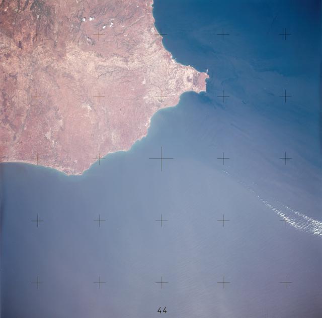
S66-45749 (18 July 1966) --- Straits of Gibraltar, Mediterranean Sea, Spain in background, Algeria and Morocco in foreground as seen from Gemini-10 spacecraft. Photo credit: NASA
Straits of Gibralter, Mediterranean Sea, Spain as seen from Gemini 10
SL2-05-364 (22 June 1973) --- Lying in the eastern Mediterranean Sea, the entire Island of Crete (35.0N, 25.0E) can be seen in great detail in this cloud free view. The volcanic origins of this island can also be observed in the many sharp…
Entire Island of Crete
AST-16-1268 (20 July 1975) --- A near vertical view of a portion of the Mediterranean coast of Turkey and Syria, as photographed from the Apollo spacecraft in Earth orbit during the joint U.S-USSR Apollo-Soyuz Test Project mission. This vie…
View of portion of Mediterranean Coast of Turkey and Syria
iss071e414023 (Aug. 2, 2024) --- The sun's glint beams off the Gulf of Gabes on the coast of Tunisia with Sharqi Island in the Mediterranean Sea in this photograph taken from the International Space Station as it orbited 262 miles above the…
The sun's glint beams off the Gulf of Gabes
STS001-13-442 (14 April 1981) --- This photograph showing much of Italy was taken with a handheld 70mm camera from 276 kilometers above Earth as the NASA space shuttle Columbia and its crew were marking their last few hours in space on the…
Bay of Naples, Italy
STS-56 Earth observation taken aboard Discovery, Orbiter Vehicle (OV) 103, is of the Strait of Gibraltar. A small bank of clouds marks the passage between Spain and Morocco at the western edge of the Mediterranean Sea. This passage, one of…
STS-56 Earth observation of the Strait of Gibraltar
41G-120-082 (5-13 Oct.  1984) --- This High oblique view was photographed with a medium format camera aboard the Earth-orbiting space shuttle Challenger. It features the Strait of Gibraltar and the Mediterranean Sea. Unlike vertical photogr…
Strait of Gibraltar
No more images