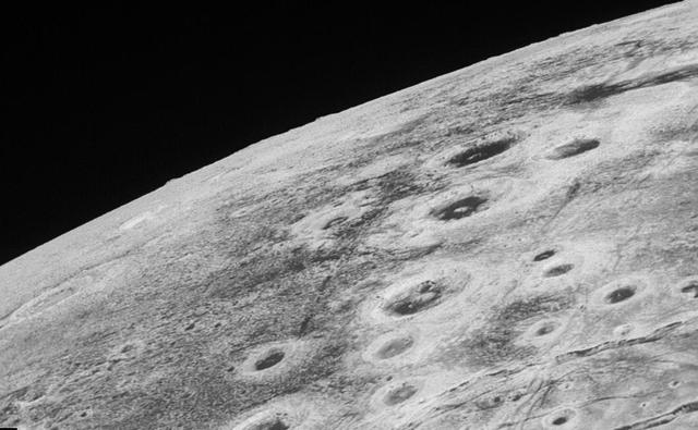
This high-resolution swat of Pluto sweeps over the cratered plains at the west of the New Horizons' encounter hemisphere and across numerous prominent faults, skimming the eastern margin of the dark, forbidding region informally known as Ct…

This image of Pluto from NASA's New Horizons spacecraft, processed in two different ways, shows how Pluto's bright, high-altitude atmospheric haze produces a twilight that softly illuminates the surface before sunrise and after sunset, allo…

This is a frame from the first movie created by New Horizons to reveal color surface features of Pluto and its largest moon, Charon. "It's a bit unusual to see so much surface detail at this distance," said New Horizons co-investigator Will…
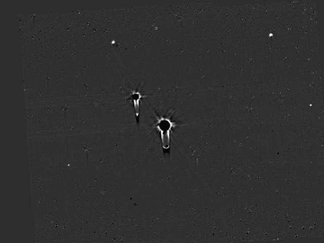
This single frame from a four-frame movie shows New Horizons' final deep search for hazardous material around Pluto, obtained on July 1, 2015. These data allow a highly sensitive search for any new moons. The images were taken with the spac…

These images, taken by NASA's New Horizons' Long Range Reconnaissance Imager (LORRI), show numerous large-scale features on Pluto's surface. The distance to Pluto ranges from 47 million kilometers (about 29 million miles) on June 5 to 31 mi…

In the center of this 300-mile (470-kilometer) wide image of Pluto from NASA's New Horizons spacecraft is a large region of jumbled, broken terrain on the northwestern edge of the vast, icy plain informally called Sputnik Planum, to the rig…
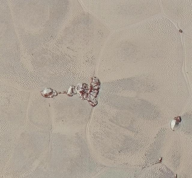
High-resolution images of Pluto taken by NASA's New Horizons spacecraft just before closest approach on July 14, 2015, are the sharpest images to date of Pluto's varied terrain-revealing details down to scales of 270 meters. In this 75-mile…

This image of Kerberos was created by combining four individual Long Range Reconnaissance Imager (LORRI) pictures taken on July 14, 2015, approximately seven hours before NASA's New Horizons' closest approach to Pluto, at a range of 245,600…

Global stereo mapping of Pluto surface is now possible, as images taken from multiple directions are downlinked from NASA New Horizons spacecraft. Stereo images will eventually provide an accurate topographic map of most of the hemisphere o…

In the early morning hours of July 8, 2015, mission scientists received this new view of Pluto -- the most detailed yet returned by the Long Range Reconnaissance Imager (LORRI) aboard New Horizons. The image was taken on July 7, when the NA…

A composite of enhanced color images of Pluto (lower right) and Charon (upper left), taken by NASA's New Horizons spacecraft as it passed through the Pluto system on July 14, 2015. This image highlights the striking differences between Plut…
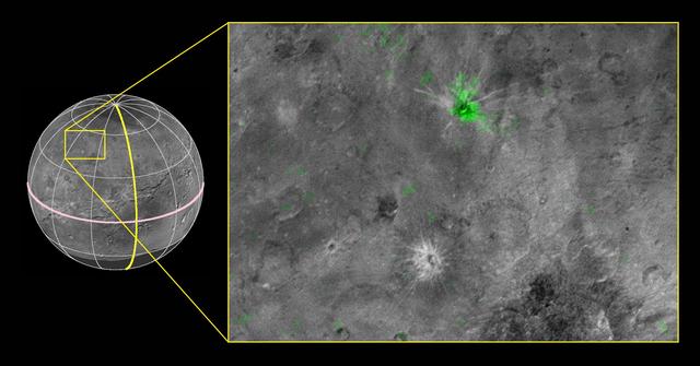
NASA's New Horizons scientists have discovered a striking contrast between one of the fresh craters on Pluto's largest moon Charon and a neighboring crater dotting the moon's Pluto-facing hemisphere. The crater, informally named Organa, cau…

High-resolution images of Charon were taken by the Long Range Reconnaissance Imager (LORRI) on NASA's New Horizons spacecraft, shortly before closest approach on July 14, 2015, and overlaid with enhanced color from the Ralph/Multispectral V…

These two images of Pluto and Charon were collected separately by NASA New Horizons during approach on July 13 and July 14, 2015. The relative reflectivity, size, separation, and orientations, and colors are approximated in this composite i…

Since its discovery in 2005, Pluto's moon Hydra has been known only as a fuzzy dot of uncertain shape, size, and reflectivity. Imaging obtained during NASA's New Horizons' historic transit of the Pluto-Charon system and transmitted to Earth…
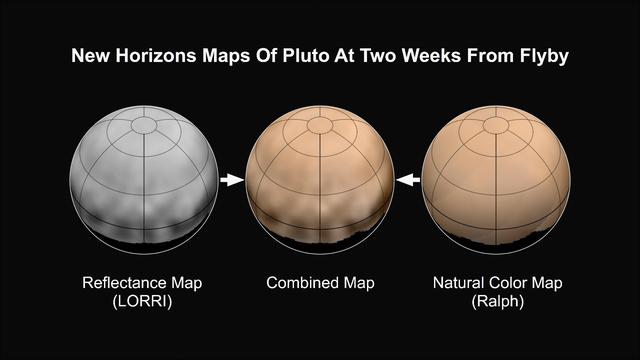
What color is Pluto? The answer, revealed in the first maps made from New Horizons data, turns out to be shades of reddish brown. The mission's first map of Pluto is in approximate true color -- that is, the color you would see if you were…
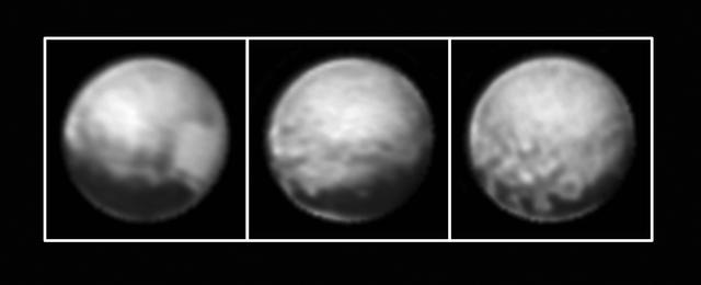
New Horizons' Long Range Reconnaissance Imager (LORRI) obtained these three images of Pluto between July 1-3 ,2015, as the spacecraft closed in on its July 14 encounter with the dwarf planet and its moons. The left image shows, on the right…

This image of Charon was taken by New Horizons' Long Range Reconnaissance Imager (LORRI) at 4:23 UT on July 9, 2015, from a range of 3.9 million miles (6.3 million kilometers). It reveals fascinating detail, never before seen, on the surfac…
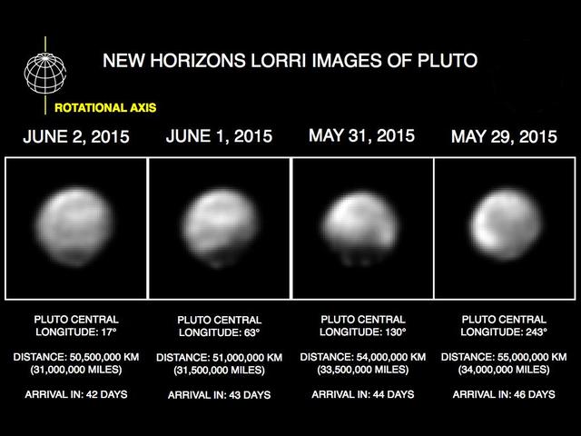
These images, taken by NASA's New Horizons' Long Range Reconnaissance Imager (LORRI), show four different "faces" of Pluto as it rotates about its axis with a period of 6.4 days. All the images have been rotated to align Pluto's rotational…
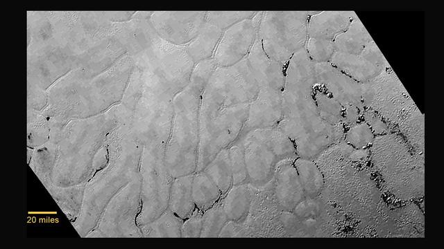
At center left of Pluto vast heart-shaped feature "Tombaugh Regio" -- lies a vast, craterless plain that appears to be no more than 100 million years old, and is possibly still being shaped by geologic processes as seen by NASA New Horizon…
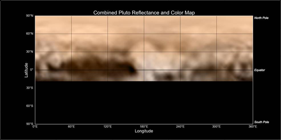
This map of Pluto, created from images taken from June 27-July 3, 2015, by the Long Range Reconnaissance Imager (LORRI) on New Horizons, was combined with lower-resolution color data from the spacecraft's Ralph instrument. The center of the…
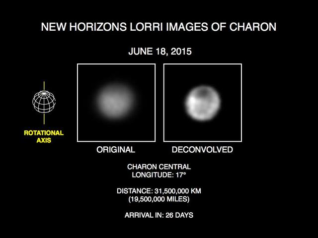
These recent images show the discovery of significant surface details on Pluto's largest moon, Charon. They were taken by the New Horizons Long Range Reconnaissance Imager (LORRI) on June 18, 2015. The image on the left is the original imag…
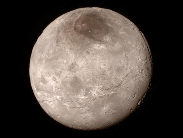
Remarkable new details of Pluto's largest moon Charon are revealed in this image from New Horizons' Long Range Reconnaissance Imager (LORRI), taken late on July 13, 2015 from a distance of 289,000 miles (466,000 kilometers). A swath of cli…
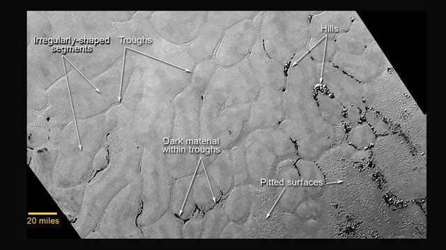
This annotated view of a portion of Pluto's Sputnik Planum (Sputnik Plain), named for Earth's first artificial satellite, shows an array of enigmatic features. The surface appears to be divided into irregularly shaped segments that are ring…
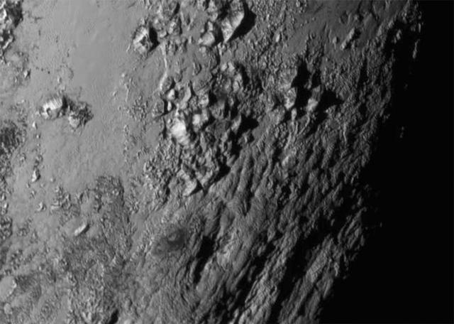
New close-up images of a region near Pluto's equator reveal a giant surprise: a range of youthful mountains rising as high as 11,000 feet (3,500 meters) above the surface of the icy body. The mountains likely formed no more than 100 millio…
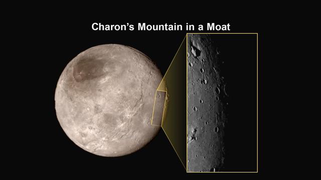
This image of an area on Pluto's largest moon Charon has a captivating feature -- a depression with a peak in the middle, shown here in the upper left corner of the inset. The image shows an area approximately 240 miles (390 kilometers) fro…

This illustration shows some of the final images used to determine that the coast is clear for New Horizons' flight through the Pluto system. These images show the difference between two sets of 48 combined 10-second exposures with New Hori…

The Ralph/LEISA infrared spectrometer on NASA's New Horizons spacecraft mapped compositions across Pluto's surface as it flew past the planet on July 14, 2015. On the left, a map of methane ice abundance shows striking regional differences,…
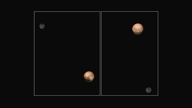
This pair of approximately true color images of Pluto and its big moon Charon, taken by NASA's New Horizons spacecraft, highlight the dramatically different appearance of different sides of the dwarf planet, and reveal never-before-seen det…

This color version of NASA's New Horizons Long Range Reconnaissance Imager (LORRI) picture of Pluto taken July 3, 2015, was created by adding color data from the Ralph instrument gathered earlier in the mission. The LORRI image was taken fr…

perspective view of Charon's informally named "Serenity Chasm" consists of topography generated from stereo reconstruction of images taken by New Horizons' Long Range Reconnaissance Imager (LORRI) and Multispectral Visible Imaging Camera (M…
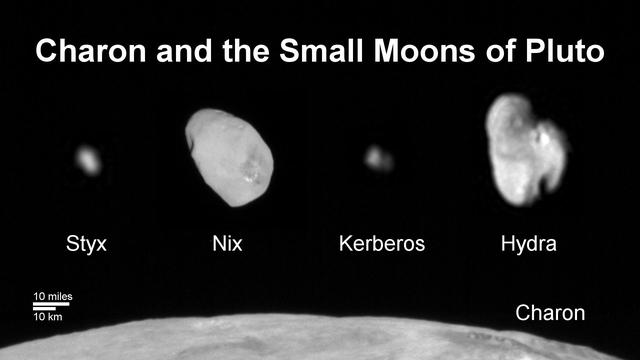
This composite image shows a sliver of Pluto large moon, Charon, and all four of Pluto small moons, as resolved by the Long Range Reconnaissance Imager (LORRI) on the New Horizons spacecraft. All the moons are displayed with a common intens…

Mosaic of high-resolution images of Pluto, transmitted by NASA's New Horizons spacecraft from Sept. 5 to 7, 2015. The image is dominated by the informally-named icy plain Sputnik Planum, the smooth, bright region across the center. This ima…
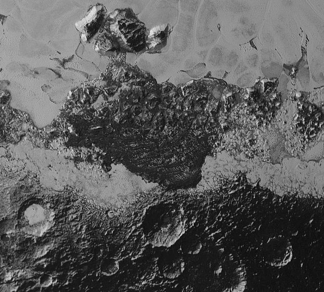
This 220-mile (350-kilometer) wide view of Pluto from NASA's New Horizons spacecraft illustrates the incredible diversity of surface reflectivities and geological landforms on the dwarf planet. The image includes dark, ancient heavily crate…
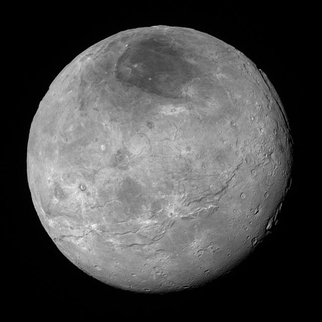
This image of Pluto's largest moon Charon, taken by NASA's New Horizons spacecraft 10 hours before its closest approach to Pluto on July 14, 2015 from a distance of 290,000 miles (470,000 kilometers), is a recently downlinked, much higher q…

This image of Pluto was taken by New Horizons' Long Range Reconnaissance Imager (LORRI) at 4:18 UT on July 9, 2015, from a range of 3.9 million miles (6.3 million kilometers). It reveals new details on the surface of Pluto, including comple…

This synthetic perspective view of Pluto, based on the latest high-resolution images to be downlinked from NASA's New Horizons spacecraft, shows what you would see if you were approximately 1,100 miles (1,800 kilometers) above Pluto's equat…

Images downloaded from NASA's New Horizons spacecraft (through Sept. 11, 2015) were stitched together and rendered on a sphere to make a flyover "movie." The animation, made with images from New Horizons' Long Range Reconnaissance Imager (L…
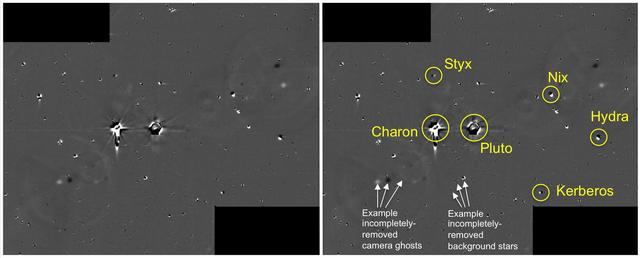
This illustration shows some of the final images used to determine that the coast was clear for New Horizons' flight through the Pluto system. These images show the difference between two sets of 48 combined 10-second exposures with the Lon…
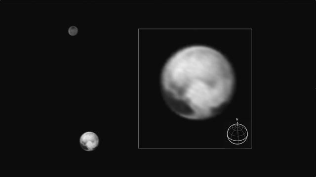
This image of Pluto and its big moon Charon was taken by NASA's New Horizons spacecraft at 04:15 (UTC) on July 1, 2015, and shows the clearest view yet of the sides of Pluto and Charon that will be studied in great detail during New Horizon…

Pluto nearly fills the frame in this image from the Long Range Reconnaissance Imager (LORRI) aboard New Horizons, taken on July 13, 2015, when the spacecraft was 476,000 miles (768,000 kilometers) from the surface. This is the last and most…

Mosaic of high-resolution images of Pluto, sent back from NASA's New Horizons spacecraft from Sept. 5 to 7, 2015. The image is dominated by the informally-named icy plain Sputnik Planum, the smooth, bright region across the center. This ima…

These circular maps shows the distribution of Pluto's dark and bright terrains as revealed by NASA's New Horizons mission prior to July 4, 2015. Each map is an azimuthal equidistant projection centered on the north pole, with latitude and l…
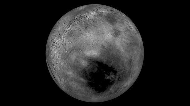
Images from NASA New Horizons spacecraft were used to create a flyover video (PIA19965) of Pluto largest moon, Charon. The flight starts with the informally named Mordor dark region near Charon north pole. In the video, the camera then move…
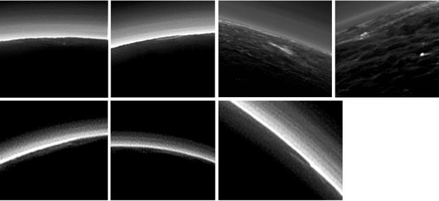
Pluto's present, hazy atmosphere is almost entirely free of clouds, though scientists from NASA's New Horizons mission have identified some cloud candidates after examining images taken by the New Horizons Long Range Reconnaissance Imager a…

What would it be like to actually land on Pluto? This image is one of more than 100 images taken by NASA's New Horizons spacecraft over six weeks of approach and close flyby in the summer of 2015. A video offers a trip down onto the surface…

This processed image is the highest-resolution color look yet at the haze layers in Pluto's atmosphere. Shown in approximate true color, the picture was constructed from a mosaic of four panchromatic images from the Long Range Reconnaissanc…
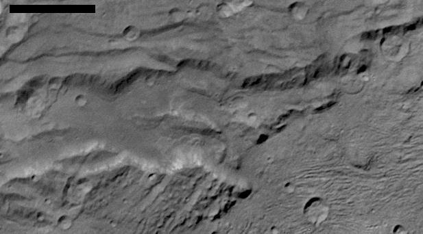
Scientists from NASA's New Horizons mission have spotted signs of long run-out landslides on Pluto's largest moon, Charon. This image of Charon's informally named "Serenity Chasma" was taken by New Horizons' Long Range Reconnaissance Imager…