SL3-28-009 (July-September 1973) --- A near vertical view of the Minneapolis-St. Paul, Minnesota area, as photographed from Earth orbit by one of the six lenses of the Itek-furnished S190-A Multispectral Photographic Facility Experiment in…
View of Minneapolis-St.Paul, Minnesota area
The Bight of Bangkok and the city of Bangkok, Thailand are visible in this west looking view. The city of Bangkok, with an estimated population in excess of 3.7 million people, can be seen in the lower right-hand corner of the view. The cit…
Infrared view of Bangkok, Thailand
SL3-27-224 (July-September 1973) --- A vertical view of the western portion of the Republic of Panama on the Isthmus of Panama as photographed from Earth orbit by one of the six lenses of the Itek-furnished S190-A Multispectral Photographic…
View of western portion of the Republic of Panama on Isthmus of Panama
SL3-33-167 (July-September 1973) --- A vertical view of the Argentina-Paraguay border area of South America as photographed from Earth orbit by one of the six lenses of the Itek-furnished S190-A Multispectral Photographic Facility Experimen…
View of Argentina-Paraguay border area of South America
SL3-87-299 (July-September 1973) --- A vertical view of southeastern New York State is seen in this Skylab 3 Earth Resources Experiments Package S190-B (five-inch Earth terrain camera) infrared photograph taken from the Skylab space station…
View of southeastern New York State
SL3-88-004 (July-September 1973) --- A vertical view of the Salinas River Valley area south of Monterey Bay, California area is seen in this Skylab 3 Earth Resources Experiments Package S190-B (five-inch Earth terrain camera) photograph tak…
View of the Salinas River Valley area south of Monterey Bay, California
SL4-92-300 (February 1974) --- A near vertical view of the Mobile Bay, Alabama area is seen in this Skylab 4 Earth Resources Experiments Package S190-B (five-inch earth terrain camera) photograph taken from the Skylab space station in Earth…
Mobile Bay, Alabama area seen in Skylab 4 Earth Resources Experiment Package
SL2-03-118 (June 1973) --- An infrared photograph of the San Francisco Bay, California area, taken from the Skylab 1/2 space station in Earth orbit. THE PICTURE SHOULD BE HELD WITH THE CLOUDS AND PACIFIC OCEAN ON THE LEFT. This photograph w…
San Francisco and Bay Area, CA, USA
SL2-03-126 (June 1973) --- A color infrared photograph of the Los Angeles County and Kern County area, taken from the Skylab space station in Earth orbit during its first manned Skylab mission. The Mojave Desert occupies the northeast one-f…
Mojave Desert, California
SL3-45-020 (July-September 1973) --- A vertical view of the Virginia-Tennessee-Kentucky border area as photographed from Earth orbit by one of the six lenses of the Itek-furnished S190-A Multispectral Photographic Facility Experiment aboard…
View of Virginia, Tennessee, Kentucky border area
STS039-89-053 (28 April-6 May 1991) --- A 70mm, infrared frame of the city of San Francisco, taken on a clear day. The gray areas represent urban regions, and the red areas are vegetated.  Within the city of San Francisco, parks like Golden…
San Francisco and Bay Area, CA, USA
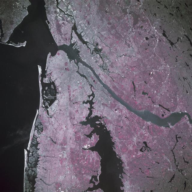
STS039-88-054 (28 April-6 May 1991) --- The dense urban development of the New York City metropolitan area in downstate New York, Long Island and New Jersey shows up as gray and white on this color Infrared photograph. The scene was taken o…
New York City, Hudson River, NY, USA
SL3-87-355 (July-September 1973) --- A vertical view of the eastern coast of Sicily area is seen in this Skylab 3 Earth Resources Experiments Package S190-B (five-inch earth terrain camera) infrared photograph taken from the Skylab space st…
View of eastern coast of Sicily area
This color infrared view of Houston (29.5N, 95.0W) was taken with a dual camera mount. Compare this scene with STS048-78-034 for an analysis of the unique properties of each film type. Comparative tests such as this aids in determining the…
Color Infrared view of Houston, TX, USA
SL2-03-192 (22 June 1973) --- Lake Mead, Nevada, (36.0N, 114.5E) where the water from the Colorado River empties after it's 273 mile journey through the Grand Canyon of Arizona is the subject of this photo. Other features of interest are Ho…
Lake Mead, NV
SL2-03-200 (22 June 1973) --- The city of Phoenix, AZ (33.5N, 112.0W) can be seen in good detail in this color infrared scene. Situated among truck crop agriculture fields, the color infrared photo depicts the vegetated fields as shades of…
Phoenix, AZ, USA
SL4-93-167 (February 1974) --- A vertical view of the Kennedy Space Center and the Florida Atlantic coast area is seen in this Skylab 4 Earth Resources Experiments Package S190-B (five-inch earth terrain camera) infrared photography taken f…
Kennedy Space Center and the Florida Atlantic coast area
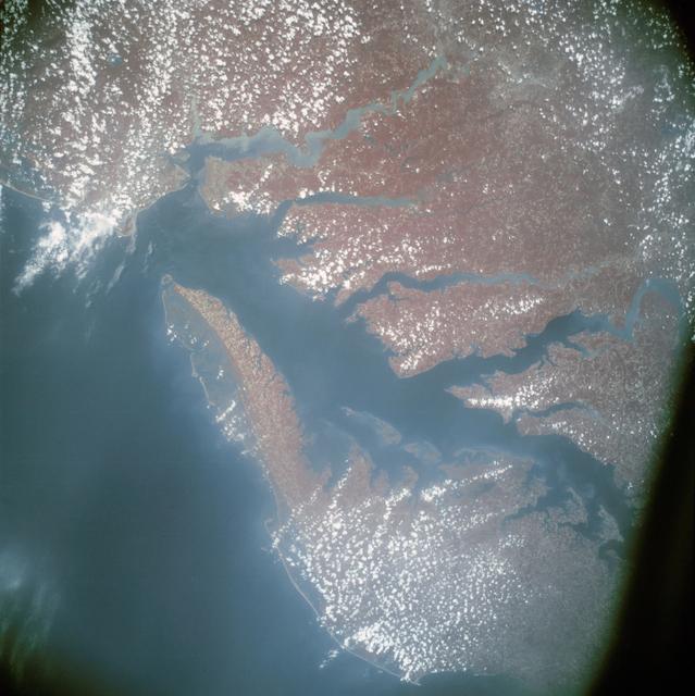
AST-13-797 (24 July 1975) --- An infrared, near vertical view of the Chesapeake Bay area showing portions of Virginia, Maryland and Delaware, as photographed from the Apollo spacecraft in Earth orbit during the joint U.S.-USSR Apollo-Soyuz…
Infrared view of Chesapeake Bay showing Virginia, Maryland and Delaware
STS039-87-012 (28 April-6 May 1991) --- A handheld 70mm camera onboard the Space Shuttle Discovery exposed this infrared frame showing oil fires near the Kuwait coast as well as south-bound oil slicks in the Gulf. Pools of oil on the land a…
Oil Fires and Oil Slick, Kuwait
SL4-93-153 (February 1974) --- A vertical view of the Birmingham and central Alabama area is seen in this Skylab 4 Earth Resources Experiments Package S190-B (five-inch earth terrain camera) infrared photographed taken from the Skylab space…
Birmingham and central Alabama area seen in Earth Resources Exp. Package
No more images