
On Sept. 7, the Multi-angle Imaging SpectroRadiometer (MISR) instrument on NASA's Terra satellite passed over Hurricane Irma at approximately 11:20 am local time. The MISR instrument comprises nine cameras that view the Earth at different a…

The Central Campus construction site is seen during an aerial survey of NASA's Kennedy Space Center in Florida on September 12, 2017. The survey was performed to identify structures and facilities that may have sustained damage from Hurrica…

The Central Campus construction site is seen during an aerial survey of NASA's Kennedy Space Center in Florida on September 12, 2017. The survey was performed to identify structures and facilities that may have sustained damage from Hurrica…

Kars Park I is seen during an aerial survey of NASA's Kennedy Space Center in Florida on September 12, 2017. The survey was performed to identify structures and facilities that may have sustained damage from Hurricane Irma as the storm pass…

Kars Park I is seen during an aerial survey of NASA's Kennedy Space Center in Florida on September 12, 2017. The survey was performed to identify structures and facilities that may have sustained damage from Hurricane Irma as the storm pass…

The Mobile Launcher (ML), Launch Control Center (LCC), Vehicle Assembly Building (VAB), and Launch Complex 39 surrounding areas are seen during an aerial survey of NASA's Kennedy Space Center in Florida on September 12, 2017. The survey was…

The Vehicle Assembly Building (VAB), Launch Control Center (LCC), and Launch Complex 39 surrounding areas are seen during an aerial survey of NASA's Kennedy Space Center in Florida on September 12, 2017. The survey was performed to identify…

An industrial building behind the Space Station Processing Facility (SSPF) is seen during an aerial survey of NASA's Kennedy Space Center in Florida on September 12, 2017. The survey was performed to identify structures and facilities that…

The Kennedy Space Center Visitor Complex is seen during an aerial survey of NASA's Kennedy Space Center in Florida on September 12, 2017. The survey was performed to identify structures and facilities that may have sustained damage from Hur…

The Mobile Launcher (ML), Vehicle Assembly Building (VAB), Launch Control Center (LCC), and Launch Complex 39 surrounding areas are seen during an aerial survey of NASA's Kennedy Space Center in Florida on September 12, 2017. The survey was…

A guard shack at the Shuttle Landing Facility, operated by Space Florida, is seen during a survey of NASA's Kennedy Space Center in Florida on September 12, 2017. The survey was performed to identify structures and facilities that may have…

The Blue Origin construction site at Exploration Park is seen during an aerial survey of NASA's Kennedy Space Center in Florida on September 12, 2017. The survey was performed to identify structures and facilities that may have sustained da…

A boat dock torn apart is seen during a survey of NASA's Kennedy Space Center in Florida on September 12, 2017. The survey was performed to identify structures and facilities that may have sustained damage from Hurricane Irma as the storm p…
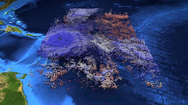
The large-scale structure of clouds in and around Hurricane Irma is seen in this animation and still image created with data from the Atmospheric Infrared Sounder (AIRS) instrument on NASA's Aqua satellite. The clouds are typical of tropica…
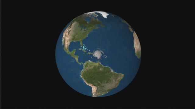
NASA's CloudSat satellite flew over Hurricane Irma on Sept. 6, 2017 at 1:45 p.m. EDT (17:45 UTC) as the storm was approaching Puerto Rico in the Atlantic Ocean. Hurricane Irma contained estimated maximum sustained winds of 185 miles per hou…

Launch Complex 39 surrounding areas are seen during an aerial survey of NASA's Kennedy Space Center in Florida on September 12, 2017. The survey was performed to identify structures and facilities that may have sustained damage from Hurrica…

A tank stroage unit near Launch Complex 39 is seen during an aerial survey of NASA's Kennedy Space Center in Florida on September 12, 2017. The survey was performed to identify structures and facilities that may have sustained damage from H…

The Central Campus construction site and Headquarters building are seen during an aerial survey of NASA's Kennedy Space Center in Florida on September 12, 2017. The survey was performed to identify structures and facilities that may have su…

Launch Complex 39B is seen during an aerial survey of NASA's Kennedy Space Center in Florida on September 12, 2017. The survey was performed to identify structures and facilities that may have sustained damage from Hurricane Irma as the sto…

The shoreline is seen during an aerial survey of NASA's Kennedy Space Center in Florida on September 12, 2017. The survey was performed to identify structures and facilities that may have sustained damage from Hurricane Irma as the storm pa…

The Mobile Launcher (ML), Vehicle Assembly Building (VAB), Launch Control Center (LCC), and Launch Complex 39 surrounding areas are seen during an aerial survey of NASA's Kennedy Space Center in Florida on September 12, 2017. The survey was…

The Kennedy Space Center Visitor Complex is seen during an aerial survey of NASA's Kennedy Space Center in Florida on September 12, 2017. The survey was performed to identify structures and facilities that may have sustained damage from Hur…

The Launch Control Center (LCC) is seen during an aerial survey of NASA's Kennedy Space Center in Florida on September 12, 2017. The survey was performed to identify structures and facilities that may have sustained damage from Hurricane Ir…

The Multi-Payload Processing Facility (MPPF) is seen during an aerial survey of NASA's Kennedy Space Center in Florida on September 12, 2017. The survey was performed to identify structures and facilities that may have sustained damage from…

A trailer flipped on it's side at the Turn Basin is seen during a survey of NASA's Kennedy Space Center in Florida on September 12, 2017. The survey was performed to identify structures and facilities that may have sustained damage from Hur…

The Multi-Payload Processing Facility (MPPF) is seen during an aerial survey of NASA's Kennedy Space Center in Florida on September 12, 2017. The survey was performed to identify structures and facilities that may have sustained damage from…

On Sept. 7, the Multi-angle Imaging SpectroRadiometer (MISR) instrument on NASA's Terra satellite passed over Hurricane Irma at approximately 11:20 a.m. local time. The MISR instrument comprises nine cameras that view the Earth at different…
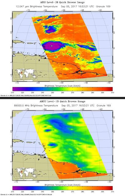
Hurricane Irma is the strongest hurricane ever recorded outside the Caribbean Sea and Gulf of Mexico. These two images from the Atmospheric Infrared Sounder (AIRS) instrument aboard NASA's Aqua satellite show what Hurricane Irma looked like…

Launch Complex 39B is seen during an aerial survey of NASA's Kennedy Space Center in Florida on September 12, 2017. The survey was performed to identify structures and facilities that may have sustained damage from Hurricane Irma as the sto…

The Beach House is seen during an aerial survey of NASA's Kennedy Space Center in Florida on September 12, 2017. The survey was performed to identify structures and facilities that may have sustained damage from Hurricane Irma as the storm…

The Launch Complex 39 Press Site is seen during an aerial survey of NASA's Kennedy Space Center in Florida on September 12, 2017. The survey was performed to identify structures and facilities that may have sustained damage from Hurricane I…

The Blue Origin construction site at Exploration Park is seen during an aerial survey of NASA's Kennedy Space Center in Florida on September 12, 2017. The survey was performed to identify structures and facilities that may have sustained da…

Center Director, Robert Cabana, conducts an aerial survey of NASA's Kennedy Space Center in Florida on September 12, 2017. The survey was performed to identify structures and facilities that may have sustained damage from Hurricane Irma as…

Kars Park I is seen during an aerial survey of NASA's Kennedy Space Center in Florida on September 12, 2017. The survey was performed to identify structures and facilities that may have sustained damage from Hurricane Irma as the storm pass…

The Operations Support Building I (OSB I) is seen during an aerial survey of NASA's Kennedy Space Center in Florida on September 12, 2017. The roof of the building is currently undergoing repair from Hurricane Matthew. The survey was perfor…

Launch Complex 39 surrounding areas are seen during an aerial survey of NASA's Kennedy Space Center in Florida on September 12, 2017. The survey was performed to identify structures and facilities that may have sustained damage from Hurrica…

This pair of images shows ocean surface wind speeds for Hurricane Irma as observed at 5:26 a.m. EDT on Sept. 4, 2017 (top) and 24.5 hours later at 6:02 a.m. EDT on September 5th (bottom) by the radiometer instrument on NASA's Soil Moisture…