
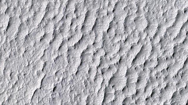
This image from NASA's Mars Reconnaissance Orbiter shows small ripples, about 10 meters apart, located in Her Desher Vallis. Her Desher is a small channel that shows evidence of phyllosilicates -- silicates with a sheet-like structure, such…

The goal of this observation from NASA' Mars Reconnaissance Orbiter (MRO) is to determine the source of the ridge within a possible moraine that is also present in another HiRISE image. A moraine is a mass of rocks and sediment carried down…

This image from NASA's Mars Reconnaissance Orbiter (MRO) shows two small impact craters located in Meridiani Planum. This is an example of the geologic principle of superposition: figuring out what happened first by looking at how features…

This image from NASA's Mars Reconnaissance Orbiter (MRO) captures details of an approximately 1-kilometer inverted crater west of Mawrth Vallis. A Context Camera image provides context for the erosional features observed at this site. The l…

The material on the floor of this crater appears to have flowed like ice, and contains pits that might result from sublimation of subsurface ice. The surface is entirely dust-covered today. There probably was ice here sometime in the past,…

The layered sedimentary deposits inside the giant canyons of Mars have puzzled scientists for decades. These light toned deposits have fine, horizontal laminations that are unlike the rugged rim rock of the Valles Marineris as seen by NASA'…

The extended-mission status of the Mars Reconnaissance Orbiter and the HiRISE camera has greatly increased our understanding of numerous active processes occurring on Mars. By taking carefully planned repeat images of surface, we now have a…

There is a circular feature in this observation from NASA Mars Reconnaissance Orbiter spacecraft that appears to stand above the surrounding terrain. This feature is probably an inverted crater that was filled in with sediment. The fill bec…

This image, acquired by NASA's Mars Reconnaissance Orbiter on Sept. 16, 2013, shows Roddy Crater on Mars, home to several large alluvial fans, which formed as water moved sediment from the mountainous crater rim and deposited it onto the fl…

Ground cemented by ice cover the high latitudes of Mars, much as they do on Earth's cold climates. A common landform that occurs in icy terrain are polygons as shown in this image from NASA's Mars Reconnaissance Orbiter (MRO). Polygonal pa…

Intricate gullies have formed on the northern wall of this impact crater located in the Terra Cimmeria region in this image from NASA's Mars Reconnaissance Orbiter (MRO). This crater may have formed in a region rich in ground water. This g…

Various researchers are often pre-occupied with the quest for flowing water on Mars. However, this image from NASA's Mars Reconnaissance Orbiter (MRO), shows one of the many examples from Mars where lava (when it was molten) behaved in a si…

The rotational axis of Mars is currently tilted by about 25 degrees, very similar to that of the Earth (at 23.4 degrees). However, while Earth's axial tilt (also known as "obliquity") tends to change very slightly over time (almost 3 degree…

This image from NASA's Mars Reconnaissance Orbiter (MRO) shows the eastern rim of a small 3.5-kilometer crater which appears to have collapsed into a much larger crater (about 14-kilometers wide). The larger crater has a large ice flow arou…

This image from NASA's Mars Reconnaisance Orbiter (MRO) shows a dune field in Chasma Boreale, which is a large trough that cuts into the North Polar ice cap. Some of the dunes in this image are quite long and sinuous with a slight bulge at…

This image is an oblique view from NASA's Mars Reconnaissance Orbiter of the sloping edge of the stack of icy layers over the South Pole has some interesting morphologies. The slope appears to be eroding from a combination of landslides, b…

The North Polar layered deposits are a 3-kilometer thick stack of dusty water ice layers that are about 1000 kilometers across. The layers record information about climate stretching back a few million years into Martian history. In many l…

This hill in the South Polar layered deposits has influenced the erosion of the icy layers as seen by by NASA Mars Reconnaissance Orbiter. The hill protects the layers from erosion, so the pattern of erosion to the sides of the hill forms a…

This image from NASA Mars Reconnaissance Orbiter shows two small craters called tangential craters, just touching on their rims, in the much larger Ptolmaeus Crater, which is located in the Martian Southern hemisphere. These craters are cal…

Gullies are commonly found in the southern mid-latitudes of Mars. In this image from NASA Mars Reconnaissance Orbiter they start near top of a long ridge, and descend into an impact crater that lies at the bottom of the ridge, moving throu…
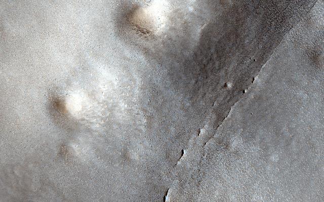
This image shows many small craters over a larger degraded one in the northern lowlands. These small craters are smoother and shallower than their counterparts closer to the equator. Scientists believe this difference is a result of impact…

The dark dunes in the western Medusae Fossae formation provide some evidence of having a local origin. This image shows no large dunes, but many of the dark sand patches cover slopes up to discrete layers. It is possible that the sand is e…
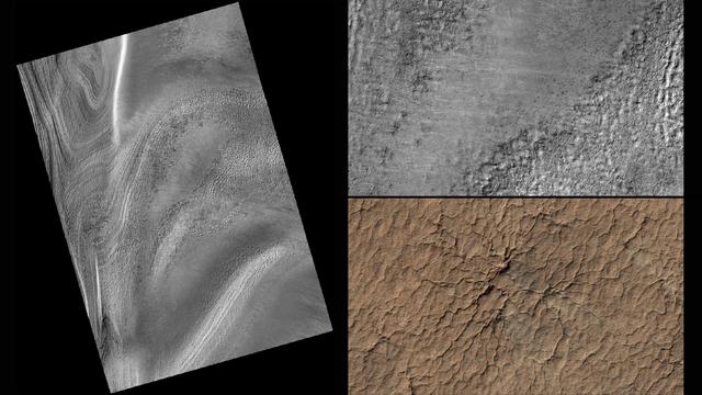
This series of images from NASA's Mars Reconnaissance Orbiter successively zooms into "spider" features -- or channels carved in the surface in radial patterns -- in the south polar region of Mars. In a new citizen-science project, voluntee…

The terrain in this observation from NASA Mars Reconnaissance Orbiter looks like an ancient uplifted crustal block. The area is riddled with faults big cracks that allow rocks to slide and ridges that look like uncovered magma dikes. A Mar…

This color image from NASA's Mars Reconnaissance Orbiter (MRO) shows bedrock layers of diverse colors and composition. For more information see https://photojournal.jpl.nasa.gov/catalog/PIA22437

This enhanced-color sample reveals the incredible diversity of landforms on some Martian plains that appear bland and uniform at larger scales. Here we see layers, small channels suggesting water flow, craters, and indurated sand dunes. T…

This image from NASA's Mars Reconnaissance Orbiter (MRO) was originally meant to track the movement of sand dunes near the North Pole of Mars, but what's on the ground in between the dunes is just as interesting! The ground has parallel da…

A delta is a pile of sediment dumped by a river where it enters a standing body of water. Evidence for deltas that formed billions of years ago on Mars has been mounting in recent years. One line of evidence not yet investigated is to sea…

This 2008 image shows a portion of the North Polar layered deposits with lines of very small pits, only about 1 meter in diameter. Such small pits should be quickly filled in by seasonal ice and dust, so their existence suggests active pro…

This image from NASA Mars Reconnaissance Orbiter shows a portion of a long valley system in northern Arabia Terra. The valley must be relatively young because it cuts through the ejecta of an impact crater that still retains it entire eject…

Ground that has a lot of water ice mixed with dirt tends to crack in polygonal patterns bounded by short straight channels. In the South Polar region of Mars this type of terrain may be covered by a seasonal polar cap composed of dry ice.…

Gullies are often found on steep slopes. In the winter, this area is covered with a layer of carbon dioxide ice (dry ice). In the spring, when the ice warms up and transitions to gas, it dislodges material on the slope, forming a gully. In…
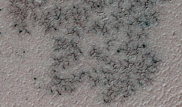
This image shows spidery channels eroded into Martian ground. It is an example from high-resolution observation of more than 20 places that were chosen in 2016 on the basis of about 10,000 volunteers' examination of lower-resolution images…

This image captured by NASA Mars Reconnaissance Orbiter spacecraft targets a 3-kilometer diameter crater that occurs within the ejecta blanket of the much older Bakhuysen Crater, a 150-kilometer diameter impact crater in Noachis Terra. Imp…

This image from NASA Mars Reconnaissance Orbiter spacecraft shows the nature of the terrain at the rim of Marth Crater. In the book "The Martian" by Andy Weir, stranded astronaut Mark Watney is headed for the Ares 4 landing site but encoun…

One small section of this image shows boulders that have rolled down the slope of a crater wall. The boulders vary in size, with the largest one approximately 6 meters across. Unlike the boulder in a previous image, this one is not standing…
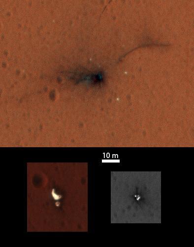
On Nov. 1, 2016, the High Resolution Imaging Science Experiment (HiRISE) camera on NASA's Mars Reconnaissance Orbiter observed the impact site of Europe's Schiaparelli test lander, gaining the first color view of the site since the lander's…

This enhanced-color image from NASA Mars Reconnaissance Orbiter shows gullies in the northern wall of an unnamed crater in Utopia Planitia. The banked, sinuous shape of the gully channels suggest that water was involved in their formation.…

This image shows the edge of the Martian South Polar layered deposit. The stack of fine layering is highlighted by the rays of the polar sun. These layers show the pervasive red coloring of Mars which have built up over the ages. While thi…

This image was acquired on May 30, 2018 by NASA's Mars Reconnaissance Orbiter. This image shows inverted channels within a fan whose origin could be either fluvial (produced by the action of a stream) or alluvial (created by sedimentary dep…

One of the most actively changing areas on Mars are the steep edges of the North Polar layered deposits. This image from NASA's Mars Reconnaissance Orbiter (MRO) shows many new ice blocks compared to an earlier image in December 2006. An an…

This image from NASA's Mars Reconnaissance Orbiter (MRO) shows bedrock units with diverse colors indicating different mineral concentrations. More information is available at https://photojournal.jpl.nasa.gov/catalog/PIA22434
This image from the High Resolution Imaging Science Experiment (HiRISE) camera on NASA's Mars Reconnaissance Orbiter shows a location on Mars associated with the best-selling novel and Hollywood movie, "The Martian." It is the science-ficti…

Subtle variations in color look like brush strokes as the lightly frosted terrain reflects light. These variations provide a backdrop to some exotic features referred to colloquially as "spiders." The radial channels branching out from a c…

Gullies on Martian sand dunes, like these in Matara Crater, have been very active, with many flows in the last ten years. The flows typically occur when seasonal frost is present. In this image from NASA's Mars Reconnaissance Orbiter we se…

The objective of this observation from NASA Mars Reconnaissance Orbiter is to examine a light-toned deposit in a region of what is called "chaotic terrain." There are indications of layers in the image. Some shapes suggest erosion by a fl…

Roadside bedrock outcrops are all too familiar for many who have taken a long road trip through mountainous areas on Earth. Martian craters provide what tectonic mountain building and man's TNT cannot: crater-exposed bedrock outcrops. Alth…

This image from NASA's Mars Reconnaissance Orbiter (MRO) targets a portion of a group of honeycomb-textured landforms in northwestern Hellas Planitia, which is part of one of the largest and most ancient impact basins on Mars. In a larger…