ZERO GRAVITY AIRCRAFT KC135 FLIGHTS AT LEWIS RESEARCH CENTER (Glenn Research Center)
GRC-1994-C-00846
Group photo representating past and present Multi-Media Services (MMS) photographer and videographers that have supported Zero-G Reduced Gravity Office operations throughout the year prior to the programs final flight on August 29, 2014.  P…
jsc2014e078835_alt
An experiment vehicle plunges into the deceleration pit at the end of a 5.18-second drop in the Zero-Gravity Research Facility at NASA's Glenn Research Center. The Zero-Gravity Research Facility was developed to support microgravity researc…
Microgravity
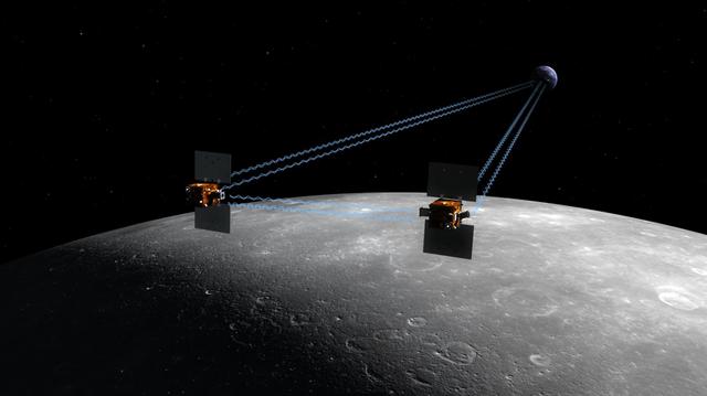
An artist depiction of the twin spacecraft Ebb and Flow that comprise NASA GRAIL mission. As Ebb and Flow fly over areas of greater and lesser gravity surface features can influence the distance between the two spacecraft.
GRAIL Spacecraft Over the Moon Artist Concept
Spacecraft technicians monitor the movement of a section of the clamshell-shaped Delta payload fairing as it encloses NASA twin Gravity Recovery and Interior Laboratory spacecraft at Cape Canaveral Air Force Station in Florida on Aug. 23, 2…
GRAIL Twins are Covered
Larry DeLucas with the (LBNP) Lower Body Negative Pressure Experiment onboard STS-50.
Microgravity
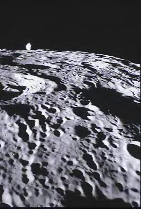
This image of the far side of the lunar surface, with Earth in the background, is of crater De Forest and was taken by NASA MoonKAM system onboard the Ebb spacecraft.
MoonKAM Looks Homeward
The Gravity Recovery and Interior Laboratory, or GRAIL, mission will fly twin spacecraft in tandem orbits around the moon to measure its gravity field in unprecedented detail. GRAIL is a part of NASA Discovery Program.
New NASA Mission to Reveal Moon Internal Structure and Evolution Artist Concept
This  still image features a free-air gravity map of the Moon's southern latitudes developed by S. Goossens et al. from data returned by the Gravity Recovery and Interior Laboratory (GRAIL) mission.  If the Moon were a perfectly smooth sphe…
Free-Air Gravity Map of the Moon
This is a polar stereographic map of gravity of the north polar region of the moon from the Gravity Recovery and Interior Laboratory GRAIL mission. The map displays the region from latitude 60 north to the pole.
Gravity at the Moon North Pole
Cumulative total freshwater losses in the United States from 2002 to 2015 (in inches) observed by NASA's Gravity Recovery and Climate Experiment (GRACE) mission. Total water refers to all of the snow, surface water, soil water and groundwat…
Cumulative Total U.S. Freshwater Losses as Seen by NASA GRACE, 2002-15
Cumulative total freshwater losses in South America from 2002 to 2015 (in inches) observed by NASA's Gravity Recovery and Climate Experiment (GRACE) mission. Total water refers to all of the snow, surface water, soil water and groundwater c…
Cumulative Total South America Freshwater Losses as Seen by NASA GRACE, 2002-15
Cumulative total freshwater losses in North Africa and the Middle East from 2002 to 2015 (in inches) observed by NASA's Gravity Recovery and Climate Experiment (GRACE) mission. Total water refers to all of the snow, surface water, soil wate…
Cumulative Total Middle East/North Africa Freshwater Losses as Seen by NASA GRACE, 2002-15
Cumulative total freshwater losses in South Asia from 2002 to 2015 (in inches) observed by NASA's Gravity Recovery and Climate Experiment (GRACE) mission. Total water refers to all of the snow, surface water, soil water and groundwater comb…
Cumulative Total India Freshwater Losses as Seen by NASA GRACE, 2002-15
The Gravity Recovery and Interior Laboratory GRAIL mission utilizes the technique of twin spacecraft flying in formation with a known altitude above the lunar surface and known separation distance to investigate the gravity field of the moo…
GRAIL Twin Spacecraft fly in Tandem Around the Moon Artist Concept
This frame from an animation based on data from NASA Grace satellite shows dramatic changes in Greenland ice mass from 2003 through 2011 revealing how much ice has been lost and gained each year.
Ice Mass Loss on Greenland, 2003-2011
NASA's GRACE mission produced maps of anomalies in Earth's gravity field almost every month from April 2002 to June 2017.  https://photojournal.jpl.nasa.gov/catalog/PIA22448
Monthly GRACE Gravity Anomaly Maps
An experiment vehicle plunges into the deceleration at the end of a 5.18-second drop in the Zero-Gravity Research Facility at NASA's Glenn Research Center. The Zero-Gravity Research Facility was developed to support microgravity research an…
Microgravity
An experiment vehicle plunges into the deceleration pit at the end of a 5.18-second drop in the Zero-Gravity Research Facility at NASA's Glenn Research Center. The Zero-Gravity Research Facility was developed to support microgravity researc…
Microgravity
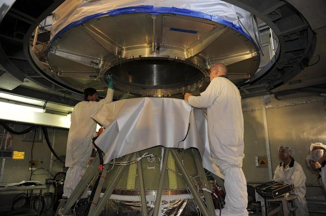
NASA twin Gravity Recovery and Interior Laboratory GRAIL spacecraft are lowered onto the second stage of their Delta II launch vehicle. At top is the spacecraft adapter ring which holds the two lunar probes in their side-by-side launch conf…
GRAIL Mission Comes Together
Using a precision formation-flying technique, the twin GRAIL spacecraft maps the moon gravity field, as depicted in this artist rendering.
GRAIL Artist Rendition
If the Moon were a perfectly smooth sphere of uniform density, the gravity map would be a single, featureless color, indicating that the force of gravity at a given elevation was the same everywhere. But like other rocky bodies in the solar…
Free-Air Gravity Map of the Moon
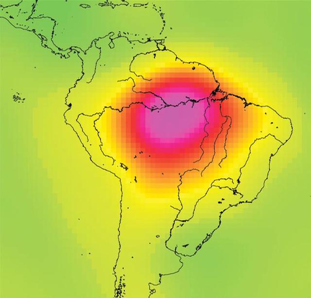
This image is from data taken by NASA Gravity Recovery and Climate Experiment showing the Amazon basin in South America. The amount of water stored in the Amazon basin varies from month to month. Animations are available at the Photojournal…
Measuring Water Storage in the Amazon
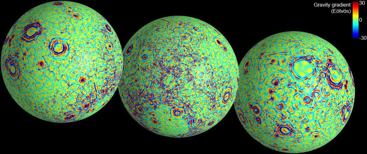
These maps of the near and far side of the moon show gravity gradients as measured by NASA GRAIL mission. Red and blue areas indicate stronger gradients due to underlying mass anomalies.
GRAIL Gravity Gradients
This figure shows the effect of the December 2004 great Sumatra earthquake on the Earth’s gravity field as observed by NASA GRACE.
Earthquake Signal Visible in GRACE Data
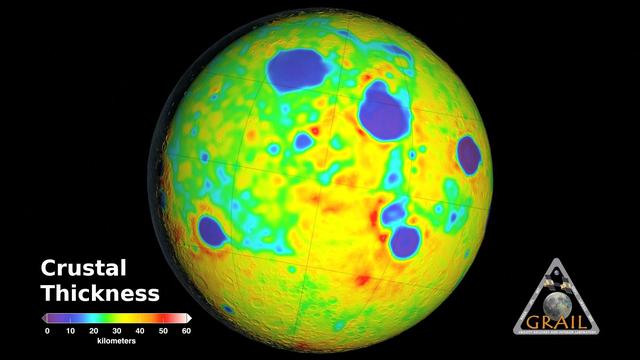
Map of Moon Crust
Map of Moon Crust
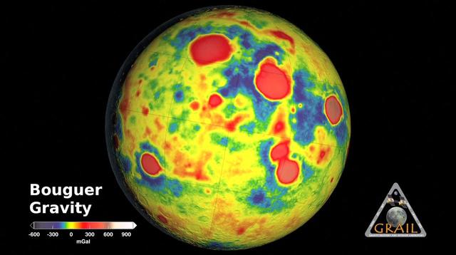
GRAIL Bouguer Gravity Moon Map
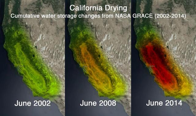
This trio of images depicts satellite observations of declining water storage in California as seen by NASA Gravity Recovery and Climate Experiment satellites in June 2002 left, June 2008 center and June 2014 right.
NASA GRACE Sees a Drying California
A profile across one of the linear gravity anomalies found by NASA GRAIL mission shows that it has higher gravity than the surroundings.
GRAIL Identifies Moon Dikes
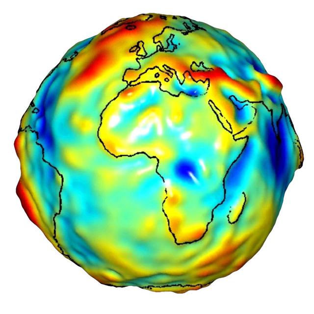
This visualization of a gravity model was created with data from NASA’s Gravity Recovery and Climate Experiment and shows variations in the gravity field across Africa and Europe.
Global Gravity: Africa and Europe
Gravity is the force that is responsible for the weight of an object and is determined by how the material that makes up the Earth is distributed throughout the Earth.
New Views of Earth Gravity Field from GRACE
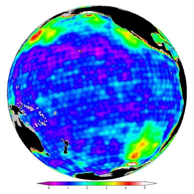
This map shows changes in ocean bottom pressure measured by NASA Gravity Recovery and Climate Experiment.
New Look at Gravity Data Sheds Light on Ocean and Climate
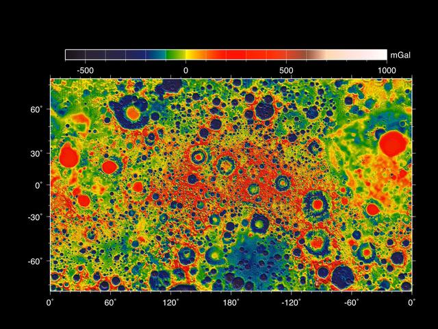
This map shows the gravity field of the moon as measured by NASA GRAIL mission. The viewing perspective, known as a Mercator projection, shows the far side of the moon in the center and the nearside as viewed from Earth at either side.
GRAIL Gravity Field of the Moon
ZERO GRAVITY AIRCRAFT KC135 FLIGHTS AT LEWIS RESEARCH CENTER
GRC-1994-C-00849
An experiment vehicle plunges into the deceleration pit at the end of a 5.18-second drop in the Zero-Gravity Research Facility at NASA's Glenn Research Center. The Zero-Gravity Research Facility was developed to support microgravity researc…
Microgravity
An artist depiction of the twin spacecraft that comprise NASA GRAIL mission. During the GRAIL mission science phase, spacecraft Ebb and Flow transmit radio signals precisely defining the distance between them as they orbit the moon in forma…
NASA GRAIL Spacecraft in Science Collection Phase Artist Concept
The Reduced-Gravity Program provides the unique weightless or zero-g environment of space flight for testing and training of human and hardware reactions. The reduced-gravity environment is obtained with a specially modified KC-135A turboje…
Microgravity
Using a precision formation-flying technique, NASA twin GRAIL spacecraft will map the moon gravity field. This is an artist concept.
GRAIL Flying in Formation Artist Concept
In this photo, taken April 29, 2011, technicians install lifting brackets prior to hoisting the 200-kilogram 440-pound GRAIL-A spacecraft out of vacuum chamber after testing.
Testing the GRAIL Twins
Gravity Probe B (GP-B) is the relativity experiment developed at Stanford University to test two extraordinary predictions of Albert Einstein’s general theory of relativity. This photograph is of the Gravity Probe B flight dewar, a metal co…
Space Science
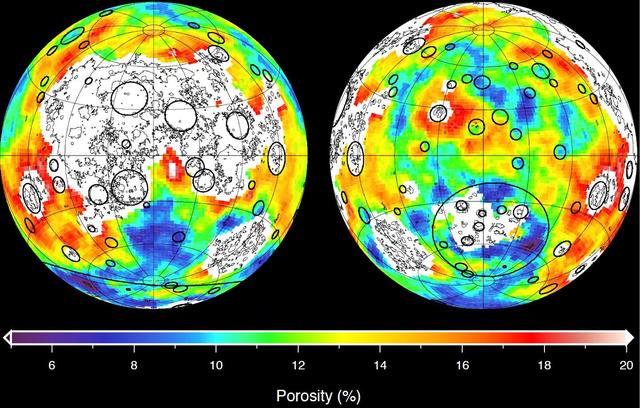
This image depicting the porosity of the lunar highland crust was derived using bulk density data from NASA GRAIL mission and independent grain density measurements from NASA Apollo moon mission samples as well as orbital remote-sensing dat…
Closer Look at Lunar Highland Crust
The Gravity Recovery and Interior Laboratory GRAIL mission utilizes the technique of twin spacecraft flying in formation with a known altitude above the lunar surface and known separation distance to investigate the gravity field of the moo…
GRAIL Twin Spacecraft -- Crust to Core Artist Concept
This visualization of a gravity model was created with data from NASA Gravity Recovery and Climate Experiment GRACE and shows variations in Earth’s gravity field.
GRACE Global Gravity Animation
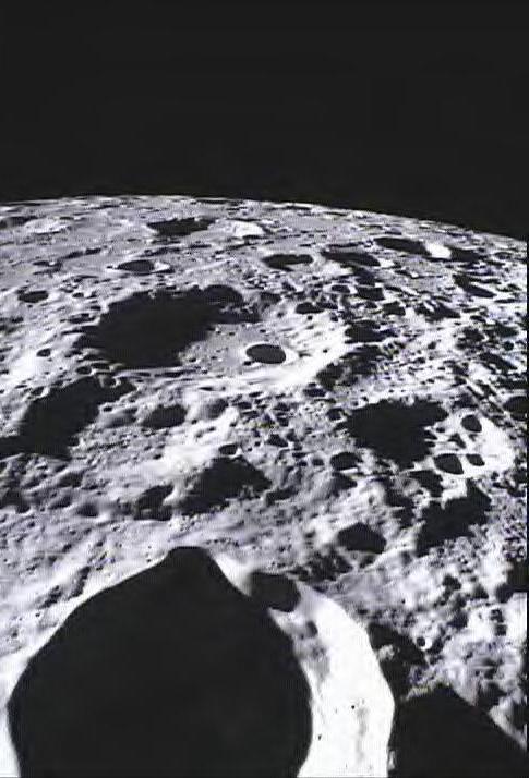
This image of the lunar surface was taken by NASA MoonKAM system onboard the Ebb spacecraft and shows Crater Poinsot located on the northern part of the moon far side.
Far Side of Moon Imaged by MoonKAM
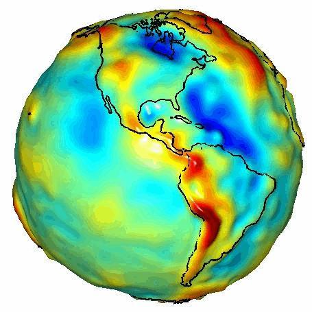
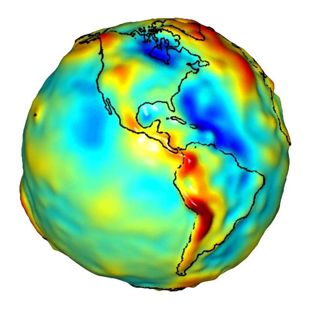
This visualization of a gravity model was created with data from NASA Gravity Recovery and Climate Experiment and shows variations in the gravity field across the Americas.
Global Gravity: North and South America
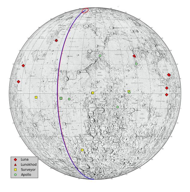
This graphic highlights locations on the moon NASA considers lunar heritage sites and the path NASA Gravity Recovery and Interior Laboratory spacecraft will take on their final flight.
Lunar Heritage Sites and GRAIL Final Mile
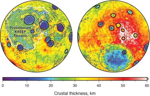
Global map of crustal thickness of the moon derived from gravity data obtained by NASA GRAIL spacecraft. The lunar near side is represented on the left hemisphere. The far side is represented in the right hemisphere.
Moon Crustal Thickness
Groundwater storage trends around the United States as measured by the NASA/German Aerospace Center Gravity Recovery and Climate Experiment GRACE satellites between 2003 and 2012.
GRACE Measures Groundwater Changes Across the U.S.