A NASA radar instrument has been successfully used to measure some of the fastest moving and most inaccessible glaciers in the world  -- in Chile's huge, remote Patagonia ice fields -- demonstrating a technique that could produce more accur…
Space Radar Image of San Rafael Glacier, Chile
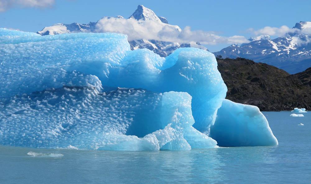
Calving front of the Upsala Glacier (Argentina). This glacier has been thinning and retreating at a rapid rate during the last decades – from 2006 to 2010, it receded 43.7 yards (40 meters) per year. During summer 2012, large calving events…
Glaciers and Sea Level Rise
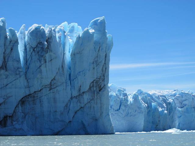
Calving front of the Perito Moreno Glacier (Argentina). Contrary to the majority of the glaciers from the southern Patagonian ice field, the Perito Moreno Glacier is currently stable. It is also one of the most visited glaciers in the world…
Glaciers and Sea Level Rise
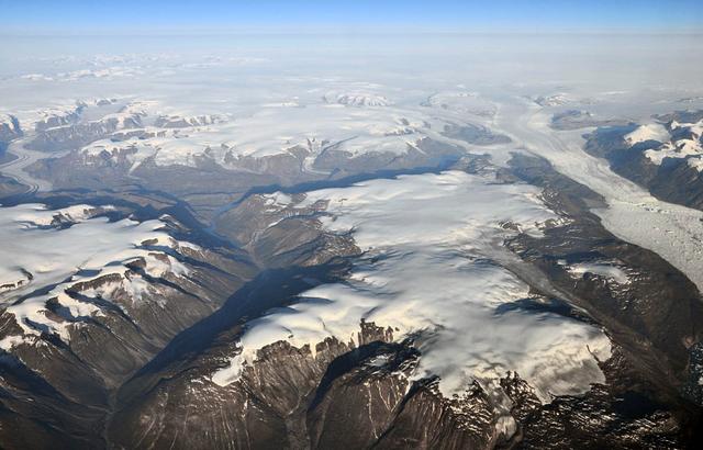
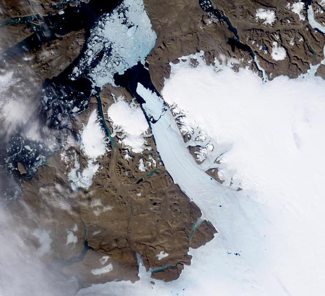
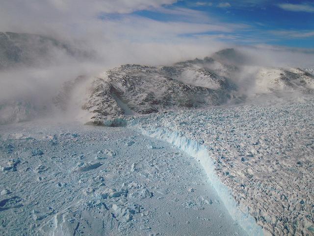
Peripheral glaciers and ice caps (isolated from the main ice sheet, which is seen in the upper right section of the image) in eastern Greenland.  To learn about the contributions of glaciers to sea level rise, visit: <a href="http://www.nas…
Glaciers and Sea Level Rise
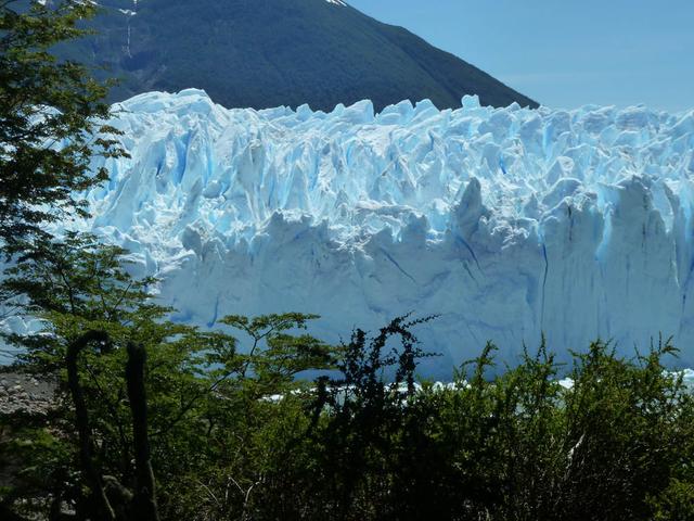
Calving front of the Perito Moreno Glacier (Argentina). Contrary to the majority of the glaciers from the southern Patagonian ice field, the Perito Moreno Glacier is currently stable. It is also one of the most visited glaciers in the world…
Glaciers and Sea Level Rise
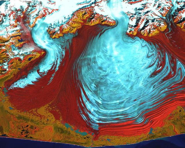
This image from the Advanced Spaceborne Thermal Emission and Reflection Radiometer (ASTER) instrument on NASA's Terra satellite covers an area of 55 by 40 kilometers (34 by 25 miles) over the southwest part of the Malaspina Glacier and Icy…
Malaspina Glacier, Alaska
The ice of a piedmont glacier spills from a steep valley onto a relatively flat plain, where it spreads out unconstrained like pancake batter. Elephant Foot Glacier in northeastern Greenland is an excellent example; it is particularly noted…
Malaspina Glacier, Alaska
NASA image acquired August 5, 2010  On August 5, 2010, an enormous chunk of ice, roughly 97 square miles (251 square kilometers) in size, broke off the Petermann Glacier, along the northwestern coast of Greenland. The Canadian Ice Service d…
Ice Island calves off Petermann Glacier
JPL engineer Andy Klesh lowers a robotic submersible into a moulin. Klesh and JPL's John Leichty used robots and probes to explore the Matanuska Glacier in Alaska this past July. Image Credit: NASA/JPL-Caltech
JPL-20170926-TECHf-0001-Robot Descends into Alaska Moulin
A new NASA-funded study has identified which glaciers in West Greenland are most susceptible to thinning in the coming decades by analyzing how they’re shaped. The research could help predict how much the Greenland Ice Sheet will contribute…
NASA-funded study says glacier shape matters and influences vulnerability to melting
On March 31, the P-3 departed Thule, Greenland. IceBridge teams flew a science transit flight to Kangerlussaq, Greenland, where missions will be based for the next several weeks before returning to Thule. Along the route, instruments survey…
Bye to Thule, For Now
Image taken 12/2/2000: The Lambert Glacier in Antarctica, is the world's largest glacier. The focal point of this image is an icefall that feeds into the Lambert glacier from the vast ice sheet covering the polar plateau. Ice flows like wat…
Icefall, Lambert Glacier, Antarctica
STS066-117-014 (3-14 Nov. 1994) --- Malaspina Glacier can be seen in this north-northeastern photograph taken in November, 1994. The glacier, located in the south shore of Alaska is a classic example of a piedmont glacier lying along the fo…
Malaspina Glacier, Alaska as seen from STS-66 Atlantis
On April 8, 2011, IceBridge flew a mission to coastal areas in southwest Greenland. Mountains and an open-water fjord surround one of the mission's targets, a small ice cap called Sukkertoppen Isflade.   Operation IceBridge, now in its thir…
SW Greenland Fjord and Mountain
The Cuernos del Paine mountains in Torres del Paine National Park, Chile, during NASA's AirSAR 2004 campaign. AirSAR 2004 is a three-week expedition in Central and South America by an international team of scientists that is using an all-we…
The Cuernos del Paine mountains in Torres del Paine National Park, Chile, during NASA's AirSAR 2004 campaign
Glacier Grey in front of the Cuernos del Paine mountains, photographed from Lago Grey (Grey Lake) during NASA's AirSAR 2004 campaign in Chile. AirSAR 2004 is a three-week expedition in Central and South America by an international team of s…
Glacier Grey in front of The Cuernos del Paine mountains, photographed from Lago Grey (Grey Lake) during NASA's AirSAR 2004 campaign in Chile
NASA image acquired September 6, 2010  The Matusevich Glacier flows toward the coast of East Antarctica, pushing through a channel between the Lazarev Mountains and the northwestern tip of the Wilson Hills. Constrained by surrounding rocks,…
Matusevich Glacier
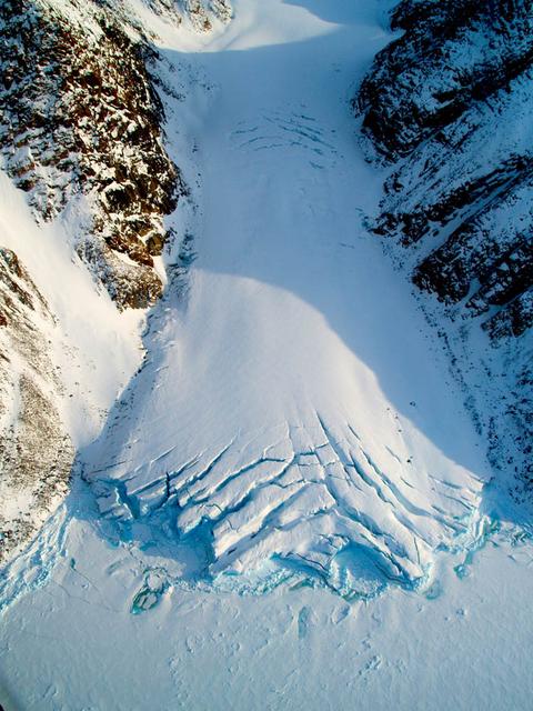
Aerial view of the Sverdrup Glacier, a river of ice that flows from the interior of the Devon Island Ice Cap (Canada) into the ocean.  To learn about the contributions of glaciers to sea level rise, visit: <a href="http://www.nasa.gov/topic…
Glaciers and Sea Level Rise
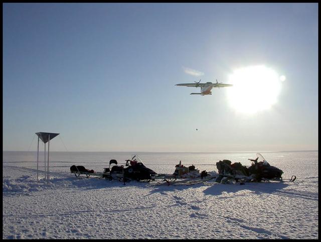
An airplane drops essential support on the Austfonna Ice Cap in Svalbard (Norwegian Arctic). The triangular structure is a corner reflector used as ground reference for airborne radar surveys.  To learn about the contributions of glaciers t…
Glaciers and Sea Level Rise
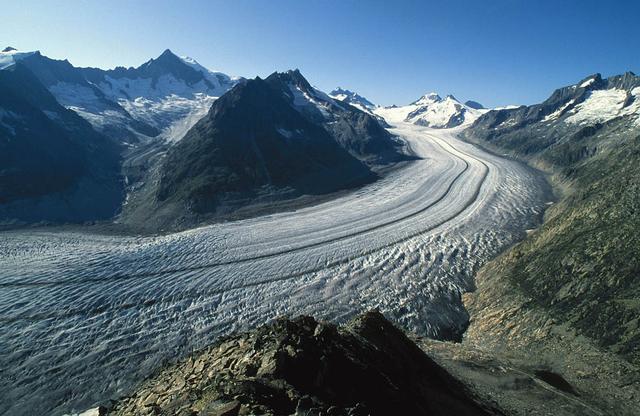
The Aletsch Glacier in Switzerland is the largest valley glacier in the Alps. Its volume loss since the middle of the 19th century is well-visible from the trimlines to the right of the image.  To learn about the contributions of glaciers t…
Glaciers and Sea Level Rise
NASA image acquired August 27, 2009  Like rivers of liquid water, glaciers flow downhill, with tributaries joining to form larger rivers. But where water rushes, ice crawls. As a result, glaciers gather dust and dirt, and bear long-lasting…
Susitna Glacier, Alaska
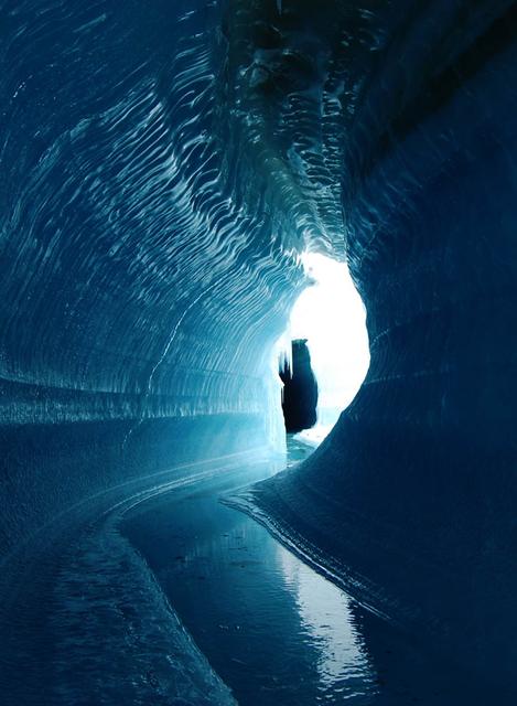
This ice cave in Belcher Glacier (Devon Island, Canada) was formed by melt water flowing within the glacier ice.  To learn about the contributions of glaciers to sea level rise, visit: <a href="http://www.nasa.gov/topics/earth/features/glac…
Glaciers and Sea Level Rise
New Zealand contains over 3,000 glaciers, most of which are in the Southern Alps on the South Island. Since 1890, the glaciers have been retreating, with short periods of small advances, as shown in this image from NASA Terra spacecraft. Th…
New Zealand Glaciers
In October 2016, the Khurdopin Glacier in Pakistan began a rapid surge after 20 years of little movement. By March, 2017, a large lake had formed in the Shimshal River, where the glacier had formed a dam. Fortunately, the river carved an ou…
Khurdopin Glacier, Pakistan
LISA SMITH, THE TRAINING TEAM LEAD IN MARSHALL'S MISSION OPERATIONS LAB, EXAMINES THE DRAWERS IN THE GLACIER MOCK-UP, A TRAINING VERSION OF A FREEZER ON THE INTERNATIONAL SPACE STATION INSTALLED IN THE MARSHALL CENTER'S LABORATORY TRAINING…
Lisa Smith in MSFC's Laboratory Training Complex
STS059-228-094 (9-20 April 1994) --- The spring thaw along the coast of the Gulf of Alaska has not touched the St. Elias Mountains, southeast of Yakutat Bay and Malaspina Glacier.  A prominent glacier flows from Mt. Fairweather (15,300 feet…
Earth observations taken during the STS-59 mission
SL2-05-380 (22 June 1973) --- Ottawa, in the province of Ontario, (46.5N, 75.5W) is the capital of Canada and can be seen near the bottom of this scene on the Ottawa River. The region shown lies within the Canadian Shield. The glaciated sur…
Ottawa, Quebec Province, Canada and Glaciated Landscape
STS-56 Earth observation shows of some of the highest mountain peaks in the world taken from Discovery, Orbiter Vehicle (OV) 103, as it passed over India and China. The top of the view shows one of the snow and ice-covered massifs in the gr…
STS-56 Earth observation of Karakorum Range of north India
STS059-S-072 (13 April 1994) --- This image is a false-color composite of Oetztal, Austria located in the Central Alps, centered at 46.8 degrees north latitude, and 10.70 degrees east longitude, at the border between Switzerland (top), Ital…
False-color composite of Oetztal, Austria
View of Glacier Grey from Lago Grey (Grey Lake), with the Cuernos del Paine mountains in the background, seen during NASA's AirSAR 2004 campaign in Chile. AirSAR 2004 is a three-week expedition in Central and South America by an internation…
View of Glacier Grey from Lago Grey (Grey Lake), with the Cuernos del Paine mountains in the background, seen during NASA's AirSAR 2004 campaign in Chile
Close-up view of Grey Glacier from Lago Grey (Grey Lake), taken during NASA's AirSAR 2004 campaign in Chile. AirSAR 2004 is a three-week expedition in Central and South America by an international team of scientists that is using an all-wea…
Close-up view of Grey Glacier from Lago Grey (Grey Lake), taken during NASA's AirSAR 2004 campaign in Chile
Small valley glacier exiting the Devon Island Ice Cap in Canada.  To learn about the contributions of glaciers to sea level rise, visit: <a href="http://www.nasa.gov/topics/earth/features/glacier-sea-rise.html" rel="nofollow">www.nasa.gov/t…
Glaciers and Sea Level Rise
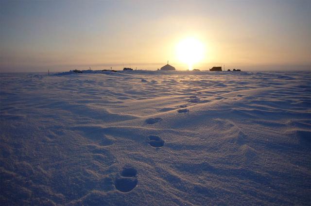
Summit camp on top of the Austfonna Ice Cap in Svalbard (Norwegian Arctic).  To learn about the contributions of glaciers to sea level rise, visit: <a href="http://www.nasa.gov/topics/earth/features/glacier-sea-rise.html" rel="nofollow">www…
Glaciers and Sea Level Rise
NASA image acquired August 11, 2010.  After breaking off the Petermann Glacier on August 5, 2010, a massive ice island floated slowly down the fjord toward the Nares Strait. The Advanced Spaceborne Thermal Emission and Reflection Radiometer…
Ice Island Calves off Petermann Glacier
Melt water ponded at surface in the accumulation zone of Columbia Glacier, Alaska, in July 2008.  To learn about the contributions of glaciers to sea level rise, visit: <a href="http://www.nasa.gov/topics/earth/features/glacier-sea-rise.htm…
Glaciers and Sea Level Rise
A chunk of glacier was threatening to fall into an Andean lake and cause major flooding in a Peruvian city of 60,000. A fissure has appeared in the glacier that feeds the Lake Palcacocha near the city of Huaraz, 270 km north of Lima. If the…
Huaraz, Peru
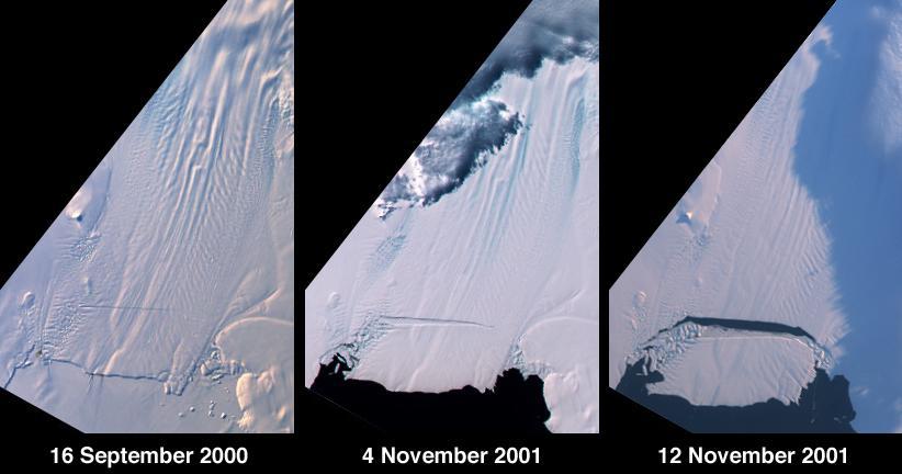
A large tabular iceberg (42 kilometers x 17 kilometers) broke off Pine Island Glacier, West Antarctica (75ºS latitude, 102ºW longitude) sometime between November 4 and 12, 2001. Images of the glacier were acquired by the Multi-angle Imaging…
Birth of a Large Iceberg in Pine Island Bay, Antarctica
An Earth-monitoring instrument aboard NASA's Terra satellite is keeping a close eye on a potential glacial disaster in the making in Peru's spectacular, snow-capped Cordillera Blanca (White Mountains), the highest range of the Peruvian Ande…
NASA Keeps Watch on a Potential Disaster in the Icy Andes
Aletsch Glacier, the largest glacier of Europe, covers more than 120 square kilometers (more than 45 square miles) in southern Switzerland. At its eastern extremity lies a glacierlake, Mdrjelensee (2,350 meters/7,711 feet above sea level).…
Aletsch Glacier, Switzerland
On April 11, 2011, IceBridge finally got the clear weather necessary to fly over glaciers in southeast Greenland. But with clear skies came winds of up to 70 knots, which made for a bumpy ride over the calving front of glaciers like Gyldenl…
Gyldenlove Glacier
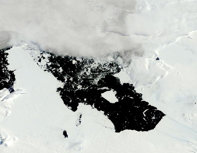
The voyage of Iceberg B-31 continued in January, 2014 as the giant iceberg drifted over the frigid waters of Pine Island Bay and widened the gap between the newly-calved iceberg and the “mother” glacier.  Between November 9 and 11, 20143 a…
Iceberg from Pine Island Glacier, Antarctica
NASA image captured August 31, 2000  The tongue of the Malaspina Glacier, the largest glacier in Alaska, fills most of this image. The Malaspina lies west of Yakutat Bay and covers 1,500 sq. MI (3,880 sq. km).  Credit: NASA/Landsat  <b><a h…
Malaspina Glacier
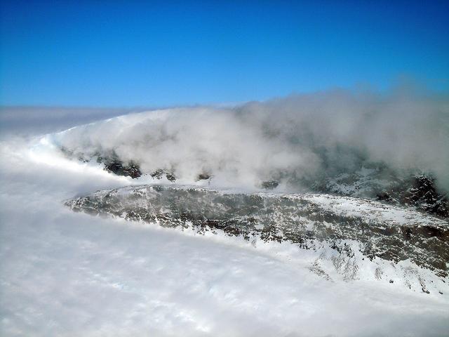
On April 11, 2011, IceBridge finally got the clear weather necessary to fly over glaciers in southeast Greenland, but with clear skies came winds of up to 70 knots. What looks like clouds is actually wind-blown snow. The data could help sci…
Windblown Snow
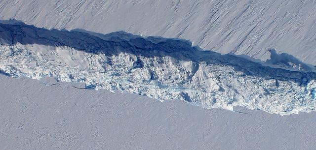
A close-up image of the crack spreading across the ice shelf of Pine Island Glacier shows the details of the boulder-like blocks of ice that fell into the rift when it split. For most of the 18-mile stretch of the crack that NASA’s DC-8 fle…
Newly Found Crack Across the Pine Island Glacier
STS001-12-350 (12-14 April 1981) --- India and China, the Ladokh and Zaskar Ranges of the Great Himalaya are clearly etched by snow and shadow. A detailed view shows the glaciation process over a wide area. Photo credit: NASA
Himalayan Mountain Range
Glacier Grey view from Lago Grey (Grey Lake), photographed during NASA's AirSAR 2004 campaign in Chile. Land visible in this photo was covered by glacier just 6 years earlier. AirSAR 2004 is a three-week expedition in Central and South Amer…
Glacier Grey view from Lago Grey (Grey Lake), photographed during NASA's AirSAR 2004 campaign in Chile
A cave in Glacier Grey in Torres del Paine National Park, seen during NASA's AirSAR 2004 campaign in Chile. AirSAR 2004 is a three-week expedition in Central and South America by an international team of scientists that is using an all-weat…
A cave in Glacier Grey in Torres del Paine National Park, seen during NASA's AirSAR 2004 campaign in Chile
The Cuernos del Paine mountains in Torres del Paine National Park in Chile, photographed during NASA's AirSAR 2004 campaign. AirSAR 2004 is a three-week expedition in Central and South America by an international team of scientists that is…
The Cuernos del Paine mountains in Torres del Paine National Park in Chile, photographed during NASA's AirSAR 2004 campaign