POSSIBLE METEORITE SAMPLES COLLECTED ON RECENT FIELD TRIP TO BANKHEAD NATIONAL FOREST, ALABAMA
1300145
Ceremonial Pulaski tools are positioned in front of a new memorial marker Nov. 1 on the Merritt Island National Wildlife Refuge in Florida. During a joint ceremony, the Spaceport Integration Team and its partners were presented with the pre…
Pulaski Award Ceremony
From left, Jon Wallace, deputy fire coordinator, U.S. Fish and Wildlife Service Southeast Region, Atlanta, Georgia; Chris Wilcox, U.S. Fish and Wildlife chief, Fire Management, National Interagency Fire Center, Boise, Idaho; and Kelvin Mann…
Pulaski Award Ceremony
From left, Jon Wallace, deputy fire coordinator, U.S. Fish and Wildlife Service Southeast Region, Atlanta, Georgia; Chris Wilcox, U.S. Fish and Wildlife chief, Fire Management, National Interagency Fire Center, Boise, Idaho; and John Fish,…
Pulaski Award Ceremony
Layne Hamilton, manager of the Merritt Island National Wildlife Refuge, welcomes guests to a ceremony held Nov. 1 on the refuge in Florida. During the joint ceremony, the Spaceport Integration Team and its partners were presented with the p…
Pulaski Award Ceremony
From left, Jon Wallace, deputy fire coordinator, U.S. Fish and Wildlife Service Southeast Region, Atlanta, Georgia; Chris Wilcox, U.S. Fish and Wildlife chief, Fire Management, National Interagency Fire Center, Boise, Idaho; and Mark Scholl…
Pulaski Award Ceremony
NASA’s B200 King Air aircraft – based at NASA’s Armstrong Flight Research Center in Edwards, California – ascends to support a prescribed burn in Geneva State Forest, about 100 miles south of Montgomery, Alabama, on March 17, 2025. The effo…
NASA’s B200 Takes Flight for Wildfire Mission
STS062-85-095 (4-18 March 1994) --- Gatun Lake and the forested Panama Canal Zone can be seen in this north northwest-looking low oblique photograph obtained in March 1994.  The shipping chanel of the canal is 82.4 kilometers (51.2 miles) l…
Panama Canal Zone as seen from STS-62
1990 Group 13 Astronaut Candidate (ASCAN) Susan J. Helms gathers pine branches to create bedding under a tent she has constructed from a parachute. Helms, along with her classmates, is participating in wilderness survival training at Fairch…
ASCAN Helms sets up tent during survival training at Fairchild AFB
Mt. Pinatubo on the island of Luzon (15.0N, 120.0E) erupted catastrophically in June 1991 after over 600 years of inactivity. In this vertical view, the full extent of the eruption is obvious. Thick layers of ash completely surrounds the cr…
Mt. Pinatubo Volcano - Post Eruption, Luzon, Philippines
STS059-S-068 (13 April 1994) --- This false-color L-Band image of the Manaus region of Brazil was acquired by the Spaceborne Imaging Radar-C and X-Band Synthetic Aperture Radar (SIR-C/X-SAR) aboard the Space Shuttle Endeavour on orbit 46 of…
False-color L-band image of Manaus region of Brazil
NASA's DC-8 flying laboratory takes off from Juan Santamaria International Airport in San Jose, Costa Rica, on NASA's AirSAR 2004 campaign. AirSAR 2004 Mesoamerica is a three-week expedition by an international team of scientists that uses…
NASA's DC-8 flying laboratory takes off from Juan Santamaria International Airport in San Jose, Costa Rica, on NASA's AirSAR 2004 campaign
Pre-Columbian archaeological ruins are revealed through Costa Rican rain forest in this photo taken during NASA's AirSAR 2004 Mesoamerica campaign. AirSAR 2004 Mesoamerica is a three-week expedition by an international team of scientists th…
Pre-Columbian archaeological ruins are revealed through Costa Rican rain forest in this photo taken during NASA's AirSAR 2004 campaign
Pre-Columbian archaeological ruins are revealed through Costa Rican rain forest in this photo taken during NASA's AirSAR 2004 Mesoamerica campaign. AirSAR 2004 Mesoamerica is a three-week expedition by an international team of scientists th…
Pre-Columbian archaeological ruins are revealed through Costa Rican rain forest in this photo taken during NASA's AirSAR 2004 campaign
This photograph shows a stream in the La Selva region of the Costa Rican rain forest, taken during NASA's AirSAR 2004 Mesoamerica campaign. AirSAR 2004 Mesoamerica is a three-week expedition by an international team of scientists that will…
This photograph shows a stream in the La Selva region of the Costa Rican rain forest, taken during NASA's AirSAR 2004 Mesoamerica campaign
NASA Dryden Mission Manager Walter Klein passes out Airborne Science stickers and lithographs to underprivileged school children that visited the airport on Monday March 8, 2004. In spanish, he explained to them the mission of the DC-8 AirS…
DFRC Mission Manager Walter Klein passes out stickers and lithographs to underprivileged Costa Rican school children that visited the airport on Monday March 8, 2004
Pre-Columbian archaeological ruins are revealed through Costa Rican rain forest in this photo taken during NASA's AirSAR 2004 Mesoamerica campaign. AirSAR 2004 Mesoamerica is a three-week expedition by an international team of scientists th…
Pre-Columbian archaeological ruins are revealed through Costa Rican rain forest in this photo taken during NASA's AirSAR 2004 campaign
NASA Dryden Mission Manager Walter Klein passes out Airborne Science stickers and lithographs to underprivileged school children that visited the airport on Monday March 8, 2004. In spanish, he explained to them the mission of the DC-8 AirS…
DFRC Mission Manager Walter Klein passes out stickers and lithographs to underprivileged Costa Rican school children that visited the airport on Monday March 8, 2004
STS043-151-159 (2-11 August 1991) --- This photograph looks westward over the high plateau of the southern Peruvian Andes west and north of Lake Titicaca (not in field of view). Lima, Peru lies under the clouds just north of the clear coast…
Andes Altiplano, South America
Firefighters prepare to place ceremonial Pulaski tools by a new memorial marker Nov. 1 on the Merritt Island National Wildlife Refuge in Florida. During a joint ceremony, the Spaceport Integration Team and its partners were presented with t…
Pulaski Award Ceremony
STS049-91-079 (7 - 16 May 1992) --- This 70mm frame, photographed from the Earth-orbiting Space Shuttle Endeavour, features a dendritic drainage pattern in Zaire.  Cleared pasture land shows light green in this color photograph, in contrast…
Uele River, Cleared Pasture Lands, Zaire, Africa
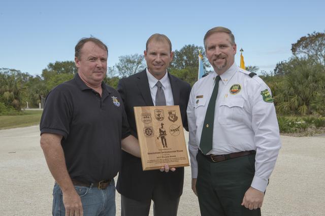
NASA's Kennedy Space Center Associate Director Kelvin Manning, left, and representatives from Kennedy's Spaceport Integration and Services pose for a portrait following a ceremony Nov. 1 on the Merritt Island National Wildlife Refuge in Flo…
Pulaski Award Ceremony
This is an image of equatorial Africa, centered on the equator at longitude 15degrees east. This image is a mosaic of almost 4,000 separate images obtained in 1996 by the L-band imaging radar onboard the Japanese Earth Resources Satellite.…
Radar Mosaic of Africa
From left, Col. Z. Walter Jackim, vice commander, 45th Space Wing, Cape Canaveral Air Force Station; Michael Good, assistant fire management officer, Merritt Island National Wildlife Refuge; John Fish, chief, Florida Forest Service; Mark Sc…
Pulaski Award Ceremony
The prestigious 2017 Pulaski Award is on display near a new memorial marker on the Merritt Island National Wildlife Refuge in Florida. During a joint ceremony, the Spaceport Integration Team and its partners were presented with the award an…
Pulaski Award Ceremony
The city of Sapporo on the northernmost of the Japanese Home Island of Hokkaido (43.5N, 141.5E), host to the 1986 Winter Olympic Games is situated along the margin of a large valley which extends across the island from the Sea of Japan to t…
Sapporo, Hokkaido, Japan
1990 Group 13 Astronaut Candidates (ASCANs) (left to right) Bernard J. Harris, Jr, Susan J. Helms, and William S. McArthur, Jr open dehydrated food packages during wilderness survival training at Fairchild Air Force Base (AFB) in Spokane, W…
ASCANs Harris, Helms, and McArthur during survival training at Fairchild AFB
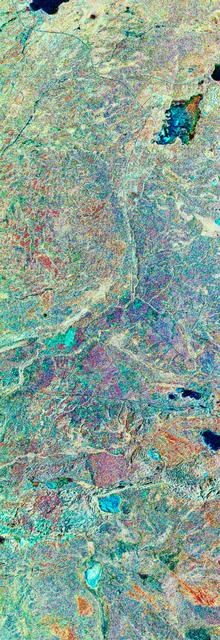
STS059-S-039 (11 April 1994) --- This is a false-color composite of Prince Albert, Canada, centered at 53.91 north latitude and 104.69 west longitude.  This image was acquired by the Spaceborne Imaging Radar-C and X-Band Synthetic Aperture…
False-color composite image of Prince Albert, Canada
Dense rain forest in the La Selva region of Costa Rica. AirSAR 2004 Mesoamerica is a three-week expedition by an international team of scientists that uses an all-weather imaging tool, called the Airborne Synthetic Aperture Radar (AirSAR) w…
Dense rain forest in the La Selva region of Costa Rica
A Cal Fire S2-T airtanker follows a U.S. Forest Service King Air 200 during an aerial attack on a simulated wildfire, Tuesday, May 4, 2021 as Cal Fire conducts aerial fire fighting training exercises near Redding, California.  STEReO, the S…
STEReO Field Testing
This photograph shows a stream in the La Selva region of the Costa Rican rain forest, taken during NASA's AirSAR 2004 campaign. AirSAR 2004 Mesoamerica is a three-week expedition by an international team of scientists that uses an all-weath…
This photograph shows a stream in the La Selva region of the Costa Rican rain forest, taken during NASA's AirSAR 2004 campaign
DC-8 Quality Inspector Scott Silver signs documents while Acting Crew Chief Mike Bereda looks on prior to a DC-8 AirSAR flight in Costa Rica. AirSAR 2004 Mesoamerica is a three-week expedition by an international team of scientists that use…
DC-8 Quality Inspector Scott Silver signs documents while Acting Crew Chief Mike Bereda looks on prior to a DC-8 AirSAR flight in Costa Rica
Pre-Columbian archaeological ruins are revealed through Costa Rican rain forest in this photo taken during NASA's AirSAR 2004 Mesoamerica campaign. AirSAR 2004 Mesoamerica is a three-week expedition by an international team of scientists th…
Pre-Columbian archaeological ruins are revealed through Costa Rican rain forest in this photo taken during NASA's AirSAR 2004 campaign
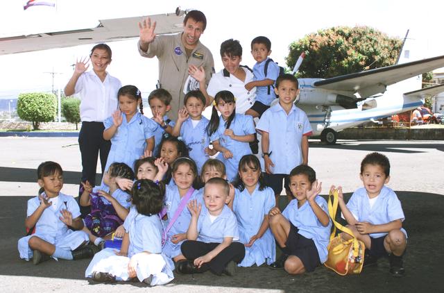
NASA Dryden Mission Manager Walter Klein poses with school children that visited the airport during AirSAR 2004. In spanish, he explained to them the mission of the DC-8 AirSAR 2004 Mesoamerican campaign in Costa Rica. AirSAR 2004 Mesoameri…
NASA Dryden Mission Manager Walter Klein poses with school children that visited the airport during AirSAR 2004
The large field patterns in this view of the Rio Sao Francisco basin, Brazil, South America, (11.5S, 43.5W) indicate a commercial agriculture venture; family subsistence farms are much smaller and laid out in different patterns. Land cleari…
Agriculture, Rio Sao Francisco, Brazil, South America
A presentation of colors by the U.S. Fish and Wildlife Service honor guard opened a ceremony Nov. 1 on the Merritt Island National Wildlife Refuge in Florida. During the joint ceremony, the Spaceport Integration Team and its partners were p…
Pulaski Award Ceremony
A presentation of colors opened a ceremony Nov. 1 on the Merritt Island National Wildlife Refuge in Florida. During the joint ceremony, the Spaceport Integration Team and its partners were presented with the prestigious 2017 Pulaski Award a…
Pulaski Award Ceremony
Ceremonial Pulaski tools are positioned in front of a new memorial marker Nov. 1 on the Merritt Island National Wildlife Refuge in Florida. During a joint ceremony, the Spaceport Integration Team and its partners were presented with the pre…
Pulaski Award Ceremony
Firefighters place ceremonial Pulaski tools by a new memorial marker Nov. 1 on the Merritt Island National Wildlife Refuge in Florida. During a joint ceremony, the Spaceport Integration Team and its partners were presented with the prestigi…
Pulaski Award Ceremony
SL2-04-018 (June 1973) --- A vertical view of the Arizona-Utah border area showing the Colorado River and Grand Canyon photographed from the Skylab 1/2 space station in Earth orbit. This picture was taken by one of the six lenses of the Ite…
Lake Powell, Colorado River, Utah and Grand Canyon, Arizona
STS060-87-087 (3-11 Feb 1994) --- Lake Baikal, in southeastern Siberia, is the largest freshwater lake in the world by volume, holding nearly 20 per cent of the world's fresh water.  Lake Baikal is a biospheric reserve of high international…
Lake Baikal, Russia as seen by STS-60
NASA's DC-8 flying laboratory seen at sunset after a flight supporting the AirSAR 2004 Mesoamerica campaign. AirSAR 2004 Mesoamerica is a three-week expedition by an international team of scientists that uses an all-weather imaging tool, ca…
NASA's DC-8 flying laboratory seen at sunset after a flight supporting the AirSAR 2004 Mesoamerica campaign
NASA's DC-8 flying laboratory seen at sunset after a flight supporting the AirSAR 2004 Mesoamerica campaign. AirSAR 2004 Mesoamerica is a three-week expedition by an international team of scientists that uses an all-weather imaging tool, ca…
NASA's DC-8 flying laboratory seen at sunset after a flight supporting the AirSAR 2004 Mesoamerica campaign
A spider photographed during NASA's AirSAR 2004 Mesoamerica campaign in the La Selva region of the Costa Rican rain forest. AirSAR 2004 Mesoamerica is a three-week expedition by an international team of scientists that uses an all-weather i…
A spider photographed during NASA's AirSAR 2004 Mesoamerica campaign in the La Selva region of the Costa Rican rain forest
STS059-S-079 (18 April 1994) --- This is a false-color, three frequency image of Prince Albert, Canada, centered at 53.91 north latitude and 104.69 west longitude.  It was produced using data from the X-Band, C-Band and L-Band radars that c…
Three frequency false-color image of Prince Albert, Canada
A plant photographed in the La Selva region of the Costa Rican rain forest as part of NASA's AirSAR 2004 Mesoamerica campaign. AirSAR 2004 Mesoamerica is a three-week expedition by an international team of scientists that will use an all-we…
A plant photographed in the La Selva region of the Costa Rican rain forest as part of NASA's AirSAR 2004 Mesoamerica campaign
NASA Dryden DC-8 maintenance crew members inspect the aircraft prior to take-off. L-R; Scott Silver, Paul Ristrim and Mike Lakowski. AirSAR 2004 Mesoamerica is a three-week expedition by an international team of scientists that uses an all-…
NASA Dryden DC-8 maintenance crew members inspect the aircraft prior to take-off for an AirSAR 2004 flight
A lizard photographed in the La Selva region of the Costa Rican rain forest as part of NASA's AirSAR 2004 Mesoamerica campaign. AirSAR 2004 Mesoamerica is a three-week expedition by an international team of scientists that will use an all-w…
A lizard photographed in the La Selva region of the Costa Rican rain forest as part of NASA's AirSAR 2004 Mesoamerica campaign