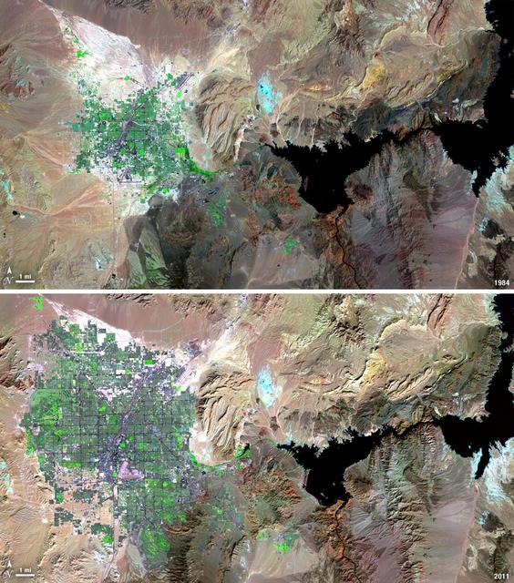
Over the years of the Landsat program, the desert city of Las Vegas has gone through a massive growth spurt. The outward expansion of the city over the last quarter of a century is shown here with two false-color Landsat 5 images (August 3,…
Landsat View: Las Vegas, Nevada
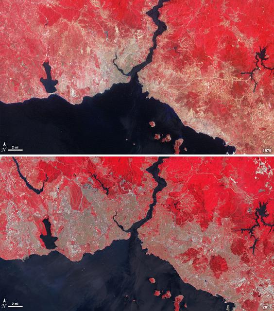
Istanbul has been a bustling trade city for thousands of years. In this 1975 image, taken by Landsat, the city centers on the Golden Horn the estuary that flows into the Bosporus Straight at the center of the scene. Shown in false color, ve…
Landsat View: Istanbul, Turkey
Over the last 25 years, Chandler, Arizona has traded its grid of fields for a grid of streets. Founded in 1912 on cotton, grains, alfalfa, and ostrich farms, brown and green irrigated fields still dominate the region southeast of Phoenix in…
Landsat View: Chandler, Arizona
This nearly cloud-free image of Iceland was captured by the MODIS instrument on board the Terra spacecraft on  04/15/2015 at 13:00 UTC.  <b><a href="http://www.nasa.gov/audience/formedia/features/MP_Photo_Guidelines.html" rel="nofollow">NAS…
Cloud-Free View of Iceland
Today, April 22, 2014 is Earth Day, and what better way to celebrate than taking a look at our home planet from space.  NOAA's GOES-East satellite captured this stunning view of the Americas on Earth Day, April 22, 2014 at 11:45 UTC/7:45 a.…
Satellite View of the Americas on Earth Day
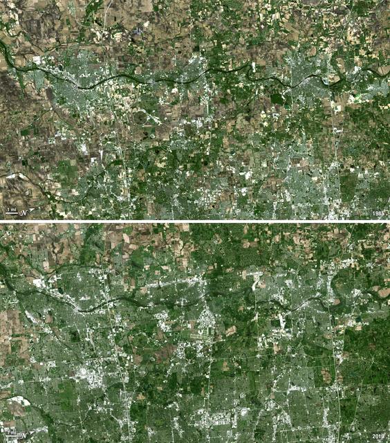
Forty miles west of downtown Chicago, the Fox River meanders its way through what has become the westernmost reaches of metropolitan Chicago, where the sprawling metropolis meets the hinterlands. While Chicago itself has seen a seven percen…
Landsat View: Western Suburbs of Chicago, Illinois
GOES 12 satellite image showing earth on March 25, 2010 6:45 AM EDT.  <b><a href="http://goes.gsfc.nasa.gov/" rel="nofollow">Credit: NOAA/NASA GOES Project</a><b>  <b><a href="http://www.nasa.gov/centers/goddard/home/index.html" rel="nofoll…
NASA GOES-12 Full Disk view March 25, 2010
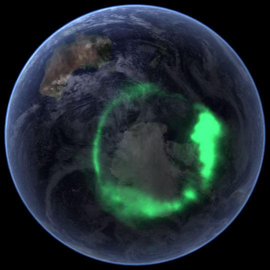
NASA file image acquired September 11, 2005  <b>To view a video of this event go here: <a href="http://www.flickr.com/photos/gsfc/6257608714">www.flickr.com/photos/gsfc/6257608714</a></b>  From space, the aurora is a crown of light that cir…
NASA's IMAGE Spacecraft View of Aurora Australis from Space
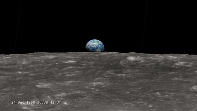
<b>Join NASA's Google+ Hangout on Friday, December 20th 2:00 - 3:00 PM (EST) at <a href="http://go.nasa.gov/18S2TbC" rel="nofollow">go.nasa.gov/18S2TbC</a> </b>  It was 45 years ago, on December 24, 1968 when Apollo 8 astronauts captured 'E…
NASA Google+ Hangout: 'Earthrise' A New Visualization - 45th Anniversary of Apollo 8 Viewing Earth from Space
Africa is front and center in this image of Earth taken by a NASA camera on the Deep Space Climate Observatory (DSCOVR) satellite. The image, taken July 6 from a vantage point one million miles from Earth, was one of the first taken by NASA…
'EPIC' View of Africa and Europe from a Million Miles Away
art002e00444 (April 3, 2026) - An illuminated sliver of Earth set against the blackness of space is seen through the window of the Orion spacecraft in this photograph from the Artemis II crew on the third day of their journey to the Moon.
A Crescent Earth
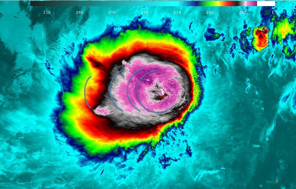
The first tropical cyclone in the Northern Indian Ocean this season has been getting better organized as seen in NASA satellite imagery. Tropical Cyclone Mahasen is projected to track north through the Bay of Bengal and make landfall later…
Suomi NPP Satellite Views of Tropical Cyclone Mahasen in the Northern Indian Ocean
GOES 12 satellite image showing the US east coast on March 22, 2010 6:45 AM EDT.  <b><a href="http://goes.gsfc.nasa.gov/" rel="nofollow">Credit: NOAA/NASA GOES Project</a><b>  <b><a href="http://www.nasa.gov/centers/goddard/home/index.html"…
NASA GOES-12 East Coast view March 22, 2010
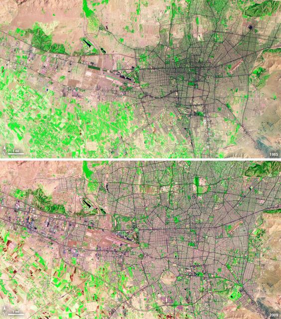
Between 1985 and 2009, the population of Tehran, Iran, grew from six million to just over seven million. The city's growth was spurred largely by migration from other parts of the country. In addition to being the hub of government and asso…
Landsat View: Tehran, Iran
NASA image acquired November 2,  2011  The Moderate Resolution Imaging Spectroradiometer (MODIS) instrument on NASA's Terra satellite captured this image of the Knox, Budd Law Dome, and Sabrina Coasts, Antarctica on November 2, 2011 at 01:4…
NASA Satellite View of Antarctica
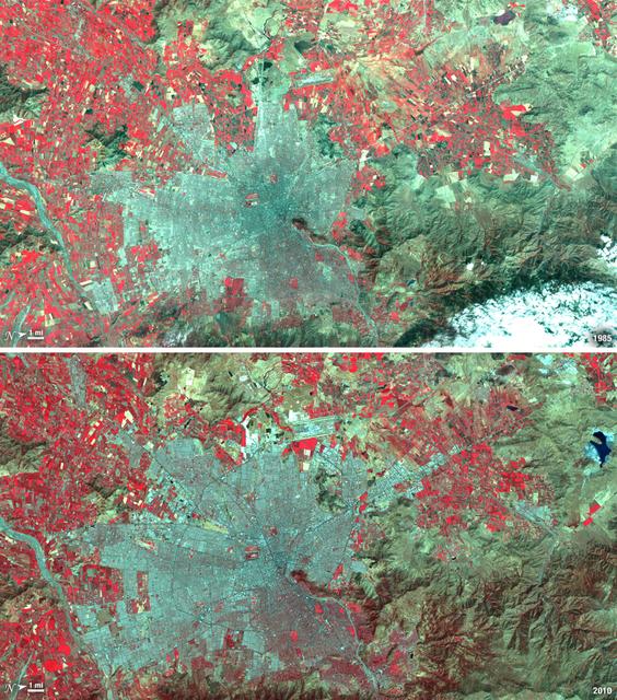
Santiago, Chile, ranks among the world's fastest growing cities. Chile is South America's fifth largest economy with strong export and tourism markets. More than a third of Chile's population lives in Santiago as of 2009. Taken on January 9…
Landsat View: Santiago, Chile
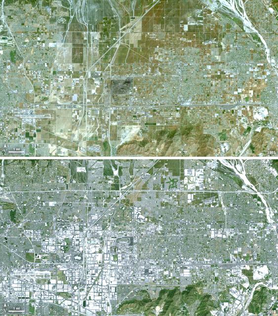
Thirty-five miles due east of downtown Los Angeles lies the city of Ontario, California. In 1881 two Canadian brothers established the town, naming it after their native city. By 1891 Ontario, Calif., was incorporated as a city. The farming…
Landsat View: Ontario, California
NASA GOES 13 satellite image showing earth on May 28, 2010 11:45 UTC.  <b><a href="http://goes.gsfc.nasa.gov/" rel="nofollow">Credit: NOAA/NASA GOES Project</a><b>  <b><a href="http://www.nasa.gov/centers/goddard/home/index.html" rel="nofol…
NASA GOES-13 Full Disk view of Earth May 28, 2010
On August 25, 2013, the Moderate Resolution Imaging Spectroradiometer (MODIS) on NASA’s Terra satellite acquired this image of the drought-fueled Rim fire burning in central California, near Yosemite National Park.  Red outlines indicate ho…
Satellite View of Rim Fire On August 25, 2013
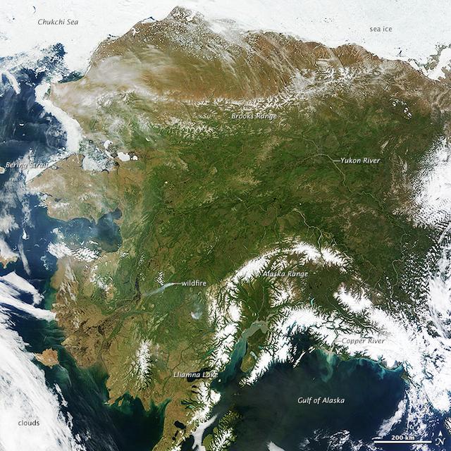
On most days, relentless rivers of clouds wash over Alaska, obscuring most of the state’s 6,640 miles (10,690 kilometers) of coastline and 586,000 square miles (1,518,000 square kilometers) of land. The south coast of Alaska even has the du…
Rare Clear View of Alaska [high res]
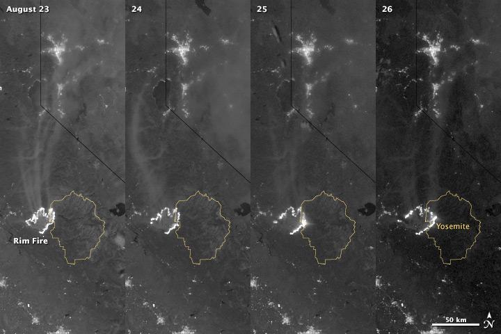
The winter of 2013 was among the driest on record for California, setting the stage for an active fire season. By August 26, the Rim Fire had made its way into the record books. At just 15 percent contained, the fire is now the 13th largest…
Nighttime View of California’s Rim Fire
ISS038-E-042992 (10 Feb. 2014) --- One of the Expedition 38 crew members aboard the International Space Station downlinked this vertical 600mm night view of Sochi, Russia, which clearly shows the site of the 2014 Winter Olympics while they…
Night View of Sochi During Olympics
NASA GOES-11 satellite image showing the US west coast on March 24, 2010 1:45 PM EDT.  <b><a href="http://goes.gsfc.nasa.gov/" rel="nofollow">Credit: NOAA/NASA GOES Project</a><b>  <b><a href="http://www.nasa.gov/centers/goddard/home/index.…
NASA GOES-11 West Coast view March 24, 2010
GOES 11 satellite image showing earth on March 26, 2010 8:00 AM EDT.  <b><a href="http://goes.gsfc.nasa.gov/" rel="nofollow">Credit: NOAA/NASA GOES Project</a><b>  <b><a href="http://www.nasa.gov/centers/goddard/home/index.html" rel="nofoll…
NASA GOES-11 Full Disk view March 26, 2010
January 25, 2012  <b>*Updated February 2, 2012: According to Flickr, &quot;The western hemisphere Blue Marble 2012 image has rocketed up to over 3.1 million views making it one of the all time most viewed images on the site after only one w…
Most Amazing High Definition Image of Earth - Blue Marble 2012
art002e000180 (April 1, 2026) - This black and white image of Earth was captured by the optical navigation sensor on the exterior of the Orion spacecraft on the first day of the Artemis II mission, as the four astronauts inside were traveli…
Orion Looks Back at Earth
NOAA's GOES-East satellite captured this stunning view of the Americas on 12.13.14, December 13, 2014 at 17:45 UTC. The data from GOES-East was made into an image by the NASA/NOAA GOES Project at NASA's Goddard Space Flight Center in Greenb…
View of the Americas on 12.13.14
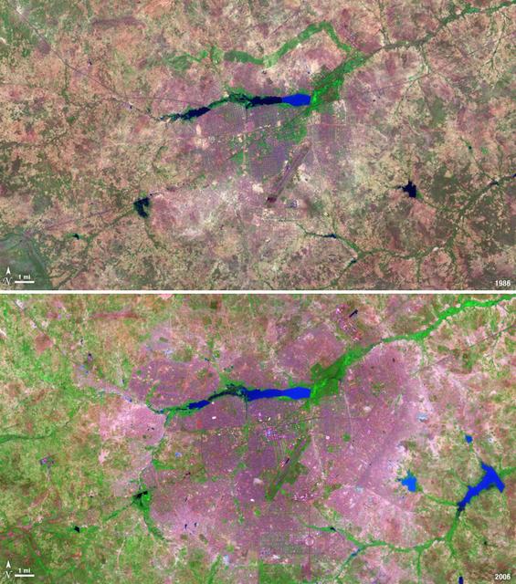
The landlocked western African nation of Burkina Faso experienced a 200 percent increase in urban population between 1975 and 2000. As a result, the area of the capital city Ouagadougou grew 14-fold during this period.   These Landsat image…
Landsat View: Ouagadougou, Burkina Faso
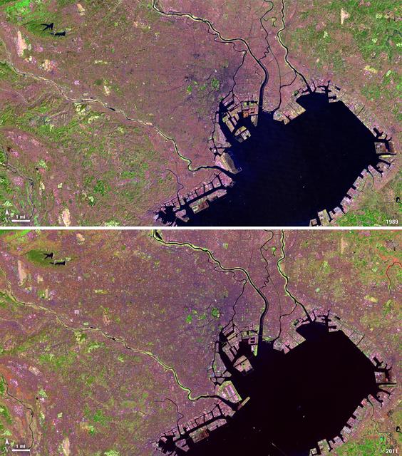
Tokyo is the world’s largest metropolitan region, home to nearly 37 million people. During the past two decades, Tokyo’s population has grown by more than 7 million. The city’s growth has continued despite Japan’s overall stagnating populat…
Landsat View: Tokyo, Japan
This composite image of southern Africa and the surrounding oceans was captured by six orbits of the NASA/NOAA Suomi National Polar-orbiting Partnership spacecraft on April 9, 2015, by the Visible Infrared Imaging Radiometer Suite (VIIRS) i…
A Sky View of Earth From Suomi NPP
NASA image acquired October 28, 2012  <b>For the latest info from NASA on Hurricane Sandy go to: <a href="http://1.usa.gov/Ti5SgS" rel="nofollow">1.usa.gov/Ti5SgS</a></b>  This image of Hurricane Sandy was acquired by the Visible Infrared I…
Hurricane Sandy Viewed in the Dark of Night
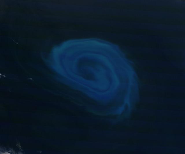
NASA image acquired December 26, 2011  Off the coast of South Africa, near where the South Atlantic meets the Southern Indian Ocean, a massive summer phytoplankton bloom colored the waters with a swirl of turquoise, green and white in late…
Phytoplankton bloom off South Africa
The winter of 2013 was among the driest on record for California, setting the stage for an active fire season. By August 26, the Rim Fire had made its way into the record books. At just 15 percent contained, the fire is now the 13th largest…
Nighttime View of California’s Rim Fire
On most days, relentless rivers of clouds wash over Alaska, obscuring most of the state’s 6,640 miles (10,690 kilometers) of coastline and 586,000 square miles (1,518,000 square kilometers) of land. The south coast of Alaska even has the du…
Rare Clear View of Alaska [annotated]
NASA GOES 12 satellite image showing earth on March 30, 2010 7:45 AM EDT.  <b><a href="http://goes.gsfc.nasa.gov/" rel="nofollow">Credit: NOAA/NASA GOES Project</a><b>  <b><a href="http://www.nasa.gov/centers/goddard/home/index.html" rel="n…
NASA GOES-12 Full Disk view March 30, 2010
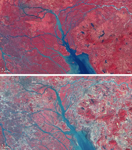
In 1979, China established two special economic zones around the Pearl River Delta, north of Hong Kong. This image, taken by Landsat 3 on October 19, 1973, shows that the region was rural when the zone was established. Plant-covered land, w…
Landsat View: Pearl River Delta, China
GOES 12 satellite image showing earth on March 16, 2010 6:45 AM EDT.  <b><a href="http://goes.gsfc.nasa.gov/" rel="nofollow">Credit: NOAA/NASA GOES Project</a><b>  <b><a href="http://www.nasa.gov/centers/goddard/home/index.html" rel="nofoll…
GOES 12 Full Disk view March 16, 2010
No more images