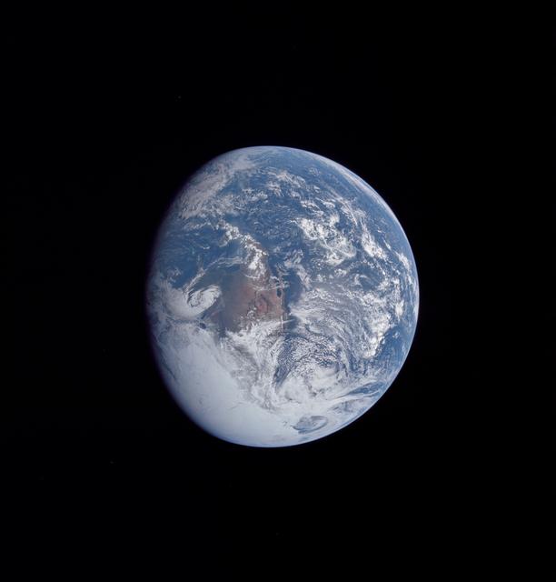
AS17-148-22742 (7-19 Dec. 1972) --- Most of Australia (center) and part of Antarctica are visible in this photo of a three-quarters Earth, recorded with a 70mm handheld Hasselblad camera using a 250mm lens. The three astronauts aboard the C…
View of the Earth seen by the Apollo 17 crew traveling toward the moon
S62-01287 (21 July 1961) --- Earth observation take during the Mercury-Redstone 4 (MR-4) spaceflight. Photo credit: NASA
Earth Observation - Mercury-Redstone (MR)-4 Flight
AS16-118-18885 (16 April 1972) --- A good view of Earth photographed about one and one-half hours after trans-lunar injection on April 16, 1972. Although there is much cloud cover, the United States in large part, most of Mexico and some pa…
Apollo 16 view of the earth from translunar injection
AS10-34-5010 (18 May 1969) --- This photograph of Earth was taken from the Apollo 10 spacecraft shortly after trans-lunar insertion. The counter-clockwise arrangement of the cloud formations indicates a northern hemisphere view, although in…
Apollo 10 view of the Earth
AS11-36-5299 (16 July 1969) --- This view of Earth showing clouds over water was photographed from the Apollo 11 spacecraft following translunar injection. While astronauts Neil A. Armstrong, commander, and Edwin E. Aldrin Jr., lunar module…
View of Earth showing clouds over water taken by Apollo 11 crewmembers
AS08-16-2596 (21-27 Dec. 1968) --- View of Earth as photographed by the Apollo 8 astronauts during their lunar orbit mission. North is about five percent to the right of vertical. The sunset terminator crosses North and South America. Cloud…
View of earth visible from Apollo 8 spacecraft during lunar orbital mission
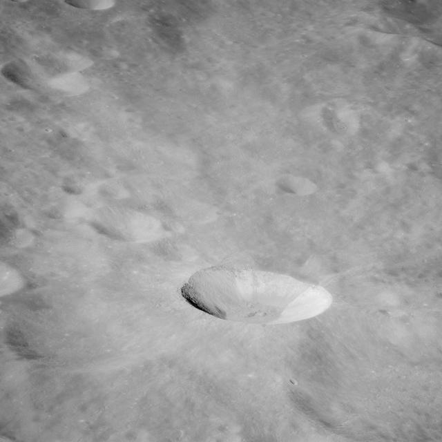
AS11-44-6609 (16-24 July 1969) --- An oblique of the Crater Daedalus on the lunar farside as seen from the Apollo 11 spacecraft in lunar orbit. The view looks southwest. Daedalus (formerly referred to as I.A.U. Crater No. 308) is located at…
Oblique view of lunar farside photographed from orbit looking southwest
AS11-43-6422 (July 1969) --- An Apollo 11 oblique view of the lunar farside.  These two odd-shaped craters are located midway between International Astronomical Union craters 218 and 220, and are centered at 155 degrees east longitude and 3…
Apollo 11 oblique view of lunar farside
AS11-42-6237 (20 July 1969) --- An Apollo 11 oblique view of the large crater Theophilus located at the northwest edge of the Sea of Nectar on the lunar nearside. Theophilus is about 60 statute miles in diameter. The smooth area is Mare Nec…
Oblique view of crater Theophilus at northwest edge of Sea of Nectar
S66-38275 (3-6 June 1966) --- Earth's limb at sunrise as seen from the orbiting Gemini-9 spacecraft during its three-day mission in space. Taken with a modified 70mm Hasselblad camera, using Eastman Kodak, Ektachrome MS (S.O. 217) color fil…
Earth's limb at sunrise as seen from the Gemini 9-A spacecraft
AST-27-2339 (20 July 1975) --- The Earth’s limb at sunrise and cloud silhouettes in the Southern Hemisphere, as photographed from the Apollo spacecraft during the joint U.S.-USSR Apollo-Soyuz Test Project mission. The photograph was taken a…
Earth's limb and cloud silhouette in Southern Hemisphere
AS8-15-2561 (21-27 Dec. 1968) --- View of Earth as photographed by the Apollo 8 astronauts on their return trip from the moon. Note that the terminator is straighter than on the outbound pictures. The terminator crosses Australia. India is…
View of earth during return from moon taken from Apollo 8 spacecraft
S71-58222 (31 July-2 Aug. 1971) --- During the lunar eclipse that occurred during the Apollo 15 lunar landing mission, astronaut Alfred M. Worden, command module pilot, used a 35mm Nikon camera to obtain a series of 15 photographs while the…
Apollo 15 Lunar eclipse views
AS17-152-23279 (7-19 Dec. 1972) --- Eclipsed by the silhouetted horizon of the moon, the crescent Earth appears in the shape of a Viking's headwear in this unusual Apollo 17 photograph. The three astronauts--Eugene A. Cernan, Ronald E. Evan…
Cresent Earth eclipsed by silhouetted horizon of the moon
AS07-07-1832 (15 Oct. 1968) --- Toba, Kakar, Fort Sandeman, Sulaiman Range area in (West) Pakistan, as seen from the Apollo 7 spacecraft during its 84th revolution of Earth. Note geological features such as folded mountain structures, antic…
Mountain ranges in western Pakistan as seen from the Apollo 7 spacecraft
SL3-121-2371 (July-September 1973) --- A pattern of downstream eddies in the stratocumulus clouds over the Pacific Ocean west of Baja California, as photographed by the crewmen of the second Skylab manned mission (Skylab 3) from the space s…
Pattern of downstream eddies in stratocumulus clouds over Pacific Ocean
AS10-34-5026 (18-26 May 1969) --- An Apollo 10 photograph of Earth taken from 100,000 miles away. Visible are many areas of Europe and Africa. Among the features and countries identifiable are Portugal, Spain, Italy, the Mediterranean Sea,…
Apollo 10 view of the Earth
AS12-50-7362 (14 Nov. 1969) --- A view of one-third of Earth, with Australia on the horizon, as photographed by the three-man crew of Apollo 12. The Command and Service Modules, mated to the Lunar Module (yet to be removed and transposition…
View of the Earth seen from the Apollo 12 spacecraft
AS17-148-22727 (7 Dec. 1972) --- This view of Earth was seen by the Apollo 17 crew as they traveled toward the moon on their NASA lunar landing mission. This outstanding trans-lunar coast photograph extends from the Mediterranean Sea area t…
View of the Earth seen by the Apollo 17 crew traveling toward the moon
AS15-91-12343 (26 July 1971) --- This view of Earth was photographed by the Apollo 15 crewmen as they sped toward the fourth lunar landing. The spacecraft was between 25,000 and 30,000 nautical miles from Earth when this photo was made. The…
View of Earth photographed by Apollo 15 on voyage to the Moon
AS10-27-3890 (18-26 May 1969) --- A view of Earth rising above the lunar horizon photographed from the Apollo 10 Lunar Module, looking west in the direction of travel. The Lunar Module at the time the picture was taken was located above the…
Apollo 10 view of the Earth rising above the lunar horizon
AS11-44-6689 (16-24 July 1969) --- One-third of the Earth's sphere illuminated, Earth's terminator, sunglint, a portion of east Africa, as photographed from the Apollo 11 spacecraft during its first lunar landing mission. While astronauts N…
One-third of Earth's sphere as seen from Apollo 11 spacecraft
AS11-43-6439 (July 1969) --- An Apollo 11 oblique view of the lunar farside.  The linear group of small craters is located within the large International Astronomical Union crater No. IX, and is centered at 139.5 degrees east longitude and…
Apollo 11 oblique view of lunar farside
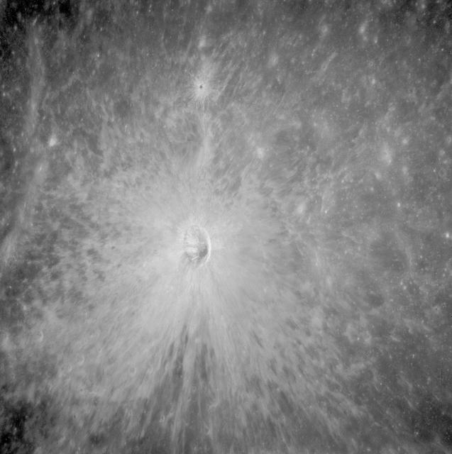
AS11-42-6285 (July 1969) --- An Apollo 11 view of a bright rayed crater on the lunar farside.  The crater is unnamed.  The center of this photograph is located at 100 degrees southeast longitude and 4 degrees 30 minutes north latitude.  Thi…
View of bright-rayed crater on lunar farside
AS11-42-6248 (July 1969) --- An Apollo 11 oblique view of the lunar farside in the area of International Astronomical Union crater No. 312, which is about 30 statute miles in diameter.  The center of the photograph is located at 164 degrees…
Oblique view of lunar farside in area of IAU crater no. 312
AS11-44-6549 (16-24 July 1969) --- This view from the Apollo 11 spacecraft shows Earth rising above the moon's horizon. The lunar terrain pictured is in the area of Smyth's Sea on the nearside. Coordinates of the center of the terrain are 8…
View of Earth rising over Moon's horizon taken from Apollo 11 spacecraft
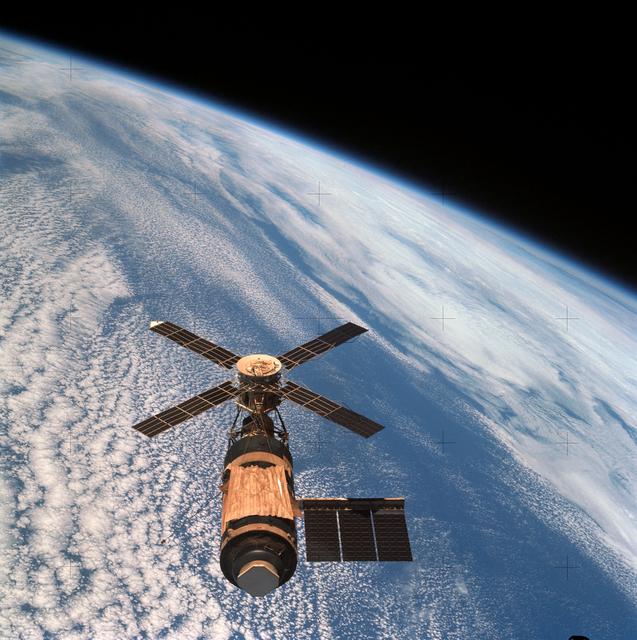
SL4-143-4706 (8 Feb. 1974) --- An overhead view of the Skylab space station cluster in Earth orbit as photographed from the Skylab 4 Command and Service Modules (CSM) during the final fly-around by the CSM before returning home. The space s…
View of Skylab space station cluster in Earth orbit from CSM
SL3-28-059 (July-September 1973) --- A vertical view of the Lake Mead and Las Vegas, Nevada area as photographed from Earth orbit by one of the six lenses of the Itek-furnished S190-A Multispectral Photographic Facility Experiment aboard th…
View of Lake Mead and Las Vegas, Nevada area from Sklyab
AST-02-130 (20 July 1975) --- An oblique view of a portion of Libya and the Arab Republic of Egypt, as photographed from the Apollo spacecraft in Earth orbit during the joint U.S.-USSR Apollo-Soyuz Test Project mission. The geological featu…
View of portion of Libya and Arab Republic of Egypt
SL2-03-118 (June 1973) --- An infrared photograph of the San Francisco Bay, California area, taken from the Skylab 1/2 space station in Earth orbit. THE PICTURE SHOULD BE HELD WITH THE CLOUDS AND PACIFIC OCEAN ON THE LEFT. This photograph w…
San Francisco and Bay Area, CA, USA
AS07-05-1644 (13 Oct. 1968) --- Remarkable cloud patterns as seen from the Apollo 7 spacecraft during its 34th revolution of Earth. Note break in two adjacent decks of strato-cumulus cloud formations. Sea can be seen through holes in clouds…
Cloud patterns as seen from the Apollo 7 spacecraft
S65-63826 (5 Dec. 1965) --- Oriente Province, eastern end of Cuba, as seen from the National Aeronautics and Space Administration's Gemini-7 spacecraft during its 14th revolution of Earth. Guantanamo Bay is in the center of the picture on t…
Orienete Province, eastern end of Cuba as seen from Gemini 7 spacecraft
AS11-36-5337 (16 July 1969) --- This view of Earth showing clouds over its surface was photographed from the Apollo 11 spacecraft during its translunar journey toward the moon. The spacecraft was already about 10,000 nautical miles from Ear…
View of Earth taken by Apollo 11 crewmembers
AS13-60-8588 (17 April 1970) --- This photograph of Earth was taken from the National Aeronautics and Space Administration's (NASA) Apollo 13 spacecraft during its trans-Earth journey home. The most visible land mass includes southwestern U…
Photograph of Earth taken from Apollo 13 spacecraft during transearth journey
AS16-118-18880 (16 April 1972) --- A good view of Earth photographed about one hour after trans-lunar injection on April 16, 1972. Although there is much cloud cover, the United States in large part, most of Mexico and some of Central Ameri…
Apollo 16 view of the earth from translunar injection
AS16-118-18873 (16 April 1972) --- A good view of Earth photographed shortly after trans-lunar injection of April 16, 1972. Although there is much cloud cover (over Canada and the oceans), the United States in large part, most of Mexico and…
Apollo 16 view of the earth from translunar injection
AS10-34-5013 (18 May 1969) --- A view of Earth from 36,000 nautical miles away as photographed from the Apollo 10 spacecraft during its trans-lunar journey toward the moon. While the Yucatan Peninsula is obscured by clouds, nearly all of Me…
Apollo 10 view of the Earth
AS11-36-5355 (17 July 1969) --- Most of Africa and portions of Europe and Asia can be seen in this spectacular photograph taken from the Apollo 11 spacecraft during its trans-lunar coast toward the moon. Apollo 11, with astronauts Neil A. A…
View of Earth, showing Africa, Europe and Asia taken by Apollo 11 crewmember
AS11-43-6412 (July 1969) --- This is a northeasterly, low-oblique view of an unmanned crater and highland area on the lunar farside, as photographed from Apollo 11. The center of the picture is located at the 167 degrees east longitude and…
Northeasterly, low-oblique view of unnamed crater on lunar farside
SL3-28-009 (July-September 1973) --- A near vertical view of the Minneapolis-St. Paul, Minnesota area, as photographed from Earth orbit by one of the six lenses of the Itek-furnished S190-A Multispectral Photographic Facility Experiment in…
View of Minneapolis-St.Paul, Minnesota area
SL4-93-167 (February 1974) --- A vertical view of the Kennedy Space Center and the Florida Atlantic coast area is seen in this Skylab 4 Earth Resources Experiments Package S190-B (five-inch earth terrain camera) infrared photography taken f…
Kennedy Space Center and the Florida Atlantic coast area
SL4-143-4707 (8 Feb. 1974) --- An overhead view of the Skylab space station cluster in Earth orbit as photographed from the Skylab 4 Command and Service Modules (CSM) during the final fly-around by the CSM before returning home. The space s…
View of Skylab space station cluster in Earth orbit from CSM
AS11-44-6552 (16-24 July 1969) --- This view of Earth rising over the moon's horizon was taken from the Apollo spacecraft. The lunar terrain pictured is in the area of Smyth's Sea on the nearside. Coordinates of the center of the terrain ar…
View of Earth rising over Moon's horizon taken from Apollo 11 spacecraft
iss074e0208838 (Jan. 26, 2026) --- The Colorado River began carving the Grand Canyon—one of the Seven Natural Wonders of the World and a UNESCO World Heritage Site in Arizona—about 5 to 6 million years ago. This photograph was taken from th…
The Grand Canyon in Arizona pictured from the International Space Station
AS08-14-2383 (24 Dec. 1968) --- The rising Earth is about five degrees above the lunar horizon in this telephoto view taken from the Apollo 8 spacecraft near 110 degrees east longitude. The horizon, about 570 kilometers (350 statute miles)…
Apollo 8 Mission image, Earth over the horizon of the moon
SL4-140-4110 (January 1974) --- View of the USSR, Siberia area from Skylab 4. Other areas seen are Ozero, Kanka, Ussiriysk, the Sea of Japan and Kavalerovo (45.5N, 135.5E). Photo credit: NASA
View of USSR, Siberia, Ozero, Kanka, Ussiriysk, Sea of Japan and Kavalerovo
AS12-47-6891 (14-24 Nov. 1969) --- A partially illuminated Earth rises above the lunar horizon in this photograph taken from the Apollo 12 spacecraft in lunar orbit.
Earth rises above the lunar horizon as seen from Apollo 12 in lunar orbit
AST-30-2601 (20 July 1975) --- An area of the Cascade Mountains southeast of Seattle in the State of Washington, as photographed from the Apollo spacecraft in Earth orbit during the joint U.S.-USSR Apollo-Soyuz Test Project mission. The vie…
Area of Cascade Mountains southeast of Seattle in State of Washington