Atmospheric methane is a potent greenhouse gas, but the percentage of it produced through human activities is still poorly understood. Future instruments on orbiting satellites can help address this issue by surveying human-produced methane…
A First: NASA Spots Single Methane Leak from Space
S62-06612 (3 Oct. 1962) --- Cloud formation over South America taken during the fifth orbit pass of the Mercury-Atlas 8 (MA-8) mission by astronaut Walter M. Schirra Jr. with a hand-held camera. Photo credit: NASA
Cloud formation over South America - fifth orbit pass
STS098-713a-019 (16 February 2001) --- The International Space Station is backdropped over clouds, water and land in South America. South central Chile shows up at bottom of the frame. Just below the Destiny laboratory, the Chacao Channel s…
sts098-713a-019
S62-06604 (3 Oct. 1962) --- Western horizon over South America taken during the sixth orbit pass of the Mercury-Atlas 8 (MA-8) mission by astronaut Walter M. Schirra Jr. with a hand-held camera. Photo credit: NASA
Horizon photo of Western horizon over South America - sixth orbit pass
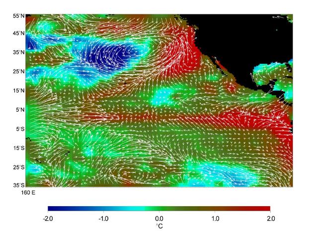
This image displays wind measurements taken by the satellite-borne NASA Scatterometer NSCAT during the last 10 days of May 1997, showing the relationship between the ocean and the atmosphere at the onset of the 1997-98 El Niño condition.
Microwave Limb Sounder/El Niño Watch - 1997 Research Data Reveal Clues about El Niño Influence
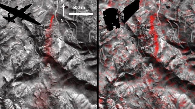
NASA's Airborne Visible Infrared Imaging Spectrometer instrument (AVIRIS), flying aboard a NASA Armstrong Flight Research Center high-altitude ER-2 aircraft, observed wildfires burning in Southern California on Dec. 5-7, 2017. AVIRIS is an…
Multiple Aspects of the Southern California Wildfires as Seen by NASA's AVIRIS
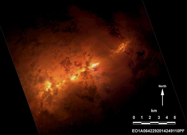
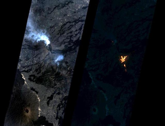
Momotombo volcano, Nicaragua, began erupting on Dec. 1, 2015, after more than a century of inactivity. On Dec. 4, 2015, the Advanced Land Imager (ALI) on NASA's Earth Observing 1 (EO-1) spacecraft observed the new eruption. This image is cr…
Nicaragua Eruption Lava Threat Closely Monitored by NASA EO-1 Spacecraft
On the night of Sept. 6, 2014 NASA Earth Observing 1 EO-1 spacecraft observed the ongoing eruption at Holuhraun, Iceland. Partially covered by clouds, this scene shows the extent of the lava flows that have been erupting.
Progress of Icelandic Lava Flows Charted by NASA EO-1 Spacecraft
STS098-712-091 (7-20 February 2001) ---   The forested area of the Panama Canal Zone can be seen near the center of this north-looking image, photographed with a 70mm handheld camera from the Earth-orbiting Space Shuttle Atlantis.  (NOTE: T…
Earth observations taken during STS-98 mission
ISS008-E-14686 (7 February 2004) --- This image featuring southern Spain was photographed by an Expedition 8 crewmember on the International Space Station (ISS). Over the past 50 years, the small coastal plain (campo), some 30 kilometers so…
iss008e14686
STS098-714A-020 (7-20 February 2001) ---One of the STS-98 astronauts aboard the Earth-orbiting Space Shuttle Atlantis used a 70mm handheld camera to record this image of Southern California.  Snow blanketing the higher elevations in the Los…
Earth observations taken during STS-98 mission
STS098-382-0014 (7-20 February 2001)  City Lights of the Northeastern Seaboard of the U.S. were captured with a 35mm camera by one of the STS-98 astronauts aboard the Space Shuttle Atlantis.  The nighttime scene  shows the bright lights of…
Earth observation taken during STS-98 mission
STS098-714A-049 (16 February 2001) --- Demonstrating the power of water erosion, this orbital view photographed by the crew of Atlantis during STS-98 on February 16, 2001, as the spacecraft orbited the earth at an altitude of 173 nautical m…
Earth observations taken during STS-98 mission
Oblique Earth Observation taken by the Apollo 9 crew. View is of California and includes Sierra Nevada, and the Mojave Desert. Film magazine was E,film type was SO-368 Ektachrome with 0.460 - 0.710 micrometers film / filter transmittance re…
Apollo 9 Mission image - California
STS004-41-1206 (27 June-4July 1982) --- Sunglint reflects off the water of the North Atlantic Ocean in an area to the east of the Bahamas Islands sometimes called the Sargasso Sea. The area has also been referred to as the ?Bermuda Triangle…
Clouds and Open Ocean near the Bahamas
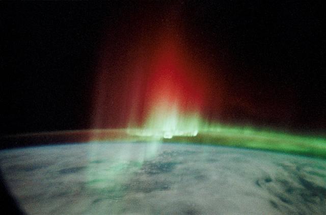
STS039-23-036 (28 April-6 May 1991) --- A 35mm frame of the Aurora Australis, also known as the Southern Lights, photographed from the Space Shuttle Discovery's flight deck by one of its seven crew members. One of the mission objectives was…
Aurora Australis, Red Crown
STS039-377-013 (28 April-6 May 1991) --- Moonlight saturates the high speed film used for auroral photography.  Moon glint is visible in the open ocean and the cloud patterns are well illuminated.  This frame was taken with a handheld 35mm…
Aurora Australis, Spiked and Sinuous Red and Green Airglow
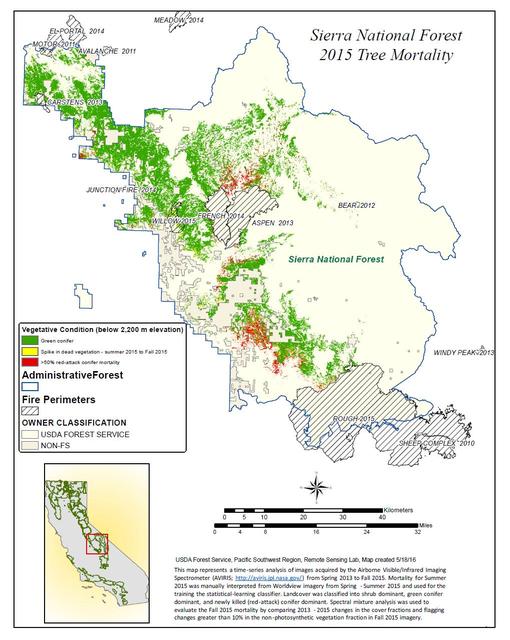
California, reveals the devastating effect of California's ongoing drought on Sierra Nevada conifer forests.  The map will be used to help the U.S. Forest Service assess and respond to the impacts of increased tree mortality caused by the d…
California Drought Effects on Sierra Trees Mapped by NASA
Earth Observation taken by the Expedition 43 crew.    Earth observation taken during a day pass by the Expedition 43 crew aboard the International Space Station (ISS). Folder lists this as North Africa.
Earth Observation taken by the Expedition 43 crew
S62-06606 (3 Oct. 1962) --- Cloud formation over Western Atlantic Ocean north of South America taken during the fourth orbit pass of the Mercury-Atlas 8 (MA-8) mission by astronaut Walter M. Schirra Jr. with a hand-held camera. Photo credit…
Cloud formation over Western Atlantic Ocean north of South America
This image shows Iceland volcanic eruption monitored by NASA EO-1 spacecraft. To the south is the edge of Dyngjujökull and to the north is the volcano called Askja.
Iceland Volcanic Eruption Monitored by NASA EO-1 Spacecraft
NASA's Airborne Visible Infrared Imaging Spectrometer instrument (AVIRIS), flying aboard a NASA Armstrong Flight Research Center high-altitude ER-2 aircraft, flew over the wildfires burning in Southern California on Dec. 5, 2017 and acquire…
NASA's AVIRIS Instrument Sheds New Light on Southern California Wildfires
On Jan. 24, 2017, the Hyperion Imager on NASA's Earth Observing 1 (EO-1) spacecraft observed a new eruption at Erta'Ale volcano, Ethiopia, from an altitude of 438 miles (705 kilometers). Data were collected at a resolution of 98 feet (30 me…
NASA Spacecraft Watches as Eruption Reshapes African Volcano
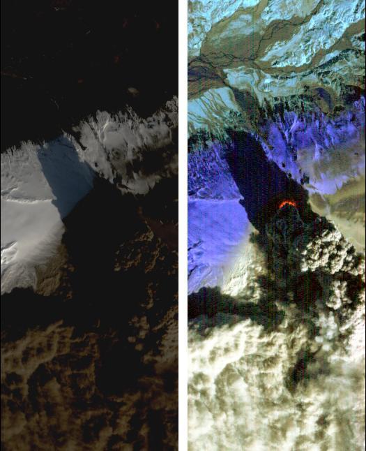
On Saturday, April 17, 2010, NASA Earth Observing-1 EO-1 spacecraft obtained this pair of images of the continuing eruption of Iceland Eyjafjallajökull volcano. On the left, new black ash deposits are visible on the ground.
NASA Satellite Eyes Iceland Volcano Cauldron
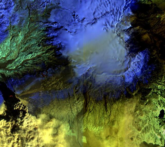
The Advanced Land Imager onboard NASA Earth Observing-1 EO-1 spacecraft obtained this false-color infrared image of Iceland Eyjafjallajökull volcano on April 17, 2010. A strong thermal source is visible at the base of the Eyjafjallajökull p…
NASA Satellite Observes Iceland Eyjafjallajökull Volcano in Infrared
STS098-819-038 (17 February 2001) --- Much of Metropolitan Houston appears in this nearly vertical image photographed with a handheld 70mm camera onboard the Earth-orbiting Space Shuttle Atlantis.  Interstate 45 and Highways 146 and 6 can b…
Earth observations taken during STS-98 mission
Overexposed earth observations taken during the NASA/Mir 21 mission from the Russian space station Mir by astronaut Shannon Lucid.
Earth observations taken during the NASA/Mir 21 mission
STS098-716-034 (18 February 2001) --- This east-to-west orbital view of the Inn River Valley of southern Austria was photographed by one the crew members of Atlantis during Space Shuttle Mission STS-98 on February 18, 2001, as the spacecraf…
Earth observation taken during STS-98 mission
Vertical Earth Observation taken by the Apollo 9 crew. View is of Peru and South America including Aguja Point and Piura. Film magazine was E,film type was SO-368 Ektachrome with 0.460 - 0.710 micrometers film / filter transmittance respons…
Apollo 9 Mission image - Peru and South America
Eight days after its encounter with the Earth, the Galileo spacecraft was able to look back and capture this remarkable view of the Moon in orbit about the Earth, taken from a distance of about 6.2 million kilometers (3.9 million miles). Th…
Galileo view of Moon orbiting the Earth taken from 3.9 million miles
STS039-23-020 (28 April-6 May 1991) --- A 35mm frame of the Aurora Australis, also known as the Southern Lights, photographed from Space Shuttle Discovery's flight deck by one of its seven crew members.  One of the mission objectives was to…
Aurora Australis, Sinuous Loop
STS039-25-006 (28 April-6 May 1991) --- A 35mm frame of the Aurora Australis, also known as the Southern Lights, photographed from the Space Shuttle Discovery's flight deck by one of its seven crew members. One of the mission objectives was…
Aurora Australis, Spiked, Sinuous Green Airglow
   Apollo 7,Cumulus,alto-cumulus,cirrus clouds. Very high oblique. Cloud Cover 50%. Original film magazine was labeled S. Camera Data: Hasselblad 500-C; Lens: Zeiss Planar,F/2.8,80mm; Film Type: Kodak SO-121,Aerial Ektachrome; Filter: Wratt…
Apollo 7 Mission,Clouds
S62-06607 (3 Oct. 1962) --- Western horizon over South America taken during the sixth orbit pass of the Mercury-Atlas 8 (MA-8) mission by astronaut Walter M. Schirra Jr. with a hand-held camera. Photo credit: NASA
Horizon photo of Western horizon over South America - sixth orbit pass
S62-06613 (3 Oct. 1962) --- Cumulus cloud formation over West Atlantic Ocean north of South American during the fourth orbit pass of the Mercury-Atlas 8 (MA-8) mission by astronaut Walter M. Schirra Jr. with a hand-held camera. Photo credit…
Cumulus cloud formation over West Atlantic Ocean north of South America
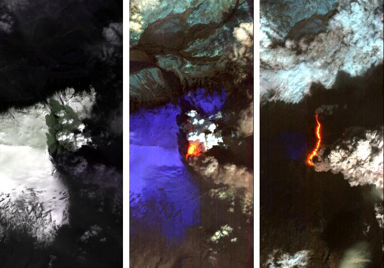
Dramatic changes have been observed at the Eyjafjallajökull volcano in Iceland by NASA's Earth Observing 1 (EO-1) spacecraft. On May 2, 2010, the Hyperion hyperspectral imager on EO-1 imaged Eyjafjallajökull and identified the extent of a l…
Iceland Volcano Puffs Ash as Lava Flow Cuts Through Eyjafjallajökull Icecap
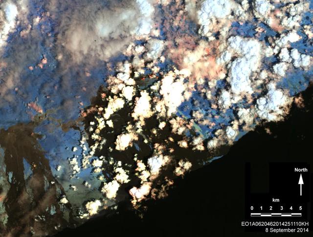
On Sept. 8, 2014, NASA Earth Observing 1 spacecraft obtained this infrared image of Kilauea volcano, Hawaii, which has been in continuous eruption since 1983. New lava flows can be seen.
Hawaii Lava Threat Closely Monitored by NASA EO-1 Spacecraft
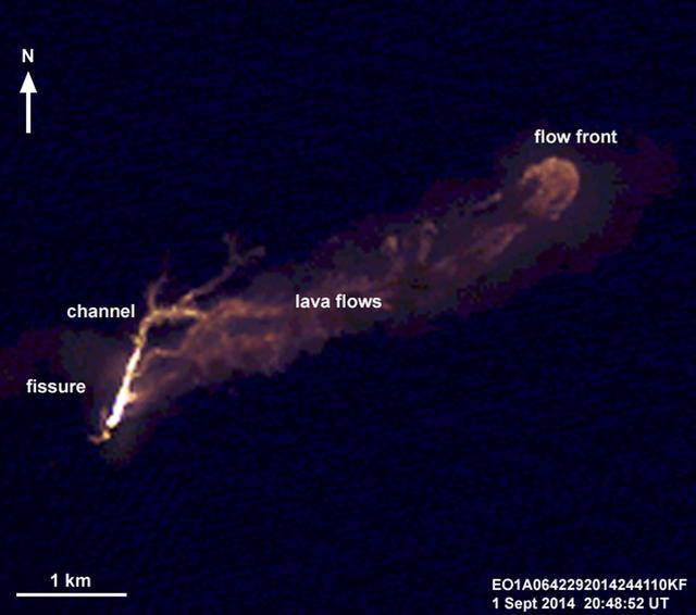
On the night of Sept. 1, 2014, NASA Earth Observing 1 EO-1 spacecraft observed the ongoing eruption at Holuhraun, Iceland. This false-color image that emphasizes the hottest areas of the vent and resulting lava flows.
NASA Spacecraft Eyes Iceland Volcanic Eruption
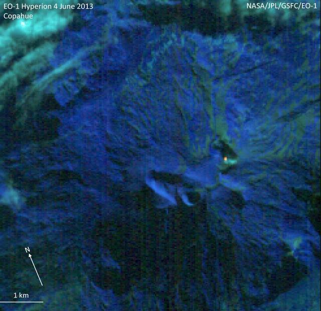
NASA Earth Observing-1 EO-1 spacecraft observed Copahue volcano, a 2965 meter high volcano on the Chile-Argentina border, on Jun. 4, 2013. Having recently displayed signs of unrest, the volcano is under close scrutiny by local volcanologist…
NASA Earth Observing-1 Keeps Watchful Eye on South American Volcano Copahue
On June 14, 2011, NASA Earth Observing-1 EO-1 spacecraft obtained this image showing ash-rich volcanic plume billowing out of the vent, punching through a low cloud layer. The plume grey color is a reflection of its ash content.
NASA EO-1 Spacecraft Images Chile Volcanic Eruption
   Vertical Earth Observation taken by the Apollo 9 crew. View is of North Carolina including Cape Lookout and Pamilco Sound. Film magazine was E,film type was SO-368 Ektachrome with 0.460 - 0.710 micrometers film / filter transmittance res…
Apollo 9 Mission image - North Carolina
Oblique Earth Observation taken by the Apollo 9 crew. View is the United Arab Republic,the Nile River,The Red Sea and the Aswan Dam. Film magazine was E,film type was SO-368 Ektachrome with 0.460 - 0.710 micrometers film / filter transmitta…
Apollo 9 Mission image - United Arab Republic,Nile River,Red Sea and Aswan Dam
STS098-716-057 (7-20 February 2001) ---   Baltimore, Maryland can be identified in this northwest-looking view, photographed with a 70mm handheld camera  from the Space Shuttle Atlantis, which shows the western shore of Chesapeake Bay.  Num…
Earth observation taken during STS-98 mission
STS098-713-011 (15 February 2001) --- An oblique, westerly-looking view over the Strait of Messini (center), which runs between Italy's "foot" part of the so-called "boot" (bottom) and the heavily cloud-covered Sicily (t…
Earth observations taken during STS-98 flight
Oblique Earth Observation taken by the Apollo 9 crew. View is of southwest Africa near Cape Fria. Film magazine was E,film type was SO-368 Ektachrome with 0.460 - 0.710 micrometers film / filter transmittance response and haze filter,80mm l…
Apollo 9 Mission image - Southwest Africa
Oblique Earth Observation taken by the Apollo 9 crew. View is of California including: Sanata Barbara, Los Angeles, San Diego, Santa Rosa, San Miguel, and Santa Cruz Islands, Santa Barbara Channel, Salton Sea and the Service Module (SM) Lun…
Apollo 9 Mission image - Earth limb over California with S.L.A. in distance
This concept illustrates Skylab Earth observation studies, an Earth Resources Experiment Package (EREP). EREP was designed to explore the use of the widest possible portion of the electromagnetic spectrum for Earth resource investigations w…
Skylab
STS039-342-026 (28 April-6 May 1991) --- This view of the Aurora Australis, or Southern Lights, shows a band of airglow above the limb of Earth.  Photo experts at NASA studying the mission photography identify the airglow as being in the 80…
Aurora Australis, Spiked and Sinuous Red and Green Airglow