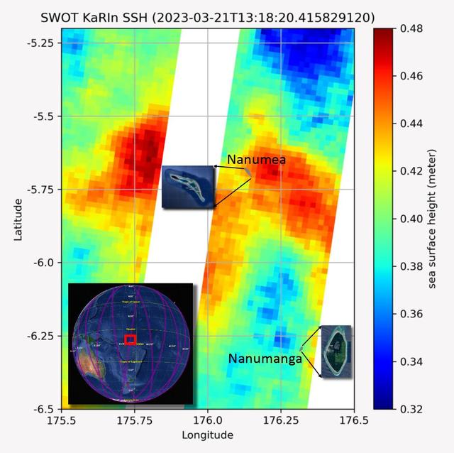
The recently launched Surface Water and Ocean Topography (SWOT) mission collected data on sea levels around two of the inhabited islands of Tuvalu, a nation in the South Pacific Ocean that has been threatened with sea level rise that substa…
SWOT Measures Tuvalu Sea Level
This animation, created in 2012, shows the increasing clarity and detail of measurements of sea height made by successive satellite altimeters launched by NASA and other agencies over the past four decades, concluding with data at the resol…
SWOT Satellite will Improve Clarity and Detail of Sea Height Measurements
Scientists on NASA's EMIT mission used data from its powerful imaging spectrometer, developed at the agency's Jet Propulsion Laboratory, to map the presence and geographic distributions of three key minerals in the planet's arid regions. Th…
NASA's EMIT Mission Produces Maps of Arid Region Surface Minerals
This image shows the first measurements taken by NASA's Earth Surface Mineral Dust Source Investigation (EMIT) from aboard the International Space Station at 7:51 p.m. PDT (10:51 p.m. EDT) on July 27, 2022, as it passed over western Austral…
EMIT Instrument's First Light
The front panel of this image cube features the true-color view of an area in southwest Libya observed by NASA's Earth Surface Mineral Dust Source Investigation (EMIT) imaging spectrometer, which orbits the planet aboard the International S…
NASA's EMIT Mission Generates Image Cube of Surface Minerals in Southwestern Libya
NASA's Earth Surface Mineral Dust Source Investigation (EMIT) detected a cluster of 12 methane plumes on Sept. 1, 2022, in an approximately 150-square-mile (400-square-kilometer) region of southern Uzbekistan. Methane is a potent greenhouse…
EMIT Identifying Methane Plumes Around the Globe
The European Retrievable Carrier 1L (EURECA-1L) spacecraft, with solar array panels extended, drifts above the Earth after deployment from the payload bay of Atlantis, Orbiter Vehicle (OV) 104, during STS-46. EURECA's onboard propulsion uni…
EURECA-1L drifts above the Earth surface after STS-46 deployment from OV-104
STS053-105-002 (2-9 Dec. 1992) --- A crew member onboard the space shuttle Discovery used a 70mm camera to capture this scene of a full Moon backdropped against the blackness of space. Part of Discovery's aft cargo bay and clouds over an oc…
STS-53 view of OV-103's payload bay (PLB), the Moon, and Earth's surface
AS10-27-3890 (18-26 May 1969) --- A view of Earth rising above the lunar horizon photographed from the Apollo 10 Lunar Module, looking west in the direction of travel. The Lunar Module at the time the picture was taken was located above the…
Apollo 10 view of the Earth rising above the lunar horizon
AS17-134-20473 (13 Dec. 1972) --- Earth appears in the far distant background above the hi-gain antenna of the Lunar Roving Vehicle in this photograph taken by scientist-astronaut Harrison H. Schmitt during the third Apollo 17 extravehicula…
View of Earth above the antenna of the lunar roving vehicle during EVA
STS054-71-077 (13 Jan 1993) --- The Tracking and Data Relay Satellite (TDRS) quickly moves away from the Space Shuttle Endeavour following deployment on the first day of the six-day mission.  Onboard NASA's newest Shuttle for the six-day mi…
IUS / TDRS-F drifts above the Earth's surface after STS-54 deployment
AS08-14-2383 (24 Dec. 1968) --- The rising Earth is about five degrees above the lunar horizon in this telephoto view taken from the Apollo 8 spacecraft near 110 degrees east longitude. The horizon, about 570 kilometers (350 statute miles)…
Apollo 8 Mission image, Earth over the horizon of the moon
STS043-601-033 (2 Aug 1991) --- The Tracking and Data Relay Satellite (TDRS-E), is seen almost as a silhouette in this 70mm image.  The TDRS spacecraft was captured on film as it moved away from the earth-orbiting Atlantis a mere six hours…
STS-43 TDRS-E & IUS over the Pacific Ocean after deployment from OV-104's PLB
AS8-14-2392 (21-27 Dec. 1968) --- High-oblique view of the moon's surface showing Earth rising above the lunar horizon, looking west-southwest, as photographed from the Apollo 8 spacecraft as it orbited the moon. The center of the picture i…
High-oblique view of Moon's surface showing earth rising above horizon
AS11-44-6634 (21 July 1969) --- The Apollo 11 Lunar Module (LM) ascent stage, with astronauts Neil A. Armstrong and Edwin E. Aldrin Jr. onboard, is photographed from the Command and Services Modules (CSM) in lunar orbit. This view is lookin…
Apollo 11 Lunar Module ascent stage photographed from Command Module
STS031-03-014 (25 April 1990) --- The Hubble Space Telescope (HST), still in the grasp of Discovery's Remote Manipulator System (RMS), is backdropped over Earth some 332 nautical miles below. In this scene, HST has deployed one of its solar…
STS-31 Hubble Space Telescope (HST) appendage deploy aboard OV-103
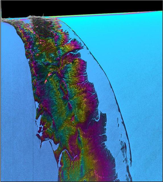
This visualization shows sea surface height measurements in the Gulf Stream off the coast of North Carolina and Virginia. The data was collected on Jan. 21, 2023, by an instrument on the Surface Water and Ocean Topography (SWOT) satellite c…
SWOT Satellite's Sea Level 'First Light'
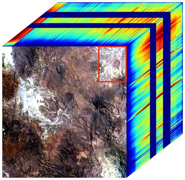
The front panel of this image cube shows the true-color view of an area in northwest Nevada observed by NASA's Earth Surface Mineral Dust Source Investigation (EMIT) imaging spectrometer. The side panels depict the spectral fingerprint for…
NASA's EMIT Generates Image Cube of Surface Minerals in Northwest Nevada
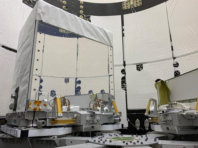
The Earth Surface Mineral Dust Source Investigation (EMIT) mission instrument (right) sits in the "trunk" that will travel aboard SpaceX's 25th cargo resupply mission – planned for June 7, 2022 – to the International Space Station. This ima…
EMIT Loaded Into SpaceX Falcon 9 Trunk Before Transport
A plume of methane – a potent greenhouse gas about 80 times more effective at trapping heat in the atmosphere than carbon dioxide – is detected flowing from an area southeast of Carlsbad, New Mexico, in an image that uses data from NASA's E…
EMIT Spots Methane Hotspots
This image shows locations in parts of North Africa, Europe, the Middle East, and Central Asia observed by NASA's Earth Surface Mineral Dust Source Investigation (EMIT). Each blue box is a "scene" the instrument, which is aboard the Interna…
NASA's EMIT Measures Surface Dust in North Africa, Europe, the Middle East, Central Asia
Produced with data from NASA's Earth Surface Mineral Dust Source Investigation (EMIT) mission, this image uses two different ways of displaying methane's unique pattern of absorbed infrared light – called a spectral fingerprint. This potent…
EMIT Methane Spectral Fingerprint
Images from the U.S./European Jason-3 satellite show sea surface height with respect to the seasonal cycle and the long-term trend. Blue/magenta colors indicate lower-than-normal sea levels, while yellow/red colors indicate higher-than-norm…
Downwelling Kelvin Wave in the Pacific
STS029-72-059 (13 March 1989) --- This 70mm photograph,  taken by Astronaut James P. Bagian 16 minutes and 7 seconds after liftoff of Discovery, shows the external fuel tank (ET) against the background of Earth.  The tank is falling away fr…
STS-29 Discovery, OV-103, external tank (ET) separation
STS030-71-052 (4 May 1989) --- In the early evening hours of the Space Shuttle Atlantis' first day in space for the four-day mission, the Magellan spacecraft begins its long journey to the planet Venus for an extensive radar mapping mission…
STS-30 deployment of inertial upper stage (IUS) with Magellan spacecraft
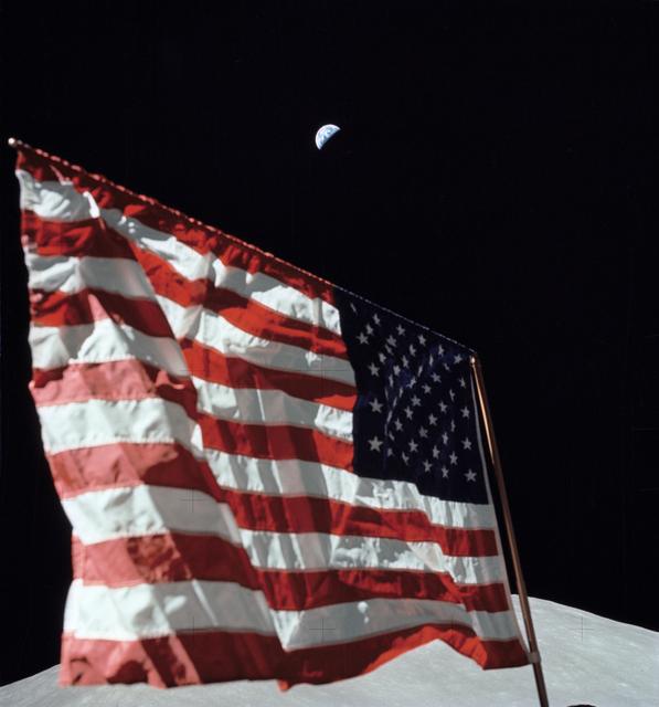
AS17-134-20466 (7-19 Dec. 1972) --- A close-up view of the U.S. flag deployed on the moon at the Taurus-Littrow landing site by the crewmen of the Apollo 17 lunar landing mission. The crescent Earth can be seen in the far distant background…
Close-up view of U.S. flag deployed on Moon by Apollo 17 crew
STS054-71-087 (13 Jan 1993) --- The Tracking and Data Relay Satellite (TDRS) is backdropped against the blackness of space, minutes after its release from the Space Shuttle Endeavour.  Onboard NASA's newest Shuttle for the six-day mission a…
IUS / TDRS-F drifts above the Earth's surface after STS-54 deployment
AS11-44-6552 (16-24 July 1969) --- This view of Earth rising over the moon's horizon was taken from the Apollo spacecraft. The lunar terrain pictured is in the area of Smyth's Sea on the nearside. Coordinates of the center of the terrain ar…
View of Earth rising over Moon's horizon taken from Apollo 11 spacecraft
STS026-31-071 (3 Oct 1988) --- After deployment from Discovery, Orbiter Vehicle (OV) 103, the inertial upper stage (IUS) with the tracking and data relay satellite C (TDRS-C) drifts above the cloud-covered Earth surface. TDRS-C, in stowed c…
STS-26 Discovery, Orbiter Vehicle (OV) 103, IUS / TDRS-C deployment
Artist concept shows the Hubble Space Telescope (HST) placed in orbit above the Earth's distorting layer of atmosphere by Discovery, Orbiter Vehicle (OV) 103, during mission STS-31. Tracking and data relay satellite (TDRS) is visible in the…
Artist concept of the Hubble Space Telescope (HST) after STS-31 deployment
These open ocean Internal Waves were seen off the Namibia Coast, Africa (19.5S, 11.5E). The periodic and regularly spaced sets of incoming internal appear to be diffracting against the coastline and recombining to form a network of interfer…
Open ocean Internal Waves, Namibia Coast, Africa.
STS029-71-026 (13 March 1989) --- The Tracking and Data Relay Satellite (TDRS-D) is tilted in the cargo bay prior to its release via a remote system on Discovery's flight deck.  This photographic frame was among NASA's third STS-29 photo re…
STS-29 IUS / TDRS-D deployment from Discovery, OV-103, payload bay
AS11-44-6642 (21 July 1969) --- The Apollo 11 Lunar Module ascent stage, with astronauts Neil A. Armstrong and Edwin E. Aldrin Jr. aboard, is photographed from the Command and Service Modules (CSM) during rendezvous in lunar orbit. The Luna…
Apollo 11 Lunar Module ascent stage photographed from Command Module
The mighty Yukon River and nearby lakes appear in red in this image produced using data recorded on June 18, 2023, by the international Surface Water and Ocean Topography (SWOT) satellite as it passed over Alaska. The satellite measures the…
SWOT Captures the Yukon River in Alaska
This visualization shows water features on New York's Long Island – shown as bright pink splotches nestled within the landscape. Purple, yellow, green, and dark blue shades represent different land elevations, while the surrounding ocean is…
SWOT Satellite's Land 'First Light'
Since NASA's Earth Surface Mineral Dust Source Investigation (EMIT) imaging spectrometer was installed on the International Space Station in late July 2022, the EMIT science team has been validating its data against data gathered in 2018 by…
NASA's EMIT Collects Mineral Maps, Spectral Fingerprints From Nevada
The Earth Surface Mineral Dust Source Investigation (EMIT) mission instrument (left) sits in the "trunk" that will travel aboard SpaceX's 25th cargo resupply mission – planned for June 7, 2022 – to the International Space Station. This imag…
EMIT Inside SpaceX Falcon 9 Trunk Ahead of Transport
The mineral map shows an area of southwestern Libya in the Sahara Desert observed by NASA's Earth Surface Mineral Dust Source Investigation (EMIT) mission as it maps the world's mineral dust sources, gathering information about surface comp…
EMIT Instrument's First Light
This artist concept shows the Hubble Space Telescope (HST) in operational configuration orbiting the Earth after its deploy from Discovery, Orbiter Vehicle (OV) 103 during STS-31. The high gain antennas (HGAs) and solar arrays (SAs) have be…
Artist concept of Hubble Space Telescope (HST) orbiting Earth after deploy
STS031-71-095 (25 April 1990) --- The Hubble Space Telescope (HST) is suspended above Discovery's cargo bay some 332 nautical miles above Earth.  The Canadian-built Remote Manipulator System (RMS) arm, controlled from in-cabin by the astron…
STS-31 pre-deploy check of the Hubble Space Telescope (HST) in OV-103's PLB
STS030-71-053 (4 May 1989) --- In the early evening hours of Space Shuttle Atlantis’ first day in space for the four-day STS-30 mission, the Magellan spacecraft is released into space to begin its long journey to the planet Venus for…
STS-30 inertial upper stage (IUS) with Magellan deployment
AS11-44-6549 (16-24 July 1969) --- This view from the Apollo 11 spacecraft shows Earth rising above the moon's horizon. The lunar terrain pictured is in the area of Smyth's Sea on the nearside. Coordinates of the center of the terrain are 8…
View of Earth rising over Moon's horizon taken from Apollo 11 spacecraft
S89-48714 (18 Oct 1989) --- This photograph was taken by the STS-34 crew aboard the Space Shuttle Atlantis and shows the Galileo spacecraft being deployed on Oct.  18, 1989 from the payload bay. Galileo is a scientific craft that will go in…
STS-34 Galileo spacecraft / IUS deployment taken by the IMAX camera
AS12-47-6891 (14-24 Nov. 1969) --- A partially illuminated Earth rises above the lunar horizon in this photograph taken from the Apollo 12 spacecraft in lunar orbit.
Earth rises above the lunar horizon as seen from Apollo 12 in lunar orbit
These open ocean Internal Waves were seen off the Namibia Coast, Africa (23.0S, 14.0E). The periodic and regularly spaced sets of internal waves most likely coincide with tidal periods about 12 hours apart. The wave length (distance from cr…
Open ocean Internal Waves, Namibia Coast, Africa.
AS16-120-19187 (19 April 1972) --- Apollo 16 astronauts captured this Earth rise scene with a handheld Hasselblad camera during the second revolution of the moon. Identifiable craters seen on the moon include Saha, Wyld, and Saenger. Much o…
Earth rise as photographed by Apollo 16
Held in appendage deploy position by Discovery's, Orbiter Vehicle (OV) 103's, remote manipulator system (RMS), the Hubble Space Telescope's (HST's) starboard solar array (SA) bistem cassette is released from its stowed position on the Suppo…
STS-31 Hubble Space Telescope (HST) solar array panel deploy aboard OV-103
STS049-91-029 (13 May 1992) --- Following the successful capture of Intelsat VI satellite, three astronauts continue their chores toward moving the 4.5 ton communications satellite into the space shuttle Endeavour's cargo bay. A fellow crew…
STS-49 crew captures INTELSAT VI above OV-105's payload bay (PLB) during EVA