S65-18741 (23 March 1965) --- Astronaut John W. Young took this picture during the Gemini-Titan 3 three-orbit mission as the spacecraft "Molly Brown" passed over Northern Mexico. The large light-brown area is the Sonoran Desert. The Colorad…
GEMINI-TITAN (GT)-3 - EARTH-SKY VIEWS - CA
Three days after the Mars Reconnaissance Orbiter Aug. 12, 2005, launch, the spacecraft was pointed toward Earth and the Mars Color Imager camera was powered up to acquire a suite of images of Earth and the Moon.
Calibration View of Earth and the Moon by Mars Color Imager
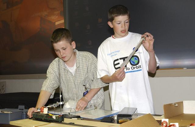
In this photograph, students from all over the country gathered and discussed their Earth-to-Orbit (ETO) Design Challenge project at NASA Marshall Space Flight Center in Huntsville, Alabama. These students who are just "typical teens," have…
Around Marshall
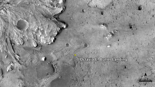
NASA has named the landing site of the agency's Perseverance rover "Octavia E. Butler Landing," after the science fiction author Octavia E. Butler. The landing location is marked with a star in this image from the High Resolution Imaging Ex…
Welcome to "Octavia E. Butler Landing"
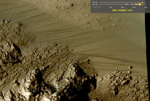
 This image comes from observations of Horowitz crater by the HiRISE camera onboard NASA Mars Reconnaissance Orbiter. The features that extend down the slope during warm seasons are called recurring slope lineae.
Warm-Season Flows on Slope in Horowitz Crater Eight-Image Sequence
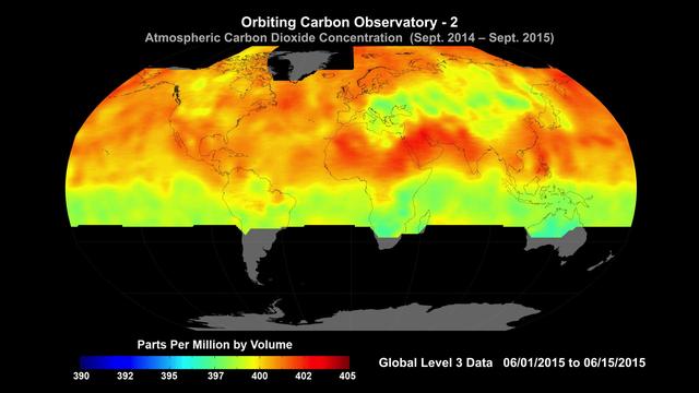
Global average carbon dioxide concentrations as seen by NASA’s Orbiting Carbon Observatory-2 mission, June 1-15, 2015. OCO-2 measures carbon dioxide from the top of Earth's atmosphere to its surface. Higher carbon dioxide concentrations are…
NASA Carbon Sleuth Begins Year Two
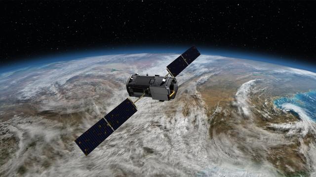
Artist rendering of NASA Orbiting Carbon Observatory OCO-2, one of five new NASA Earth science missions set to launch in 2014, and one of three managed by JPL.
NASA Orbiting Carbon Observatory OCO-2 Artist Concept
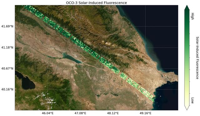
Image shows OCO-3's first preliminary solar-induced fluorescence (SIF) measurements over western Asia. Solar-induced fluorescence is the glow plants emit from photosynthesis — the process of plant growth that includes the capture of carbon…
OCO-3's First Solar-Induced Fluorescence Measurements
NASA Orbiting Carbon Observatory-2, perched atop a United Launch Alliance Delta II rocket, awaits launch at the Vandenberg Air Force Base in central California.
Orbiting Carbon Observatory-2 on the Pad
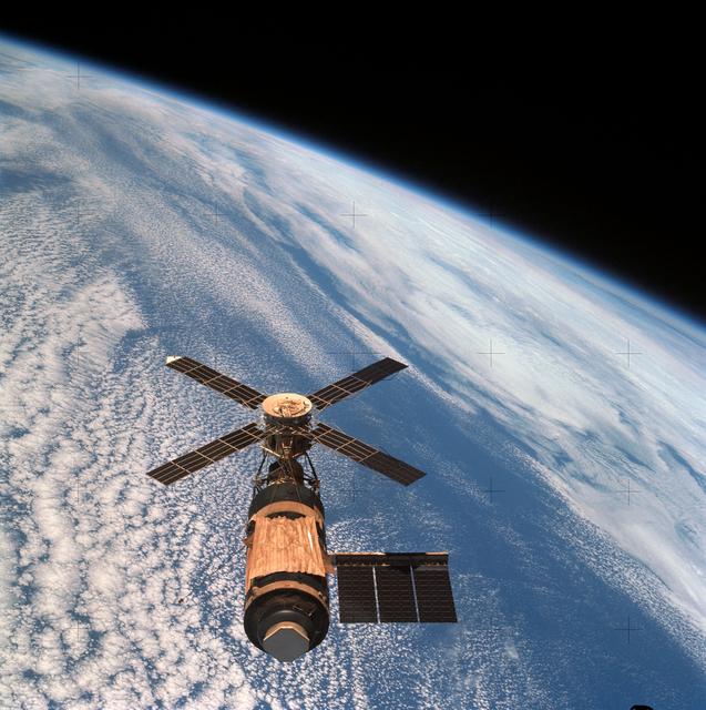
This view of the Skylab Orbital Space Station was taken from the Skylab 2 Command/Service Module during it's initial fly around inspection. The micrometeoroid shield can be seen to be missing and a parasol solar shield was later fitted in i…
Rendezvous and Fly Around Inspection of Skylab I Orbital Space Station
S77-E-5073 (22 May 1996) --- From its position at 175 statute miles above Earth, the Space Shuttle Endeavour has encountered some colorful and attractive scenes heading into sunsets and sunrises.  This particular encounter, captured with an…
Sunrise seen from STS-77
The European Retrievable Carrier 1L (EURECA-1L) spacecraft, with solar array panels extended, drifts above the Earth after deployment from the payload bay of Atlantis, Orbiter Vehicle (OV) 104, during STS-46. EURECA's onboard propulsion uni…
EURECA-1L drifts above the Earth surface after STS-46 deployment from OV-104
Behold one of the more detailed images of the Earth yet created. This Blue Marble Earth montage shown above -- created from photographs taken by the Visible/Infrared Imager Radiometer Suite (VIIRS) instrument on board the new Suomi NPP sate…
Earth
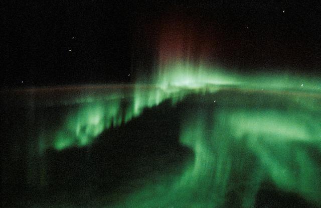
STS-45 Earth observation taken onboard Atlantis, Orbiter Vehicle (OV) 104, is of the Aurora Australis or Southern Lights. The STS-45 crewmembers note the interesting spiralling or corkscrew appearance of this particular sighting. Aurorae we…
STS-45 Earth observation of the Aurora Australis or Southern Lights
SL2-4-265 (25 May 1973) --- Skylab 2, approach to Skylab at long range, fly-around inspection. Orbital Workshop with area of missing micrometeoroid shield visible and partially deployed solar array visible. Photo credit: NASA
Rendezvous and Fly Around Inspection of Skylab I Orbital Space Station
STS006-46-617 (4-9 April 1983) --- This view of sunset over the Amazon Basin was photographed with a 35mm camera from the Earth-orbiting space shuttle Challenger. The reusable vehicle was making its first trip into space and carried a crew…
Earth limb at sunset
Every day of every year, NASA satellites provide useful data about our home planet, and along the way, some beautiful images as well. This video includes satellite images of Earth in 2014 from NASA and its partners as well as photos and a t…
Earth from Orbit 2014
In this photograph, Jeff Alden (left) and Justin O'Cornor, two middle school students at Lane Middle School in Portland, Oregon are demonstrating their Earth-to-Orbit (ETO) Design Challenge project at NASA Marshall Space Flight Center (MSFC…
Around Marshall
This photograph from northwestern New Mexico shows a ridge roughly 30 feet about 10 meters tall that formed from lava filling an underground fracture then resisting erosion better than the material around it did.  The dike extends from a vo…
Wing Dike of Hardened Lava in New Mexico
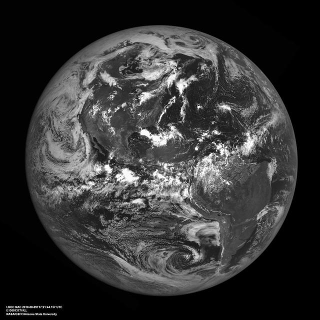
The western hemisphere of our home planet Earth. North (upper left), Central, and South America (lower right) were nicely free of clouds when LRO pointed home on 9 August 2010 to acquire this beautiful view. LROC NAC E136013771.  As LRO orb…
Americas from the Moon
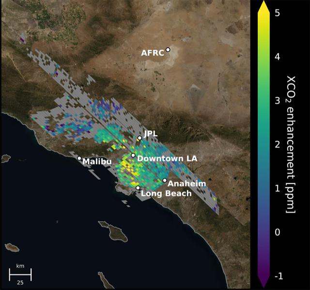
This animation shows the accumulation of five adjoining swaths of data over the Los Angeles metropolitan area that when combined, create a map of carbon dioxide (CO2) concentrations that covers about 50 square miles (80 square kilometers).…
Carbon Dioxide Over the L.A. Metropolitan Area
The launch gantry, surrounding the United Launch Alliance Delta II rocket with the Orbiting Carbon Observatory-2 OCO-2 satellite onboard, is seen at Space Launch Complex 2, Sunday, June 29, 2014, Vandenberg Air Force Base, Calif.
Orbiting Carbon Observatory-2 Ready to Blast Off
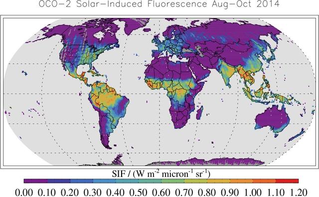
This map shows solar-induced fluorescence, a plant process that occurs during photosynthesis, from Aug. through Oct. 2014 as measured by NASA Orbiting Carbon Observatory-2.
Global Solar-Induced Fluorescence
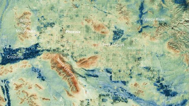
Researchers at NASA's Jet Propulsion Laboratory have created a series of maps showing land-surface temperatures in the Phoenix area in July 2023, when the city experienced a record-breaking run of hot weather. The images reveal the cumulati…
Phoenix Land-Surface Temperatures Documented Amid Record Heat
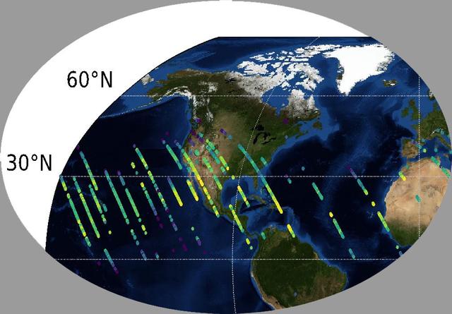
This image shows CO2 over the United States during OCO-3's first few days of science data collection. These initial measurements are consistent with measurements taken by OCO-3's older sibling, OCO-2, over the same area — meaning that even…
OCO-3's First CO2 Measurements
SL4-143-4707 (8 Feb. 1974) --- An overhead view of the Skylab space station cluster in Earth orbit as photographed from the Skylab 4 Command and Service Modules (CSM) during the final fly-around by the CSM before returning home. The space s…
View of Skylab space station cluster in Earth orbit from CSM
The striking views provided by the Bahama Islands lend insights into the important problems of limestone (CaCO3) production and transport. This photograph includes the southern part of Eleuthera Island in the northern Bahamas. The hook-shap…
Eleuthera Island, Bahamas seen from STS-66
STS047-20-015 (12-20 Sept. 1992) --- This 35mm frame represents one of the more spectacular views of Aurora Australis, photographed by the crew. The crew observed and photographed a great deal of auroral activity from the Earth-orbiting Spa…
STS-47 view of the Aurora Australis
S75-30515 (18 July 1975) --- President Gerald R. Ford watches ASTP crewmen Thomas P. Stafford, Donald K. Slayton and Valeriy N. Kubasov on television as he talks to them via radio-telephone while they orbited Earth on July 18, 1975. The Ame…
President Gerald Ford talks to ASTP crewmen via radio-telephone
This close-up view of the intensively cultivated Nile River flood plain near Cairo presents a sharp color contrast to the virtually non-vegetated, sandy desert, located to the west of the vegetated area. Some rectangular cultivated field pa…
Cairo, Egypt/Nile River viewed from STS-66 Atlantis
These images of Earth were reconstructed from photos taken by three smartphones in orbit, or "PhoneSats." The trio of PhoneSats launched on April 21, 2013, aboard the Antares rocket from NASA's Wallops Flight Facility and ended a…
Smartphone Photos From Orbit
This close up view of one of the two scientific airlocks on the Skylab Orbital Workshop Section was taken from the Skylab 2 Command/Service Module during its initial fly around inspection. The micrometeoroid shield can be seen to be missing…
One of the Two Scientific Airlocks on the Orbital Workshop Section
STS-36 Earth observation shows sun beaming off ocean waters with heavy cloud cover.
STS-36 Earth observation of sun beaming off cloud-covered ocean waters
SL2-07-651 (22 June 1973) --- This overhead view of the Skylab Space Station was taken from the Departing Skylab Command/Service Module during the Skylab 2's final fly-around inspection. The single solar panel is quite evident as well as th…
Skylab 2 Farewell View from the Departing Skylab Command/Service Module
Three days after the Mars Reconnaissance Orbiter Aug. 12, 2005, launch, the NASA spacecraft was pointed toward Earth and the Mars Color Imager camera was powered up to acquire a suite of color and ultraviolet images of Earth and the Moon.
Calibration Image of Earth by Mars Color Imager
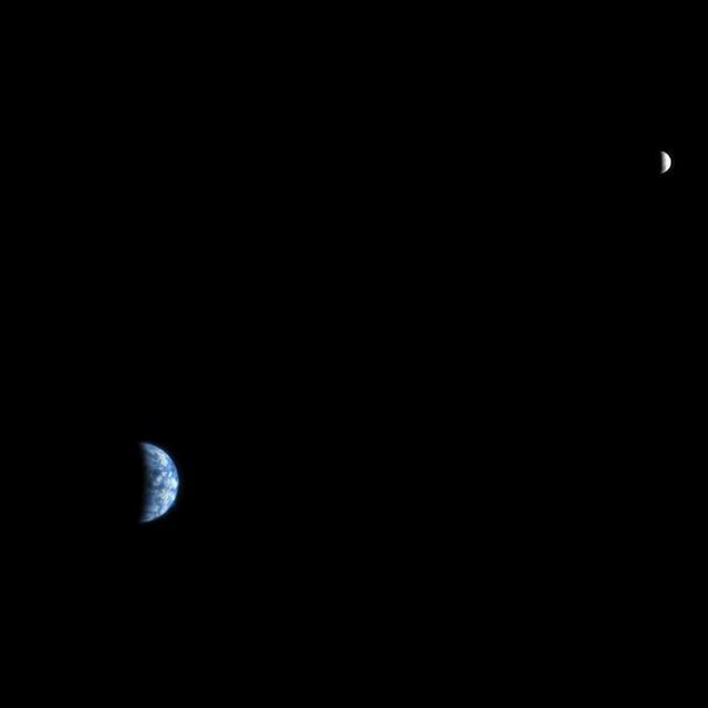
The High Resolution Imaging Science Experiment HiRISE camera would make a great backyard telescope for viewing Mars, and we can also use it at Mars to view other planets. This is an image of Earth and the moon, acquired on October 3, 2007.
Earth and Moon as Seen from Mars
This illustration highlights key events in the launch of NASA Orbiting Carbon Observatory-2, beginning with its liftoff from Vandenberg Air Force Base in central California.
Key Events in the Launch of NASA Orbiting Carbon Observatory-2
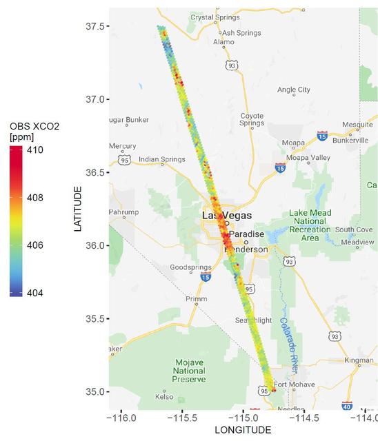
A spatial map of the amount of carbon dioxide (CO2) present in columns of the atmosphere below NASA's Orbiting Carbon Observatory-2 (OCO-2) satellite as it flew over Las Vegas on Feb. 8, 2018. Warmer colors over the city center indicate hig…
NASA's OCO-2 Instrument Measures Atmospheric Carbon Dioxide
Global atmospheric carbon dioxide concentrations from Oct. 1 through Nov. 11, as recorded by NASA Orbiting Carbon Observatory-2.
Global Atmospheric Carbon Dioxide
This composite image of Earth and its moon, as seen from Mars, combines the best Earth image with the best moon image from four sets of images acquired on Nov. 20, 2016, by the High Resolution Imaging Science Experiment (HiRISE) camera on N…
Earth and Its Moon, as Seen From Mars
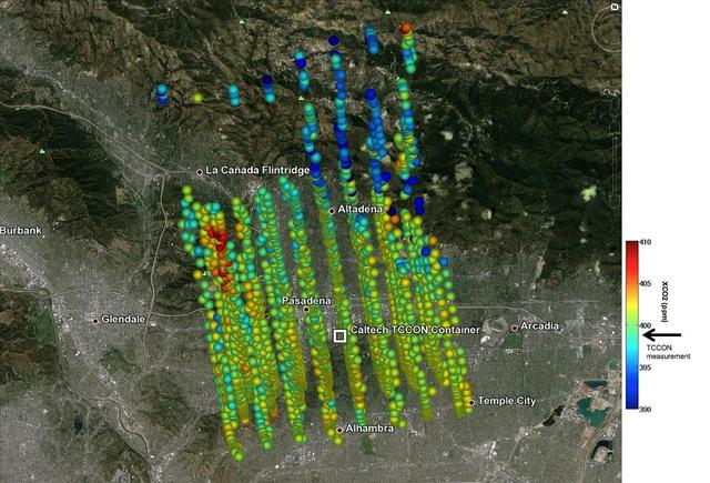
This image shows NASA OCO-2 measurements of carbon dioxide levels over Pasadena and the northern Los Angeles basin on Sept. 5, 2014. Each colored dot represents a single measurement of the greenhouse gas made during an overflight of the are…
Validating Carbon Dioxide Measurements from NASA OCO-2 Over Los Angeles
SL4-143-4706 (8 Feb. 1974) --- An overhead view of the Skylab space station cluster in Earth orbit as photographed from the Skylab 4 Command and Service Modules (CSM) during the final fly-around by the CSM before returning home. The space s…
View of Skylab space station cluster in Earth orbit from CSM
Earth observations taken during the STS-75 mission from the space shuttle Columbia.
Earth observations taken during STS-75
One of the world's most active volcanoes, Sakura-jima in southern-most Kyushu, Japan, erupts dozens of times a year. Volcanic eruptions are so much a part of of daily life in the city of Kagoshima (across the bay and west of Sakura-jima), t…
Sakura-jima volcano in Japan as seen from STS-66 Atlantis
The Exmouth Gulf, western Australia, is bounded on the west by the Cape Ranges; near the base of the peninsula the Learmonth Airfield, site of a solar observatory, can be seen. Spit-accretion ridges formed on ancient beaches extend along th…
Exmouth Gulf, Australia as seen from STS-67 Endeavour
The northwest-southeast trending, snow-covered, linear mountain range is the King Ata Tag Mountain, located in extreme western most China. Highest peaks are just over 20,100 feet above sea level. The town or village of Muji is located in th…
King Ata Tag Mountain Range, western China as seen by STS-66 Atlantis
STS-32 crew took this view of the moon setting over the Earth's limb. Near the center is a semi-vortex in the clouds - a storm system in the early stages of formation. The moon's image is distorted due to refraction through the Earth's atmo…
STS-32 view of the moon setting over the Earth's limb
STS009-11-675 (December 1983) --- The Space Shuttle Columbia passes into a brilliant sunrise scene during the STS-9\Spacelab 1 mission.  The photograph was taken with a 35mm camera aimed through Columbia's aft flight deck windows.  Part of…
Earth limb at sunrise