STS059-52-029 (9-20 April 1994) --- The constellation Orion is backdropped against a colorful display of the Southern Lights (aurora australis) in this 35mm image.  Six NASA astronauts went on to spend a week and a half aboard the Space Shu…
Aurora over Earth limb
STS59-215-022 (12 April 1994) --- This 70mm frame, photographed through the aft flight deck windows of the Space Shuttle Endeavour, features the Space Radar Laboratory (SRL) payload in the cargo bay.  An area of the Pacific Ocean northeast…
View of STS-59 Endeavour's payload bay featuring Space Radar Laboratory
STS059-09-021 (9-20 April 1994) --- Astronaut Thomas D. Jones, mission specialist, monitors a number of cameras fixed on targets of opportunity as the Space Shuttle Endeavour orbits Earth.  Jones is one of six NASA astronauts supporting the…
Astronaut Thomas Jones monitors cameras on targets of opportunity
S93-42727 (26 Aug 1993) --- The six astronauts in training for the STS-59 mission are given some onboard Earth observations tips by Justin Wilkinson (standing, foreground) of the Space Shuttle Earth Observations Project (SSEOP) group.  Astr…
STS-59 crewmembers in training for onboard Earth observations
STS059-306-034 (9-20 April 1994) --- The radiating transportation pattern of this 20th-Century urban plan is nicely displayed in this high-resolution photograph.  Light-toned spots in the desert mark oil well sites; along the south edge of…
Earth observations taken by the STS-59 crew
STS059-213-019 (9-20 April 1994) --- SRL scientists will use these photographs with the radar imagery to discriminate among different ages of basalt flows, and different ecosystems of shrub communities, on these equatorial volcanic islands.…
Isabela, Galapagos Islands as seen from STS-59
STS059-S-085 (18 April 1994) --- This is a three-dimensional perspective view of part of Isla Isabela in the western Galapagos Islands.  It was taken by the L-Band radar in HH polarization from the Spaceborne Imaging Radar-C and X-Band Synt…
Three dimensional perspective view of portion of western Galapagos Islands
STS059-305-021 (9-20 April 1994) --- The floating airport at Osaka, Honshu, Japan.  Nikon photograph, 300mm lens.
Floating airport at Osaka, Honshu, Japan
STS059-L22-140 (9-20 April 1994) --- View northeastward across Uzbekastan to the partly-ice-covered Aral Sea and Kazakhstan.  The irrigated fan-delta of the Amu Darya extends from the right side of the photograph to end in extensive salt fl…
Aral Sea in Uzbekastan seen from STS-59
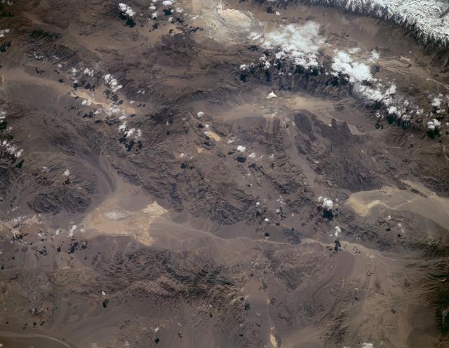
STS059-220-041 (9-20 April 1994) --- View to the south by southwest across the southern Gobi Desert (China) across the Chi-Lien-Shan or Quilienshan or Nanshan (Mountains) in Gansu Province to Lake Quinghai or Ch'ing-Hai (orthography varies…
Gobi Desert, China as seen from STS-59
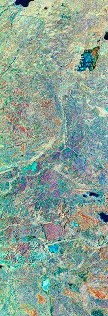
STS059-S-039 (11 April 1994) --- This is a false-color composite of Prince Albert, Canada, centered at 53.91 north latitude and 104.69 west longitude.  This image was acquired by the Spaceborne Imaging Radar-C and X-Band Synthetic Aperture…
False-color composite image of Prince Albert, Canada
STS059-S-068 (13 April 1994) --- This false-color L-Band image of the Manaus region of Brazil was acquired by the Spaceborne Imaging Radar-C and X-Band Synthetic Aperture Radar (SIR-C/X-SAR) aboard the Space Shuttle Endeavour on orbit 46 of…
False-color L-band image of Manaus region of Brazil
STS059-58-018 (9-20 April 1994) --- Part of the Space Shuttle Endeavour and its Space Radar Laboratory (SRL-1) payload are backdropped against a colorful display of the Southern Lights (aurora australis). The vehicle was firing a reaction c…
Endeavour and its SRL-1 payload backdropped against the Southern Lights
STS059-225-072 (9-20 April 1994) --- Orient with the tuning fork away from the viewer (sunglint is always south of the spacecraft at this latitude).  Then the South Fork (left) and North Fork (right) of the Shenandoah meet in the foreground…
Earth observations taken during the STS-59 mission
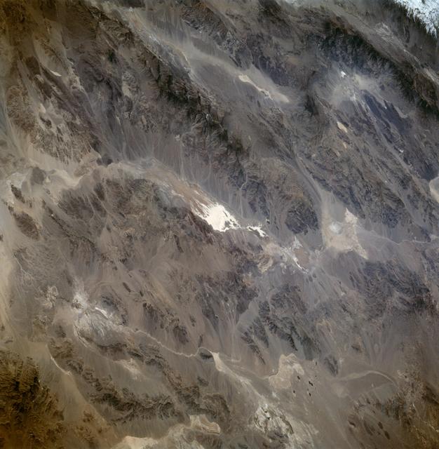
STS059-86-059 (9-20 April 1994) --- This oblique handheld Hasselblad 70mm photo shows Death Valley, near California's border with Nevada.  The valley -- the central feature of Death Valley National Monument -- extends north to south for som…
Death Valley California as seen from STS-59
STS059-209-081 (9-20 April 1994) --- Lake Balkhash, in eastern Kazakhstan, is some 300 miles long.  The lake, frozen in this scene, thawed noticeably during the mission.  The shape of the lake is controlled by the delta of the Ili River, wh…
Lake Balkhash, Kazakhstan seen from STS-59
STS059-L09-162 (9-20 April 1994) --- Orient with the snow-covered mountains (Sierra Nevada of California) in the upper right corner.  Then Owens Valley runs along the top of the photograph to Owens Lake playa at top center.  The upper end o…
Sierra Nevada, California as seen from STS-59
STS059-219-065 (9-20 April 1994) --- The narrow end of the island is to the north by northeast.  This is one of several volcanic islands extending south by southwest between the southern tip of Kamchatka and Japan.  The exposure was stopped…
Earth observations taken during the STS-59 mission
STS059-46-025 (9-20 April 1994) --- On the Space Shuttle Endeavour's aft flight deck astronaut Jerome (Jay) Apt, mission specialist, uses a handheld 70mm Hasselblad camera to record still scenes of Earth.  Apt, the commander of Endeavour's…
Astronaut Jay Apt uses Hasselblad camera to record earth observations
STS059-81-095 (9-20 April 1994) --- View southwestward across the Kamchatka Peninsula.  The cluster of volcanoes in the middle distance are active, including Klutchevskaya whose summit reaches 15,580 feet.  Changes in volcanic deposits, sno…
Earth observations taken during the STS-59 mission
STS059-S-080 (18 April 1994) --- This is a false-color three frequency image of the Oberpfaffenhofen supersite, an area just south-west of Munich in southern Germany.  The colors show the different conditions that the three radars (X-Band,…
Three frequency false-color image of Oberpfaffenhofen supersite in Germany
STS059-S-074 (15 April 1994) --- This color composite C-Band and L-Band image of the Kilauea volcano on the big island of Hawaii was acquired by the Spaceborne Imaging Radar-C and X-Band Synthetic Aperture Radar (SIR-C/X-SAR) flying on the…
Color composite C-band and L-band image of Kilauea volcanoe on Hawaii
STS059-S-027 (10 April 1994) --- This image is a false-color composite of Raco, Michigan, centered at 46.39 degrees north latitude, 84.88 degrees east longitude.  This image was acquired by the Spaceborne Imaging Radar-C and X-Band Syntheti…
False-color composite image of Raco, Michigan
STS059-S-079 (18 April 1994) --- This is a false-color, three frequency image of Prince Albert, Canada, centered at 53.91 north latitude and 104.69 west longitude.  It was produced using data from the X-Band, C-Band and L-Band radars that c…
Three frequency false-color image of Prince Albert, Canada
STS059-50-003 (9-20 April 1994) --- This 35mm night image of the New York City metropolitan area was captured by the crew of the STS-59 crew during the Space Radar Laboratory (SRL) mission. Scientists studying film from the Space Shuttle En…
Night image of New York City as seen from STS-59 Endeavour
STS059-238-074 (9-20 April 1994) --- The Atlantic Ocean, Straits of Gibraltar, and Alboran Sea (the westernmost portion of the Mediterranean Sea) separate Spain on the left from Morocco on the right.  Algeciras Harbor is the prominent notch…
Earth observations taken during the STS-59 mission
This is a three dimensional perspective view of false-color image of the eastern part of the Big Island of Hawaii. It was produced using all three radar frequencies C-Band and L-Band. This view was constructed by overlaying a SIR-C radar im…
Three dimensional perspective view of false-color image of eastern Hawaii
STS059-213-009 (9-20 April 1994) --- San Francisco Bay.  Orient with the sea up.  The delta of the combined Sacramento and San Joaquin Rivers occupies the foreground, San Francisco Bay the middle distance, and the Pacific Ocean the rest.  V…
San Francisco Bay, California as seen from STS-59
STS059-L14-170 (9-20 April 1994) --- Orient with the sea at the left.  Then Subic Bay is at the lower left corner, and Clark Air Force Base (abandoned after the eruption) is to the lower right of the volcano.  A turquoise lake occupies the…
Mount Pinatubo, Philippine Islands as seen from STS-59
STS059-82-010 (9-20 April 1994) --- View northwestward of a small part of southeastern Iraq.  The city of Basra can be seen in the lower left corner, and the former junction of the Tigris and Euphrates Rivers in the upper right.  The stream…
Basra, Iraq as seen from STS-59
STS059-13-030 (9-20 April 1994) --- From the Space Shuttle Endeavour's aft flight deck, astronauts Kevin P. Chilton, pilot, and Linda M. Godwin, payload commander, monitor and photograph clouds on Earth.  The two, along with four other NASA…
Astronauts Chilton and Godwin monitor and photograph clouds on earth
STS059-154-160 (9-20 April 1994) --- Orient with Mono Lake, California at the lower right; then the view is westward across the Sierra Nevada into the San Joaquin River drainage.  A tiny network of ski trails can be seen on the Mono Lake si…
Mono Lake, California as seen from STS-59
STS059-S-072 (13 April 1994) --- This image is a false-color composite of Oetztal, Austria located in the Central Alps, centered at 46.8 degrees north latitude, and 10.70 degrees east longitude, at the border between Switzerland (top), Ital…
False-color composite of Oetztal, Austria
STS059-S-026 (11 April 1994) --- This is an image of Death Valley, California, centered at 36.629 degrees north latitude, 117.069 degrees west longitude.  The image shows Furnace Creek alluvial fan and Furnace Creek Ranch at the far right,…
Death Valley, California
STS059-S-086 (18 April 1994) --- This is a three-frequency false-color image of Flevoland, the Netherlands, centered at 52.4 degrees north latitude, and 5.4 degrees east longitude.  This image was acquired by the Spaceborne Imaging Radar-C…
Three frequency false color image of Flevoland, the Netherlands
STS059-S-084 (17 April 1994) --- This is a three-dimensional perspective of Mammoth Mountain, California.  This view was constructed by overlaying a SIR-C radar image on a U.S. Geological Survey digital elevation map.  Vertical exaggeration…
Three dimensional perspective view of Mammoth Mountain, California
No more images