
NASA CloudSat spacecraft sits encapsulated within its Boeing Delta launch vehicle dual payload attach fitting at Vandenberg Air Force Base, Calif.
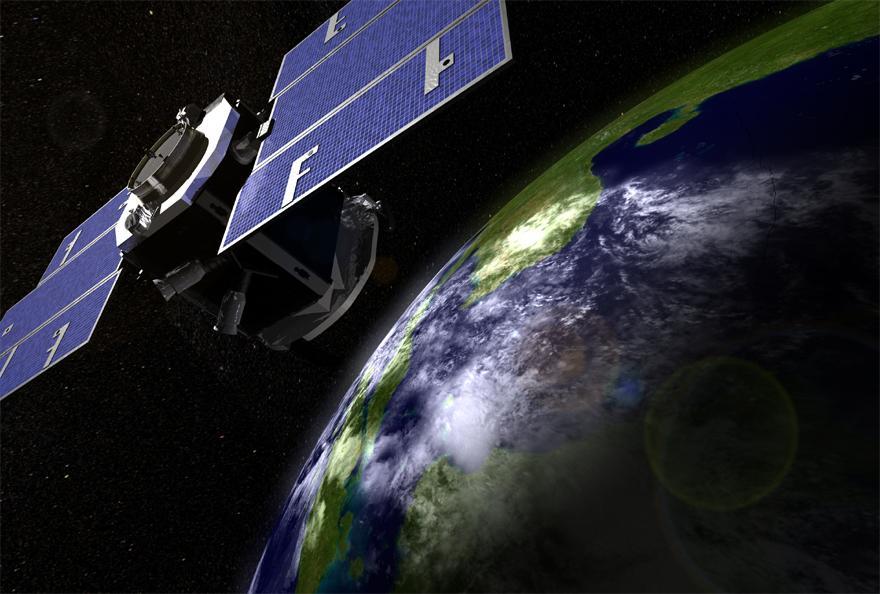
Artist concept of NASA CloudSat spacecraft, which will provide the first global survey of cloud properties to better understand their effects on both weather and climate.
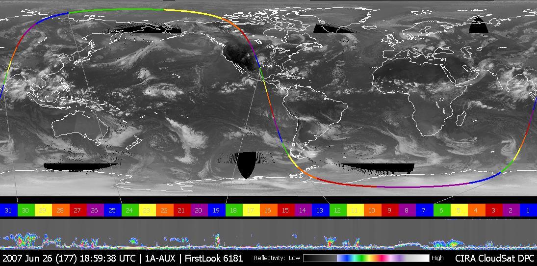
This image was taken on June 26, 2007, UTC 20:00. In this image an obvious storm hangs over the middle of the United States. Figure 1 shows NASA CloudSat data looking, in profile, at the cloud in this storm.

NASA CloudSat satellite completed a stunning eye overpass of Typhoon Dolphin in the western Pacific Ocean on May 16, 2015, at 0407 UTC.

NASA CloudSat spacecraft overpassed Hurricane Sandy on Oct. 29, 2012 just as Sandy was approaching the Atlantic coastline. Sandy contained estimated maximum sustained winds of 90 miles per hour 78 knots.
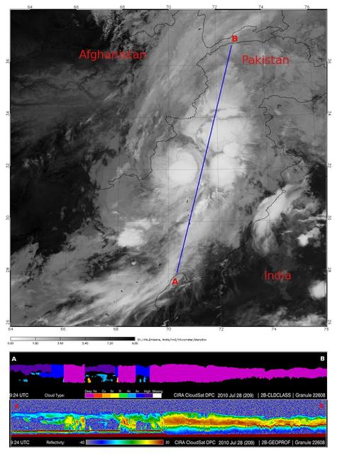
In late July 2010, flooding caused by heavy monsoon rains began in several regions of Pakistan. This image from NASA Aqua spacecraft reveals the bright white cloud tops from the cluster of thunderstorms.
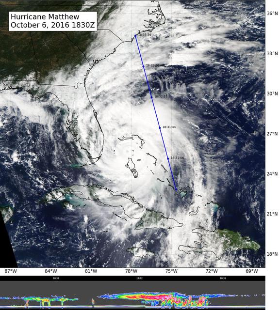
NASA's CloudSat flew east of Hurricane Matthew's center on Oct. 6 at 11:30 a.m. PDT (2:30 p.m. EDT), intersecting parts of Matthew's outer rain bands and revealing Matthew's anvil clouds (thick cirrus cloud cover), with cumulus and cumuloni…
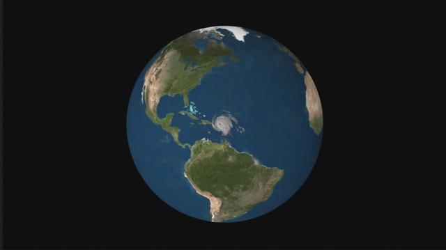
NASA's CloudSat satellite flew over Hurricane Irma on Sept. 6, 2017 at 1:45 p.m. EDT (17:45 UTC) as the storm was approaching Puerto Rico in the Atlantic Ocean. Hurricane Irma contained estimated maximum sustained winds of 185 miles per hou…

VANDENBERG AIR FORCE BASE, CALIF. - At NASA Space Launch Complex 2 on Vandenberg Air Force Base in California, another Solid Rocket Booster is attached to the Boeing Delta II rocket seen behind it. The Delta is the launch vehicle for the…

VANDENBERG AIR FORCE BASE, CALIF. - One of four Solid Rocket Boosters for the CALIPSO_CloudSat launch is raised off the transporter to a vertical position. It will be lifted into the mobile service tower, or gantry, and attached to the Boe…

VANDENBERG AIR FORCE BASE, CALIF. - One of four Solid Rocket Boosters for the CALIPSO_CloudSat launch arrives at NASA Space Launch Complex 2 on Vandenberg Air Force Base in California. It will be lifted into the mobile service tower, or g…

VANDENBERG AIR FORCE BASE, CALIF. - At NASA Space Launch Complex 2 on Vandenberg Air Force Base in California, one half of the fairing for CALIPSO_CloudSat is ready to be lifted into the mobile service tower, or gantry. The fairing enclos…

VANDENBERG AIR FORCE BASE, CALIF. - At NASA Space Launch Complex 2 on Vandenberg Air Force Base in California, the first stage of the Boeing Delta II rocket for the CALIPSO_CloudSat launch arrives on the pad. It will be raised to vertic…

VANDENBERG AIR FORCE BASE, CALIF. - At NASA Space Launch Complex 2 on Vandenberg Air Force Base in California, another Solid Rocket Booster is ready to be attached to the Boeing Delta II rocket seen behind it. The Delta is the launch vehi…

VANDENBERG AIR FORCE BASE, CALIF. - At NASA Space Launch Complex 2 on Vandenberg Air Force Base in California, workers prepare the interstage for the Boeing Delta II rocket to be lifted up the mobile service tower, or gantry. Then it will…
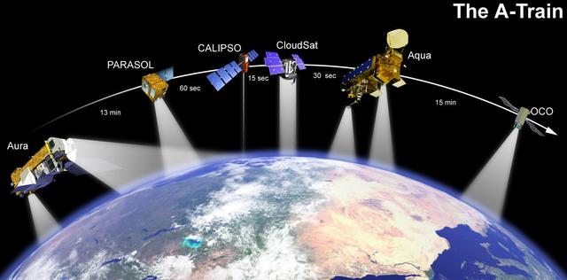
This artist concept shows how NASA’s CALIPSO and CloudSat will fly in formation with other Earth Observing Satellites.

This is an artist concept depicting NASA CloudSat in orbit around Earth.
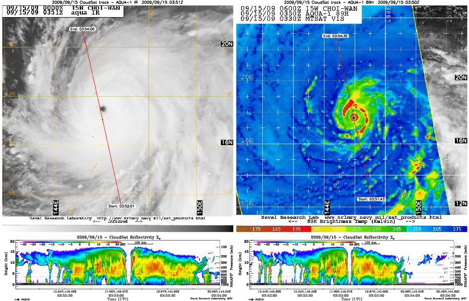
NASA CloudSat satellite captured an eye overpass of Super Typhoon Choi-Wan in the Western Pacific on September 15, 2009 at 0352Z.
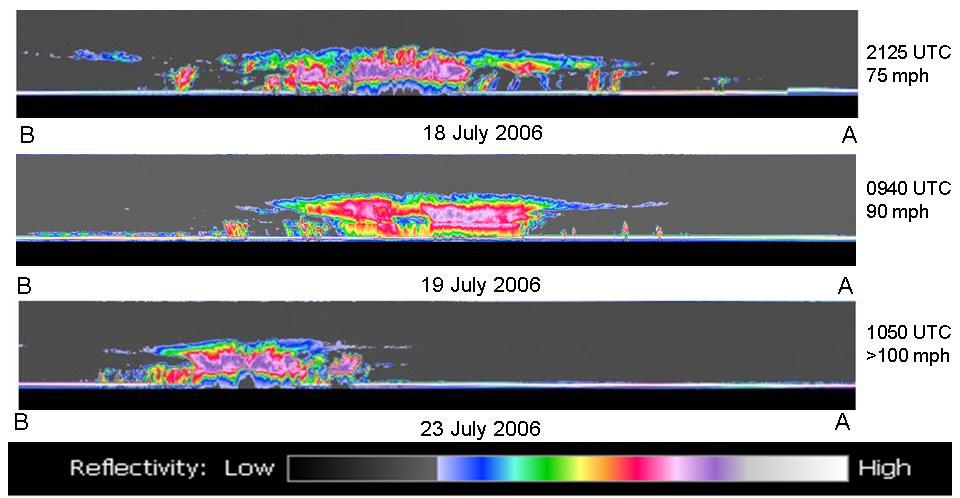
Hurricane Daniel intensified between July 18 and July 23rd. NASA new CloudSat satellite was able to capture and confirm this transformation in its side-view images of Hurricane Daniel as seen in this series of images
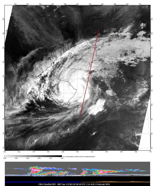
The image of Tropical Cyclone Gonu in the upper panel was taken by the Moderate Resolution Imaging Spectroradiometer MODIS instrument on NASA Aqua satellite on June 5, 2007, at approximately 20:20 UTC.

NASA CloudSat passed over Sandy at 10:32 a.m. EDT on Oct. 27, 2012. Light to moderate precipitation associated with parts of the outer bands of Hurricane Sandy were moving on shore into parts of North Carolina.
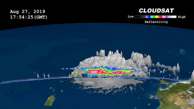
On, Aug. 27, 2019 NASA's CloudSat satellite passed over Dorian, still a tropical storm at the time, near Puerto Rico. CloudSat uses an advanced cloud-profiling radar that "slices" through clouds giving us the ability to see how tall they ar…
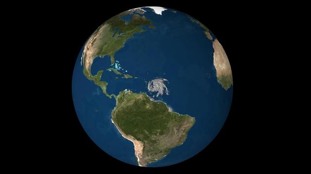
NASA's CloudSat satellite flew over Hurricane Maria on Sept. 17, 2017, at 1:23 p.m. EDT (17:23 UTC) as the storm had just strengthened into a hurricane in the Atlantic Ocean. Hurricane Maria contained estimated maximum sustained winds of 75…
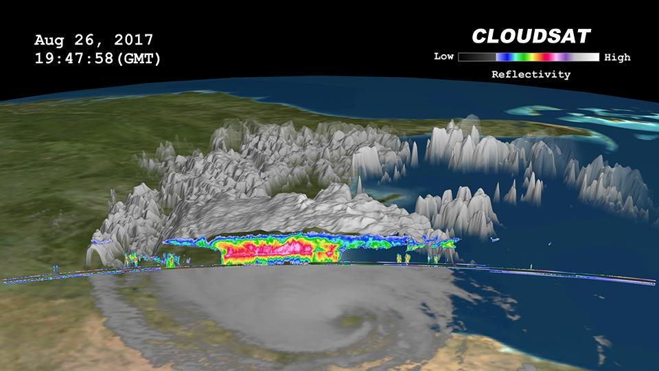
Click on the image for larger animation NASA's CloudSat satellite flew over then-Tropical Storm Harvey on Aug. 26, 2017, at 2:45 p.m. CDT (19:45 UTC) as the storm was nearly stationary over south Texas. At that time, Harvey contained estim…

VANDENBERG AIR FORCE BASE, CALIF. - At NASA Space Launch Complex 2 on Vandenberg Air Force Base in California, the Boeing Delta II rocket, launch vehicle for the CALIPSO_CloudSat spacecraft, is ready to lifted into the mobile service tower…

VANDENBERG AIR FORCE BASE, CALIF. - At NASA Space Launch Complex 2 on Vandenberg Air Force Base in California, the first stage of the Boeing Delta II rocket, launch vehicle for the CALIPSO_CloudSat spacecraft, is raised off the transporter…

VANDENBERG AIR FORCE BASE, CALIF. - At NASA Space Launch Complex 2 on Vandenberg Air Force Base in California, the Boeing Delta II rocket, launch vehicle for the CALIPSO_CloudSat spacecraft, is prepared for lifting into the mobile service…

VANDENBERG AIR FORCE BASE, CALIF. - At NASA Space Launch Complex 2 on Vandenberg Air Force Base in California, the interstage for the Boeing Delta II rocket is lifted up the mobile service tower, or gantry. There it will be mated with the…

VANDENBERG AIR FORCE BASE, CALIF. — At NASA Space Launch Complex 2 on Vandenberg Air Force Base in California, workers get ready to raise the first stage of the Boeing Delta II rocket, launch vehicle for the CALIPSO_CloudSat spacecraft. O…

VANDENBERG AIR FORCE BASE, CALIF. - At NASA Space Launch Complex 2 on Vandenberg Air Force Base in California, the first stage of the Boeing Delta II rocket, launch vehicle for the CALIPSO_CloudSat spacecraft, begins to be lifted into the…
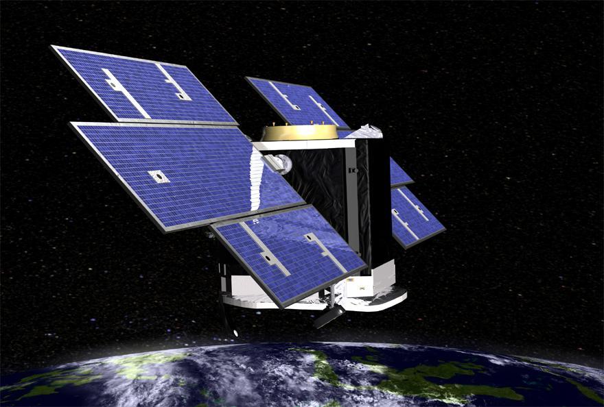
Artist concept of NASA CloudSat spacecraft, which will provide the first global survey of cloud properties to better understand their effects on both weather and climate.

This artist concept shows NASA CloudSat spacecraft and its Cloud Profiling Radar using microwave energy to observe cloud particles and determine the mass of water and ice within clouds.

NASA CloudSat image of a horizontal cross-section of a polar night storm near Antarctica.

NASA new CloudSat satellite captured its first tropical storm, Alberto, as it spun over the Gulf of Mexico the morning of June 12, 2006.
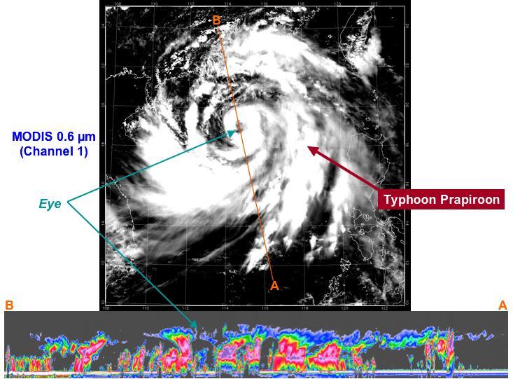
At approximately 0553 UTC 1:53 am EDT, on 2 Aug 2006, NASA CloudSat flew over the eye of Typhoon Prapiroon as it approached southern China.

NASA CloudSat first image, of a warm front storm over the Norwegian Sea, was obtained on May 20, 2006.

NASA CloudSat satellite flew over Typhoon Utor in the West Pacific on Aug. 11, 2013 at 0518 UTC, passing within about 6.2 miles 10 kilometers from the center of the storm, and revealing the structure of the storm eye and eyewall.

NASA CloudSat image of a horizontal cross-section of tropical clouds and thunderstorms over east Africa.
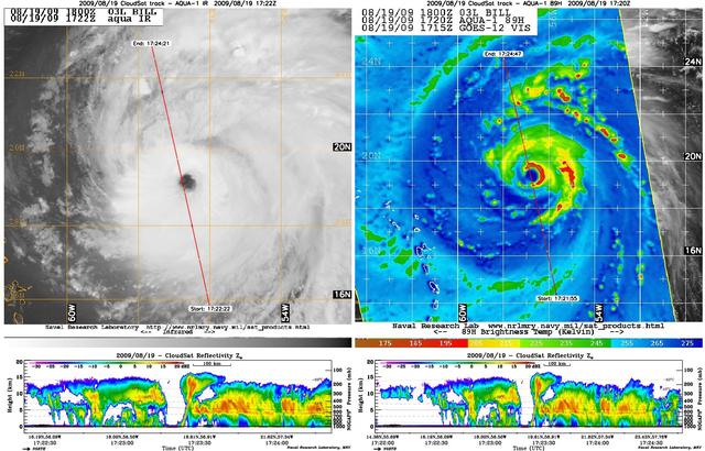
NASA satellite CloudSat captured an extraordinary eye overpass of a category 4 Hurricane Bill on August 19, 2009 at 1720 UTC 1220 EDT. Bill maximum sustained winds are 132 mph 115 knots with a central pressure of 947 mb.

The image at the top of figure 1 is from a geostationary imager. The colors relate to the temperature of the clouds. The higher the clouds, the lower the temperature. The highest, coldest clouds are located near the center of the hurricane.
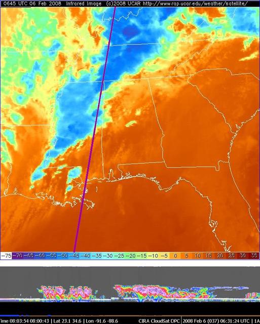
NASA CloudSat made a nighttime overpass approximately 0630 UTC of the thunderstorms responsible for the tornadic outbreak over Kentucky, Tennessee, and Mississippi on Tuesday, February 5, 2008.
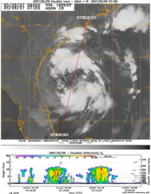
CloudSat's Cloud Profiling Radar captured a profile across Tropical Storm Andrea on Wednesday, May 9, 2007, near the South Carolina/Georgia/Florida Atlantic coast. The upper image shows an infrared view of Tropical Storm Andrea from the Mod…

VANDENBERG AIR FORCE BASE, CALIF. - Another Solid Rocket Booster for the CALIPSO_CloudSat launch is ready to be raised to a vertical position at NASA Space Launch Complex 2 on Vandenberg Air Force Base in California. It will then be lift…

VANDENBERG AIR FORCE BASE, CALIF. - At NASA Space Launch Complex 2 on Vandenberg Air Force Base in California, the first half of the fairing for CALIPSO_CloudSat reaches the top of the mobile service tower, or gantry. The fairing encloses…

VANDENBERG AIR FORCE BASE, CALIF. - At NASA Space Launch Complex 2 on Vandenberg Air Force Base in California, the first stage of the Boeing Delta II rocket for the CALIPSO_CloudSat launch arrives on the pad. It will be raised to vertica…

VANDENBERG AIR FORCE BASE, CALIF. - One of four Solid Rocket Boosters for the CALIPSO_CloudSat launch is ready for lifting into the mobile service tower, or gantry, where it will be attached to the Boeing Delta II rocket. CALIPSO stands fo…

VANDENBERG AIR FORCE BASE, CALIF. - At NASA Space Launch Complex 2 on Vandenberg Air Force Base in California, the interstage for the Boeing Delta II rocket is lifted up the mobile service tower, or gantry. There it will be mated with the…

VANDENBERG AIR FORCE BASE, CALIF. - At NASA Space Launch Complex 2 on Vandenberg Air Force Base in California, the interstage for the Boeing Delta II rocket, launch vehicle for the CALIPSO_CloudSat spacecraft, arrives at the pad. It will…