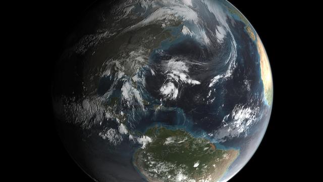
A NASA camera on the Deep Space Climate Observatory satellite has returned its first view of the entire sunlit side of Earth from one million miles away.  This color image of Earth was taken by NASA’s Earth Polychromatic Imaging Camera (EPI…
NASA Captures 'EPIC' Earth Image
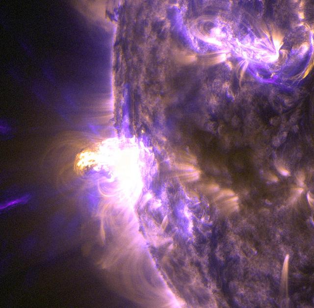
On Aug. 24, 2014, the sun emitted a mid-level solar flare, peaking at 8:16 a.m. EDT. NASA's Solar Dynamics Observatory captured images of the flare, which erupted on the left side of the sun. Solar flares are powerful bursts of radiation. H…
NASA Captures Images of a Late Summer Flare [detail]
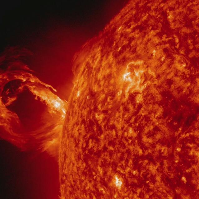
A coronal mass ejection (CME) erupted from just around the edge of the sun on May 1, 2013, in a gigantic rolling wave. CMEs can shoot over a billion tons of particles into space at over a million miles per hour. This CME occurred on the sun…
Gigantic Rolling Wave Captured on the Sun
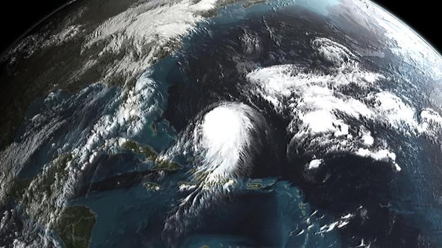
Joaquin became a tropical storm Monday evening (EDT) midway between the Bahamas and Bermuda and has now formed into Hurricane Joaquin, the 3rd of the season--the difference is Joaquin could impact the US East Coast.  NASA's GPM satellite ca…
GPM Captures Hurricane Joaquin
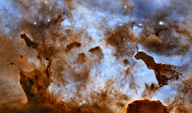
NASA image release September 16, 2010  Enjoying a frozen treat on a hot summer day can leave a sticky mess as it melts in the Sun and deforms. In the cold vacuum of space, there is no edible ice cream, but there is radiation from massive st…
Hubble Captures Cosmic Ice Sculptures
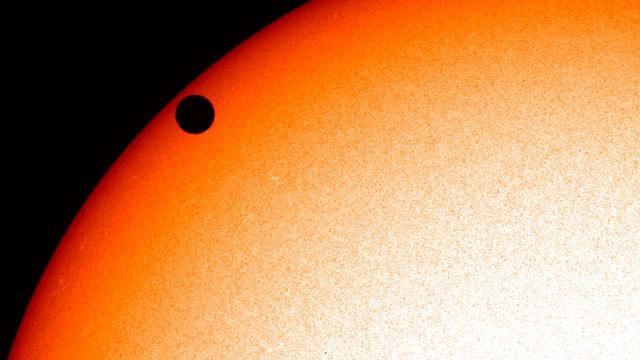
NASA image captured June 5, 2012.  On June 5-6 2012, SDO is collecting images of one of the rarest predictable solar events: the transit of Venus across the face of the sun.  This event happens in pairs eight years apart that are separated…
NASA's SDO Satellite Captures 2012 Venus Transit [Close-Up]
Image release June 22, 2010  A spectacular new NASA/ESA Hubble Space Telescope image — one of the largest ever released of a star-forming region — highlights N11, part of a complex network of gas clouds and star clusters within our neighbou…
Hubble Captures Bubbles And Baby Stars
NASA image captured June 5, 2012.  On June 5-6 2012, SDO is collecting images of one of the rarest predictable solar events: the transit of Venus across the face of the sun.  This event happens in pairs eight years apart that are separated…
NASA's SDO Satellite Captures Venus Transit Approach -- Bigger, Better!
Landsat 7 image of Phoenix, Arizona acquired November 28, 2014.  Landsat 7 is a U.S. satellite used to acquire remotely sensed images of the Earth's land surface and surrounding coastal regions. It is maintained by the Landsat 7 Project Sci…
NASA Satellite Captures Super Bowl Cities - Phoenix [annotated]
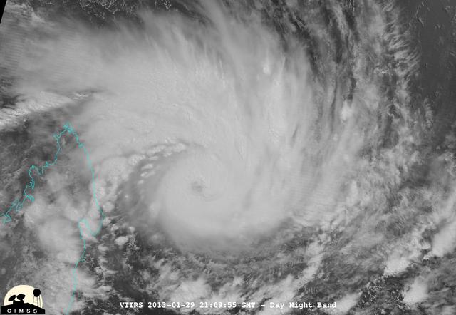
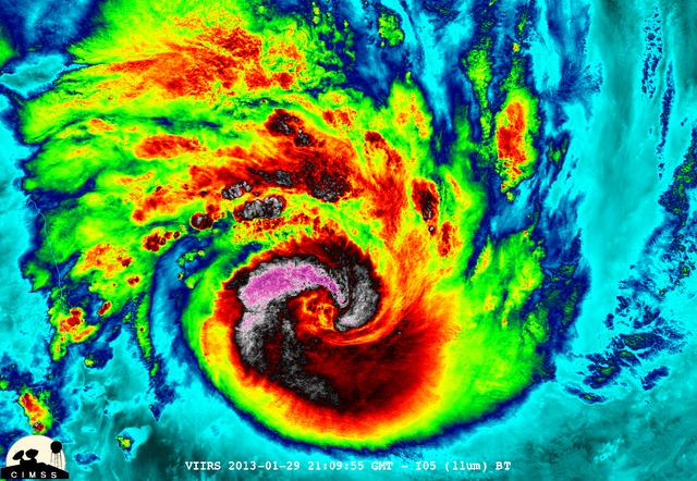
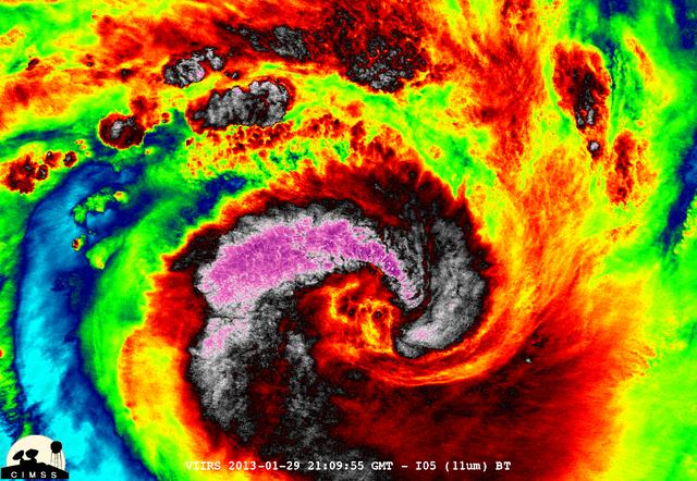
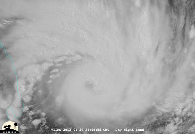
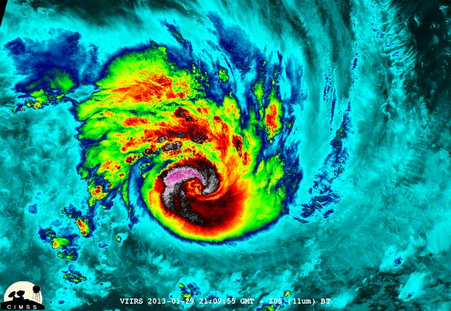
NASA-NOAA's Suomi NPP satellite captured this false-colored night-time image of Cyclone Felleng during the night on Jan. 28, 2013. Felleng is located in the Southern Indian Ocean, and is northwest of Madagascar. The image revealed some pret…
NASA-NOAA's Suomi NPP Satellite Captures Night-time Look at Cyclone Felleng
Landsat 7 image of  Boston/Providence area acquired August 25, 2014.  Landsat 7 is a U.S. satellite used to acquire remotely sensed images of the Earth's land surface and surrounding coastal regions. It is maintained by the Landsat 7 Projec…
NASA Satellite Captures Super Bowl Cities - Boston/Providence
Landsat 7 image of  Boston/Providence area acquired August 25, 2014.  Landsat 7 is a U.S. satellite used to acquire remotely sensed images of the Earth's land surface and surrounding coastal regions. It is maintained by the Landsat 7 Projec…
NASA Satellite Captures Super Bowl Cities - Boston/Providence [annotated]
NASA image release April 22, 2010  NASA's Hubble Space Telescope captured this billowing cloud of cold interstellar gas and dust rising from a tempestuous stellar nursery located in the Carina Nebula, 7,500 light-years away in the southern…
Hubble Captures Spectacular "Landscape" in the Carina Nebula
NASA Image acquired March 14 - 15, 2010  Two fierce tropical cyclones raged over the South Pacific Ocean in mid-March 2010, the U.S. Navy’s Joint Typhoon Warning Center (JTWC) reported. Over the Solomon Islands, Tropical Cyclone Ului had ma…
NASA Satellite Captures Tropical Cyclones Tomas and Ului
NASA-NOAA's Suomi NPP satellite captured this false-colored night-time image of Cyclone Felleng during the night on Jan. 28, 2013. Felleng is located in the Southern Indian Ocean, and is northwest of Madagascar. The image revealed some pret…
NASA-NOAA's Suomi NPP Satellite Captures Night-time Look at Cyclone Felleng
NASA-NOAA's Suomi NPP satellite captured this false-colored night-time image of Cyclone Felleng during the night on Jan. 28, 2013. Felleng is located in the Southern Indian Ocean, and is northwest of Madagascar. The image revealed some pret…
NASA-NOAA's Suomi NPP Satellite Captures Night-time Look at Cyclone Felleng
Landsat 7 image of  Denver area acquired Nov 3, 2015.  Landsat 7 is a U.S. satellite used to acquire remotely sensed images of the Earth's land surface and surrounding coastal regions. It is maintained by the Landsat 7 Project Science Offic…
NASA Satellite Captures Super Bowl Cities - Denver, CO
Astronomers are using the NASA/ESA Hubble Space Telescope to study auroras — stunning light shows in a planet’s atmosphere — on the poles of the largest planet in the solar system, Jupiter. This observation program is supported by measureme…
Hubble Captures Vivid Auroras in Jupiter’s Atmosphere
Peering deep into the core of the Crab Nebula, this close-up image reveals the beating heart of one of the most historic and intensively studied remnants of a supernova, an exploding star. The inner region sends out clock-like pulses of rad…
NASA's Hubble Captures the Beating Heart of the Crab Nebula
Less than once per decade, Mercury passes between the Earth and the sun in a rare astronomical event known as a planetary transit. The 2016 Mercury transit occurred on May 9th, between roughly 7:12 a.m. and 2:42 p.m. EDT.  The images in thi…
NASA's SDO Captures Mercury Transit Time-lapses SDO Captures Mercury Transit Time-lapse
Now that NASA's James Webb Space Telescope has moved to NASA's Johnson Space Center in Houston, Texas, a special Webb camera was installed there to continue providing daily video feeds on the telescope's progress.  Space enthusiasts, who ar…
NASA's "Webb-cam" Captures Engineers at Work on Webb at Johnson Space Center
At 19:36 UTC (3:36 p.m. EDT) on June 26, the Visible Infrared Imaging Radiometer Suite (VIIRS) instrument aboard NASA-NOAA's Suomi NPP satellite provided a visible-light image of Hurricane Dora. The VIIRS imagery showed a small hurricane wi…
NASA Captures Hurricane Dora at Peak Strength, Before Weakening Began
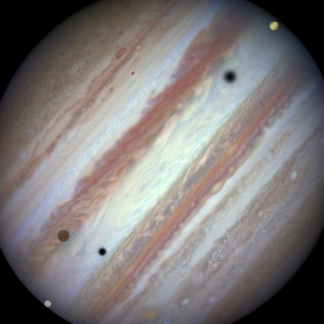
Three moons and their shadows parade across Jupiter near the end of the event at 07:10 UT on January 24, 2015. Europa has entered the frame at lower left. Slower-moving Callisto is above and to the right of Europa. Fastest-moving Io is appr…
Hubble Captures Rare Triple-Moon Conjunction
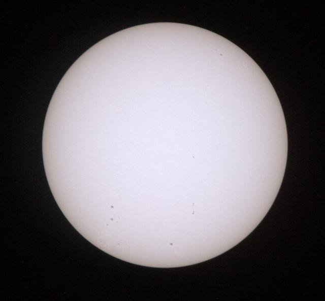
UT154 solar test CO 934_0253  This is a sample low res test image from NASA Astronaut Don Petttit shot from onboard the International Space Station on June 5, 2012.  Petttit, who had the foresight to bring a solar filter for his camera, wil…
Capturing Venus Transit From ISS
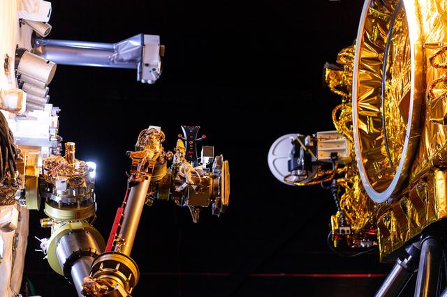
One of the OSAM-1 Robot Arms is seen, mounted onto ground support equipment used for testing inside the cleanroom at Goddard Space Flight Center, Greenbelt Md., Apr 17, 2024. This photo has been reviewed by Maxar, OSAM1 project management,…
GSFC_20230223_RL_010493
NASA-NOAA's Suomi NPP satellite captured this false-colored night-time image of Cyclone Felleng during the night on Jan. 28, 2013. Felleng is located in the Southern Indian Ocean, and is northwest of Madagascar. The image revealed some pret…
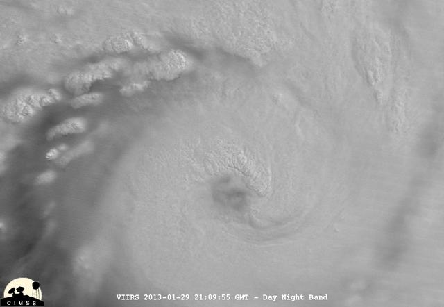
NASA-NOAA's Suomi NPP Satellite Captures Night-time Look at Cyclone Felleng
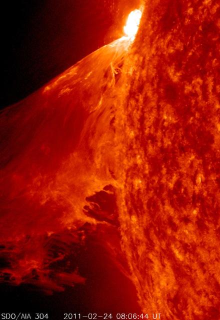
NASA image captured Feb. 24, 2011  To see an image showing the size of the prominence in comparison to the <b><a href="http://www.flickr.com/photos/gsfc/5492781335/">size of earth click here.</a></b>  To view a video of this event go to: <a…
NASA's SDO Captures a Monster Prominence
NASA-NOAA's Suomi NPP satellite captured this false-colored night-time image of Cyclone Felleng during the night on Jan. 28, 2013. Felleng is located in the Southern Indian Ocean, and is northwest of Madagascar. The image revealed some pret…
NASA-NOAA's Suomi NPP Satellite Captures Night-time Look at Cyclone Felleng
NASA image acquired: March 29, 2011  The first image acquired by MESSENGER from orbit around Mercury was actually part of an eight-image sequence, for which images were acquired through eight of the WAC’s eleven filters. Here we see a color…
NASA Captures First Color Image of Mercury from Orbit
Landsat 7 image of Seattle, Washington acquired August 23, 2014.  Landsat 7 is a U.S. satellite used to acquire remotely sensed images of the Earth's land surface and surrounding coastal regions. It is maintained by the Landsat 7 Project Sc…
NASA Satellite Captures Super Bowl Cities - Seattle [annotated]
Landsat 7 image of  the Santa Clara area acquired Nov 16, 2015.  Landsat 7 is a U.S. satellite used to acquire remotely sensed images of the Earth's land surface and surrounding coastal regions. It is maintained by the Landsat 7 Project Sci…
NASA Satellite Captures Super Bowl Cities - Santa Clara, CA
NASA's Aqua satellite passed over Japan one hour and 41 minutes before the quake hit. At the time Aqua passed overhead, the Moderate Resolution Imaging Spectroradiometer (MODIS) instrument captured a visible of Japan covered by clouds. The…
NASA Satellite Image of Japan Captured March 11, 2011
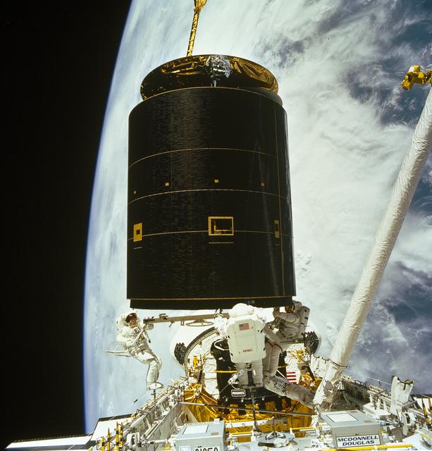
STS-49, the first flight of the Space Shuttle Orbiter Endeavour, lifted off from launch pad 39B on May 7, 1992 at 6:40 pm CDT. The STS-49 mission was the first U.S. orbital flight to feature 4 extravehicular activities (EVAs), and the first…
Space Shuttle Projects
STS-49, the first flight of the Space Shuttle Orbiter Endeavour, lifted off from launch pad 39B on May 7, 1992 at 6:40 pm CDT. The STS-49 mission was the first U.S. orbital flight to feature 4 extravehicular activities (EVAs), and the first…
Space Shuttle Projects
Joaquin became a tropical storm Monday evening (EDT) midway between the Bahamas and Bermuda and has now formed into Hurricane Joaquin, the 3rd of the season--the difference is Joaquin could impact the US East Coast.  NASA's GPM satellite ca…
GPM Captures Hurricane Joaquin
Astronomers using NASA's Hubble Space Telescope have assembled a comprehensive picture of the evolving universe – among the most colorful deep space images ever captured by the 24-year-old telescope.  Researchers say the image, in new study…
Hubble Team Unveils Most Colorful View of Universe Captured by Space Telescope
On Aug. 24, 2014, the sun emitted a mid-level solar flare, peaking at 8:16 a.m. EDT. NASA's Solar Dynamics Observatory captured images of the flare, which erupted on the left side of the sun. Solar flares are powerful bursts of radiation. H…
NASA Captures Images of a Late Summer Flare
By combining the power of a &quot;natural lens&quot; in space with the capability of NASA's Hubble Space Telescope, astronomers made a surprising discovery—the first example of a compact yet massive, fast-spinning, disk-shaped galaxy that s…
Hubble Captures Massive Dead Disk Galaxy that Challenges Theories of Galaxy Evolution
NASA-NOAA's Suomi NPP satellite captured this false-colored night-time image of Cyclone Felleng during the night on Jan. 28, 2013. Felleng is located in the Southern Indian Ocean, and is northwest of Madagascar. The image revealed some pret…
NASA-NOAA's Suomi NPP Satellite Captures Night-time Look at Cyclone Felleng
Landsat 7 image of Seattle, Washington acquired August 23, 2014.  Landsat 7 is a U.S. satellite used to acquire remotely sensed images of the Earth's land surface and surrounding coastal regions. It is maintained by the Landsat 7 Project Sc…
NASA Satellite Captures Super Bowl Cities - Seattle
Landsat 7 image of Phoenix, Arizona acquired November 28, 2014.  Landsat 7 is a U.S. satellite used to acquire remotely sensed images of the Earth's land surface and surrounding coastal regions. It is maintained by the Landsat 7 Project Sci…
NASA Satellite Captures Super Bowl Cities - Phoenix
A corona mass ejection (CME) erupted from just around the edge of the sun on May 1, 2013, in a gigantic rolling wave. CMEs can shoot over a billion tons of particles into space at over a million miles per hour. This CME occurred on the sun’…
Gigantic Rolling Wave Captured on the Sun [hd video]
Detail shot of the OSAM-1 auto-capture test bed performing a test of the robot arm inside the robotics operations center at Goddard Space Flight Center, Greenbelt Md., Feb 23, 2023. This photo has been approved for public release. NASA/Mike…
GSFC_20230223_RL_009841
The sun emitted a trio of mid-level solar flares on April 2-3, 2017. The first peaked at 4:02 a.m. EDT on April 2, the second peaked at 4:33 p.m. EDT on April 2, and the third peaked at 10:29 a.m. EDT on April 3. NASA’s Solar Dynamics Obser…
NASA’s Solar Dynamics Observatory Captured Trio of Solar Flares April 2-3
iss057e105337 (Nov. 19, 2018) --- Northrop Grumman's Cygnus space freighter with its prominent cymbal-shaped UltraFlex solar arrays is pictured in the grips of the Canadarm2 robotic arm after it was captured by Expedition 57 Flight Engineer…
iss057e105337
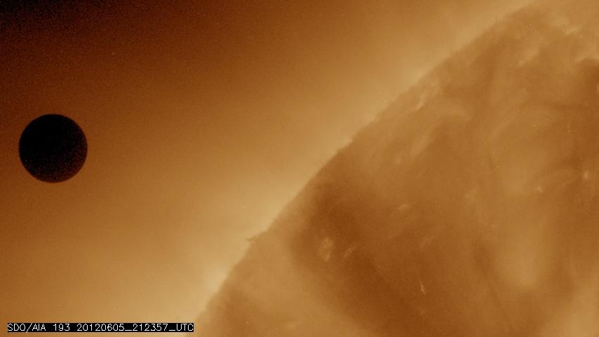
NASA image captured June 5, 2012 at 212357 UTC (about 5:24 p.m. EDT).  On June 5-6 2012, SDO is collecting images of one of the rarest predictable solar events: the transit of Venus across the face of the sun.  This event happens in pairs e…
NASA's SDO Satellite Captures Venus Transit Approach
NASA image captured June 5, 2012.  On June 5-6 2012, SDO is collecting images of one of the rarest predictable solar events: the transit of Venus across the face of the sun.  This event happens in pairs eight years apart that are separated…
NASA's SDO Satellite Captures 2012 Venus Transit
New imagery from the Hubble Space Telescope is revealing details never before seen on Jupiter. Hubble’s new Jupiter maps were used to create this Ultra HD animation.  These new maps and spinning globes of Jupiter were made from observations…
Hubble’s Planetary Portrait Captures New Changes in Jupiter’s Great Red Spot