
The October fires in Northern California were some of the most destructive in the state's history. The burned area on the right side of the image is the ATLAS fire, that burned east of Napa; the fire consumed 51,000 acres and destroyed almo…

An ER-2 based at NASA's Armstrong Flight Research Center in California flew a mission over the state's wildfires Aug. 9 to validate instruments and to collect information to help U.S. Forest Service officials plan for recovery.

Scott Howe, a pilot at NASA's Armstrong Flight Research Center in California, assisted with monitoring California's wildfires by operating a MQ-9 remotely piloted aircraft during launches and recoveries for the California Air National Guard…
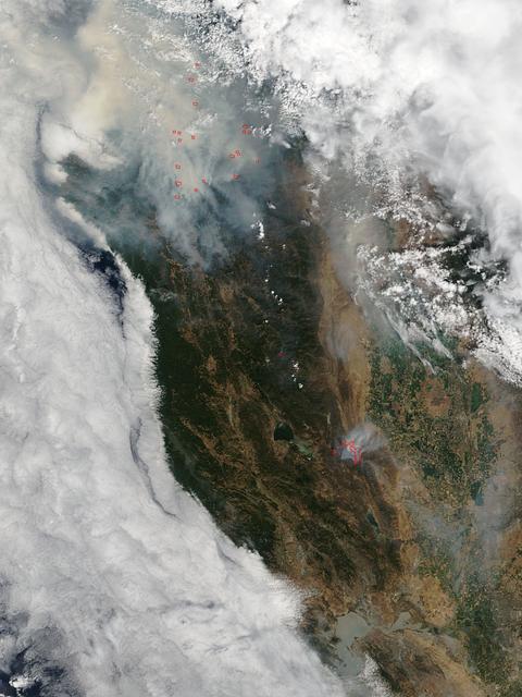
This satellite image shows smoke from several fires in Oregon and California on Aug. 2, 2015. The Moderate Resolution Imaging Spectroradiometer (MODIS) instrument that flies aboard NASA's Aqua satellite captured an image of smoke from these…

NASA’s B200 King Air team includes, from left, principal engineer Cory Hill, operations engineer KC Sujan, pilot Tracy Phelps, crew chief Mario Soto, aircraft technician Ruben Saiza, quality assurance technician Scott Silver, and senior eng…

A pair of Cal Fire UH-1H Super Huey helicopters are seen during an aerial attack on a simulated wildfire, Tuesday, May 4, 2021 as Cal Fire conducts aerial fire fighting training exercises near Redding, California. STEReO, the Scalable Traf…

STEReO, the Scalable Traffic Management for Emergency Response Operations project, team members watch as a Cal Fire UH-1H Super Huey helicopter drops water on a simulated wildfire, Tuesday, May 4, 2021 as Cal Fire conducts aerial fire fight…

STEReO, the Scalable Traffic Management for Emergency Response Operations project, team members watch as a Cal Fire UH-1H Super Huey helicopter drops water on a simulated wildfire, Tuesday, May 4, 2021 as Cal Fire conducts aerial fire fight…

A Cal Fire S2-T airtanker drops water on a simulated wildfire, Tuesday, May 4, 2021, as Cal Fire conducts aerial fire fighting training exercises near Redding, California. STEReO, the Scalable Traffic Management for Emergency Response Oper…

A Cal Fire UH-1H Super Huey helicopter conducts a water drop on a simulated wildfire, Tuesday, May 4, 2021 as Cal Fire conducts aerial fire fighting training exercises near Redding, California. STEReO, the Scalable Traffic Management for E…

NASA Dryden's Ikhana ground crewmen Gus Carreno and James Smith load the thermal-infrared imaging scanner pallet into the Ikhana's underwing payload pod.

NASA Ames engineer Ted Hildum checks out the thermal-infrared scanner computer before it is loaded on NASA's Ikhana unmanned aircraft.

As firefighters continue to work toward full containment of the rash of wildfires burning in Northern California, a new image from the Advanced Spaceborne Thermal Emission and Reflection Radiometer (ASTER) instrument on NASA's Terra satelli…

According to the NBCnews.com, Southern California firefighters were battling a growing, brush-fueled wildfire early Friday that had reached the beach in Ventura County and was pushing toward the upscale city of Malibu, officials said. Dubb…

The fire season in California has been anything but cooperative this year. Hot conditions combined with a state-wide drought and dry lightning makes for unpleasant conditions and leads to an abundance of forest fires. On August 12, lightn…

The winter of 2013 was among the driest on record for California, setting the stage for an active fire season. By August 26, the Rim Fire had made its way into the record books. At just 15 percent contained, the fire is now the 13th largest…
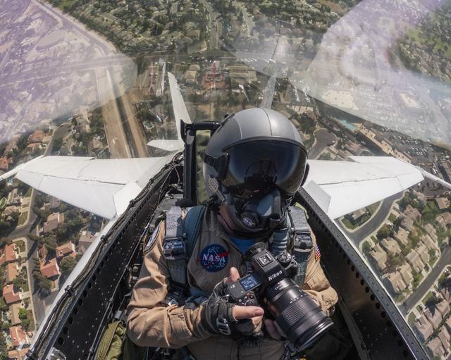
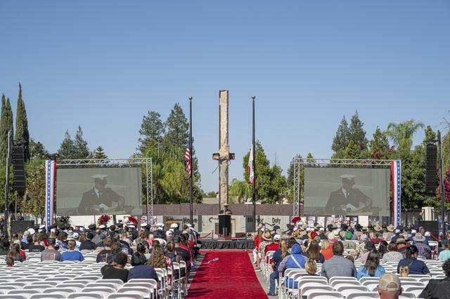
NASA photographer Jim Ross captured this view from inside the cockpit of an F/A‑18 aircraft during a commemorative flyover above the Bakersfield Fire Department and surrounding community in California on Friday, Sept. 11, 2026. The aircraft…

A Cal Fire S2-T airtanker follows a U.S. Forest Service King Air 200 during an aerial attack on a simulated wildfire, Tuesday, May 4, 2021 as Cal Fire conducts aerial fire fighting training exercises near Redding, California. STEReO, the S…

A Cal Fire S2-T airtanker is seen during an aerial attack on a simulated wildfire, Tuesday, May 4, 2021 as Cal Fire conducts aerial fire fighting training exercises near Redding, California. STEReO, the Scalable Traffic Management for Emer…

NASA’s DC-8 flying laboratory carried the Fire Influence on Regional to Global Environments and Air Quality, or FIREX-AQ, science team and a suite of state-of-the-art instrumentation to observe different components of fire smoke in varying…

A Cal Fire S2-T airtanker drops water on a simulated wildfire, Wednesday, May 5, 2021 as Cal Fire conducts aerial fire fighting training exercises near Redding, California. STEReO, the Scalable Traffic Management for Emergency Response Ope…

A Cal Fire S2-T airtanker is seen flying over STEReO, the Scalable Traffic Management for Emergency Response Operations project, team members during field testing, Wednesday, May 5, 2021 as Cal Fire conducts aerial fire fighting training ex…

With smoke from the Lake Arrowhead area fires streaming in the background, NASA's Ikhana unmanned aircraft heads out on a Southern California wildfires imaging mission.
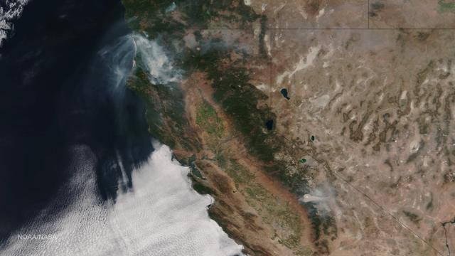
Very hot, dry and unstable conditions in California and across the Pacific Northwest add to the challenges facing firefighters as they battle blazes around the region. Cal Fire is urging Californians to be extremely cautious, especially for…

On August 23, 2013, the Moderate Resolution Imaging Spectroradiometer (MODIS) on NASA’s Aqua satellite acquired this image of the drought-fueled Rim fire burning in central California, near Yosemite National Park. Red outlines indicate hot…
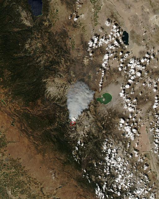
The Meadow Fire in Yosemite National Park is a remote, hold-over lightning caused fire which began on September 4 and is located five miles east of Yosemite Valley, CA. The fuel burning is timber and brush. There is active fire behavior w…
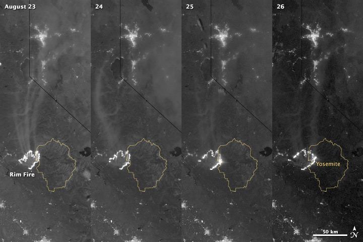
The winter of 2013 was among the driest on record for California, setting the stage for an active fire season. By August 26, the Rim Fire had made its way into the record books. At just 15 percent contained, the fire is now the 13th largest…
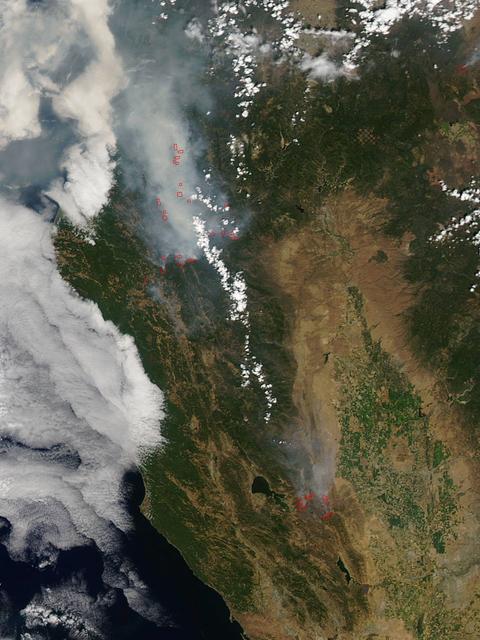
California has been hit hard the past few weeks with storms. Storms bring lightning and lightning strikes cause wildfires. Currently there are at least five fire complexes in the area including River, Fork, South, Route and Mad River. The…
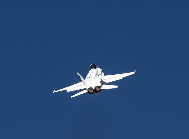
A NASA F/A‑18 aircraft flies over the Bakersfield Fire Department and surrounding community in California, on Friday, Sept. 11, 2026. The aircraft is based at NASA’s Armstrong Flight Research Center in Edwards, California. The flyover was p…

A Cal Fire S2-T airtanker is seen flying past the FreeFly Systems Alta X drone used during STEReO, the Scalable Traffic Management for Emergency Response Operations project, test activities, Wednesday, May 5, 2021 as Cal Fire conducts aeria…

A Cal Fire S2-T airtanker is seen as it drops water on a simulated wildfire, Tuesday, May 4, 2021 as Cal Fire conducts aerial fire fighting training exercises near Redding, California. STEReO, the Scalable Traffic Management for Emergency…

A Cal Fire S2-T airtanker is seen as it drops water on a simulated wildfire, Tuesday, May 4, 2021 as Cal Fire conducts aerial fire fighting training exercises near Redding, California. STEReO, the Scalable Traffic Management for Emergency…

A Cal Fire S2-T airtanker is seen above the STEReO, the Scalable Traffic Management for Emergency Response Operations project, ad-hoc network hub as it drops water on a simulated wildfire, Tuesday, May 4, 2021 as Cal Fire conducts aerial fi…

A Cal Fire S2-T airtanker drops water on a simulated wildfire, Tuesday, May 4, 2021, as Cal Fire conducts aerial fire fighting training exercises near Redding, California. STEReO, the Scalable Traffic Management for Emergency Response Oper…

With smoke from the Lake Arrowhead area fires streaming in the background, NASA's Ikhana unmanned aircraft heads out on a Southern California wildfires imaging mission.