STS058-92-064 (18 Oct-1 Nov 1993) --- This oblique view, looking northeast from central Egypt, shows great expanses of the sand covered and rocky Western Desert in the foreground (bottom).  The dark patches bottom right are the Dakhla Oases…
Earth observations during STS-58
The terrain for the scientific work conducted by ICESCAPE scientists on July 4, 2010, is Arctic sea ice and melt ponds in the Chukchi Sea. The five-week field mission is dedicated to sampling the physical, chemical and biological characteri…
ICESCAPE Mission
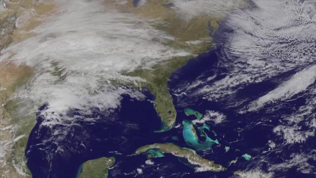
NOAA's GOES-East satellite captured an image of a powerful cold front that triggered flash flood watches and warnings along the U.S. East Coast on May 16. NOAA's National Weather Service noted flash flooding was possible from New England in…
Satellite Shows Powerful Cold Front Moving Off U.S. East Coast
Clark University's Luke Trusel works amid sea ice in the Chukchi Sea on July 9, 2010, and logs the depths at which measurements are collected below the ice. The research is part of NASA's ICESCAPE mission to sample the physical, chemical an…
ICESCAPE Mission
NOAA's GOES-15 satellite captured the southern California "June Gloom" on June 10, 2013. That's a weather pattern that creates cloudy, overcast skies and cool temperatures. The "June Gloom" of low lying stratus clouds fo…
Satellite Shows West Coast "June Gloom" and Actinoform clouds
S66-38290 (5 June 1966) --- The north coastal area of Peru looking southeast across the Andes Mountains as seen from the National Aeronautics and Space Administration's Gemini-9A spacecraft. The body of water is the Pacific Ocean. The image…
GEMINI-TITAN (GT)-9 - EARTH-SKY VIEW - PERU - OUTER SPACE
NASA Administrator Jared Isaacman, left, participates in a fireside chat with U.S. Rep. Mike Haridopolos of Florida’s 8th congressional district, right, Friday, Aug. 21, 2026, at the 8th Annual Space Coast Symposium & Expo in Cape Canaveral…
8th Annual Space Coast Symposium & Expo
NASA Administrator Jared Isaacman, left, participates in a fireside chat with U.S. Rep. Mike Haridopolos of Florida’s 8th congressional district, right, Friday, Aug. 21, 2026, at the 8th Annual Space Coast Symposium & Expo in Cape Canaveral…
8th Annual Space Coast Symposium & Expo
STS060-73-038 (3-11 Feb 1994) --- Pack ice is documented in this photograph along the coast of the Kamchatka Peninsula of Russia in Zaliv Ozernoj.  Newly formed ice continually breaks away from the land and takes the form imposed by coastal…
Pack ice along the Kamchatka Peninsula, Russia as seen from STS-60
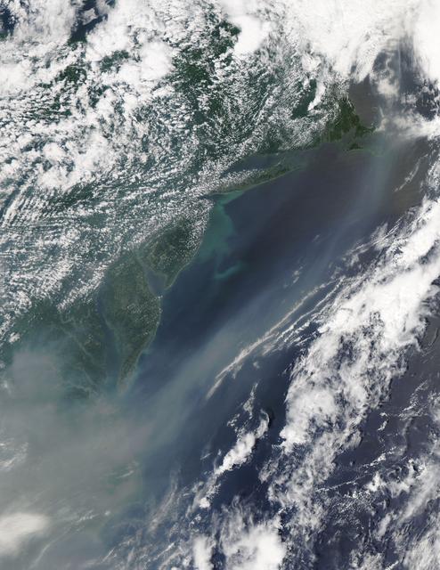
The smoke from the Canadian wildfires that was in the middle of the U.S. on June 30 has drifted its way to the East Coast obscuring parts of the coast from New Jersey to North Carolina.  Images taken on June 30 showed the smoke covering sta…
Canadian Smoke Now Over U.S. East Coast
STS060-84-021 (3-11 Feb 1994) --- The Kennedy Space Center (KSC) and its partially cloud-covered environs were captured on 70mm by one of the STS-60 crew members during the eight-day mission.  The Shuttle landing facility, on which Discover…
Kennedy Space Center, Florida as seen from STS-60
AST-16-1268 (20 July 1975) --- A near vertical view of a portion of the Mediterranean coast of Turkey and Syria, as photographed from the Apollo spacecraft in Earth orbit during the joint U.S-USSR Apollo-Soyuz Test Project mission. This vie…
View of portion of Mediterranean Coast of Turkey and Syria
STS058-100-073 (18 Oct-1 Nov 1993) --- An unusually clear, northwestward view of central North Carolina shows the farms and timber of the inner coastal plain.  The city of Fayetteville, and Fort Bragg to the west, is prominent at lower left…
North Carolina as seen from STS-58
SL4-138-3843 (1 Jan. 1974) --- A part of northern California centered near San Francisco Bay photographed at 3 p.m. Jan. 2, 1974, from the Skylab space station in Earth orbit. This near vertical view encompasses the coastline from Monterey…
Northern California near San Francisco
SL4-142-4548 (27 Jan. 1974) --- An oblique view of northwestern Mexico, as photographed from the Skylab space station in Earth orbit by one of the Skylab 4 crewmen. The camera used was a hand-held 70mm Hasselblad, with SO-368 medium-speed E…
Northwestern Mexico as photographed from Skylab
Scientists on the sea ice in the Chukchi Sea off the north coast of Alaska disperse equipment on July 4, 2010, as they prepare to collect data on and below the ice. The research is part of NASA's ICESCAPE mission onboard the U.S. Coast Guar…
ICESCAPE Mission
On April 5, 2015, the Moderate Resolution Imaging Spectroradiometer (MODIS) on NASA’s Terra satellite acquired this natural-color image of sea ice off the coast of East Antarctica’s Princess Astrid Coast.  White areas close to the continent…
Sea Ice off the Princess Astrid Coast
July 4 fireworks came early when a NASA Terrier-Improved Malemute sounding rocket was successfully launched at 4:25 a.m., Thursday, June 29, from the agency’s Wallops Flight Facility in Virginia.  During the 8-minute flight, 10 canisters ab…
NASA Wallops Rocket Launch Lights up the Mid-Atlantic Coast
Benny Hopson from the Barrow (Alaska) Arctic Science Consortium drills a core sample from sea ice in the Chukchi Sea on July 4, 2010. The core is sliced up into puck-sized sections and stored onboard the U.S. Coast Guard Healy for analysis…
ICESCAPE Mission
Dartmouth College's Chris Polashenski cuts a block of ice from below a melt pond on sea ice in the Chukchi Sea on July 9, 2010, for analysis upon return from the mission. The research is part of NASA's ICESCAPE mission onboard the U.S. Coas…
ICESCAPE Mission
NASA Administrator Jared Isaacman, left, participates in a fireside chat with U.S. Rep. Mike Haridopolos of Florida’s 8th congressional district, right, Friday, Aug. 21, 2026, at the 8th Annual Space Coast Symposium & Expo in Cape Canaveral…
8th Annual Space Coast Symposium & Expo
NASA Administrator Jared Isaacman, left, participates in a fireside chat with U.S. Rep. Mike Haridopolos of Florida’s 8th congressional district, center, Friday, Aug. 21, 2026, at the 8th Annual Space Coast Symposium & Expo in Cape Canavera…
8th Annual Space Coast Symposium & Expo
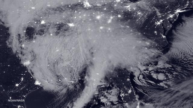
NASA and NOAA satellites are tracking the large winter storm that is expected to bring heavy snowfall to the U.S. mid-Atlantic region on Jan. 22 and 23. NASA-NOAA's Suomi NPP satellite snapped this image of the approaching blizzard around 2…
Blizzard Bears Down on U.S. East Coast
Scientists on board the U.S. Coast Guard Cutter Healy in the Beaufort Sea, northeast of Barrow, Alaska, finished collecting the mission¹s sea ice data and cruised south on July 20, 2011, through thin ice and ultimately into the open ocean.…
U.S. Coast Guard Cutter Healy in the Beaufort Sea
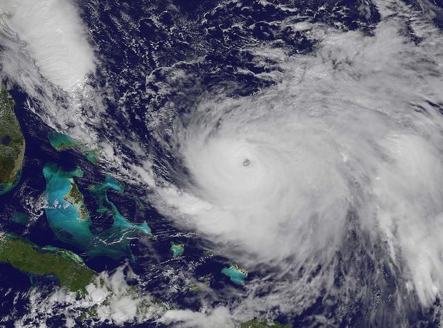
NOAA's GOES-East satellite captured this visible image of Hurricane Joaquin east of the Bahamas on Oct. 3 at 1615 UTC (12:15 p.m. EDT).  The national weather forecast for October 3, 2015: Joaquin is no threat for now, but the nor'easter on…
Joaquin moves away from East Coast
Phytoplankton bloom in the Great Australian Bight captured by the MODIS instrument on the Aqua satellite on December 30, 2013 at 6:05 UTC.  The Great Australian Bight is a large bight, or open bay, off the central and western portions of th…
Phytoplankton Bloom off Coast of Australia
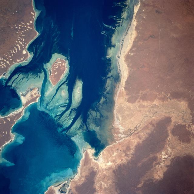
A nearly vertical view of Disappointment Reach and surroundings. Ripple-like patterns extending at right angles to the tidal flow can be discerned on shoals. Relict sand dune patterns, crests unvegetated, are evident on the western side of…
Disappointment Reach, Australia as seen from STS-67 Endeavour
The MODIS instrument on NASA's Aqua satellite captured this visible image of Tropical Storm Isaac on Aug. 27 at 3:00 p.m. EDT is it was moving northwest through the Gulf of Mexico. Issac's large reach is seen by its eastern cloud cover over…
NASA Watching Issac's Approach to U.S. Gulf Coast
Clark University's Karen Frey and Luke Trusel work amid sea ice in the Chukchi Sea on July 4, 2010, setting up an instrument that measures the optical properties of melt ponds. The research is part of NASA's ICESCAPE mission to sample the p…
ICESCAPE Mission
S66-54563 (14 Sept. 1966) --- View of the Gulf Coast area from Atchafalaya Bay to Apalachicola, including the mouth of the Mississippi River, Mobile Bay, New Orleans, Louisiana, and Pensacola, Florida, as seen from the Gemini-11 spacecraft…
Gulf Coast from from Atchafalaya Bay to Apalachicola seen from Gemini 11
NOAA's GOES-East satellite captured this visible image of Hurricane Joaquin east of the Bahamas on Oct. 3 at 1615 UTC (12:15 p.m. EDT).  The national weather forecast for October 3, 2015: Joaquin is no threat for now, but the nor'easter on…
Joaquin moves away from East Coast
NASA Orion Egress Test
Orion crew egress testing
NASA Orion Egress Test
Orion crew egress testing
NASA Administrator Jared Isaacman speaks during a fireside chat, Friday, Aug. 21, 2026, at the 8th Annual Space Coast Symposium & Expo in Cape Canaveral, Fla. Photo Credit: (NASA/John Kraus)
8th Annual Space Coast Symposium & Expo
Scientists and Coast Guard swimmers test the integrity a melt pond on sea ice in the Chukchi Sea on July 9, 2010, before drilling holes through which instruments can be deployed to collect data. The research is part of NASA's ICESCAPE missi…
ICESCAPE Mission
July 4 fireworks came early when a NASA Terrier-Improved Malemute sounding rocket was successfully launched at 4:25 a.m., Thursday, June 29, from the agency’s Wallops Flight Facility in Virginia.  During the 8-minute flight, 10 canisters ab…
NASA Wallops Rocket Launch Lights up the Mid-Atlantic Coast
Teams of scientists set up equipment on sea ice not far from the U.S. Coast Guard icebreaker Healy in the Chukchi Sea on July 4, 2010, where they spent the day collecting data. The research is part of NASA's ICESCAPE oceanographic mission t…
ICESCAPE Mission
S65-63766 (12 Dec. 1965) --- Ras Azir on the coast of the Republic of Somali, looking east, as seen from the National Aeronautics and Space Administration's Gemini-7 spacecraft during its 117th revolution of Earth. Taken with a modified 70m…
Earth Sky- GT-7
NASA and NOAA satellites are providing various views of the major winter storm marching toward the U.S. East coast on March 13. The storm is forecast to merge with another system and is expected to bring large snowfall totals from the Mid-A…
Satellites see major winter storm marching toward the U.S. East Coast
NASA Administrator Jared Isaacman, left, participates in a fireside chat with U.S. Rep. Mike Haridopolos of Florida’s 8th congressional district, right, Friday, Aug. 21, 2026, at the 8th Annual Space Coast Symposium & Expo in Cape Canaveral…
8th Annual Space Coast Symposium & Expo
NASA Administrator Jared Isaacman, center, participates in a fireside chat with U.S. Rep. Mike Haridopolos of Florida’s 8th congressional district, right, Friday, Aug. 21, 2026, at the 8th Annual Space Coast Symposium & Expo in Cape Canaver…
8th Annual Space Coast Symposium & Expo
STS060-88-070 (3-11 Feb 1994) --- This view shows sunglint in the Strait of Gibralter.  In this photograph a high pressure atmospheric system over the Iberian Peninsula has set the conditions for seeing a plankton bloom along the Moroccan c…
Strait of Gibraltar as seen from STS-60
STS058-107-046 (18 Oct-1 Nov 1993) --- Clouds streak across central Florida in this striking photograph which includes the Florida Peninsula, Andros Island of the northern Bahamas and Cuba (lower left).  The light blue, shallow bank of the…
Florida and the Bahamas as seen from STS-58
STS060-84-063 (3-11 Feb 1994) --- This is an excellent photograph of the coastal city of Santo Domingo on the Caribbean Sea.  The airports including De las Americas International Airport are clearly seen.  This photo illustrates the resolvi…
Santo Domingo, Dominican Republic as seen from STS-60
This image was taken by GOES East at 1445Z on October 23, 2015.    Credit: NASA/NOAA via <b><a href="www.nnvl.noaa.gov/" rel="nofollow"> NOAA Environmental Visualization Laboratory</a></b>  <b><a href="http://www.nasa.gov/audience/formedia/…
Historic Hurricane Patricia Bears Down on Mexico's Pacific Coast
AS09-22-3436 (March 1969) --- Los Angeles-Long Beach area of southern California, as photographed from the Apollo 9 spacecraft during its 92nd revolution of Earth. Santa Catalina Island is located off the coast. The California coastline is…
Los Angeles-Long Beach area of Southern California as seen from Apollo 9
STS058-73-024 (18 Oct-1 Nov 1993) --- The ancient eruption of Vesuvius (the volcano near the center of the frame) destroyed the town of Pompeii located on its southeast flank.  But the larger town of Naples, between Vesuvius (to the south)…
Mt. Vesuvius and Naples, Italy as seen from STS-58
S66-54559 (14 Sept. 1966) --- Gulf Coast from Corpus Christi, Texas, to mouth of Mississippi River, as seen from the Gemini-11 spacecraft during its 29th revolution of Earth. This photo was taken near sunrise. Photo credit: NASA
Gulf Coast from Corpus Christi to mouth of Mississippi river from Gemini 11