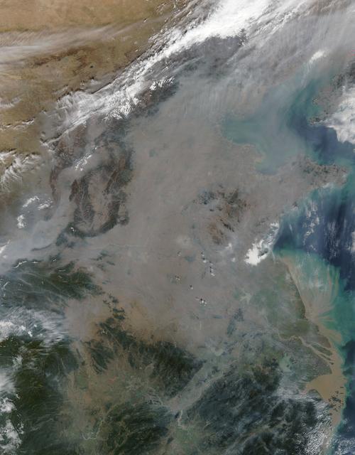
On October 17, 2015, the Moderate Resolution Imaging Spectroradiometer (MODIS) aboard NASA’s Terra satellite captured this true-color image of a thick haze hanging over eastern China. In the north, the large city of Beijing is completely ob…
Haze over eastern China
The Moderate Resolution Imaging Spectroradiometer or MODIS instrument that flies aboard NASA's Terra satellite captured this image of Typhoon Usagi on Sept. 22 at 02:45 UTC/Sept. 21 at 10:45 p.m. EDT on its approach to a landfall in China.…
Typhoon Usagi approaching China
NASA image acquired May 17, 2011  Located in China’s resource-rich but moisture-poor Xinjiang autonomous region, Lop Nur is an uninviting location for any kind of agriculture. It sits at the eastern end of the Taklimakan Desert, where march…
Lop Nur, Xinjiang, China
Low clouds over the Yellow Sea and the East China Sea was captured by the MODIS instrument on the Aqua satellite on April 1, 2016 at 4:55 UTC.  Credit: NASA/Goddard/Jeff Schmaltz/MODIS Land Rapid Response Team  <b><a href="http://www.nasa.g…
Low clouds over the Yellow Sea and the East China Sea
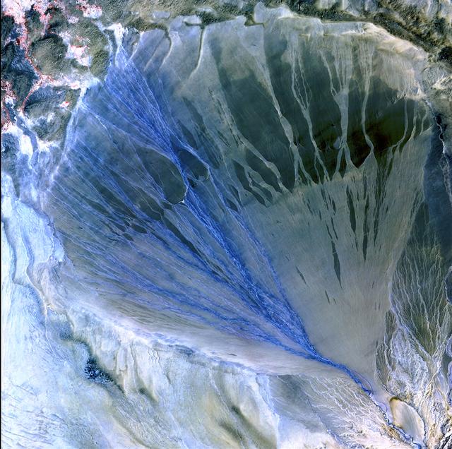
Image taken 5/2/2002 by ASTER: A vast alluvial fan blossoms across the desolate landscape between the Kunlun and Altun mountain ranges that form the southern border of the Taklimakan Desert in China's XinJiang Province.     This image can b…
Alluvial Fan, China
STS066-208-025 (3-14 Nov. 1994) --- Mount Everest, the highest mountain in the world at 8,848 meters, was photographed by the crew members aboard the Space Shuttle Atlantis from 165 nautical miles above Earth.  Also seen are Cho Oyu (8,153…
Mt. Everest as seen from STS-66 shuttle Atlantis
On August 9 at 03:00 UTC (Aug. 8 at 11 p.m. EDT) the MODIS instrument aboard NASA's Terra satellite passed over the remnant clouds of Typhoon Soudelor when it was over eastern China.    By 22:35 UTC (6:35 p.m. EDT) on August 8, 2015, Typhoo…
NASA Sees Typhoon Soudelor's Remnants Over Eastern China
STS007-05-245 (18-24 June 1983) --- A rare view of internal waves in the South China Sea.  Several different series of internal waves are represented in the 70mm frame,  exposed with a handheld camera by members of the STS-7 astronaut crew…
Internal Waves, South China Sea
STS058-101-014 (18 Oct-1 Nov 1993) --- The best, most-nearly cloud-free, shuttle view yet of Mount Everest, the highest mountain in the world at 29,028 feet. The peak, on the border between Nepal and China, is almost exactly in the center o…
Mount Everest as seen from STS-58
S66-54839 (14 Sept. 1966) --- China, India, and Nepal, looking east, as seen from the Gemini-11 spacecraft during its 37th revolution of Earth. The Great Himalaya Mountain Range is clearly visible. Photo credit: NASA
China, India, and Nepal as seen from Gemini 11
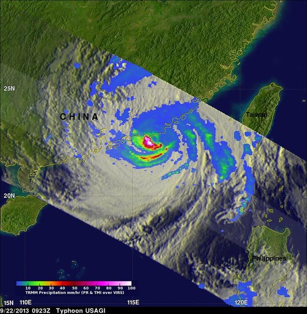
On Saturday, Sept. 21, TRMM captured rainfall data on Typhoon Usagi as it passed between the northern Philippines and southern Taiwan. TRMM found rain falling at a rate of over 134 mm/hr (~5.2 inches) in USAGI's eye wall.   Credit: SSAI/NAS…
Typhoon Usagi approaching China
Chinese authorities shut down much of Harbin – a city of more than 10 million people – as unusually high levels of pollution shrouded the city and the surrounding region in mid-October, 2013. Measurements taken on October 20, 2013 scored th…
Haze in northeastern China
The skies over northern China were shrouded with a thick haze in late December, 2013. The Moderate Resolution Imaging Spectroradiometer (MODIS) aboard the Terra satellite captured this true-color image on December 23.  The dense, gray haze…
Haze over eastern China
iss071e439833 (Aug. 8, 2024) --- Xiang River runs through the city of Changsha (center) in China's province of Hunan. At far left, the city of Yueyang lies on the bank of Dongdongting Lake in Hunan's humid, subtropical region. The Internati…
Xiang River runs through the Chinese city of Changsha
The northwest-southeast trending, snow-covered, linear mountain range is the King Ata Tag Mountain, located in extreme western most China. Highest peaks are just over 20,100 feet above sea level. The town or village of Muji is located in th…
King Ata Tag Mountain Range, western China as seen by STS-66 Atlantis
iss071e439834 (Aug. 8, 2024) --- The Yangtze River beams in the Sun's glint as wildfires burn in the surrounding forestland near the city of Wuhan in China's province of Hubei. The International Space Station was orbiting 262 miles above th…
The Yangtze River beams in the Sun's glint and surrounded by wildfires
On Sept. 21, Typhoon Usagi was moving between the northern Philippines and Taiwan when NASA's Aqua satellite passed overhead. NASA's AIRS instrument that flies aboard the Aqua satellite captured this near-infrared image on Sept. 21 at 505 U…
Near-Infrared Image of Typhoon Usagi Between Taiwan and the Philippines
STS-56 Earth observation shows of some of the highest mountain peaks in the world taken from Discovery, Orbiter Vehicle (OV) 103, as it passed over India and China. The top of the view shows one of the snow and ice-covered massifs in the gr…
STS-56 Earth observation of Karakorum Range of north India
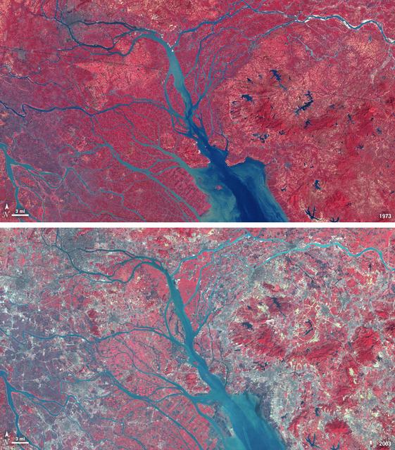
In 1979, China established two special economic zones around the Pearl River Delta, north of Hong Kong. This image, taken by Landsat 3 on October 19, 1973, shows that the region was rural when the zone was established. Plant-covered land, w…
Landsat View: Pearl River Delta, China
STS059-220-041 (9-20 April 1994) --- View to the south by southwest across the southern Gobi Desert (China) across the Chi-Lien-Shan or Quilienshan or Nanshan (Mountains) in Gansu Province to Lake Quinghai or Ch'ing-Hai (orthography varies…
Gobi Desert, China as seen from STS-59
Surplus Navy Phoenix missiles like this one mounted on the centerline pylon of NASA's F-15B research aircraft may be used to acquire hypersonic flight test data.
Surplus Phoenix missiles like this one mounted on the centerline pylon of NASA's F-15B research aircraft may be used to acquire hypersonic flight test data.
On Sept. 22 at 0923 UTC/5:23 a.m. EDT,  just south of Usagi's eye where rain was falling at a rate of over 169mm/~6.7 inches per hour along China's coast.  TRMM radar sliced through Usagi and found that heights of some thunderstorms were re…
Typhoon Usagi approaching China
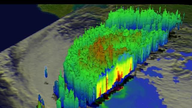
This simulated 3-D flyby animation over Typhoon Usagi on Sept. 22 at 0923 UT showed heavy rain south of the center a rate of over 169mm/~6.7 inches per hour along China's coast. Cloud heights of some thunderstorms were reaching only about 1…
Typhoon Usagi approaching China
A thick layer of haze blanketed the North China Plain on October 9, 2014, when the Moderate Resolution Imaging Spectroradiometer (MODIS) on NASA’s Terra satellite acquired this natural-color image at 2:50 Coordinated Universal Time (10:50 a…
Haze over Eastern China
The Moderate Resolution Imaging Spectroradiometer (MODIS) on NASA’s Terra satellite acquired this natural-color image of central China on January 23, 2013 at 04:05 UTC. The image shows extensive haze over the region.  In areas where the gro…
Haze in central China
On Nov. 10 at 03:30 UTC/Nov. 9 at 10:30 p.m. EDT, the MODIS instrument aboard NASA's Terra satellite showed the center of Typhoon Haiyan just south of Hainan Island, China in the South China Sea.   Credit: NASA Goddard MODIS Rapid Response…
Typhoon Haiyan Near Hainan Island, China
The MODIS instrument on NASA's Aqua satellite captured Typhoon Neoguri in the East China Sea at 05:00 UTC (1:00 AM EDT) on July 8, 2014.  Typhoon Neoguri hit Japan’s Okinawa islands on Tuesday local time (July 8, 2014), bringing high winds,…
Typhoon Neoguri in the East China Sea
NASA satellite imagery from July 10 revealed a very clear and cloudless eye in the Northwestern Pacific’s Typhoon Soulik as it moves toward a landfall in China by the end of the week.  The Moderate Resolution Imaging Spectroradiometer (MODI…
NASA Gets an Eye-Opening Look at Typhoon Soulik
View is southeastward across China (Tibet), half of Nepal and India. The partly frozen lake near the center of the frame is Pei-Ku T'so ("Bos-tie Lake"). The central Himalaya stretches from Mount Everest on the left past Annapurna on the ri…
Himalayas as seen from STS-66 shuttle Atlantis
STS066-124-059 (3-14 Nov. 1994) --- Mount Everest region, Nepal and China. Low morning Sun highlights Mount Everest (the highest mountain in the world at 8,848 meters), Cho Oyu (8,153 meters) to the northwest, and other peaks of "The Roof o…
Mount Everest region as seen from the STS-66 orbiter Atlantis
STS001-12-350 (12-14 April 1981) --- India and China, the Ladokh and Zaskar Ranges of the Great Himalaya are clearly etched by snow and shadow. A detailed view shows the glaciation process over a wide area. Photo credit: NASA
Himalayan Mountain Range
An inert AIM-54 Phoenix missile nestled under the fuselage of NASA Dryden's F-15B aircraft is being studied as a possible test vehicle to obtain hypersonic data.
An inert Phoenix missile nestled under the fuselage of NASA Dryden's F-15B aircraft is being studied as a possible test vehicle to obtain hypersonic data.
NASA Dryden aircraft and avionics technicians (from left) Bryan Hookland, Art Cope, Herman Rijfkogel and Jonathan Richards install the nose cone on a Phoenix missile prior to a fit check on the center's F-15B research aircraft.
NASA Dryden aircraft and avionics technicians install the nose cone on an inert Phoenix missile prior to a fit check on the center's F-15B research aircraft.
No more images