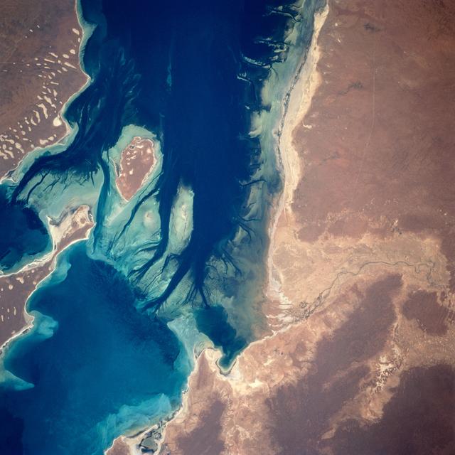
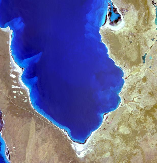
Hamelin Pool Marine Nature Reserve is located in the Shark Bay World Heritage Site in Western Australia. It is one of the very few places in the world where living stromatolites can be found. These are the first living examples of structure…
Shark Bay, Australia
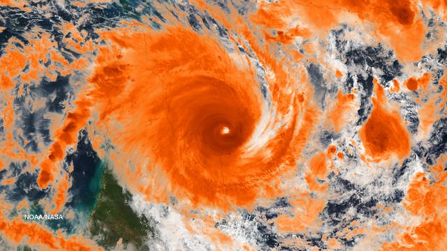
NASA image acquired January 30, 2011 at 23:20 UTC.  Satellite: Terra  <b> Click here to see the most recent image captured Feb. 1: <a href="http://www.flickr.com/photos/gsfc/5407540724/">www.flickr.com/photos/gsfc/5407540724/</a></b>  Tropi…
NASA Sees Large Tropical Cyclone Yasi Headed Toward Queensland, Australia
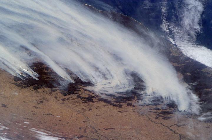
NASA image acquired January 28, 2011  Tropical Cyclone Bianca continued moving southward along the coast of Western Australia on January 28, 2011. At 5:00 a.m. on January 28 local time (21:00 UTC on January 27), the U.S. Navy’s Joint Typhoo…
Tropical Cyclone Bianca
Phytoplankton bloom in the Great Australian Bight captured by the MODIS instrument on the Aqua satellite on December 30, 2013 at 6:05 UTC.  The Great Australian Bight is a large bight, or open bay, off the central and western portions of th…
Phytoplankton Bloom off Coast of Australia
AS12-50-7362 (14 Nov. 1969) --- A view of one-third of Earth, with Australia on the horizon, as photographed by the three-man crew of Apollo 12. The Command and Service Modules, mated to the Lunar Module (yet to be removed and transposition…
View of the Earth seen from the Apollo 12 spacecraft
STS061-65-015 (9 Dec 1993) --- A fish-eye lens was used to capture the Hubble Space Telescope (HST), a spherical Earth and Australian landmass with a bit of distortion during the final extravehicular activity (EVA) on the STS-61 HST-servici…
Fisheye view of HST, spherical Earth and Australian landmass
AST-16-1132 (20 July 1975) --- A vertical view of the eastern portion of the state of South Australia in Australia, as photographed from the Apollo spacecraft in Earth orbit during the joint U.S.-USSR Apollo-Soyuz Test Project mission. The…
Eastern portion of State of South Australia in Australia
STS035-81-040 (2-10 Dec 1990) --- Numerous algae reefs are seen in Shark Bay, Western Australia, Australia (26.0S, 113.5E) especially in the southern portions of the bay. The south end is more saline because tidal flow in and out of the bay…
Algae Reefs in Shark Bay, Western Australia, Australia
AS07-04-1609 (21 Oct. 1968) --- Woodlark Island in the Solomon Sea, east of New Guinea and northeast of Australia, as seen from the Apollo 7 spacecraft during its 158th revolution of Earth. Photographed from an altitude of 140 nautical mile…
Woodlark Island in Solomon Sea as seen from the Apollo 7 spacecraft
NASA image acquired April 18 - October 23, 2012  This image of Asia and Australia at night is a composite assembled from data acquired by the Suomi NPP satellite in April and October 2012. The new data was mapped over existing Blue Marble i…
Black Marble - Asia and Australia
SL3-27-180 (July-September 1973) --- A vertical view of the Snowy Mountains area of Australian Alps in the States of Victoria and New South Wales, Australia, as photographed from Earth orbit by one of the six lenses of the Itek-furnished S1…
View of Snowy Mountains area of Australian Alps as photographed from Skylab
STS061-95-075 (6 Dec 1993) --- Astronauts Kathryn C. Thornton and Thomas D. Akers work to remove one of the solar arrays on the Hubble Space Telescope (HST) on the second of five extravehicular activity?s (EVA).  The two space walkers later…
Astronauts Akers and Thornton remove one of HST solar arrays during EVA
Lake Mackay is the largest of hundreds of ephemeral lakes scattered throughout Western Australia and the Northern Territory, and is the second largest lake in Australia. The darker areas indicate some form of desert vegetation or algae, moi…
Lake Mackay, Australia
In late July 2013, a low pressure system off Australia’s southeast coast and moist onshore winds combined to create unsettled weather across central Australia – and a striking image of a broad cloud band across the stark winter landscape.…
Unsettled weather across central Australia
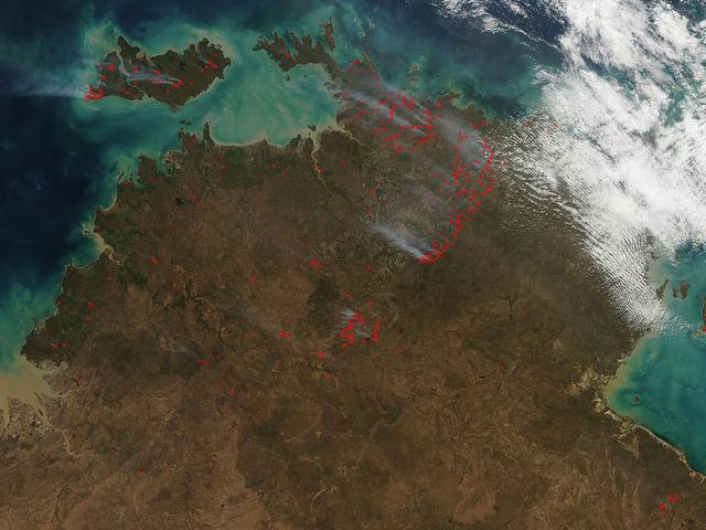
The Aqua satellite collected this natural-color image of fires in Australia with the Moderate Resolution Imaging Spectroradiometer (MODIS) instrument on June 30, 2017.  The image looks at multiple fires and smoke from those fires burning in…
Fires in Australia's Northern Territory and Bathurst Island
NASA image acquired January 28, 2011  High res file here: <a href="http://www.flickr.com/photos/gsfc/5400445475">www.flickr.com/photos/gsfc/5400445475</a>  Tropical Cyclone Bianca continued moving southward along the coast of Western Austra…
Tropical Cyclone Bianca [detail]
STS035-501-007 (2-10 Dec. 1990) --- The STS-35 crewmembers aboard the Earth-orbiting Space Shuttle Columbia photographed this view of the Arid Simpson Desert of Australia with a handheld Rolleiflex camera. Lake Eyre is normally dry; however…
Lake Eyre, Simpson Desert, South Australia, Australia
A nearly vertical view of Disappointment Reach and surroundings. Ripple-like patterns extending at right angles to the tidal flow can be discerned on shoals. Relict sand dune patterns, crests unvegetated, are evident on the western side of…
Disappointment Reach, Australia as seen from STS-67 Endeavour
51I-32-023 (27 Aug. 1985) --- Australia's AUSSAT communications satellite is deployed from the payload bay of the space shuttle Discovery on flight day one. A portion of the cloudy surface of Earth can be seen to the left of the frame. Phot…
Australia's AUSSAT satellite deployed from payload bay
This image is a color composite of the supernova remnant E0102-72: x-ray (blue), optical (green), and radio (red). E0102-72 is the remnant of a star that exploded in a nearby galaxy known as the Small Magellanic Cloud. The star exploded out…
History of Chandra X-Ray Observatory
This image of abstract shapes is comprised numerous subparallel, very long, orange colored linear dunes and patchy grey dry lakes (playas). The dunes are aligned north to south in the great central basin of Astralia (27.0S, 138.0E). The reg…
Linear Dunes and Playas, Simson Desert, South Australia, Australia
NASA image March 29, 2010  Tropical Cyclone Paul spanned the ocean waters between Australia and New Guinea on March 29, 2010. The MODIS on NASA’s Terra satellite captured this natural-color image the same day. The center of the cyclone is a…
Tropical Cyclone Paul
NASA image acquired March 18, 2010.  Tropical Cyclone Ului persisted south of the Solomon Islands on March 18, 2010. A bulletin from the U.S. Navy’s Joint Typhoon Warning Center (JTWC) issued the same day reported that the cyclone had maxim…
NASA Satellite Image of Tropical Cyclone Ului
STS048-151-250 (12-18 Sept. 1991) --- The Great Barrier Reef extends for roughly 2,000 kilometers along the northeast coast of Australia.  The great Barrier Reef is made up of thousands of individual reefs which define the edge of the conti…
Great Barrier Reef, Queensland, Australia
This dramatic image of the Australian brushers was taken from orbit by one of the crew members aboard the International Space Station (ISS). Following the worst regional drought in 50 years, this summer's fire season has resulted in numerou…
Earth Science
NASA's Aqua satellite passed over Tropical Cyclone Ita as it began making landfall on the Eastern Cape York Peninsula of Queensland, Australia, today, April 11, 2014. Ita officially made landfall at Cape Flattery about 9:00 p.m. local AEST…
Powerful Tropical Cyclone Ita Making Landfall in Queensland, Australia
Residents of the northeast coast of Queensland, Australia are facing high winds, dangerous tides and very heavy rain between Cape Melville and Cooktown. These hazards will migrate southward for the next few days as the center of the storm r…
Tropical Cyclone Ita Off-Shore Queensland, Australia
The Exmouth Gulf, western Australia, is bounded on the west by the Cape Ranges; near the base of the peninsula the Learmonth Airfield, site of a solar observatory, can be seen. Spit-accretion ridges formed on ancient beaches extend along th…
Exmouth Gulf, Australia as seen from STS-67 Endeavour
STS062-106-042 (4-18 March 1994) --- This view of southern Australia about 100 miles northwest of Melbourne shows areas of protected reserves of natural forests in the midst of agricultural crop lands.  The green patch seen here has been re…
Australia fires and burn scars as seen from STS-62
STS062-58-025 (4-18 March) --- This photo shows the aurora australis or souther lights. The multi-hued shafts of light, extending upward to 200 miles above the earth's surface, are caused by beams of energetic electrons colliding with the o…
Aurora Australis as seen from STS-62
AST-19-1550 (24 July 1975) --- A vertical view of the Lake Eyre Basin area in the state of South Australia in Australia, as photographed from the Apollo spacecraft in Earth orbit during the joint U.S.-USSR Apollo-Soyuz Test Project mission.…
View of the Lake Eyre Basin area in State of South Australia in Australia
STS032-520-014 (9-20 Jan. 1990) --- STS-32 astronauts took this 70mm scene showing phytoplankton oralgal bloom in the northwest Coral Sea.  The Western Coral Sea and the Great Barrier Reef waters offshore Queensland, Australia are the sites…
STS-32 Earth observation of the western Coral Sea and the Great Barrier Reef
Cairns and Townsville area, on the northeast coast of Queensland, Australia (17.0S, 146.0E) is one of the best sport diving localities in the world where divers can explore the rich and varied flora and fauna of the nearby Great Barrier Ree…
Cairns and Townsville area, Queensland, Australia
STS-56 Earth observation taken aboard Discovery, Orbiter Vehicle (OV) 103, is probably the best view of Perth in Western Australia. (For orientation purposes, note that the coastline runs north and south). The major feature on the coast is…
STS-56 Earth observation of Perth in Western Australia
STS061-53-026 (4 Dec 1993) --- One of the Space Shuttle Endeavour's aft flight deck windows frames this view of the Hubble Space Telescope (HST) as it approaches the Endeavour.  Backdropped against western Australia, the Remote Manipulator…
View of HST as it approaches Endeavour, taken from aft flight deck window
No more images